January 16 , 2020 .
Philippines , Taal :
The thunderous awakening of the Taal volcano.
After 42 years of calm, the Taal volcano, the volcano formed in the lake of the island of Luzon, in the Philippines has erupted.
At 1:00 p.m. (local time, Italian time +7) on January 12, 2020, a phreatic eruption occurred with the emission of a vapor column up to 100 m high, which came from the main lake of the crater, ( 1.4 x 1.2 km in size) of the Taal volcano on the island of Luzon, in the Philippine archipelago (Figure 1). The Taal volcano is a 8.2 km wide, 7 km long and 311 m high stratovolcano, which forms an island located almost in the center of Lake Taal. The lake in turn formed in a large volcanic caldera (24 x 14.5 km) and is located 50 km south of the metropolitan area of Manila and 16 km northeast of the coast of the bay of Balayan.
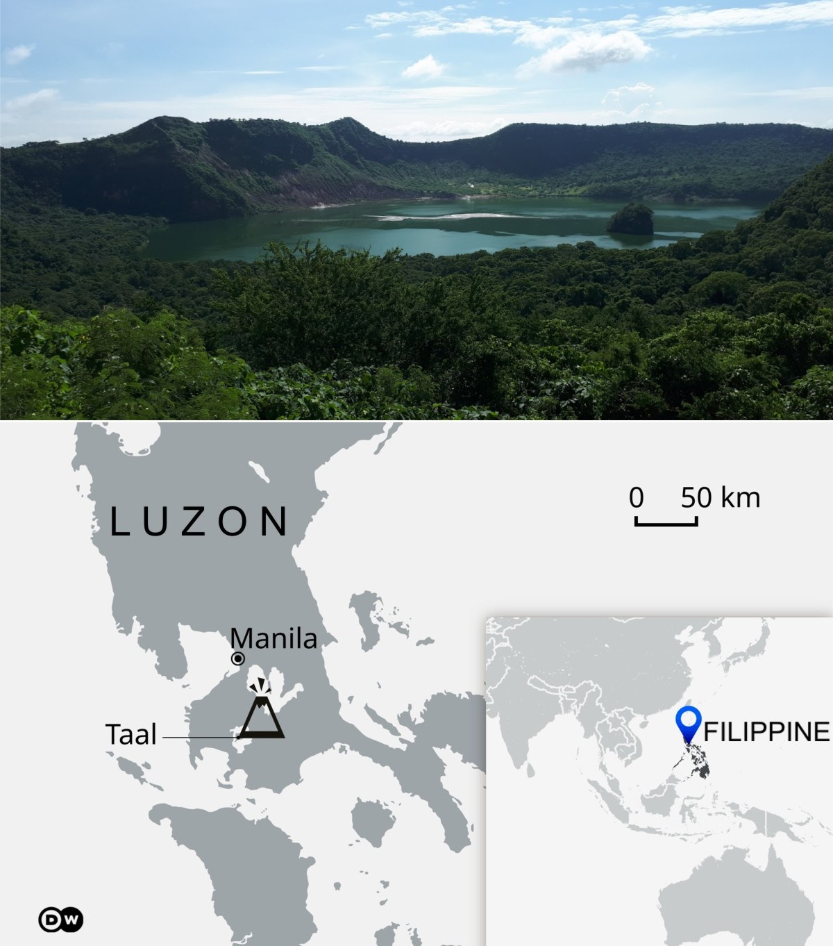
Figure 1. Above: the main crater lake of the Taal volcano before the eruption of January 12, 2020. Hydrothermal activity (fumaroles) near the shore and convection in the center of the lake are appreciated (photo by Corentin Caudron). Below: map of the island of Luzon with the location of the Taal (modified from the Deutsche Welle website).
During the following hours (between 1 p.m. and 4 p.m.), the activity of groundwater intensified with the emission of steam columns up to a kilometer high, accompanied by a fall of ash (Figure 2). The alert level was therefore raised by the Philippine Volcanological Observatory PHIVOLCS (Philippine Institute of Volcanology and Seismology), going from 1 to 3, indicating the possibility of a magmatic eruption in the hours or days following. In the case of Taal, however, level 1 indicates that the island of the Taal volcano is an area of permanent danger. Level 2 indicates the occurrence of signs of awakening of the volcano (in English unrest). Level 3, on the other hand, indicates the presence of explosive activity and the possibility of dangerous pyroclastic flows forming in the event of a collapse of the eruptive column which, in turn, when entering the water, can cause tsunami waves in Taal Lake.
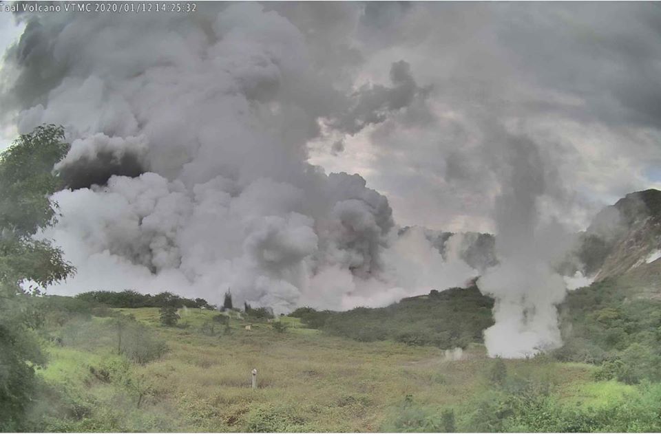
Figure 2. Beginning of phreatic activity in the main crater of Taal and recorded by a webcam of the Volcanological Observatory of the Philippines (PHIVOLCS), at 2:25 p.m. (local time) on January 12, 2020.
The particular geographical context of Taal has implications for eruptive dynamics and could favor a possible sudden escalation of eruptive phenomena. Indeed, the presence of water, both in the immediate vicinity of the volcano and inside it when it forms groundwater, can generate an explosive activity linked to the hydrothermal system whatever the direct interaction between the water and magma.
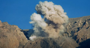
The direct involvement of magma in the subsequent phreato-magmatic phase of the January 12 eruption, generated an eruptive column which reached a height of between 10 and 15 km, with a dispersion of the ashes in a north direction, towards Manila (from 5.30 p.m. local time). The alert level was therefore raised to 4, indicating an impending dangerous eruption (level 5, the highest in the Philippines, declares « a dangerous eruption in progress »). In the evening, an intense lightning storm hits the eruptive column, generated by the friction between the ash particles and the presence of water vapor (Figure 3).
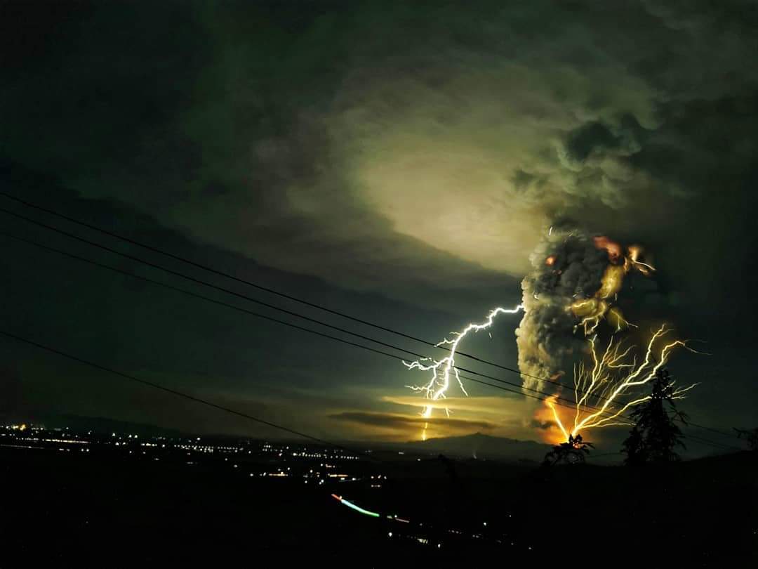
Figure 3. Eruptive column and lightning strikes during the main explosive phase, on the evening of January 12, 2020. Photo published by ABS-CBN News, Philippines.
The very intense groundwater activity on January 12 caused a depressurization of the magmatic system and an increase in magma in the volcano’s conduits, with the consequence of true hydromagmatic and magmatic activity at night (from 2:49 local time on January 13). It is in this interval that the eruptive column has reached its maximum height of at least 15 km. Subsequently, the activity was characterized by lava fountains up to 500 m high (Figure 4), accompanied by lightning and thunder from various eruptive vents inside the crater, until the morning of 12 January which filled the lake of the main crater of Taal. A drone inspection on the morning of January 15 revealed that the lake had, at least temporarily, disappeared.
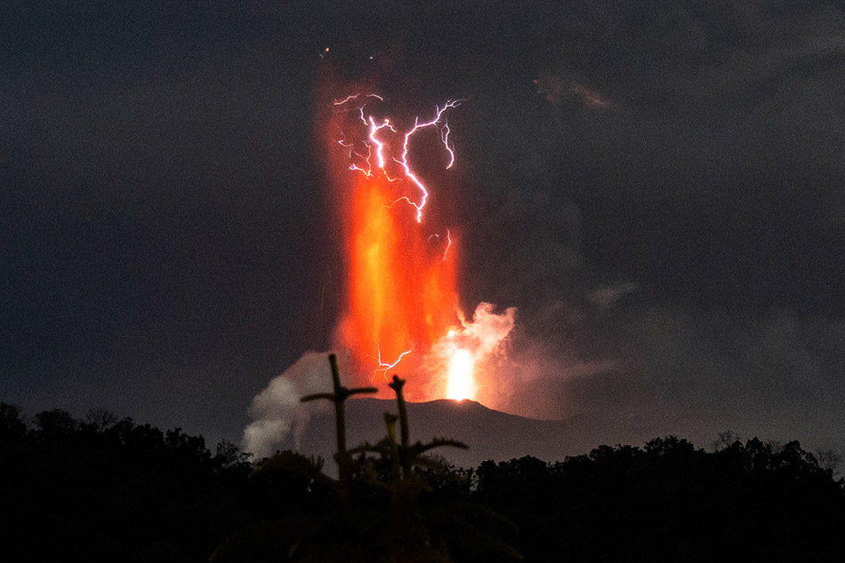
Figure 4. Lava fountain accompanied by lightning in the eruptive cloud (early January 13). Photo by Paul Quiambao, ABS-CBN News, Philippines.
The opening of new eruptive vents in the northern sector of the island was also observed on the morning of January 13. At the same time, seismic activity has increased, both in number of events (466 earthquakes from 12 to 15 January) as in amplitude (up to M4) and in intensity (up to 5 on the Mercalli scale ). In addition, the formation of soil fractures is observed in the areas southwest and north of Lake Taal (Figure 5), a clear indicator that the migration of magma to the surface is not yet complete.
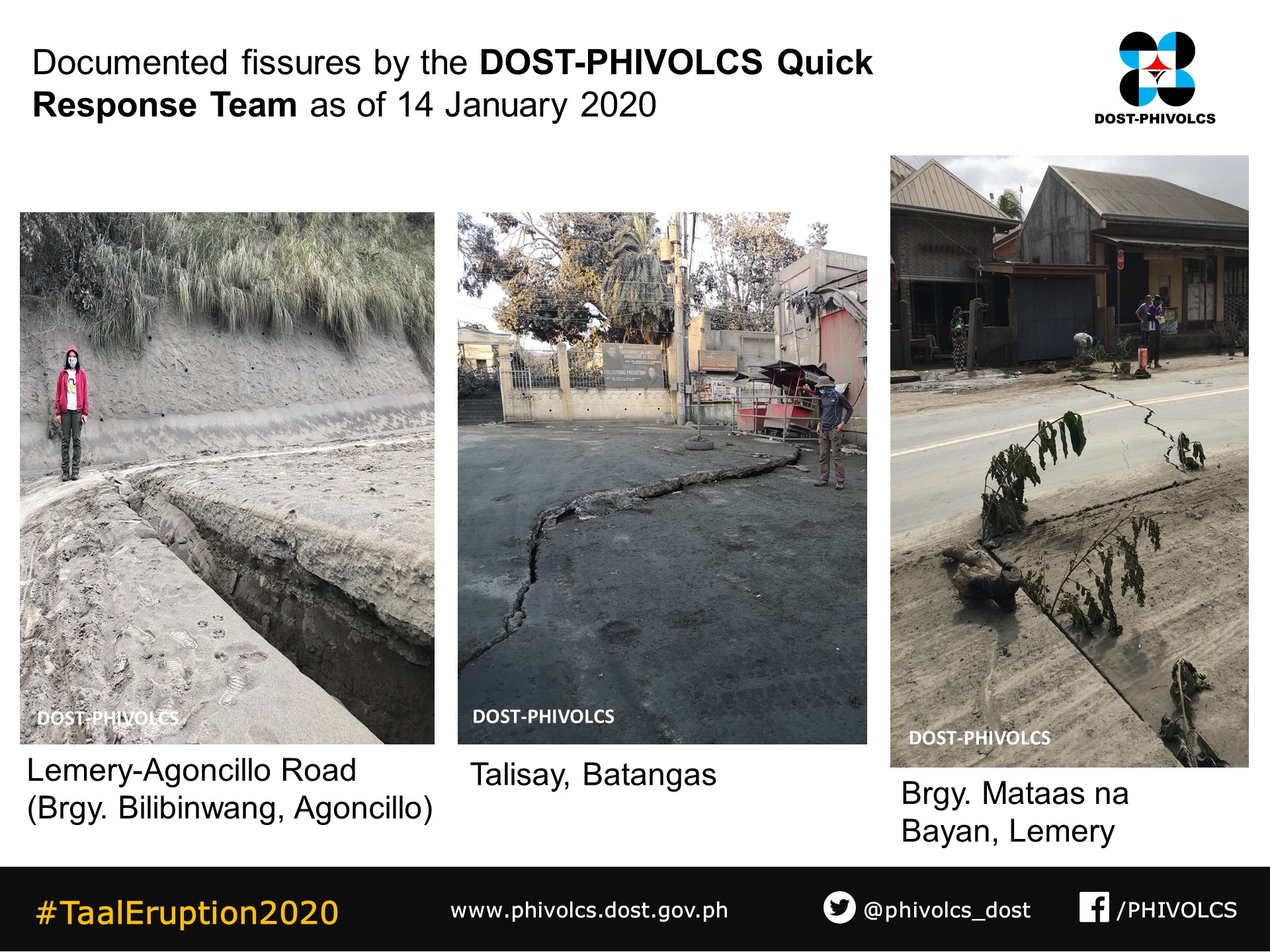
Figure 5. Soil fracturing in the southwest and northeast areas of Lake Taal, observed by PHIVOLCS staff on January 14.
Despite the sharp escalation in eruptive activity between January 12 and 13 and the current uncertainty about the evolution of the phenomena in progress, the Taal eruption was not entirely by surprise. By examining the data acquired by the surveillance networks before it starts, we see that:
Seismicity: in the long term, from March 28, 2019, the seismic activity experienced a gradual increase. In the short term, the first phreatic eruption was anticipated by a seismic swarm that had started 2 hours earlier;
Deformations: GPS data and geodetic measurements confirm an inflation (swelling) of the volcanic building between November 2018 and March 2019;
Geochemistry: an increase in the concentration of dissolved CO2 in the waters of the main crater lake observed since February 2019 indicates a slight increase in the entry of CO2 from the underlying hydrothermal system (research conducted by Alain Bernard and Corentin Caudron, du G-Time laboratory at ULB University, Belgium).
However, in the last Bulletin on the state of activity of Taal, published on the morning of January 12, the PHIVOLCS had declared that a dangerous eruption is not imminent « . The evolution of the phenomena, from the first phreatic explosions to the full explosive eruption (presumably of a subplinian nature) was therefore extremely rapid, therefore effective management of the crisis by the PHIVOLCS, which enabled the evacuation of all the people (including several tourists) present on the island, is to be appreciated.
The heavy fallout of pyroclastic materials, particularly in the regions north of the Taal, has caused damage to agriculture and housing (Figure 6). For several hours, the airport in the capital of the Philippines, Manila, was closed.
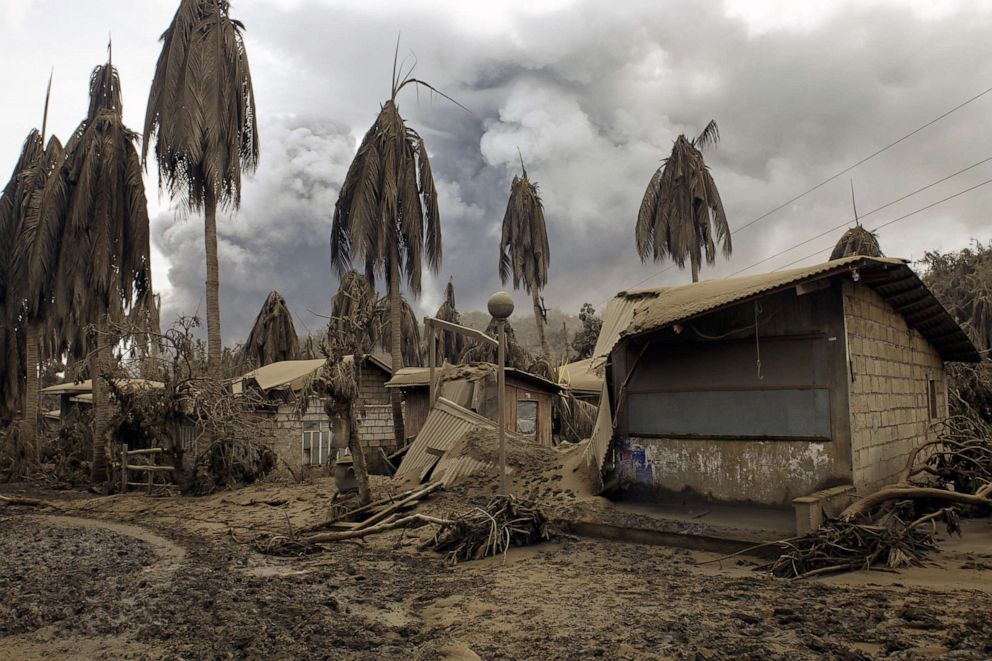
Figure 6. Damage caused by fallout of pyroclastic materials in the village of Boso Boso, several tens of kilometers north of the Taal volcano, January 13, 2020. Photo by Jes Aznar (New York Times).
Taal is the second most active volcano in the Philippines after Mayon, at the extreme south-east of Luzon. Although the current activity took place after 42 years of volcanic rest, it still represents « normal » behavior of the volcano. Past Taal eruptions have always been violent and explosive. The most powerful historic eruption, which occurred between May and November 1754, killed dozens, while the most lethal eruption was that of January 30, 1911, an event in which pyroclastic flows left 1335 people dead on Taal Island.
On September 28, 1965, the Taal woke up suddenly, after 54 years of rest, with a basalt lava fountain activity from a mouth near Monte Tabaro, located southwest of the main crater lake. The low altitude and proximity to Lake Taal caused the new crater to flood, which triggered violent phreatomagmatic activity accompanied by pyroclastic flows that killed 190 people (Figure 7). After 3 days of eruption, an island with a lake inside formed in the new crater of Monte Tabaro. On July 5, 1966, this crater was reactivated, with the creation inside a pyroclastic cone, in turn filled by a new crater lake.
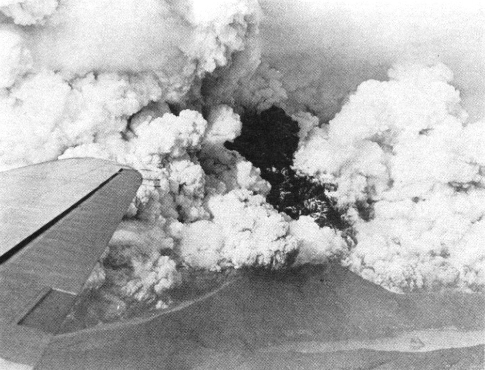
Figure 7. Aerial photo of the extremely violent pheatomagmatic activity that occurred during the September 28, 1965 eruption, with pyroclastic flows extending to the right and left. American Navy photo, published in the journal Science (see references at the end of the article).
In 1968, eruptive activity was transformed into effusive, for the first time in the recent history of Taal. On February 2, 1968, a lava flow was born from the tuff cone of 1966, which quickly overflowed advancing towards the coast of the volcanic island of Taal. The effusive eruption ended on April 2, 1968, but on October 29, 1969 the effusive and Strombolian activity started again and ended on December 10. Finally, very little phreatic activity occurred between November 9 and 12, 1970.
In 1976, from September 3 to mid-October, the Taal went through a period of groundwater activity generated by various eruptive vents in the 1965-1970 eruption zone. On October 3, 1977, small phreatic eruptions arose from the larger eruptive mouth, formed in 1976.
None of the eruptions subsequent to that of 1965 caused human casualties, since the island was uninhabited, at least until 1976. A recent census, carried out in 2010, revealed the presence of approximately 3700 inhabitants on the island, even if, according to PHIVOLCS, residence on the island was strongly discouraged.
Given the historical activity of Taal, the development of the current activity is very uncertain – it could last for months or even years (as in 1754 and 1965-1977), but it could also be already in its final phase. . The activity is continuously monitored by the PHIVOLCS, which has a network of modern tools installed throughout the volcanic complex (Figure 8).
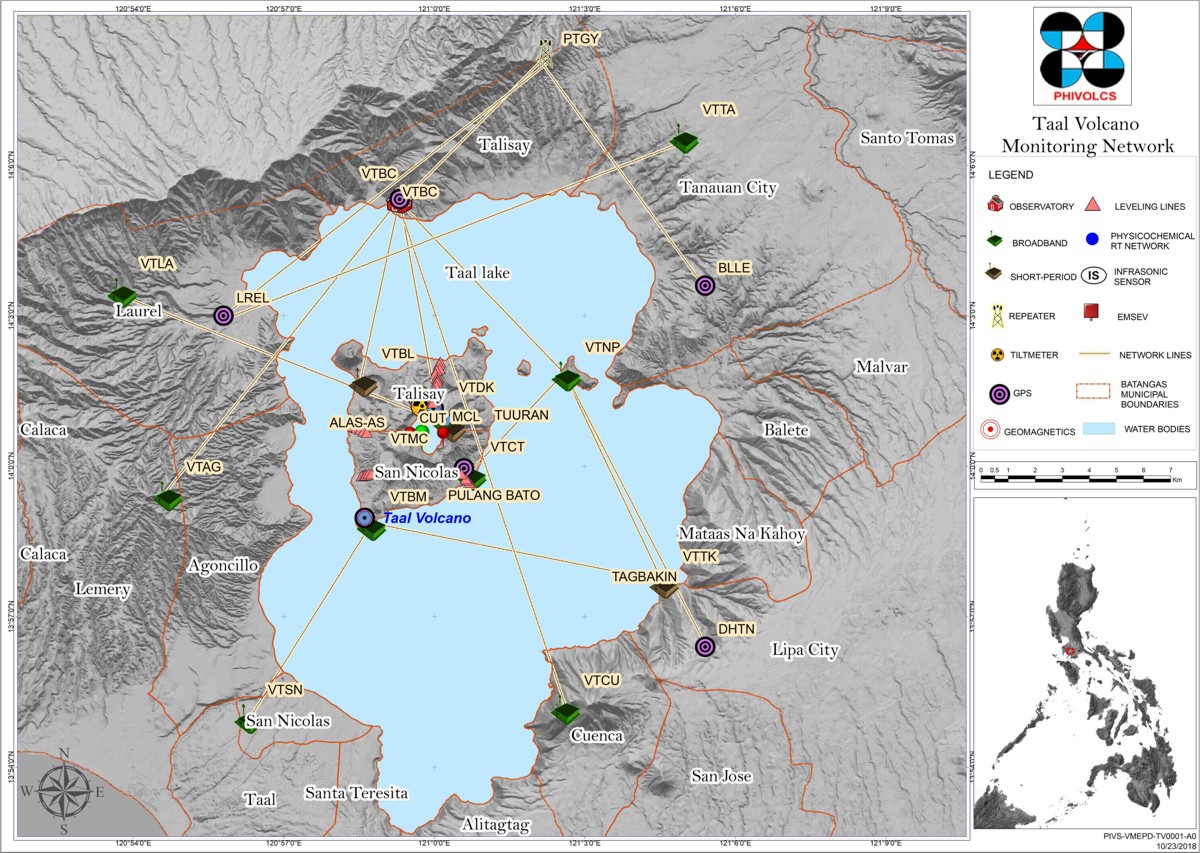
Figure 8. Map of the Taal volcano monitoring network of the Philippines Volcanological Observatory, PHIVOLCS (before the eruption of January 12, 2020).
References :
Moore, J.G., Nakamura, K., Alcaraz, A. (1966). The 1965 eruption of the Taal volcano. Science, vol. 151, p. 955-960.
PHIVOLCS (Philippine Institute of Volcanology and Seismology) website: https://www.phivolcs.dost.gov.ph/index.php
Worcester, D.C. (1912). Taal volcano and its recent destructive eruption. National Geographic, vol. 23, p. 313-367.
Source : INGV / Dmitri Rouwet / Boris Behncke.
Read the article : https://ingvvulcani.com/2020/01/15/il-fragoroso-risveglio-del-vulcano-taal/?fbclid=IwAR341lBoI3mnPDlGJqNwTfRgjGOlZD4SGQEQ32G_uwx-HLba8RouPK9PPKQ