January 16 , 2020 .
Philippines , Taal :
ERUPTION UPDATE FOR TAAL VOLCANO ALERT LEVEL 4 (HAZARDOUS ERUPTION IMMINENT) 15 JANUARY 2020 05:00 PM
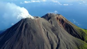
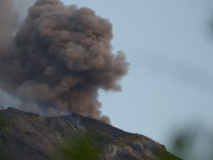
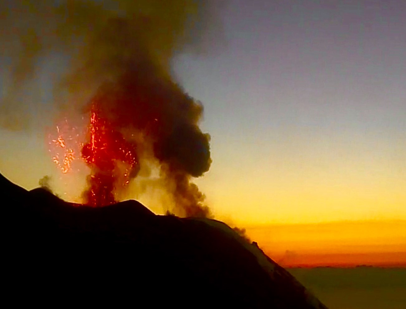
Taal Volcano’s eruption has been characterized by continuous magmatic and hydrovolcanic activity that generated 700-meter tall dark gray steam-laden plumes that drifted to the general southwest.
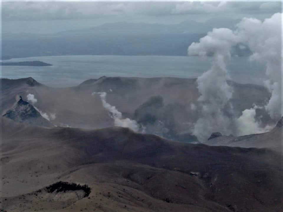
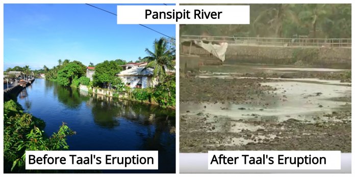
In addition to the previously identified fissures in Lemery (Sinisian, Mahabang Dahilig, Dayapan, Palanas, Sangalang, Poblacion, Mataas na Bayan), Agoncillo (Pansipit, Bilibinwang), Talisay (Poblacion 1, Poblacion 2, Poblacion 3, Poblacion 5) and San Nicolas (Poblacion), new fissures were observed in Sambal Ibaba, Lemery. Drying up of portions of Pansipit River has also been observed. Furthermore, newly acquired satellite images would show that the Main Crater Lake (MCL) has been drained and new vent craters have been formed inside the Main Crater and on the north flank of the volcano.
The Philippine Seismic Network plotted a total of five hundred twenty (520) volcanic earthquakes since 1:00 PM, January 12, 2020. One hundred sixty-nine (169) of these were felt with intensities ranging from Intensity I – V. Since 5:00 AM to 4:00 PM today, there were fifty-three (53) volcanic earthquakes plotted and twelve (12) of which were felt with intensities ranging from Intensity I – III. Such intense seismic activity probably signifies continuous magmatic intrusion beneath the Taal edifice, which may lead to further eruptive activity.
TAAL VOLCANO BULLETIN: 16 January 2020 8:00 A.M.
At 6:17 and 6:21 AM today, Taal Volcano erupted short-lived dark gray ash plumes 500 meters and 800 meters high, respectively, that dispersed ash southwest to west of the Main Crater. Activity in the past 24 hours has generally waned to weak emission of steam-laden plumes 700 meters high that dispersed ash to the southwest.
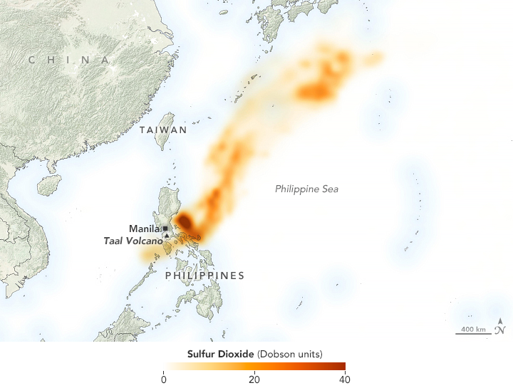
Sulfur dioxide concentrations – detected on 13.01.2020 by Ozone Mapping Profiler Suite (OMPS) on board the NOAA-NASA Suomi-NPP satellite.
The Philippine Seismic Network plotted a total of five hundred sixty-six (566) volcanic earthquakes since 1:00 PM, January 12, 2020. One hundred seventy-two (172) of these registered at magnitudes M1.2 – M4.1 and were felt at Intensities I – V. Since 5:00 AM on January 15, 2020 until 5:00 AM today, there were one-hundred three (103) volcanic earthquakes plotted, fourteen (14) of these registered at magnitudes M1.4 -M4.0 and were felt at Intensities I – III. Such intense seismic activity likely signifies continuous magmatic intrusion beneath the Taal edifice, which may lead to further eruptive activity.
Sulfur dioxide (SO2) emission was measured at an average of 4186 tonnes/day on 15 January 2020.
Alert Level 4 still remains in effect over Taal Volcano. This means that hazardous explosive eruption is possible within hours to days. DOST-PHIVOLCS strongly reiterates total evacuation of Taal Volcano Island and high-risk areas as identified in the hazard maps within the 14-km radius from Taal Main Crater and along the Pansipit River Valley where fissuring has been observed. Residents around Taal Volcano are advised to guard against the effects of heavy and prolonged ashfall. Civil aviation authorities must advise pilots to avoid the airspace around Taal Volcano as airborne ash and ballistic fragments from the eruption column pose hazards to aircraft.
DOST-PHIVOLCS is continually monitoring the eruption and will update all stakeholders of further developments.
Source : Phivolcs .
Photos : Rafi Tima , Philippineslifestyle.com ,
Italy , Stromboli :
Weekly bulletin from 06/01/2020 to 12/01/2020 (date of issue 14/01/2020)
SUMMARY OF THE STATUS OF THE ACTIVITY.
In light of the monitoring data, it is underlined:
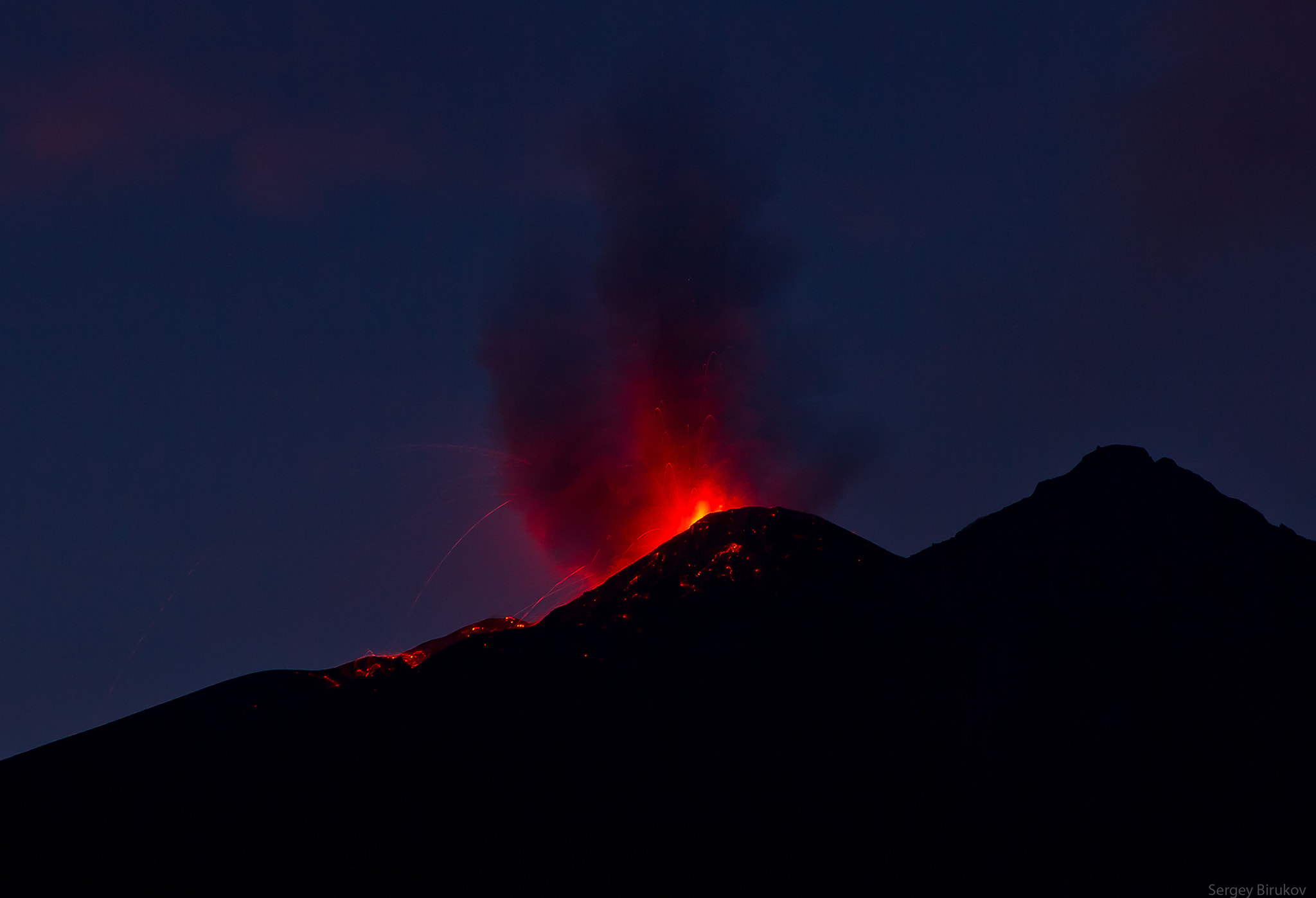
1) VOLCANOLOGICAL OBSERVATIONS: During this period, normal explosive activity of the strombolian type was observed, accompanied by degassing and splashing activities. The hourly frequency of explosions fluctuated between medium-high values (16 events / h on January 8) and very high values (30 events / h on January 11). The intensity of the explosions was mainly medium-low in the area of the North crater and medium in the area of the Center-South crater.
2) SEISMOLOGY: The seismological parameters do not present significant variations.
4) DEFORMATIONS: No change to report.
5) GEOCHEMISTRY: The flow of SO2 is at an average level. No update is available on the isotopic ratio of helium in the aquifer. The last values (sampling of 12/19/2019) are medium-low. The CO2 / SO2 ratio in the plume, since the last update of 05/01/2020, is at a medium-high value.
The analysis of the images recorded by the cameras placed at an altitude of 400m, at an altitude of 190m and at Punta dei Corvi made it possible to characterize the eruptive activity of Stromboli. During the period under review, the explosive activity was mainly produced by at least 3 (three) eruptive vents located in the area of the North crater and by at least 3 (three) eruptive vents located in the area of the Center-South crater . All the vents are located inside the depression which occupies the crater terrace.
In the North zone, the explosions were mainly low (less than 80 m high) and medium (less than 150 m high), sometimes high (greater than 150 m high) emitting coarse materials (lapilli and bombs). In many explosions, the fallout covered the outer slopes of the area overlooking the Sciara del fuoco and a few blocks rolled for a few hundred meters before stopping along the Sciara. Splashes were observed from the mouths located in the southern part of the North zone, sometimes intense on January 6 and 10, 2020. The average frequency of explosions in the North zone varied between 3 and 22 events / h. The explosive activity in the Center-South zone caused explosions of coarse material mixed with fine ash, of medium intensity (less than 150 m high). In some explosions, the products fell into the upper part of the Sciara. The frequency of explosions in the Center-South zone varied between 7 and 16 events / h … / …
The amplitude of the volcanic tremor showed generally medium-low values.
Source : INGV.
Read the article: file:///C:/Users/Utilisateur/AppData/Local/Packages/Microsoft.MicrosoftEdge_8wekyb3d8bbwe/TempState/Downloads/BollettinoStromboli20200114%20(1).pdf
Indonesia , Karangetang :
2.781°N, 125.407°E
Elevation 1797 m
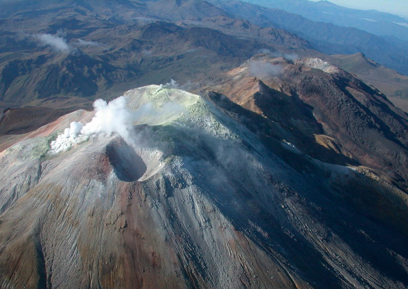
PVMBG reported that during 6-12 January lava continued to effuse from Karangetang’s Main Crater (S), traveling as far as 1.8 km down the Nanitu, Pangi, and Sense drainages on the SW and W flanks. Sometimes dense white plumes rose 100-400 m above the summit. Incandescence from both summit craters was visible at night. The Alert Level remained at 2 (on a scale of 1-4).
Karangetang (Api Siau) volcano lies at the northern end of the island of Siau, about 125 km NNE of the NE-most point of Sulawesi island. The stratovolcano contains five summit craters along a N-S line. It is one of Indonesia’s most active volcanoes, with more than 40 eruptions recorded since 1675 and many additional small eruptions that were not documented in the historical record (Catalog of Active Volcanoes of the World: Neumann van Padang, 1951). Twentieth-century eruptions have included frequent explosive activity sometimes accompanied by pyroclastic flows and lahars. Lava dome growth has occurred in the summit craters; collapse of lava flow fronts have produced pyroclastic flows.
Source: Pusat Vulkanologi et Mitigasi Bencana Geologi (PVMBG ) GVP .
Photo : Irfan FeykOe / Facebook .
Colombia , Cumbal :
Cumbal volcanic complex weekly activity bulletin
The activity of the Cumbal volcanic complex continues at the level: YELLOW LEVEL ■ (III): CHANGES IN THE BEHAVIOR OF VOLCANIC ACTIVITY.
Following the activity of the CUMBAL VOLCANIC COMPLEX, the COLOMBIAN GEOLOGICAL SERVICE (SGC) reports that:
For the period from January 7 to 13, 2020, seismic occurrence levels similar to those reported in previous weeks were maintained, with an increase from the previous evaluated period, but in energy levels low. The predominant seismicity was associated with the movement of fluids from a transient source in the volcanic system. Regarding the fracture type seismicity, it recorded a low energy level, located mainly in the vicinity of the La Plazuela crater (northeast of the Cumbal volcanic complex) and at surface levels, with amplitudes ranging up to 1.2 degrees on the Richter scale.
Thanks to web cameras and satellite images, it was possible during the week to record gas emissions, mainly from the crater of La Plazuela, El Verde and other fields of fumaroles of the volcanic building of Cumbal , Northeast of the volcanic complex; and fumarole fields on the volcanic building of Mundo Nuevo (southwest of the volcanic complex), mainly, Las Bandas, Rastrojo Alto and Boca Vieja. The emission columns were white, the height and direction varying according to the action of the winds.
The other volcanic monitoring parameters did not show significant variations.
Source : SGC.