October 09 , 2023.
Philippines , Mayon :
MAYON VOLCANO BULLETIN 09 October 2023 8:00 AM
In the past 24-hour period, the Mayon Volcano Network recorded five (5) volcanic earthquakes, two (2) pyroclastic density current event, and one hundred sixty-seven (167) rockfall events. The lava flows have maintained their advances to approximately 3.4 kilometers in Bonga (southeastern), 2.8 kilometers in Mi-isi (south), and 1.1 kilometers in Basud (eastern) Gullies. Rockfalls and PDCs generated by collapses of the lava flow margins as well as of the summit dome deposited debris still within four (4) kilometers of the crater.
Volcanic sulfur dioxide (SO2) emission averaged 1,063 tonnes/day on 8 October 2023. Short-term observations from electronic tilt and GPS monitoring indicate inflation of the northwestern upper and middle slopes since late July 2023 and October 2023, respectively. Longer-term ground deformation parameters from EDM, precise leveling, continuous GPS, and electronic tilt monitoring indicate that Mayon is still generally inflated relative to baseline levels.
Alert Level 3 is maintained over Mayon Volcano, which means that it is currently in a relatively high level of unrest, and hazardous eruption within weeks or even days could still be possible.
Source : Phivolcs
Photo :Archive, Author unknown.
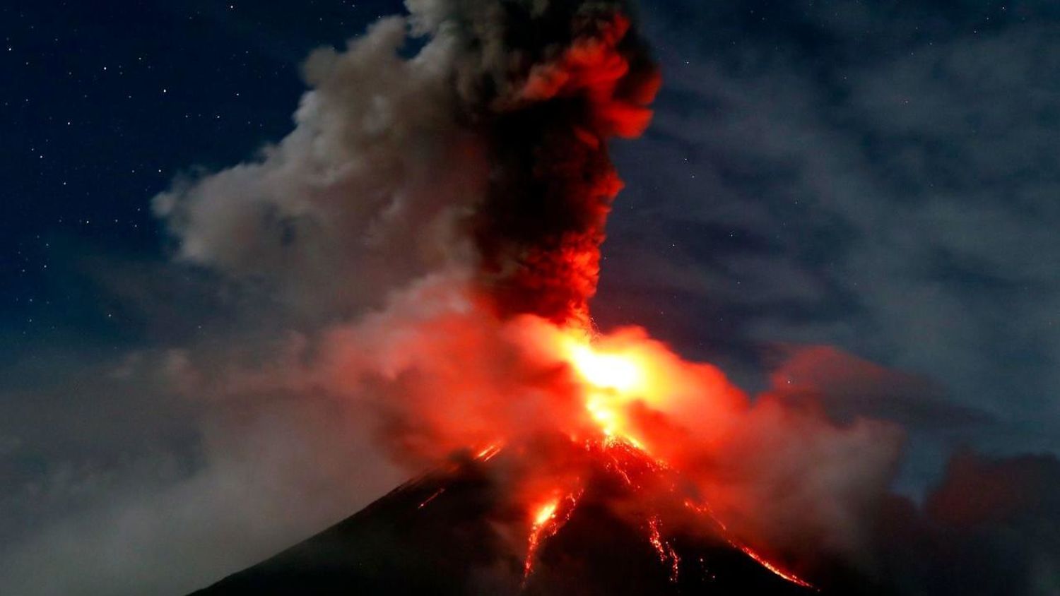
Italy , Stromboli :
Communiqué on the activity of Stromboli, October 08, 2023, 22:08 (20:08 UTC).
The National Institute of Geophysics and Volcanology, Osservatorio Etneo, communicates that from 7:30 p.m. UTC, images from video surveillance cameras show an overflow of lava fueled by the intense splashing activity in the North Crater area. The overflow, for the moment, remains confined to the upper part of the Sciara del Fuoco. Strombolian activity continues in both the North and South-Central crater areas.

From a seismic point of view, from 7:15 p.m. UTC, the average amplitude of the volcanic tremor reached high values. No significant changes were reported in the frequency of occurrence and amplitude of explosion earthquakes.
The deformation data from the inclinometer and GNSS networks do not show significant variations.
Further updates will be communicated shortly.
Source : INGV.
Photo : Stromboli stati d’animo.
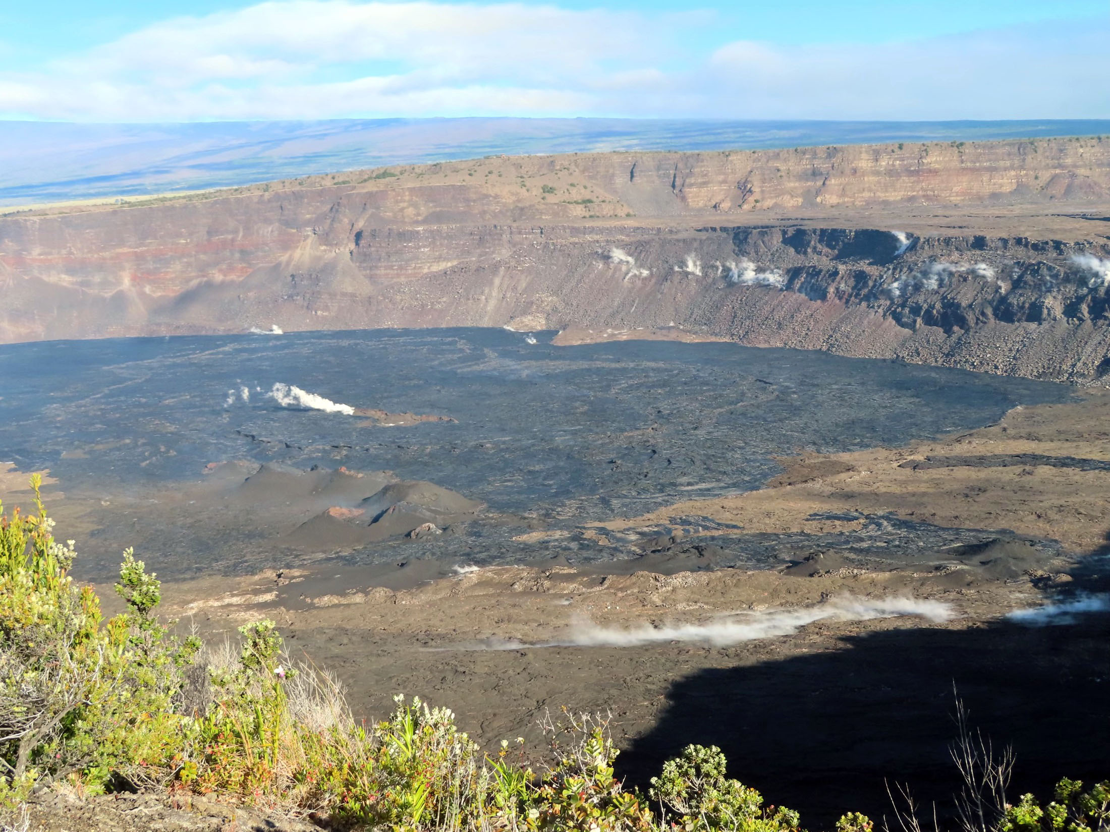
Chile , Laguna del Maule :
Seismology
The seismological activity of the period was characterized by the recording of:
1634 seismic events of type VT, associated with the fracturing of rocks (Volcano-Tectonics). The most energetic earthquake had a Local Magnitude (ML) value equal to 2.1, located 6.8 km south-southwest (SSW) of the center of the lagoon, at a depth of 6.8 km per compared to the average height of the lagoon.
1 LP type seismic event, associated with fluid dynamics inside the volcanic system (Long Period). The earthquake presented a reduced displacement (RD) value of 0.9 cm2.
Fluid geochemistry
No anomalies have been reported in the emissions of sulfur dioxide (SO2) into the atmosphere in the area near the volcanic complex, according to data published by the Tropospheric Monitoring Instrument (TROPOMI) and the Ozone Monitoring Instrument (OMI) .

Geodesy
The data obtained by the geodetic network for the period were characterized by:
– Monitoring line with average rates similar to historical values, observed in the volcanic complex, adjusting a maximum of 1.2 cm/month for the available line.
– Vertical deformation rates similar to previous periods, with some minor variations, reaching a relative maximum of 1.6 cm/month.
– Thanks to satellite radar interferometry, no signal associated with deformation due to the heavy presence of snow in the area was detected.
Instrumental records continue to show the presence of volcano-tectonic seismicity with energies that exceed usual levels for this volcanic complex.
As this activity develops, the location of the epicenters continues mainly in the South-East (SE) sector of the lagoon. The volcanic deformation process remains active with uplift rates similar to those historically recorded according to geodetic network data. From the images allowing the assessment of visual aspects at surface level, no changes associated with volcanic activity are observed. The energetic volcanic activity and the presence of the CO2 anomaly allow us to deduce that the volcanic system always remains above its base threshold, therefore it remains:
YELLOW TECHNICAL ALERT: Changes in the behavior of volcanic activity
Source : Sernageomin
Photo : Dr Katie Keranen.
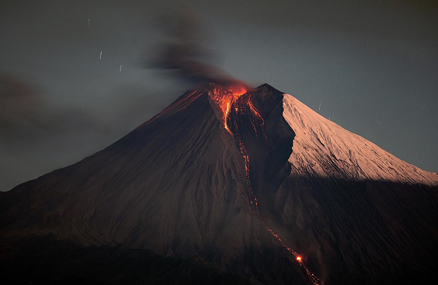
Ecuador , Sangay :
DAILY REPORT ON THE STATE OF THE SANGAY VOLCANO, Sunday October 8, 2023.
Information Geophysical Institute – EPN.
Surface activity level: High, Surface trend: No changes
Internal activity level: High, Internal trend: No changes
Seismicity: From October 7, 2023, 11:00 a.m. to October 8, 2023, 11:00 a.m.:
The number of seismic events recorded at the reference station over the past 24 hours is shown below. The level of seismic activity of the volcano remains high.
Explosion Event (EXP): 501
Precipitation/Lahars:
Rains were recorded in the volcano area without generating mudslides or debris. *In the event of heavy rains, these could remobilize the accumulated materials, generating mud and debris flows which would descend the sides of the volcano and flow into adjacent rivers.
Emissions/ash column:
According to the surveillance camera system, several gas and ash emissions were observed with heights between 1,100 and 2,000 meters above the level of the crater in the West and North-Northwest directions. On the other hand, the VAAC in Washington reported emissions of gas and ash visualized by satellite with a height between 866 and 2390 meters above the level of the crater in a West and North-West direction. Additionally, today until 10:00 TL, according to reports from the Risk Management Secretariat, light ash falls were confirmed in the municipalities of Cebadas and Guamote belonging to the canton of Guamote, province of Chimborazo.
Other monitoring parameters:
The MIROVA-MODIS satellite system recorded 2 moderate thermal anomalies, the MIROVA-VIIRS system recorded 2 moderate thermal anomalies and 1 weak thermal anomaly, during the last 24 hours. In addition, the FIRMS satellite system recorded 3 thermal anomalies in the last 12 hours.
Observation:
In the early morning today, several episodes of emissions of incandescent materials were observed thanks to the network of surveillance cameras which went down the South-East ravine to
1800 meters below the level of the crater. At the time of closing this report, the volcano is cloudy
Alert level: Orange.
Source : IGEPN.
Photo : Eqphos_fotografía
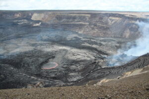
Hawaii , Kilauea :
Sunday, October 8, 2023, 8:29 AM HST (Sunday, October 8, 2023, 18:29 UTC)
19°25’16 » N 155°17’13 » W,
Summit Elevation 4091 ft (1247 m)
Current Volcano Alert Level: ADVISORY
Current Aviation Color Code: YELLOW
Activity Summary:
Kīlauea volcano is not erupting. The area just south of Kīlauea’s summit is showing signs of unrest. No unusual activity has been noted along Kīlauea’s East Rift Zone or Southwest Rift Zone.
Summit Observations:
Slight inflationary tilt was recorded yesterday in the area just south of the summit caldera, which leveled off around 7:30 p.m. and showed no appreciable changes since then. Inflation at the summit of Kīlauea remains at about its highest level in over 5 years and has nearly returned to the level seen just before the last eruption on September 10th. Elevated seismicity beneath Kīlauea summit region, which began October 4, increased again around 8:00 p.m. last night after about 18 hours of moderate to low earthquake counts. Over the past 24 hours approximately 100 earthquakes were recorded in Kīlauea summit region compared to about 170 earthquakes occuring over the previous day. Most of the earthquakes from the seismic swarm south of the caldera are at depths of around 2.5–3.5 km (1.5–2 mi) below the surface. The trend of the seismic activity parallels, but is slightly south of the December 1974 eruption vents. Sulfur dioxide (SO2) emission rates remain low and were measured at a rate of about 100 tonnes per day on October 6.
Source : HVO.
Photo : USGS / J. Chang.