February 23 , 2021 .
Peru , Sabancaya :
Analysis period: from February 15, 2021 to February 21, 2021, Arequipa, February 22, 2021.
Alert level: ORANGE
The Geophysical Institute of Peru (IGP) reports that the eruptive activity of the Sabancaya volcano remains at moderate levels, that is, with the recording of an average of 71 daily explosions, with columns of ash and gas up to 3.2 km altitude above the summit of the volcano and their subsequent dispersion. Therefore, for the following days, no significant change is expected in the eruptive activity.
The IGP recorded and analyzed the occurrence of 1984 earthquakes of volcanic origin, associated with the circulation of magmatic fluids inside the Sabancaya volcano. An average of 71 explosions was recorded daily. During this period, Volcano-Tectonic (VT) earthquakes associated with rock fracturing were located mainly in the North-East of Sabancaya and presented magnitudes between M2.2 and M3.5.
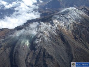
The monitoring of the deformation of the volcanic structure using GNSS techniques (processed with fast orbits) does not present any significant anomalies. However, in general, an inflation process has been observed in the northern sector (around the Hualca Hualca volcano). Visual surveillance made it possible to identify columns of gas and ash up to 3.2 km altitude above the summit of the volcano, which were scattered towards the South-West, South, South-East, East and Northwest of Sabancaya. Satellite monitoring identified the presence of 10 thermal alerts, with values between 1 and 52 MW which are associated with the presence of a lava dome on the surface of the volcano’s crater.
RECOMMENDATIONS
• Keep the volcanic alert level in orange.
• Do not approach within a radius of less than 12 km from the crater.
Source : IGP.
Photo : archive Ingemmet.
Chile , Laguna del Maule :
CHANGE OF ALERT LEVEL OF THE LAGUNA DEL MAULE VOLCANIC COMPLEX
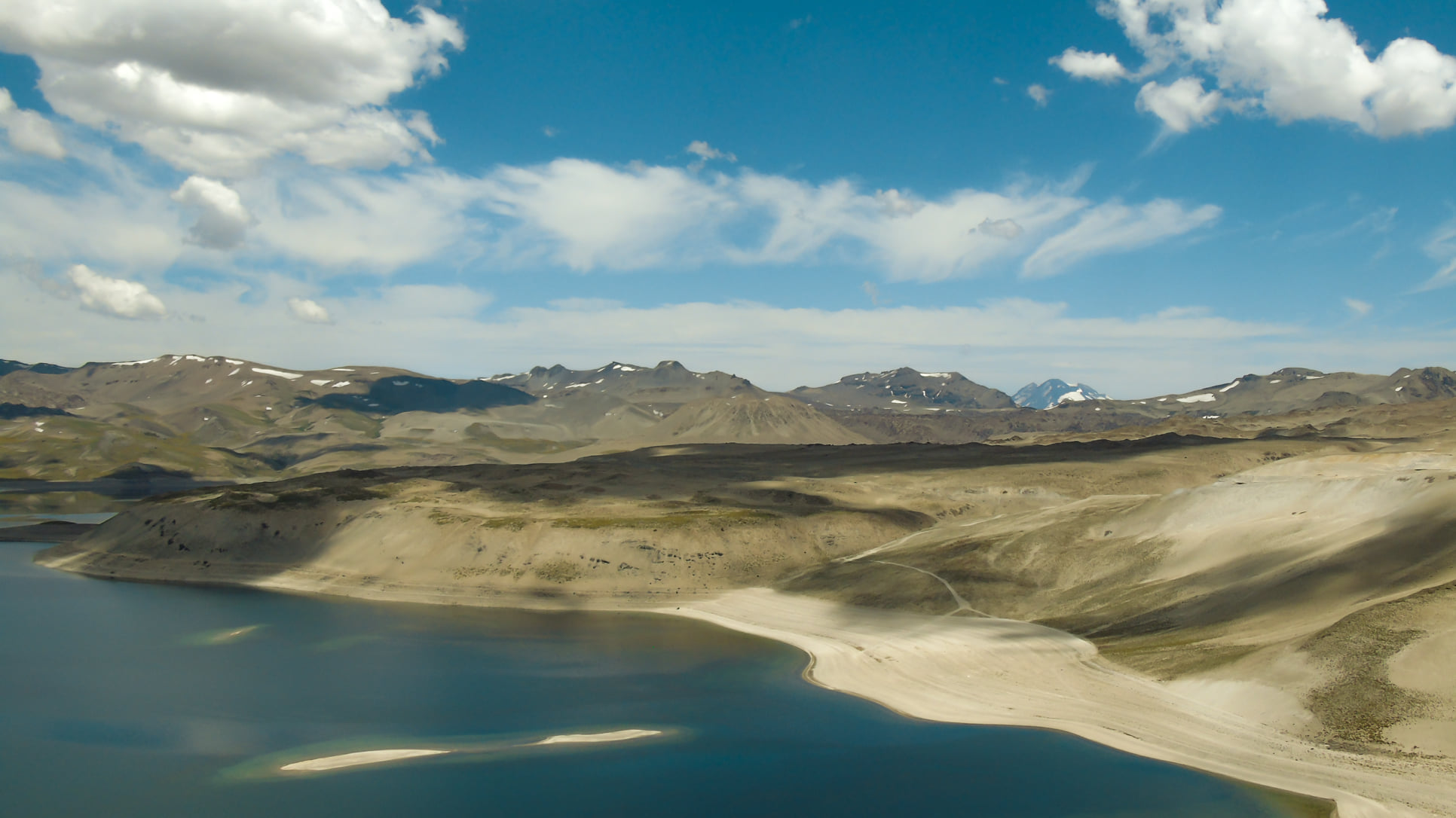
During the past two weeks, the Southern Andes Volcanological Observatory (OVDAS) has detected 533 volcano-tectonic (VT) seismic events, associated with a rock fracture in the volcanic system, and deformation rates of 2.3 cm / month, above average since 2012. Therefore, SERNAGEOMIN decided to change the technical alert level from green to YELLOW, which was reported in the volcanic activity report for the last fortnight.
In addition, it has been observed that VT-type events were persistent over time and increased in magnitude. Their locations are concentrated in the Las Nieblas sector, south of the lagoon, a place where carbon dioxide (CO2) anomalies have been detected since 2019.
Finally, a hazard zoning with a radius of 2 km is reported around the site of the CO2 anomaly, where it is recommended not to access.
In this regard, Alfonso Domeyko, national director of Sernageomin, stressed that “there is no evidence yet that there could be a major surface manifestation in the volcanic complex, and at the same time our Geology management professionals monitor La Laguna del Maule in the field and remotely, 24 hours a day, 7 days a week, just like the most active volcanoes in the country ”.
He added that « the earthquakes of the last week were detected, although in less quantity than those observed last June, with a greater magnitude, which shows a more energetic process. » He concluded that “this seismic process is distinguished by the persistence of its occurrence and its localization which, added to the gas anomaly observed and the constant deformation, allow to consider that the volcanic complex is above its level of based ».
Photo : Franco Vera.
Italy / Sicily , Etna :
Continuation of the ETNA serial .
COMMUNICATION ON THE ACTIVITY OF ETNA, 22 February 2021, 22 21:50 (20:50 UTC).
The National Institute of Geophysics and Volcanology, Osservatorio Etneo, reports that weak Strombolian activity is underway at the Southeast Crater. The average amplitude of the volcanic tremor gradually increases while remaining at the current state at the average level.
The sources of the tremor are located under the crater of Bocca Nuova, about 2,500 m above sea level.
The infrasound signals show a slight but significant variation in both the rate of occurrence and the energy released and are mainly located in correspondence with the Southeast Crater.
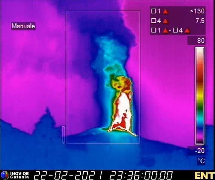
Nicolosi thermal imager, about 15 km away, reveals the true height of the lava jet which rises more than 1000 m above the crater
COMMUNICATION ON THE ACTIVITY OF ETNA, 22 February 2021, 22:27 (21:27 UTC).
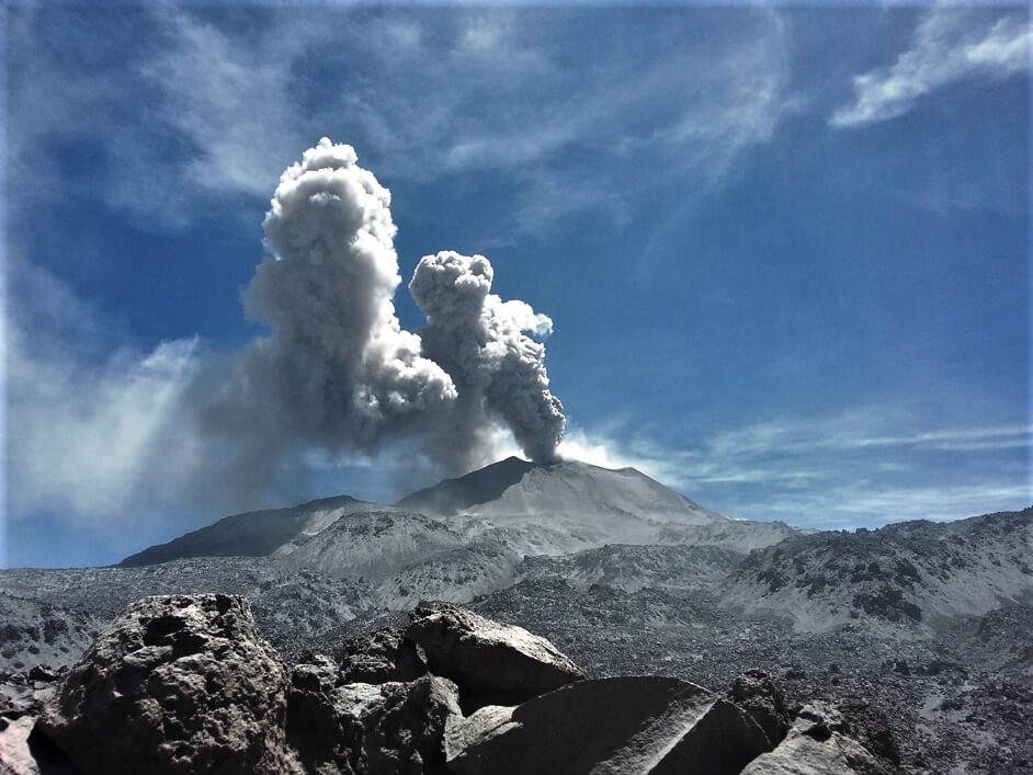
The National Institute of Geophysics and Volcanology, Osservatorio Etneo, announces that there is an increase in the frequency and intensity of Strombolian activity at the Southeast Crater, with the abundant launch of products outside the rim. from the crater. From about 2110 UTC, the average amplitude of the volcanic tremor shows a new sudden increase; currently, the amplitude is in the high level.
The source of the tremor shows a gradual displacement towards the Southeast Crater, at a depth of 2500 m above sea level.
The infrasonic activity increased dramatically with a high rate of occurrence of infrasonic transients. These are located in correspondence with the Southeast Crater.
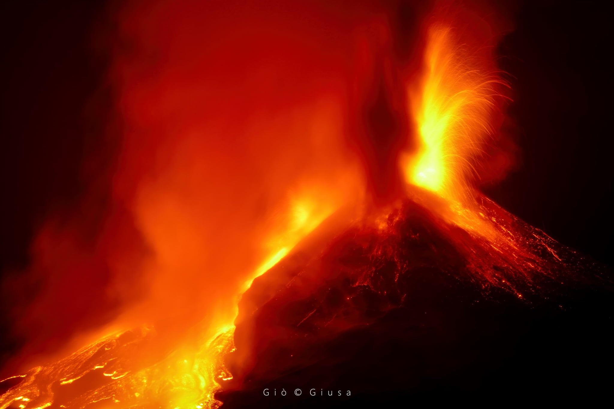
COMMUNICATION ON THE ACTIVITY OF ETNA, 22 February 2021, 23:49 (22:49 UTC).
The National Institute of Geophysics and Volcanology, Osservatorio Etneo, announces that at 22:27 UTC, a second vent has been activated inside the Southeast Crater which is producing lava fountain activity. At 22:28 UTC there was an overflow towards Valle del Bove. The lava front is currently at an altitude of about 3000 m.
The average amplitude of the volcanic tremor and the infrasound activity remain at high values.
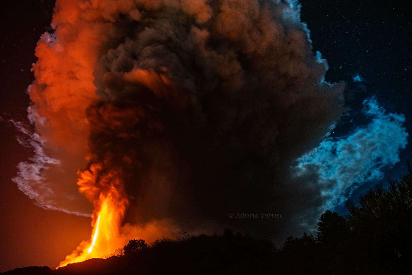
COMMUNICATION ON THE ACTIVITY OF ETNA, 23 February 2021, 01:33 (00:33 UTC).
The National Institute of Geophysics and Volcanology, Osservatorio Etneo, reports that activity around 11:30 p.m. GMT intensified further, generating jets of lava up to a thousand meters high above the Southeast Crater. This activity produced an eruptive column which rose several kilometers from the summit of Etna. During this activity, another lava overflow started from the mouth of the saddle, feeding a lava flow directed towards the southwest. As of 12:15 GMT, there was a sudden decrease in the lava fountain. The effusive activity of the two lava flows continues, overlapping the flows of the previous episodes. The explosive activity at the summit craters also continues.
The average amplitude of the volcanic tremor, after reaching its maximum value at 23:50 UTC, suffered a sudden decrease, while remaining in the upper range. The source of the tremor is located in the area of the Southeast Crater, at a depth of 2700-2800 m above sea level.
The infrasound activity shows a moderate decrease in both the rate of occurrence and the energy of the events, which are located at the Southeast Crater.
The data from the GPS network shows no significant change.
COMMUNICATION ON THE ACTIVITY OF ETNA, 23 February 2021, 05:41 (04:41 UTC).
The National Institute of Geophysics and Volcanology, Osservatorio Etneo, announces that from 03:50 GMT, there is an increase in the frequency and intensity of Strombolian activity, accompanied by emission of ash, at the Crater Southeast, with the abundant launching of products outside the rim of the crater, up to a height of about 300 m. At the same time, two small lava flows formed, one towards the Valle del Bove and the other towards the southwest.
Regarding the amplitude of the volcanic tremor, after reaching average values, after the end of the previously communicated fountain activity, from 3.50 GMT, it showed a sudden increase moving towards high values . The location of the source remains under the Southeast Crater at an altitude of about 2,800 meters above sea level. Infrasound activity after a decline phase shows a moderate recovery in both the rate of occurrence and in the energy of the events, which are located at the Southeast Crater.
Further updates will be communicated shortly.
Source : INGV.
Photos : INGV . Gio Giusa , Alberto Torrisi ( via Sherine France ).
Video : Boris Behncke.
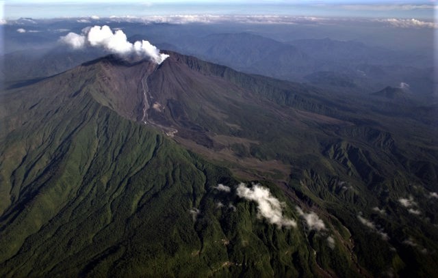
Ecuador , Reventador :
DAILY REPORT OF THE STATE OF THE REVENTADOR VOLCANO, Thursday 22 February 2021.
Information Geophysical Institute – EPN.
Surface activity level: High, Surface trend: No change.
Internal activity level: High, Internal trend: No change.
Seismicity: From February 21, 2021, 11: 00h to February 22, 2021, 11: 00h:
Explosions (EXP): 82 events
Long period type events (LP): 70
Emission tremor (TREMI): 7
Harmonic tremor (TRARM): 3
Rains / lahars: Light rains were recorded in the volcano region, which did not generate lahars.
Emission / ash column: It was observed, between the clouds, gas and ash emissions up to 1000 meters above the level of the crater, with a North-West and West direction. The Washington VAAC reported an emission of gas and ash up to 688 meters above the summit in a southerly direction.
Other monitoring parameters: No thermal alerts have been recorded in the last 24 hours.
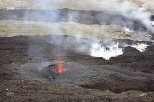
Observations: The volcano sector was partially cleared at the end of the afternoon yesterday, the rest of the time it remained cloudy. At night and early in the morning, an incandescence was observed in the crater among the clouds. In addition, for a few days, a new impulse of lava can be observed descending from the northern vent of the crater.
Alert level: Orange.
Source : IGEPN
Photo : Patricio Ramon, 2005 (Instituto Geofisca, Escuela Politecnica Nacional).