January 27 , 2021 .
Philippines , Pinatubo :
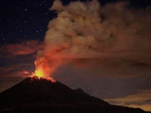
PINATUBO VOLCANO ADVISORY 27 JANUARY 2021 9:00 AM
This is to notify the public and concerned authorities of recent earthquake activity in Pinatubo Volcano.
Since 20 January 2021, the Pinatubo Volcano Network (PVN) and the Philippine Seismic Network (PSN) have detected a total of 826 imperceptible earthquakes east-northeast of Pinatubo Volcano in the vicinities of the City of Mabalacat, Pampanga. The strongest of these earthquakes occurred on 25 January at depths of 15-28 kilometers and ranged between ML1.0 and ML2.5 in magnitudes. Based on the general distribution of located events, these earthquakes were generated along a segment of the Sacobia Lineament, a fault that was last active during the post-eruption period of 1991. This development serves to remind us once again that several faults occur around the volcano and that these can generate earthquake activity that can be sometimes imperceptible and harmless but that can also sometimes be damaging. On 22 April 2019, a M6.1 earthquake on the southern foot slopes of Pinatubo Volcano shook the Central Luzon region and caused fatalities and substantial damages to buildings, roads and other structures.

DOST-PHIVOLCS would like to assure the public that Pinatubo Volcano remains at Alert Level 0 and remains in quiescent condition. Although there is currently no threat from the above recent earthquake activity, communities and local government units surrounding the volcano, nonetheless, have to be reminded to be always prepared for both earthquake and volcanic hazards and to build on the lessons of what they have experienced in the past years. DOST-PHIVOLCS continues to strengthen its monitoring of the volcano with ongoing upgrades to the PVN and upcoming geochemical surveys of the Pinatubo crater lake.
DOST-PHIVOLCS is closely monitoring the volcano’s condition and any new development will be relayed to all concerned.
Source : Phivolcs .
Photo : Lemuel Salibio / Wikipedia .
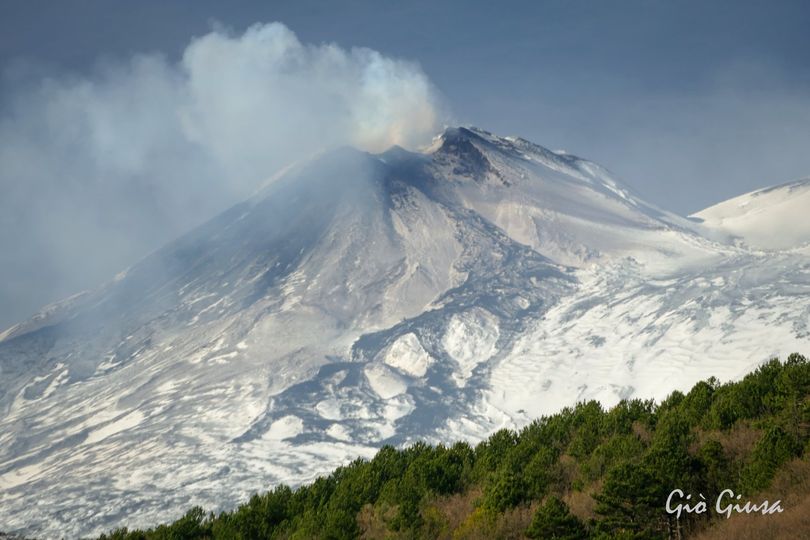
Italy / Sicily , Etna :
Weekly bulletin, from January 18, 2021 to January 24, 2021. (issue date January 26, 2021)
SUMMARY OF THE STATE OF ACTIVITY
In the light of surveillance data, it is highlighted:
1) VOLCANOLOGICAL OBSERVATIONS: Strombolian activity of variable intensity, episode of lava fountains, emissions of volcanic ash, lava overflow from the Southeast crater. Intra-crater Strombolian activity at the Northeast crater, at the crater of Bocca Nuova and at the crater of Voragine with occasional and diluted emissions of volcanic ash.
2) SEISMOLOGY: Increased rate of occurrence of fracturing earthquakes. Amplitude of the tremor between medium-high values. Episodes of sudden increases in the amplitude of the tremor associated with the lava overflow produced by the Southeast crater.
3) INFRASON: moderate infrasound activity.
4) DEFORMATIONS: No significant variation to report for the deformations measured by the networks of inclination and GNSS sensors, with the exception of the inclinometric station of the « Cratère del Piano » which recorded a variation of approximately 1 microradian on the two components of the inclinometric sensor, at the same time as the lava fountain episode of January 18.
5) GEOCHEMISTRY: SO2 flux: medium-high level
HCl flux occurs at a medium-high level.
The CO2 flux from the soil is at average levels.
The partial pressure of dissolved CO2 does not show significant changes.
There are no updates for the C / S report.
The helium isotope ratio is at average values (last update 08/01/2021).
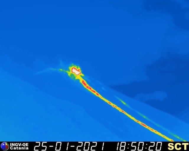
6) SATELLITE OBSERVATIONS: The thermal activity in the summit area is at a moderate level.
VOLCANOLOGICAL OBSERVATIONS
The monitoring of the volcanic activity of Etna, during the week in question, was carried out by analyzing the images of the network of surveillance cameras INGV, Osservatorio Etneo (INGV-OE) and through the observations made by the INGV-OE staff on January 18 and 19. Due to unfavorable weather conditions, it was not possible to observe continuous volcanic activity.
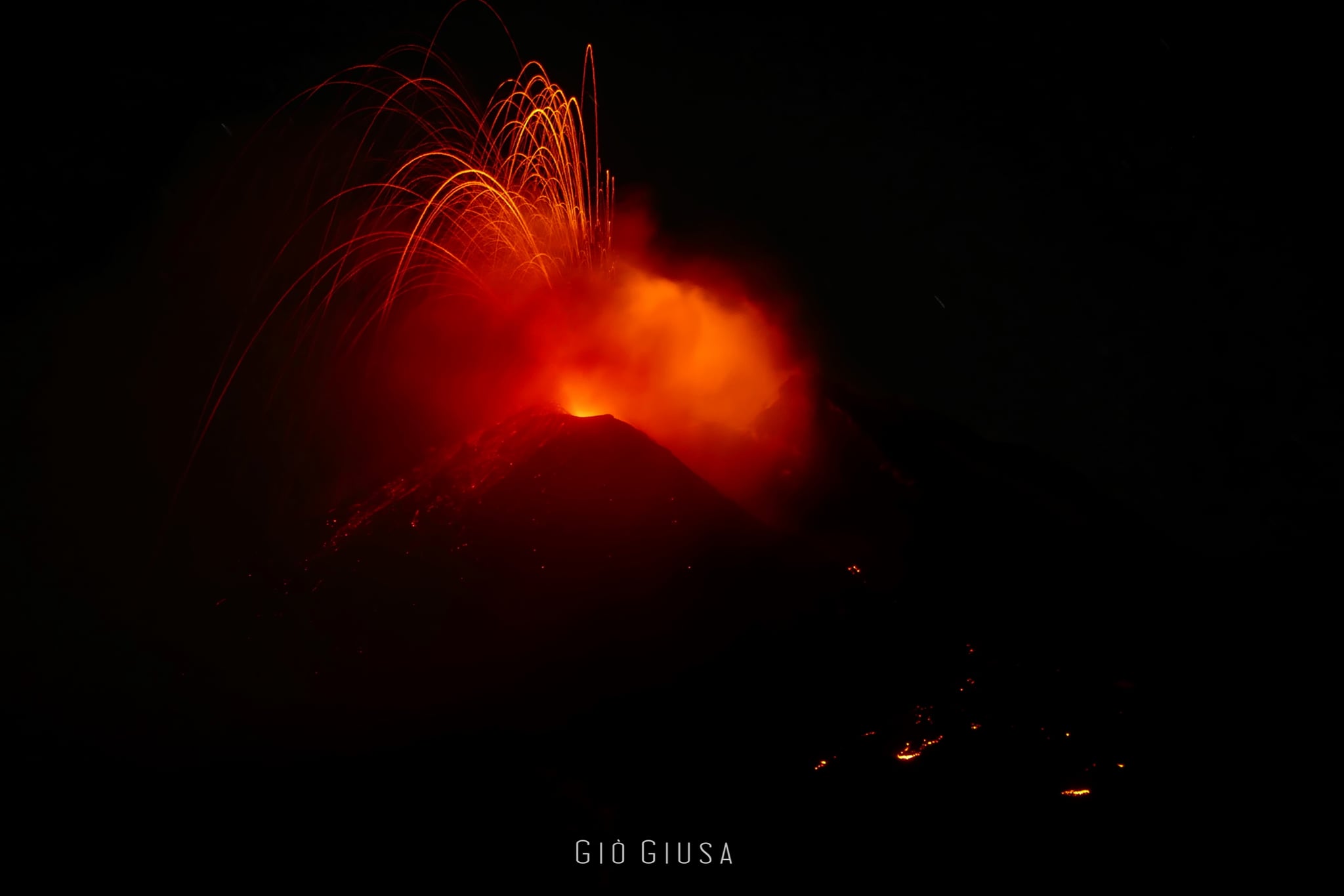
In the period considered, the activity of the summit craters of Etna, with the exception of the lava fountain of January 18, did not change compared to what was observed the previous week. This activity was characterized by a variable Strombolian activity, by a lava fountain episode, by the emission of overflow lava, and discontinuous ash emissions at the Southeast crater (SEC), by a strombolian activity mainly intra-crater at the Northeast crater (NEC), at the crater of Bocca Nuova (BN) and at the crater of Voragine (VOR) with sporadic emissions of ash which were immediately dispersed into the atmosphere.
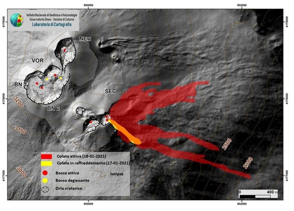
Map of the lava field from January 18 on a shaded model of the terrain of the summit area of Etna. BN: Bocca Nuova, VOR: Voragine; NEC: northeast crater; SEC: Southeast crater.
As of approximately 19:15 UTC, analysis of the CCTV images from the INGV-OE showed new lava overflow from the East Vent of the Southeast Crater (SEC) . The front branches off towards the Valle del Bove, east-south-east and reaches an altitude of about 2190 m above sea level, with a length of about 2 km . From 8:30 p.m. UTC, a new lava overflow developed on the north side of the Southeast Crater (SEC) which moved east-northeast to reach an altitude of ‘about 2500 m and a length of 1.3 km .
As of 19:15 UTC, there was also an increase in the intensity of Strombolian activity at the Southeast Crater (SEC).
Strombolian activity evolved into a lava fountain until reaching its maximum intensity around 8:30 p.m. UTC . The explosive activity generated by the lava fountain gradually decreased until it ended immediately after 9:00 p.m. UTC. On the morning of January 19, there was only weak Strombolian activity at the Southeast Crater (SEC) which formed a diluted volcanic cloud in the atmosphere as the lava fronts cooled.
The lava fountain produced a volcanic cloud that dispersed to the southeast, forming a deposit that affected the villages of Etna located on the southeast flank of the volcano.
The thin deposit was sampled by INGV-OE staff in Fleri and Acicastello.
Starting at approximately 12:40 UTC on January 20, a new lava overflow was observed on the north side of the Southeast Crater that was heading east northeast overlapping the lava flow of January 18 . At the same time, an increase in Strombolian activity was also observed .
The intensity of effusive activity decreased overnight, then regained strength at around 9.45 UTC and decreased again. By late afternoon, the fronts were cooling .
Finally, the activity of the Northeast crater (NEC), of Bocca Nuova (BN) and of Voragine (VOR) had a behavior comparable to that observed the previous week (Rep. N ° 03/2021), characterized by mainly intracrateral Strombolian emissions of varying intensity accompanied by sporadic and weak emissions of ash rapidly dispersed by high altitude winds.
Source : INGV.
Photos : Gio Giusa , INGV.
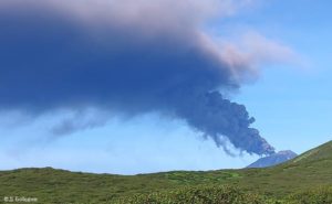
Italy , Stromboli :
Weekly bulletin, from January 18, 2021 to January 24, 2021. (issue date January 26, 2021)
SUMMARY OF THE STATE OF ACTIVITY.
In the light of surveillance data, it is highlighted:
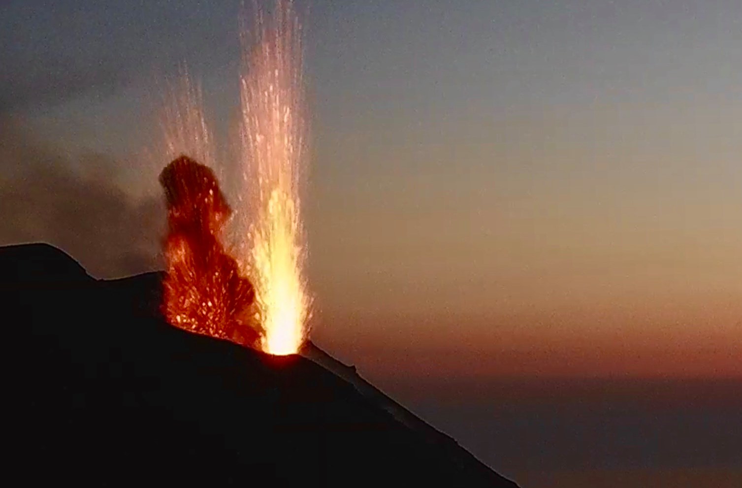
1) VOLCANOLOGICAL OBSERVATIONS: Ordinary explosive volcanic activity of Strombolian type with projection activity in the North zone and establishment of lava flows. The total frequency of events showed values oscillating between medium levels (13 events / h) and high levels (22 events / h). The intensity of the explosions was mainly medium-low in the North crater area and medium-high in the Center-South area.
2) SEISMOLOGY: The monitored seismological parameters do not show significant variations, except for the occurrence of the three lava overflows on 18-22-24 / 01 and the occurrence at 16:57 GMT on 24/01/2021 d ‘an explosive event of higher intensity than ordinary activity.
Finally, an increase in the amplitude of the tremor is reported from 01/22.

3) DEFORMATIONS: No significant change recorded by the tilt and GNSS networks.
4) GEOCHEMISTRY: SO2 flux: medium level
C / S Ratio – There is no updated data to date: the last available values referring to 06-12-2020 are at average levels (C / S = 12.1).
The isotope ratio of helium is at high values (R / Ra = 4.41 reported to the sampling of January 21, 2021).
5) SATELLITE OBSERVATIONS: The thermal activity in the summit area is at a medium-low level.
VOLCANOLOGICAL OBSERVATIONS
During the period under observation, the eruptive activity of Stromboli was characterized by the analysis of the images recorded by the surveillance cameras INGV-OE located at 190 m altitude, Punta Corvi and 400 m.
Four lava overflows occurred during this period, on January 18, 22 and 24, located in the area of the North crater beyond the edge of the N2 crater, in the upper area of the Sciara del fuoco. The two emission points are placed one at the limit between the area of the N1 crater and the N2 crater called P1 and the second on a hornito, observed since October, called P2 . In all the overflows, the intense throwing activity was a prelude to the lava flows.
The first overflow produced by P1 on January 18 between 10:11 UTC and 11:41 UTC showed a small flow composed of blocks of incandescent material which rolled for a few tens of meters in the upper part of the Sciara before stopping.
The second overflow was produced by P2 on January 18 between 3:00 p.m. UTC and 8:00 p.m. UTC. From 4:15 p.m. UTC, the flow of boulders was continuous even though the volume of material involved seemed modest. The products stopped in the central part of the Sciara.
The third overflow produced by P2 on January 22 between 11:22 UTC and 20:00 UTC shows a lava flow which, before breaking through, extends for a few hundred meters in the upper and central part of the Sciara. The volume of products from an estimate is much larger than the first two pours and the products reach the coast forming a small accumulation of a few tens of meters.
The fourth overflow produced by P2 on January 24 at 18:56 UTC stops at the end of the morning of January 25. The estimated product volumes are lower than the third overflow.
In the area of the North crater, the N1 crater, with two emission points, produced explosions of low intensity (less than 80 m high) to medium (less than 150 m high) emitting coarse materials (lapilli and bombs) mixed for purposes (ash). The N2 vent, at four emission points, mainly showed low to medium-high intensity explosive activity (sometimes the products were up to 250 m in height) emitting coarse materials. In addition, continuous projection activity was observed at the mouth of the N2 which for long periods was intense, reaching its peak on January 18, 22 and 23. The average frequency of explosions varied between 10 and 18 events / h.
In the Center-South zone, the explosions were produced by at least two vents, one of which produced only ash emissions and the other only large volumes of coarse incandescent material of medium and sometimes high intensity (the products reached 250 m in height).
The explosive activity showed hourly frequency values ranging from 1 to 7 events / h.
Source : INGV.
Photos : Stromboli ‘s pictures , webcam , INGV.
Chile , Cerro Hudson :
During the period, 146 earthquakes classified as volcano-tectonic (VT) were recorded, associated with the fracturing of rigid materials; the event with the highest energy had a local magnitude (ML) equal to 3.0 and was located 3.5 km northeast of the caldera center with a depth of 4.2 km.
– Similarly, 92 seismic events of the long period (LP) type have been classified, seismicity linked to the dynamics of fluids inside the volcanic building and / or produced by glacial activity; the largest earthquake presented an energy evaluated from the reduced displacement parameter (DR) equal to 26.1 cm2.
– In addition, 2 earthquakes classified as hybrid type (HB) were recorded, generally linked to a mechanism composed of a fracturing of a rigid material and a consequent disturbance due to the circulation of fluids inside volcanic conduits. The earthquake with the highest energy had a DR equal to 15.2 cm2.
– According to the data provided by 2 GNSS stations which make it possible to measure the surface deformation in the volcanic zones, movements of low magnitude are recorded, with rates lower than 0.3 cm / month.
– No anomalies were reported in the emissions of sulfur dioxide (SO2) in the atmosphere of the sector near the volcanic building.
– Similarly, no thermal alert was recorded in the area associated with the volcanic building.
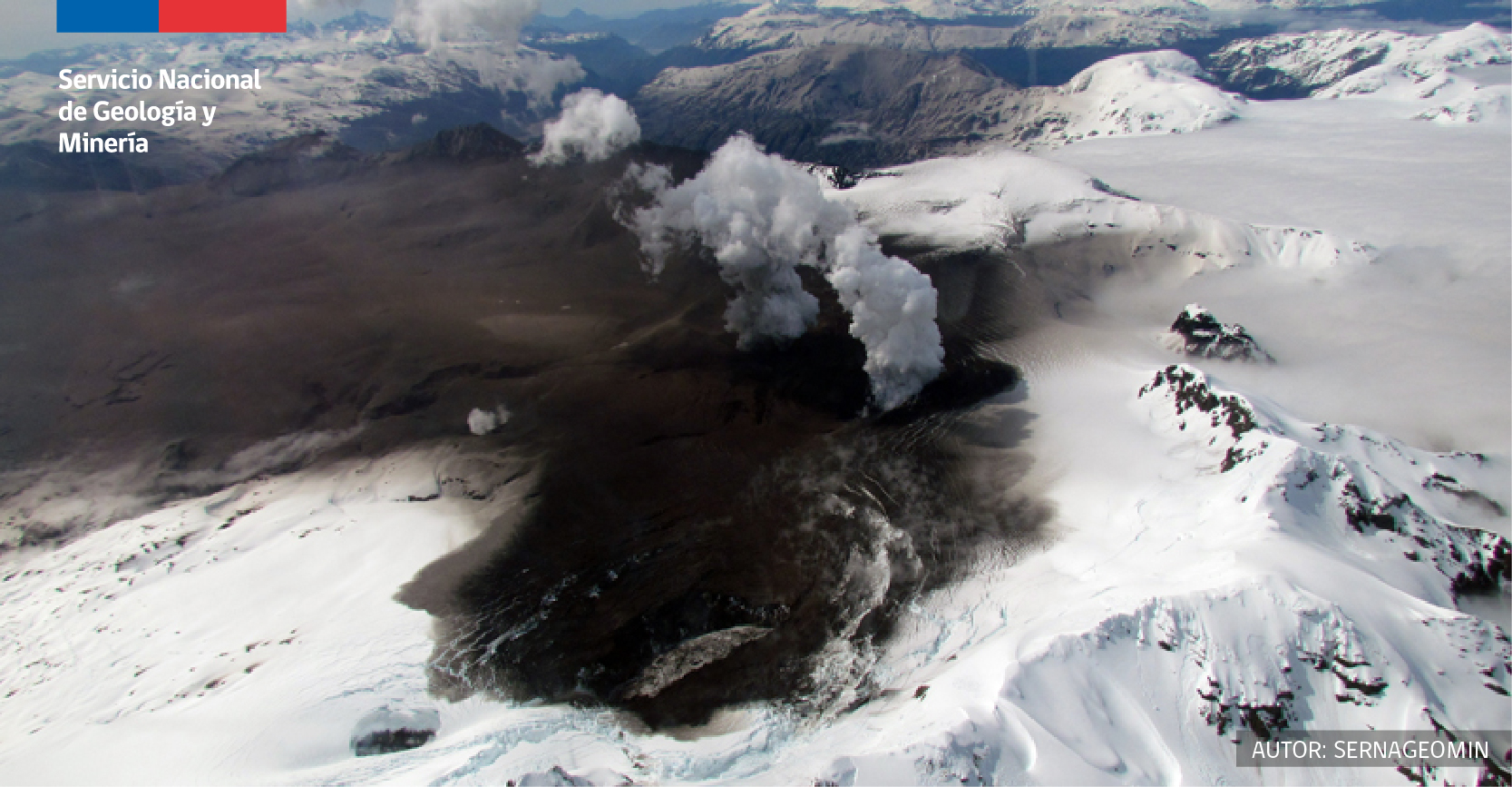
Volcanic activity continues to record recurrent VT and LP type seismicity, although with a slight decrease in its frequency and associated energy. Only the VT earthquake of magnitude (ML) equal to 3.0 stands out. In a smaller proportion, hybrid type earthquakes have been classified. Despite the above, the levels of seismicity are still considered abnormal and above the baseline. Although other volcanic parameters remain within levels considered normal, the temporary persistence of the described seismic activity suggests greater internal activity of the volcanic system. Based on the above, the technical alert is kept in yellow.
Source et photo : Sernageomin .
Indonesia , Merapi :
Observation of hot cloud avalanches from Mount Merapi on January 27, 2021 from 6 a.m. to 10 a.m. WIB.
More than ten avalanches have taken place on the Merapi.
At 9:19 a.m. WIB, the hot avalanche clouds were recorded on a seismogram with an amplitude of 30 mm and a duration of 113 seconds, column height not observed, foggy weather, estimated sliding distance of 1000 m in the southwest, upstream of Kali Krasak and Boyong.
At 9:31 WIB, hot avalanche clouds were recorded on the seismogram with an amplitude of 20 mm and a duration of 112 seconds, column height not observed, foggy weather, estimated sliding distance of 1000 m upstream of Kali Krasak and Boyong.
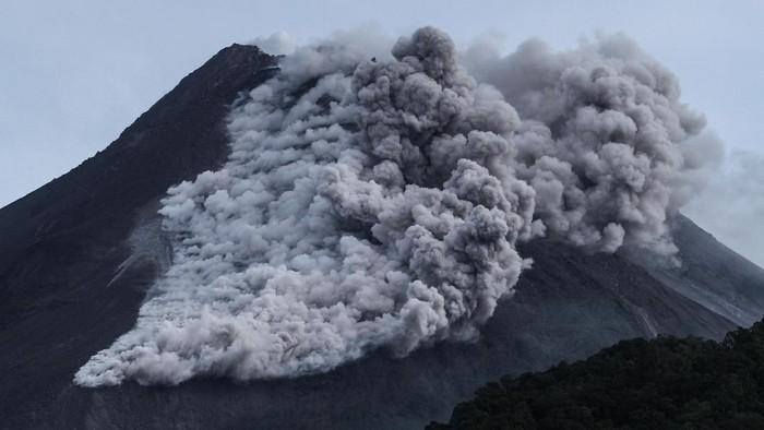
At 9:42 a.m. WIB, the hot avalanche clouds were recorded on the seismogram with an amplitude of 15 mm and a duration of 90 seconds, column height not observed, foggy weather, sliding distance estimated at 900 m to the south -west upstream of Kali Krasak and Boyong.
As a result of these hot clouds, it was reported that a light rain of ash had occurred in several villages in Tamansari district, Boyolali Regency and Boyolali town. The public is advised to anticipate disturbances due to volcanic ash.
Source : BPPTKG.
Photo : Detik.com