January 24 , 2019.
Colombia , Chiles / Cerro Negro :
Weekly activity bulletin Chiles and Cerro Negro volcanoes.
The activity level of volcanoes continues at the level: YELLOW LEVEL ■ (III): CHANGES IN THE BEHAVIOR OF THE VOLCANIC ACTIVITY.
Following the activities of the CHILE volcanoes and CERRO NEGRO, the COLOMBIAN GEOLOGICAL SERVICE (SGC) reports that:
For the period evaluated between January 15 and January 21, 2019, seismic activity in the Chiles – Cerro Negro volcanoes region recorded a significant decrease in the number of events compared to the previous week, from 2492 to 1106 earthquakes. earth, mainly cataloged as being of the volcano-tectonic type, associated with fracturing of cortical material in the volcanic building.
The hypocentres of these earthquakes were located southwest of the summit of the Chiles volcano to epicentral distances of 5 km and depths in their majority between 2 and 6 km compared to the summit (4700 m). The maximum local magnitude reached was M3.2 on the Richter scale.
Other geophysical and geochemical parameters of volcanic monitoring did not show significant variations.
Source : SGC .
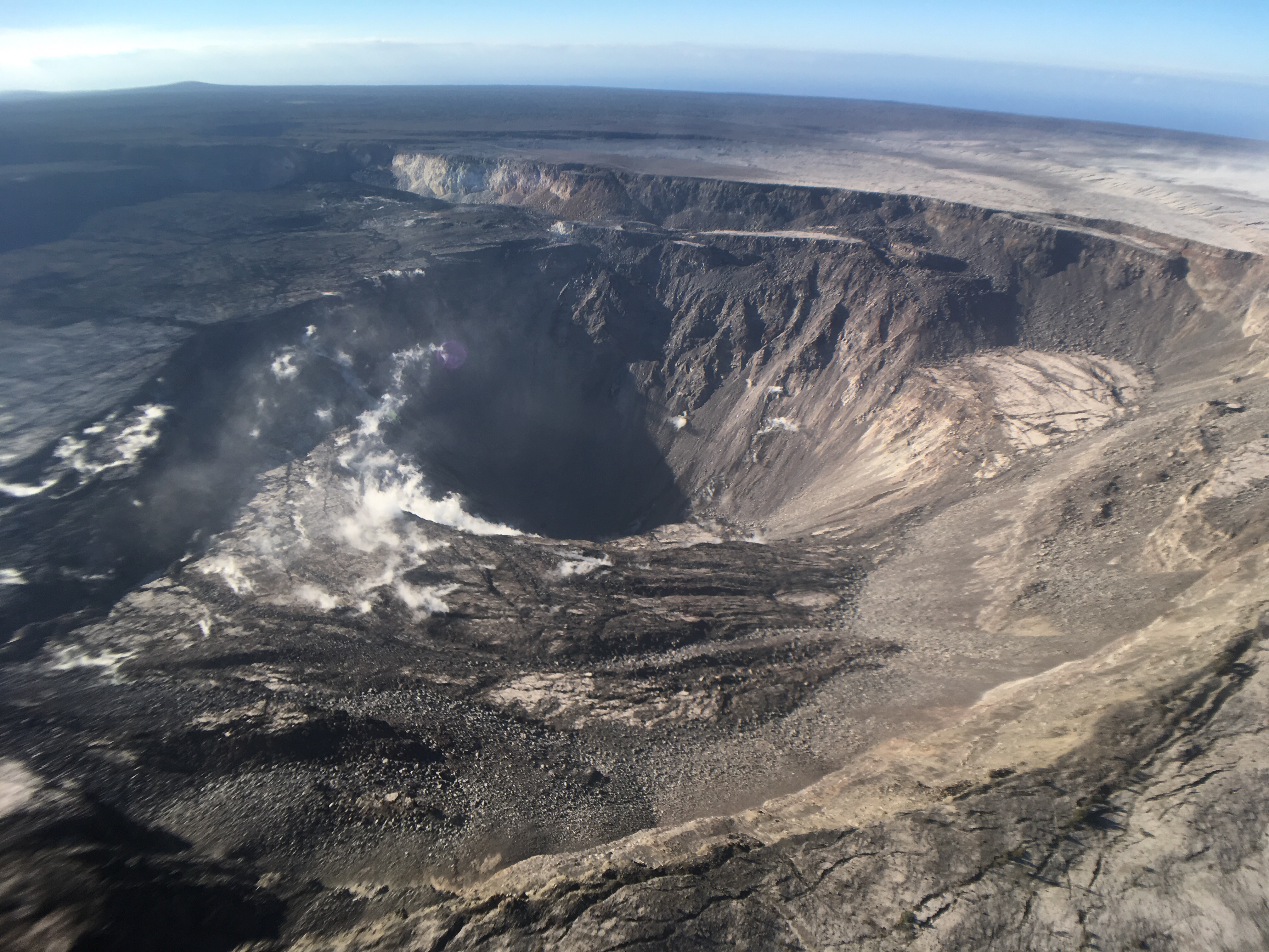
Hawaii , Kilauea :
19°25’16 » N 155°17’13 » W,
Summit Elevation 4091 ft (1247 m)
Current Volcano Alert Level: ADVISORY
Current Aviation Color Code: YELLOW
Activity Summary:
Kīlauea Volcano is not erupting. Rates of seismicity, deformation, and gas release have not changed significantly over the past week.
Observations:
Low rates of seismicity continue across the volcano, with events occurring primarily in the summit and south flank regions. Inflationary tilt in the middle East Rift Zone has slowed over the past week. Sulfur dioxide emission rates from the summit and Puʻu ʻŌʻō remain low.
Hazards remain in the LERZ eruption area and at the Kīlauea summit. Residents and visitors near recently active fissures and lava flows should heed Hawaii County Civil Defense and National Park warnings, and be prepared, if necessary, to self-evacuate in the unlikely event of renewed activity. Please note that Hawaii County maintains a closure of the entire lava flow field and vents and prohibits access unless authorized through Civil Defense.
The Hawaiian Volcano Observatory (HVO) continues to closely monitor Kīlauea’s seismicity, deformation, and gas emissions for any sign of reactivation. HVO maintains visual surveillance of the volcano with web cameras and occasional field visits. HVO will continue to issue a weekly update (every Tuesday) and additional messages as warranted by changing activity.
Source et photo : HVO.
Mexico , Popocatepetl :
January 23 at 11:00 am (January 23 at 17:00 GMT).
During the last 24 hours, thanks to the monitoring systems of the Popocatépetl volcano, 123 exhalations have been identified, resulting in the emission of water vapor, gas with a low ash content, as well as 61 minutes of low harmonic tremor. .
In addition, yesterday at 21:06, an explosion was recorded, generating an eruptive column 3.5 km high compared to the crater, as well as the emission of incandescent fragments falling on the slopes of the volcano over a distance of 2 km. Ash falls have been reported in Santa Isabel Cholula, Santa Ana Xalmimilulco, Domingo Arenas, San Martin Texmelucan, Tlalancaleca, San Salvador el Verde, San Andrés Calpan, San Nicolás de los Ranchos and Huejotzingo. in the state of Puebla.
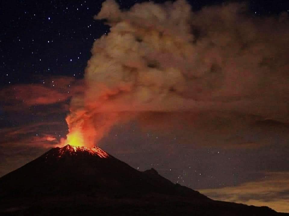
At the time of writing this report, the continuous emission of volcanic gases that disperse to the northeast is observed.
CENAPRED urges NOT to APPROACH the volcano and especially the crater, because of the risk of falling ballistic fragments, and in case of heavy rains, to move away from the bottom of the ravines because of the risk of landslides and mudslides.
The Popocatepetl warning light is located at Amarillo Phase 2.
Source : Cenapred.
Photo : Edith Tropper.
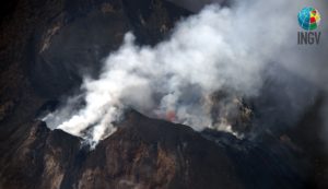
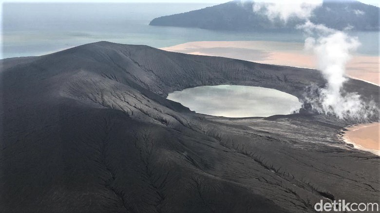
Indonesia , Anak Krakatau :
Level of activity level III (SIAGA) since December 27, 2018. The Anak Krakatau volcano (110 m altitude) has increased its volcanic activity since June 18, 2018.
Since yesterday and until this morning, the volcano was clearly visible then covered with fog. The smoke from the crater is not observed. The wind was weak in the east.
On the seismographs dated 23 January 2019, it was recorded:
8 earthquakes of emission.
9 deep volcanic earthquakes
Tremor continuous amplitude of 1 to 14 mm, and a dominant value of 4 mm.
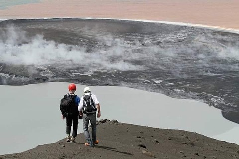
If the inhabitants of Sunda Strait, Banten and Lampung, are still afraid and are even traumatized by the activity of Gunung Anak Krakatau, after the landslide caused by the tsunami eruption of December 22, 2018, foreign tourists approached and laid on the lip of the crater. The photo was aired via the group of twitter users @rajo_ameh (Pascal Blonde) on January 17 and 18, 2019.
Recommendation:
People / tourists are not allowed to approach the crater within 5 km
VONA:
The latest VONA code sent, the color code ORANGE, published on January 8, 2019 at 18:11, and was associated with an eruption with a column of ash about 1110 m above sea level or about 1000 m above the summit. The ash column was moving eastward.
Source : PVMBG
Photo : P. Blonde via Berita Cilegon Online (BCO) , Arief/detikcom.