January 08 , 2021.
Italy / Sicily , Etna :
PRESS RELEASE ON ETNA’S ACTIVITY [UPDATE n. 114]
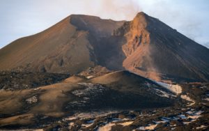
The National Institute of Geophysics and Volcanology, Osservatorio Etneo, reports that according to surveillance cameras and INGV personnel present in the summit area, a decrease in explosive activity at the Southeast Crater (SEC) is observed compared to the last update no. 113. Due to the cloud cover, which also affected the whole night the visibility was irregular. From the available images, we can observe that the explosive activity of variable nature continues at the Southeast crater and at the Voragine, even if it has strongly decreased. This activity still produces intermittent emissions of dilute ash, which are quickly dispersed in the summit area.
The volcanic tremor does not show significant variations compared to what was communicated previously and its amplitude fluctuates in the range of average values. The middle source is located in the area of the Southeast Crater between 2.8 and 3 km above sea level.
Infrasound activity over the past few hours did not show significant changes.
The distortion signals from the GPS and inclinometric networks do not presently show significant changes.
Further updates will be communicated shortly.
Source : INGV.
Photo : Boris Behncke .
Chile , Hudson :
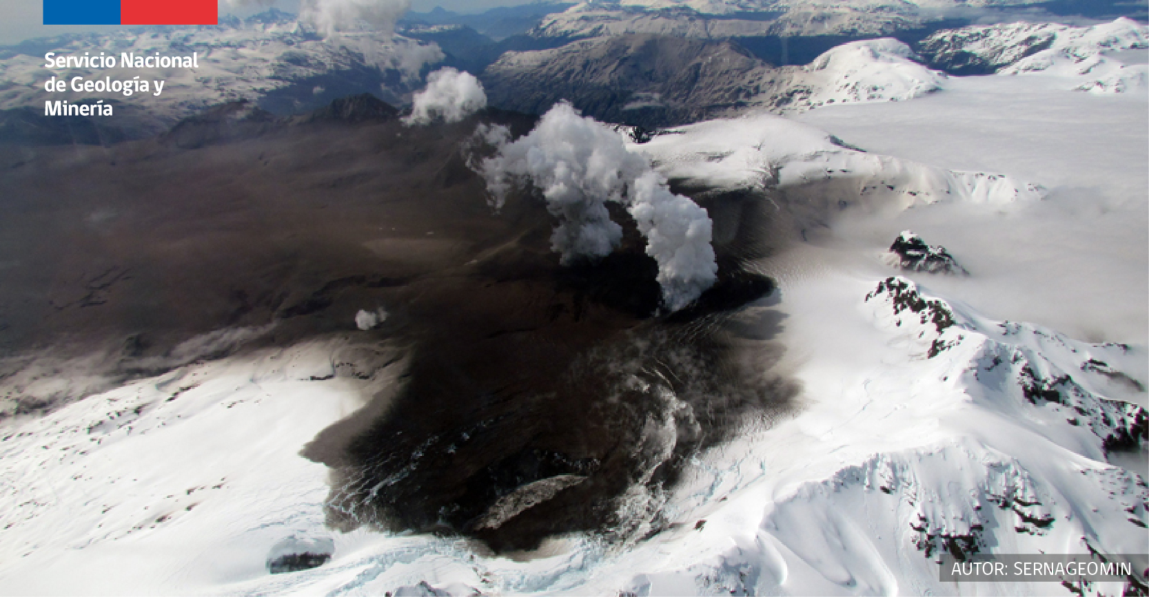
Special Report on Volcanic Activity (REAV), Aysen del General Carlos Ibanez del Campo region, Hudson volcano, January 06, 2021, 10:45 am local time (Continental Chile).
The National Service of Geology and Mines of Chile (Sernageomin) publishes the following PRELIMINARY information, obtained thanks to the monitoring equipment of the National Volcanic Monitoring Network (RNVV), processed and analyzed in the Volcanological Observatory of the Andes of the South (Ovdas):
On Wednesday, January 06, 2021, at 10:14 a.m. local time (1:14 p.m. UTC), the monitoring stations installed near the Hudson volcano recorded an earthquake linked to rock fracturing (Volcano-Tectonic type) located in the caldera of the volcano.
The characteristics of the earthquake after its analysis are as follows:
ORIGINAL TIME: 10:14 a.m. local time (13:14 UTC)
LATITUDE: 45.894 ° S
LONGITUDE: 72.985 ° W
DEPTH: 4.1 km
LOCAL MAGNITUDE: 3.0 (ML)
Observations:
The weather conditions did not allow the observation of the volcanic edifice
The volcanic technical alert remains at the Yellow level.
The ice-filled, 10-km-wide caldera of the remote Cerro Hudson volcano was not recognized until its first 20th-century eruption in 1971. It is the southernmost volcano in the Chilean Andes related to subduction of the Nazca plate beneath the South American plate. The massive volcano covers an area of 300 km2. The compound caldera is drained through a breach on its NW rim, which has been the source of mudflows down the Río de Los Huemeles. Two cinder cones occur N of the volcano and others occupy the SW and SE flanks. This volcano has been the source of several major Holocene explosive eruptions. An eruption about 6700 years ago was one of the largest known in the southern Andes during the Holocene; another eruption about 3600 years ago also produced more than 10 km3 of tephra. An eruption in 1991 was Chile’s second largest of the 20th century and formed a new 800-m-wide crater in the SW portion of the caldera.
Source : Sernageomin . GVP.
Photo : sernageomin.
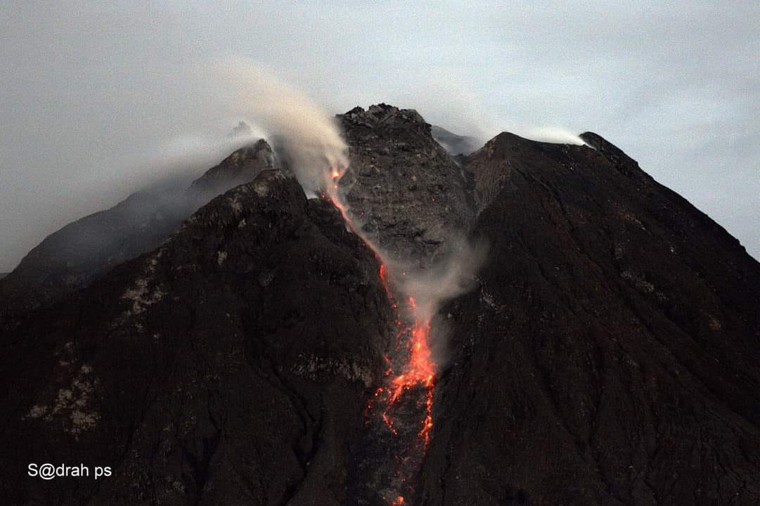
Indonésie , Sinabung :
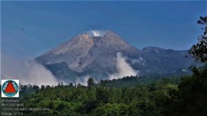
The activity level has been at level III (SIAGA) since May 20, 2019 at 10:00 a.m. Mount Sinabung (2460 m above sea level) has been erupting since 2013. The last eruption occurred on January 5, 2021 with a column height of 800 m from the summit of the peak.
The volcano was clearly visible until it was covered in fog. Eruptions occurred but the height of the eruption column was not observed. When there is no eruption, the crater is observed to emit white smoke with a moderate height, thick about 100-500 meters above the summit. The weather is sunny to rainy, with weak to moderate winds in the South, West and North-West.
According to the ismographs of January 7, 2021, it was recorded:
● 2 erupton earthquakes
● 42 avalanche earthquakes
● 7 emission earthquakes
● 6 low frequency earthquakes
● 19 hybrid / multi-phase earthquakes
● 5 distant tectonic earthquakes.
VOLCANO OBSERVATORY NOTICE FOR AVIATION – VONA.
Issued : January 07 , 2021
Volcano : Sinabung (261080)
Current Aviation Colour Code : ORANGE
Previous Aviation Colour Code : orange
Source : Sinabung Volcano Observatory
Notice Number : 2021SIN06
Volcano Location : N 03 deg 10 min 12 sec E 98 deg 23 min 31 sec
Area : North Sumatra, Indonesia
Summit Elevation : 7872 FT (2460 M)
Volcanic Activity Summary :
Eruption with volcanic ash cloud at 14h18 UTC (21h18 local).
Volcanic Cloud Height :
Ash-cloud is not visible
Other Volcanic Cloud Information :
Ash-cloud is not visible
Remarks :
Seismic activity is characterized by eruption volcanic event
Source : PVMBG, Magma Indonésie.
Photo : Sadrah Peranginangin , 04/01.
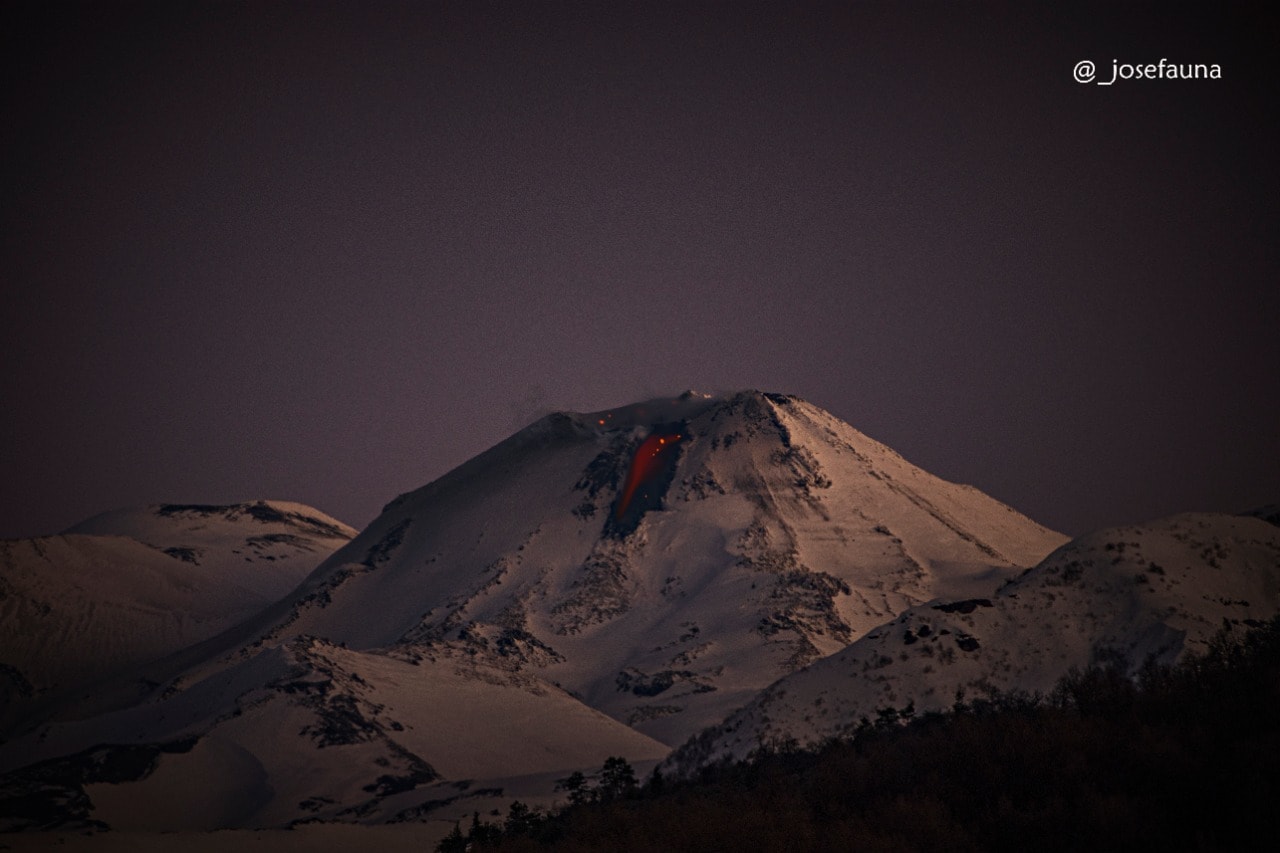
Chile , Nevados of Chillan :
Special Report on Volcanic Activity (REAV), Ñuble region, Nevados de Chillán volcanic complex, January 7, 2021, 06:15 local time (Continental Chile)
The National Service of Geology and Mines of Chile (Sernageomin) publishes the following PRELIMINARY information, obtained thanks to the monitoring equipment of the National Volcanic Monitoring Network (RNVV), processed and analyzed in the Volcanological Observatory of the Andes of the South (Ovdas):
On Thursday January 7, at 5:55 am local time (8:55 am UTC), the monitoring stations installed near the Nevados de Chillán Volcanic Complex recorded an earthquake linked to the fracturing of rocks (Volcano-Tectonics).
The characteristics of the earthquake after its analysis are as follows:
ORIGINAL TIME: 05:55 local time (08:55 UTC)
LATITUDE: 36.872 ° S
LONGITUDE: 71.372 ° W
DEPTH: 1.5 km
LOCAL MAGNITUDE: 3.5 (ML)
OBSERVATIONS:
After the occurrence of this event, no significant changes were recorded in the internal dynamics of the volcanic complex, as well as in the high intensity surface activity.
The volcanic technical alert remains at the Yellow level.
Source : Sernageomin .
Photo : Josefauna.
Guatemala , Pacaya :
SPECIAL VOLCANOLOGICAL BULLETIN
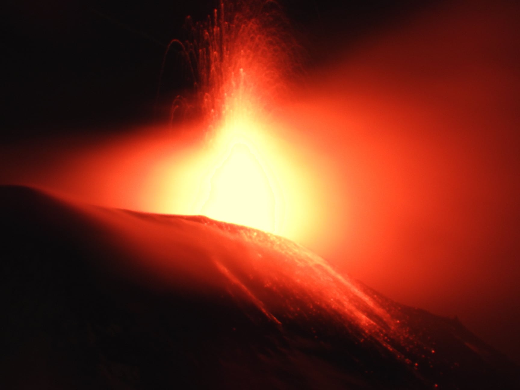
Explosions with ash emissions.
Surveillance and monitoring, as part of the Strombolian activity of the Pacaya, indicates that in the last hours, moderate to strong explosions are recorded accompanied by columns of ash that reach 300 to 500 meters above the crater. , which generate locomotive noises, rumblings and shock waves that vibrate the roofs and windows of villages near the volcano. The ejected ballistic projections reach a distance of 300 meters around the crater.
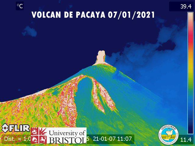
There is a likelihood that explosive activity will continue and ash columns will increase in the crater. All this is part of a phase of Strombolian activity of the Pacaya volcano, which may remain so for the next hours and days. On the north flank, at 07:40, two new lava flows of 200 and 50 meters long were generated, while on the southwest flank, the lava flow of 550 meters long continues to be observed.
There is a possibility of increased effusive and explosive activity.
INSIVUMEH maintains seismic and visual monitoring through the seismic stations of PCG and PCG5 and OVPAC, for any change or increase in activity that can be observed or recorded.
Source : Insivumeh .
Hawaii , Kilauea :
19°25’16 » N 155°17’13 » W,
Summit Elevation 4091 ft (1247 m)
Current Volcano Alert Level: WATCH
Current Aviation Color Code: ORANGE
Activity Summary:
Lava activity is confined to Halemaʻumaʻu with lava erupting from vents on the northwest side of the crater. Wednesday afternoon (Jan. 6), the lava lake was 194 m (636 ft) deep and perched 1-2 m (1-2 yds) above its edge. SO2 emission rates were still elevated.
Summit Observations:
Summit tiltmeters recorded weak deflationary tilt since Jan. 1; at 3pm yesterday (Jan. 6), rapid deflationary tilt started similar to the beginning of a possible deflation-inflation (DI) event.
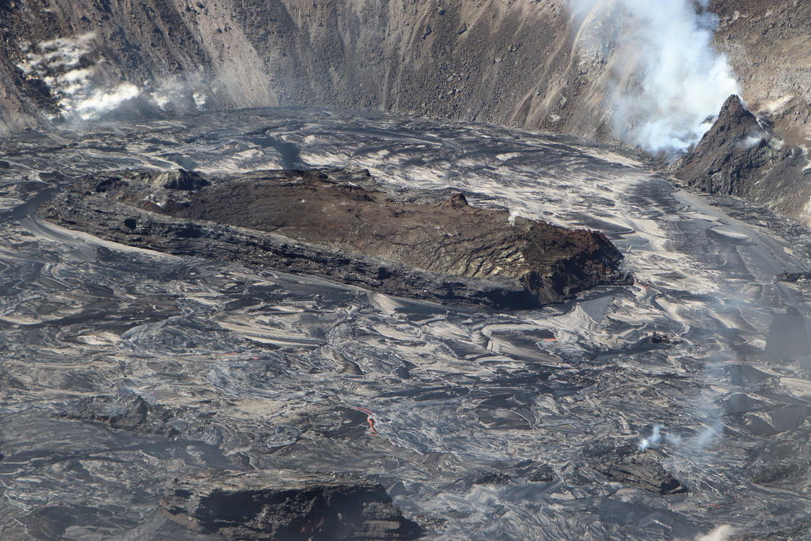
Aerial image of the active west vent area and the largest island in Halemaʻumaʻu’s growing lava lake. During the overflight of Kīlauea’s summit today (January 7, 2021) at approximately 10:30 a.m. HST, HVO geologists noted that the dome fountain, which had been persistent near the base of the west vent area, had subsided and was no longer present.
Halemaʻumaʻu lava lake Observations:
The west vents spattered from the top of a small cone plastered on the northwest wall of Halemaʻumaʻu crater. This morning, lava is presumed flowing through crusted channels to the lake and also feeding a small photogenic dome fountain in front of the west vents probably from a submerged portion of the vent.
As of Wednesday (Jan. 6), the lake was perched at least 1-2 m (1-2 yds) above its narrow edges; overflows onto the narrow edge slowly elevated a low wall around the lake similar to the wall around an above-ground swimming pool.
The main island of cooler, solidified lava floating in the lava lake continued rotating counter-clockwise, in front of the west lava source filling the lake, while the 11 smaller islands moved a bit but remained in the east end of the lake; at 10:30 pm last night, the island stalled in rotation and movement.
Source : HVO .
Photo : USGS photo by K. Mulliken.