October 27 , 2020 .
Philippines , Bulusan :
BULUSAN VOLCANO BULLETIN: 26 October 2020 05:00 P.M.
This serves as notice for the lowering of the alert status of Bulusan Volcano from Alert Level 1 (abnormal) to Alert Level 0 (normal).
Bulusan Volcano has returned to normalcy following a general decline in monitoring parameters. This is supported by the following observations:
Volcanic Earthquake Activity:
The frequency of volcanic earthquakes has declined to baseline levels (0-2 earthquakes/day) since late September 2020. This indicates that rock fracturing within the volcanic system associated with hydrothermal activity has diminished.
Ground Deformation:
Ground deformation data from continuous GPS measurements indicate slight deflation on the edifice since July 2020, while the long-term trend since May 2019 denotes that the edifice is still deflated. The overall ground deformation data indicate that there is no pressurization from subsurface magma.
Gas Emission:
Sulfur dioxide emission or SO2 flux from Bulusan based on gas spectrometry remains below detection levels since 2018. The relatively low levels of SO2 flux indicate depletion of gas supplied from the active shallow hydrothermal system, although an increase of ambient carbon dioxide or CO2 concentration in monitored springs relative to August 2020 suggests that degassing from the deeper magmatic source continues.
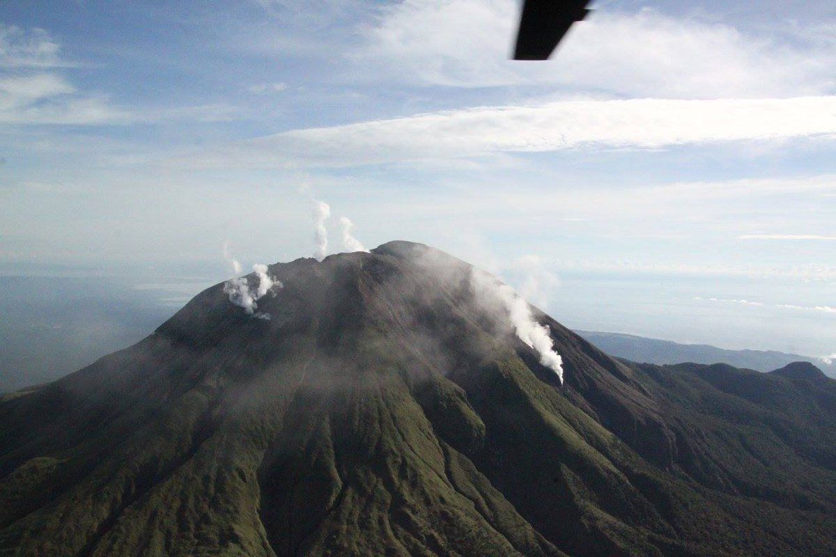
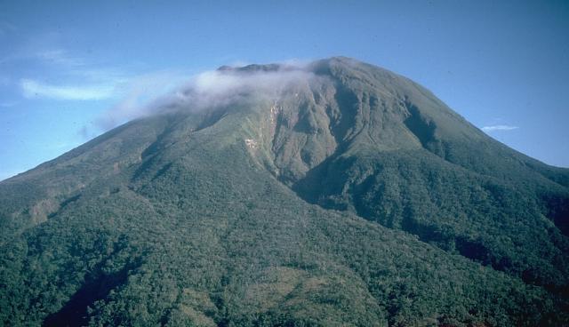
Visual Observation of the Summit:
Surface activity from the active vents has been characterized by very weak to weak emission of steam-laden plumes consistent with diminished hydrothermal activity.
In view of the above, PHIVOLCS-DOST is now lowering the alert status of Bulusan from Alert Level 1 to Alert Level 0. This means observational parameters have returned to baseline or background levels and no magmatic eruption is foreseen in the immediate future. However, in the event of a renewed increase in any one or combination of the above monitoring parameters, the alert status may step up once again to Alert Level 1.
The local government units and the public, however, are reminded that entry into the 4-kilometer radius Permanent Danger Zone (PDZ), particularly near the vents on the south-southeastern slopes, should be avoided due to the possibility of sudden and hazardous steam-driven or phreatic eruption, rockfall and landslide. Civil aviation authorities must also advise pilots to avoid flying close to the volcano’s summit as ash from any sudden phreatic eruption can be hazardous to aircraft. Furthermore, people living within valleys and along river/stream channels should be vigilant against sediment-laden stream flows and lahars in the event of heavy and prolonged rainfall. DOST-PHIVOLCS is closely monitoring Bulusan Volcano’s condition and any new development will be relayed to all concerned.
This will be the last bulletin for Bulusan Volcano until new developments in monitoring parameters occur.
Source : Phivolcs .
Photos : Phivolcs , Wikipedia .
Peru , Sabancaya :
Analysis period: October 19 to 25, 2020, Arequipa, October 26, 2020.
Alert level: ORANGE
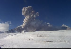
The Geophysical Institute of Peru (IGP) reports that the eruptive activity of the Sabancaya volcano remains at moderate levels, that is, with the continuous recording of explosions with columns of ash and gas up to 2.5 km altitude above the summit of the volcano and their subsequent dispersion. Therefore, for the following days, no significant change is expected in the eruptive activity.
The IGP recorded and analyzed the occurrence of 2,203 earthquakes of volcanic origin, associated with the circulation of magmatic fluids inside the Sabancaya volcano. An average of 37 explosions were recorded daily of low to medium intensity. During this period, Volcano-Tectonic (VT) earthquakes were located mainly in the North-West and East of Sabancaya and presented magnitudes between M2.3 and M3.6. The most representative earthquake (M3.6) was recorded on October 25 at 12:09 am, 24 km northwest of Sabancaya and 13 km deep.
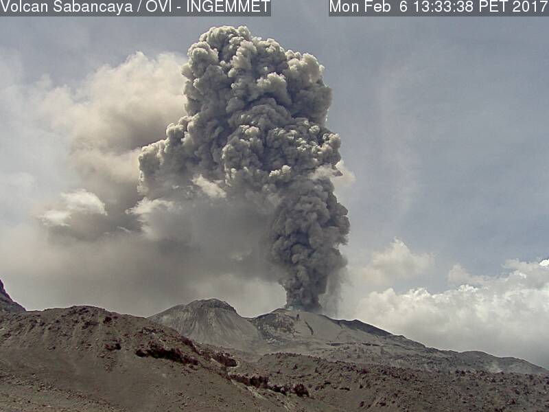
The monitoring of the deformation of the volcanic structure using GNSS techniques (processed with fast orbits) does not present any significant anomalies. However, since October 11, 2020, a process of deflation (collapse) has been observed in the south-eastern sector of Sabancaya. Visual surveillance identified columns of gas and ash up to 2.5 km altitude above the summit of the volcano, which were scattered to the South-West, West, North-West and south-east of Sabancaya. Weak ash fall was reported in the districts of Huanca on October 19 and 22, and Lluta on October 19 and 24. Satellite monitoring has identified the presence of 9 thermal anomalies with values between 2 MW and 28 MW, associated with the presence of a lava body on the surface of the volcano crater.
RECOMMENDATIONS
• Keep the volcanic alert level in orange.
• Do not approach within a radius of less than 12 km from the crater.
Source : IGP.
Photo : Ingemmet ( archive 2017) .
Montserrat , Soufrière Hills :
On the evening of 19 October 2020, a cloud-free lava dome was photographed from both MVO and Jack Boy Hill.
A series of digital photographs and thermal images were acquired from both locations to capture the fumaroles and hot spots on the lava dome.
MVO volcanologist Dr Adam Stinton explains: « The digital photographs captured some incandescence (or glow) from three prominent fumaroles in the cliff that forms the rear wall of the 2010 collapse scar.
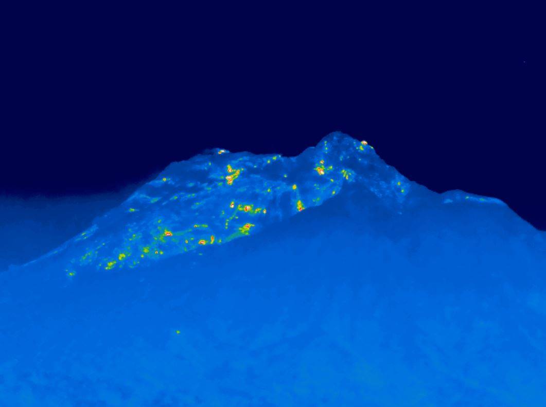
The composites show thermal images overlaid on digital photographs of the lava dome from MVO and Jack Boy Hill. All images were taken between 9:30 and 11:00 PM.
The incandescence recorded in the digital photographs was not visible to the naked eye, even with the use of binoculars. Both digital photographs had a 30 second exposure length.
Comparing these images to previous ones indicates that there are no changes to the number and distribution of incandescent features and hot spots.”
MVO Weekly Report for the Period 16 October to 23 October 2020
Activity at the Soufrière Hills Volcano remains low.
The seismic network recorded nine volcano tectonic earthquakes this week.
There are no SO2 flux measurements to report during this reporting period.
Due to the large size of the lava dome, pyroclastic flows can occur at any time without warning on any side of the volcano, including Gages from where they can travel rapidly into Plymouth. Tracks across the Belham Valley can be destroyed or heavily modified by flash flooding or lahars, and caution should be exercised crossing the valley during and after rainfall.
Source : MVO.
Guatemala , Pacaya :
SPECIAL VOLCANOLOGICAL BULLETIN
VOLCANIC ACTIVITY UPDATE
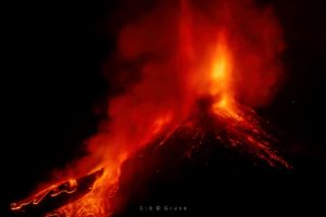
The volcanic activity of the Pacaya volcano recorded last week was mainly effusive with periods of moderate to strong Strombolian explosiveness that rejects materials up to 250 meters above the crater. Some explosions generate rumblings and ballistic projections within a radius of about 50 meters, constant incandescence and degassing also visible from various points in Guatemala City.
This degassing generates a white / blue plume due to its water and sulfur dioxide composition. Ash falls were also reported in the villages of Los Pocitos and Los Llanos. Explosive activity keeps the cycle of building and destroying the intracrater cone active. The activity was also accompanied by sounds similar to those of a train locomotive and an airplane turbine, due to the pressure of magmatic gases.
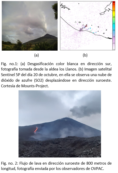
The currently active lava flows, reported by INSIVUMEH observers, are moving in a northeast direction and another in a southwest direction for 350 meters and 800 meters, respectively.
The seismic activity recorded by the PCG and PCG5 stations is the same as in recent months when there were periods of greater activity and decrease in it, as well as tremors generated by the movement of lava flows, l rise of magma and the pressure of magmatic gases.
The explosive activity generates low to moderate rumblings that vibrate the windows and roofs of houses in the villages of San Francisco de Sales, El Patrocinio, El Rodeo and others, located within a radius of 4 kilometers around the volcano.
INSIVUMEH provides visual and instrumental surveillance, using a web camera, seismic stations (PCG and PCG5) and OVPAC observers.
Source : Insivumeh .
Photo : Deybin fotografía via Nadin Hubrich.