October 22 , 2020.
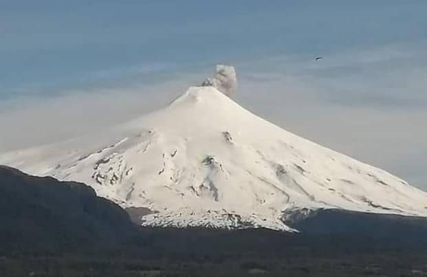
Chile / Argentina , Villarica :
Special Volcanic Activity Report (REAV), La Auracania and Los Rios region, Villarica volcano, October 20, 2020 at 6:00 p.m. local time (mainland Chile).
The National Service of Geology and Mines of Chile (Sernageomin) discloses the following PRELIMINARY information, obtained through the monitoring equipment of the National Volcanic Monitoring Network (RNVV), processed and analyzed at the Volcanological Observatory of the South Andes (OVDAS ):
On Tuesday, October 20, 2020 at 5:22 p.m. local time (8:22 p.m. UTC), the monitoring stations installed near the Villarica volcano recorded a long-period (LP) earthquake, associated with a moderate explosion at the level of the active crater, with reduced displacement values (DR) equal to 7.4 cm2 (value considered low). This process was accompanied by an infrasound signal of less than 2 Pascals (value reduced to 1 km as a reference).
The characteristics of the associated surface activity are as follows:
MAXIMUM HEIGHT OF THE COLUMN: 240 meters above the point of emission.
DIRECTION OF DISPERSAL: South.
OBSERVATIONS:
Through fixed cameras, a gray emission column was observed, with the presence of particulate materials dispersing in a southerly direction relative to the crater.
At the time of this report, no significant changes in seismicity have been observed which continues at a low level, as previously recorded.
The volcanic technical alert is maintained at the YELLOW level.
Source : Sernageomin .
Photo : J. Eduardo Mortis.
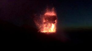
Kamchatka , Bezymianny :
VOLCANO OBSERVATORY NOTICE FOR AVIATION (VONA).
Issued: October 22 , 2020
Volcano: Bezymianny (CAVW #300250)
Current aviation colour code: ORANGE
Previous aviation colour code: red
Source: KVERT
Notice Number: 2020-193
Volcano Location: N 55 deg 58 min E 160 deg 35 min
Area: Kamchatka, Russia
Summit Elevation: 9452.96 ft (2882 m)
Volcanic Activity Summary:
21/10 : According to data by Tokyo VAAC, the explosive eruption of Bezymianny volcano began at 20h22 UTC on 21 October. A large ash cloud move to the northern directions of the volcano. The ash cloud have 44 km length to the northwest and 36 km length to the northeast. The eruption is continues.
The explosive eruption of Bezymianny volcano finished. The large ash cloud continues to be in the area of Klyuchevskoy group of volcanoes, but its height has decreased to 5-5.5 km a.s.l. The cloud has divided on the northern part (105×57 km in size) and the southern (36×67 km in size).
Activity of Bezymianny volcano continues. Ongoing its activity could affect low-flying aircraft.
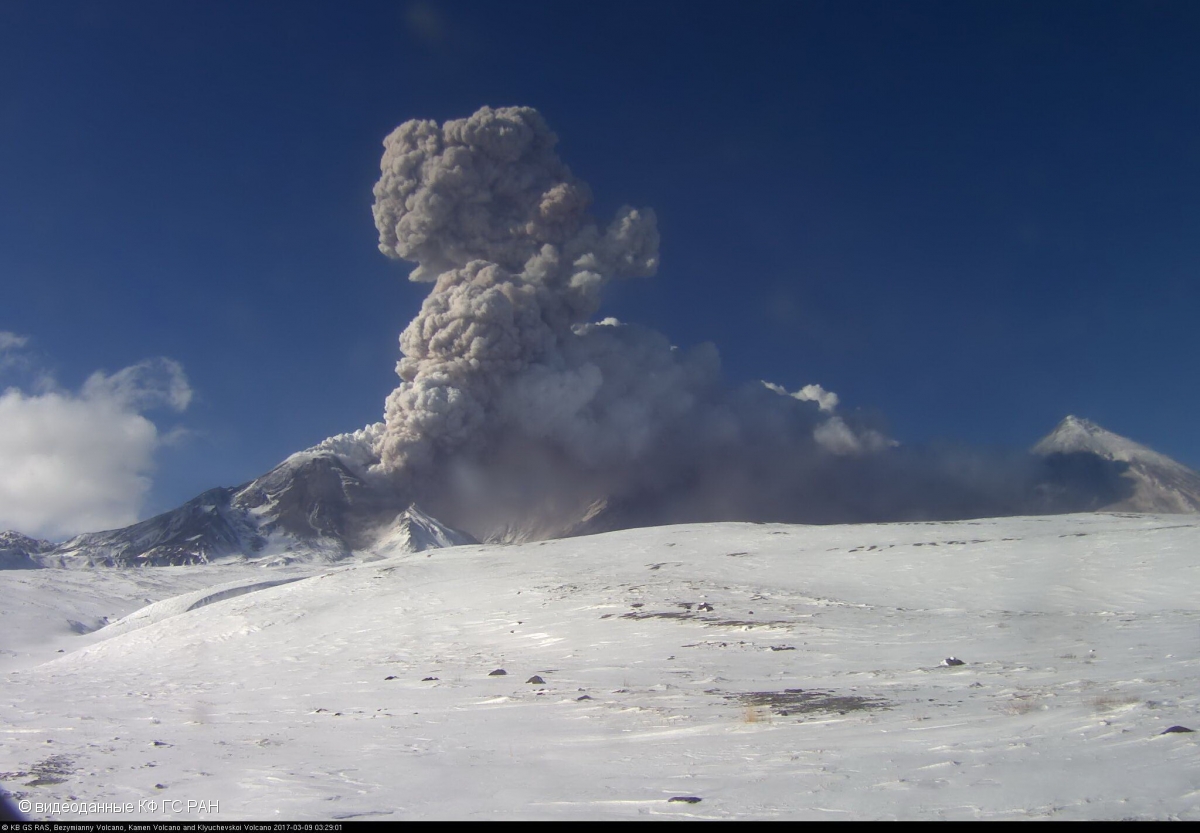
Explosive eruption of Bezymianny volcano on 09 March 2017
Volcanic cloud height: 16400-18040 ft (5000-5500 m) AMSL Time and method of ash plume/cloud height determination: 20201022/0230Z – Himawari-8
Other volcanic cloud information:
Distance of ash plume/cloud of the volcano: 73 mi (118 km)
Direction of drift of ash plume/cloud of the volcano: N / azimuth 352 deg
Time and method of ash plume/cloud determination: 20201022/0230Z – Himawari-8
Start time of explosion and how determined: 20201021/2022Z – Video data
Source : Kvert .
Photo : videodata KB GS RAS.
Video : You tube
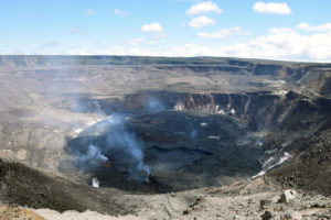
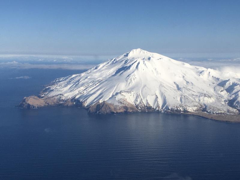
Alaska , Great Sitkin :
AVO/USGS Volcanic Activity Notice
Current Volcano Alert Level: NORMAL
Previous Volcano Alert Level: ADVISORY
Current Aviation Color Code: GREEN
Previous Aviation Color Code: YELLOW
Issued: Wednesday, October 21, 2020, 3:21 PM AKDT
Source: Alaska Volcano Observatory
Location: N 52 deg 4 min W 176 deg 6 min
Elevation: 5709 ft (1740 m)
Area: Aleutians
Volcanic Activity Summary:
Seismicity at Great Sitkin has been steadily decreasing for the past several months and is now at background levels. No eruptive activity or unusual surface temperatures have been observed in clear satellite imagery. The Alaska Volcano Observatory is returning the Aviation Color Code and Alert Level to GREEN/NORMAL to reflect these background conditions. AVO will continue to monitor the volcano using seismic, infrasound, web camera, and satellite observations.
Great Sitkin is monitored with a local real-time seismic network, which will typically allow AVO to detect changes in unrest that may lead to an explosive eruption. Rapid detection of an ash-producing eruption would be accomplished using a combination of seismic, infrasound, lightning, and satellite data.
Recent Observations:
[Volcanic cloud height] n/a
[Other volcanic cloud information] n/a
Remarks:
Great Sitkin Volcano is a basaltic andesite volcano that occupies most of the northern half of Great Sitkin Island, a member of the Andreanof Islands group in the central Aleutian Islands. It is located 43 km (26 miles) east of the community of Adak. The volcano is a composite structure consisting of an older dissected volcano and a younger parasitic cone with a 3-km-diameter summit crater. A steep-sided lava dome, emplaced during an eruption in 1974, occupies the center of the crater. Great Sitkin erupted at least three times in the 20th century, most recently in 1974. That eruption produced at least one ash cloud that likely exceeded an altitude of 25,000 ft above sea level. A poorly documented eruption occurred in 1945, also producing a lava dome that was partially destroyed in the 1974 eruption. Within the past 280 years a large explosive eruption produced pyroclastic flows that partially filled the Glacier Creek valley on the southwest flank.
Source : AVO.
Photo : Fischer, Ed.
Japan , Sakurajima :
31.593°N, 130.657°E
Elevation 1117 m
JMA reported that during 14-20 October incandescence from Minamidake Crater (at Aira Caldera’s Sakurajima volcano) was visible nightly. A small eruption was recorded on 13 October. During an overflight that same day scientists observed lava at the bottom of the crater. The Alert Level remained at 3 (on a 5-level scale).
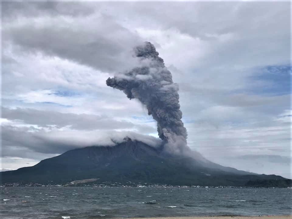
The Aira caldera in the northern half of Kagoshima Bay contains the post-caldera Sakurajima volcano, one of Japan’s most active. Eruption of the voluminous Ito pyroclastic flow accompanied formation of the 17 x 23 km caldera about 22,000 years ago. The smaller Wakamiko caldera was formed during the early Holocene in the NE corner of the Aira caldera, along with several post-caldera cones. The construction of Sakurajima began about 13,000 years ago on the southern rim of Aira caldera and built an island that was finally joined to the Osumi Peninsula during the major explosive and effusive eruption of 1914. Activity at the Kitadake summit cone ended about 4850 years ago, after which eruptions took place at Minamidake. Frequent historical eruptions, recorded since the 8th century, have deposited ash on Kagoshima, one of Kyushu’s largest cities, located across Kagoshima Bay only 8 km from the summit. The largest historical eruption took place during 1471-76.
Source:Japan Meteorological Agency (JMA) , GVP.
Photo : Koki Arima ( archives ).
Japan , Suwanosejima :
29.638°N, 129.714°E
Elevation 796 m
JMA reported nighttime incandescence and intermittent eruptive activity at Suwanosejima’s Ontake Crater during 9-16 October. Four explosions were recorded during 12-14 October; an explosion at 0100 on 13 October ejected bombs 400 m from the crater and an explosion at 03h13 on 14 October produced an ash plume that rose 1.2 km above the crater rim. Ashfall was periodically reported in Toshima village, 4 km SSW. The Alert Level remained at 2 (on a 5-level scale).
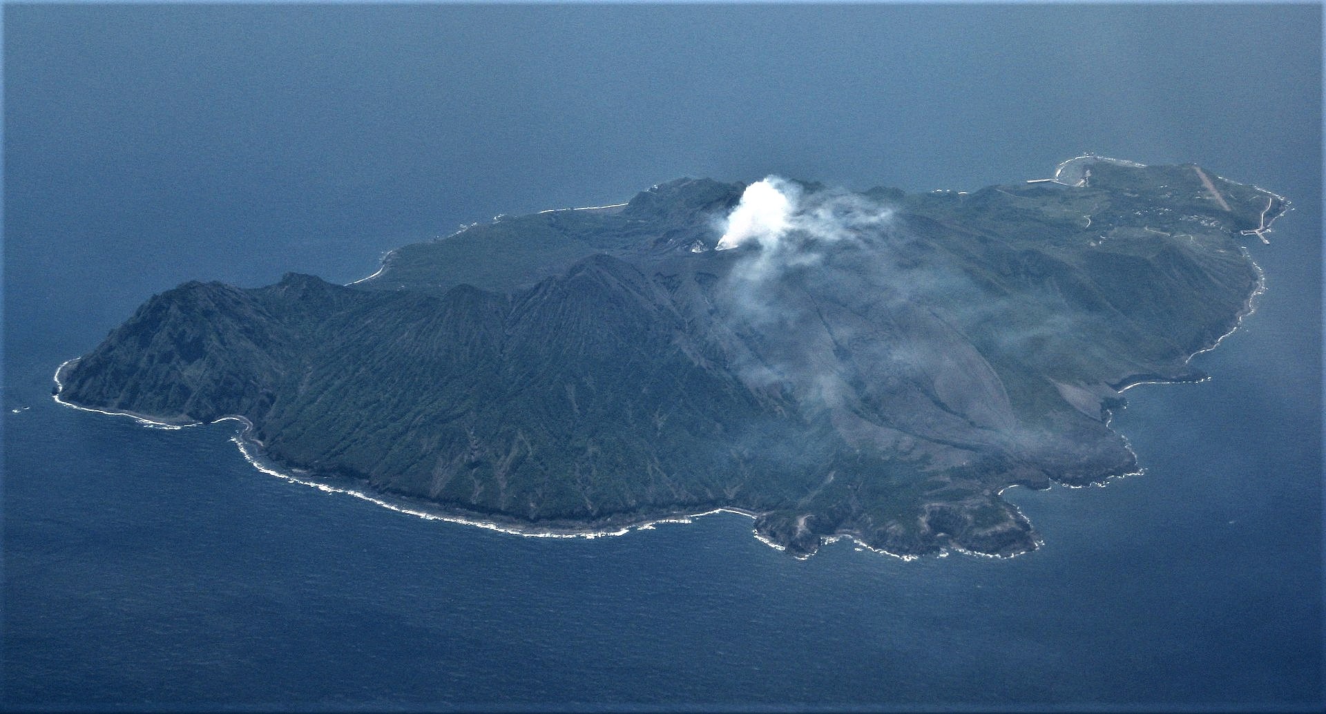
The 8-km-long, spindle-shaped island of Suwanosejima in the northern Ryukyu Islands consists of an andesitic stratovolcano with two historically active summit craters. The summit is truncated by a large breached crater extending to the sea on the east flank that was formed by edifice collapse. Suwanosejima, one of Japan’s most frequently active volcanoes, was in a state of intermittent strombolian activity from Otake, the NE summit crater, that began in 1949 and lasted until 1996, after which periods of inactivity lengthened. The largest historical eruption took place in 1813-14, when thick scoria deposits blanketed residential areas, and the SW crater produced two lava flows that reached the western coast. At the end of the eruption the summit of Otake collapsed forming a large debris avalanche and creating the horseshoe-shaped Sakuchi caldera, which extends to the eastern coast. The island remained uninhabited for about 70 years after the 1813-1814 eruption. Lava flows reached the eastern coast of the island in 1884. Only about 50 people live on the island.
Source:Japan Meteorological Agency (JMA) , GVP .
Photo : Ray Go.