March 18 , 2020 .
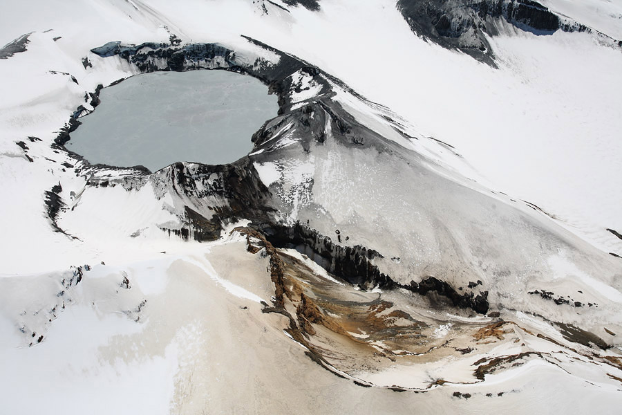
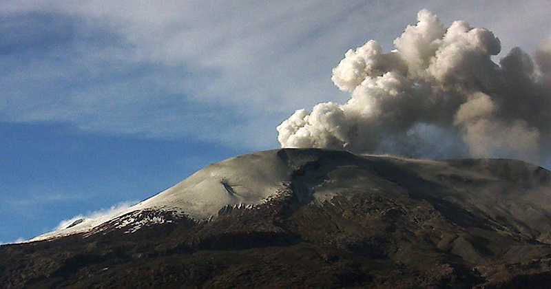
New Zealand , Ruapehu :
Volcanic Alert BulletinRUA – 2020/04 , Wed Mar 18 2020 10:30 AM.
Volcanic Alert Level remains at 1
Aviation Colour Code remains at Green
Crater Lake (Te Wai ā-moe) has been heating in response to an input of hot gases and hydrothermal fluids following volcanic earthquakes beneath Mt Ruapehu in February. The lake temperature is now 40°C. GNS Science volcanologists have collected further data to understand current activity.
Volcanologists have collected water samples from Crater Lake this week to understand current activity at the volcano. These samples are being analysed this week, with chemistry results expected by next week.

Crater Lake (Te Wai ā-moe) has heated from 24ºC to reach about 40 ºC following these volcanic earthquakes. We reported in our last bulletin that upwelling of grey sediment and sulphur slicks on the lake surface were observed. Now the lake is well mixed and has changed to a uniform grey colour. The continued flow of gases and hydrothermal fluids through the lake show that the volcano’s vent underlying Crater Lake is open.
The lake is overflowing at the outlet channel, with a notable decrease in the flow rate between our last two visits.
Volcanic tremor increased in response to the volcanic earthquakes, peaking in early March, then declined slowly until today.
Modelling of the energy input into the lake shows that the heat input increased from around 200 MW to around 600 MW but has now declined as the temperature rise has slowed. Heating cycles such as this are very common at Ruapehu.
The amounts of carbon dioxide (CO2) and sulphur gases (SO2 and H2S) in the atmosphere above the volcano measured on 28 February was greater than when measured on 7 February. However, the recent values are not unusual and are within the ranges measured over the past year.
The Volcanic Alert Level remains at Level 1. The Volcanic Alert Level reflects the current level of volcanic activity and is not a forecast of future activity. Mt Ruapehu is an active volcano and has the potential to erupt with little or no warning when in a state of volcanic unrest. There is no change in the Aviation Colour Code from Green.
GNS Science and the National Geohazards Monitoring Centre continues to closely monitor Mt Ruapehu for further signs of activity. GeoNet monitors Mt Ruapehu via a network of seismic, acoustic and thermal sensors, GPS receivers, visits to the lake area and gas flights.
Source : Geonet / Art Jolly , Duty Volcanologist.
Photo : Brad Scott / GNS Science , Geonet.
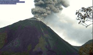
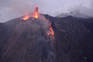
Italy / Sicily , Etna :
Weekly bulletin from 09/03/2020 to 15/03/2020 (date of issue 17/03/2020)
SUMMARY OF THE ACTIVITY STATUS.
In light of the monitoring data, it is highlighted:
1) VOLCANOLOGICAL OBSERVATIONS: Strombolian and effusive intra-crater activity of the Voragine crater. Emissions of discontinuous ash from the Northeast Crater and the New Southeast Crater.
2) SEISMOLOGY: Modest seismic fracturing activity; amplitude of the volcanic tremor at the high level.
3) INFRASONS: Mainly moderate activity, with a more frequent frequency of occurrence of events during the weekend.
4) DEFORMATIONS: The Etna soil deformation monitoring networks have not shown any significant variation to report during the last week.
5) GEOCHEMISTRY: the flow of SO2 is at a medium-low level. Soil CO2 flow values are low to medium. The partial pressure of dissolved CO2 does not show significant variations. The isotopic ratio of helium is fixed at medium-high values (last update of 2/14/2020). No update on the CO2 / SO2 ratio is available.

VOLCANOLOGICAL OBSERVATIONS
During the week, monitoring of volcanic activity in the summit craters of Mount Etna (Fig. 3.1) was carried out by analyzing images from the network of surveillance cameras from the INGV Catania section, Etneo Observatory (INGV- OE) and through an inspection of INGV-OE staff on 14, during which videos and photos of the eruptive activity were acquired and some samples of the products of the eruption were taken.
The inspection made it possible to observe an abundant degassing activity of the upper craters, of the North-East crater (NEC) which the day before (March 13) had produced low emissions of ash which immediately dispersed in the atmosphere, and the New Southeast Crater. The latter was also characterized by sporadic ash emissions accompanied by audible roars even at long distances.
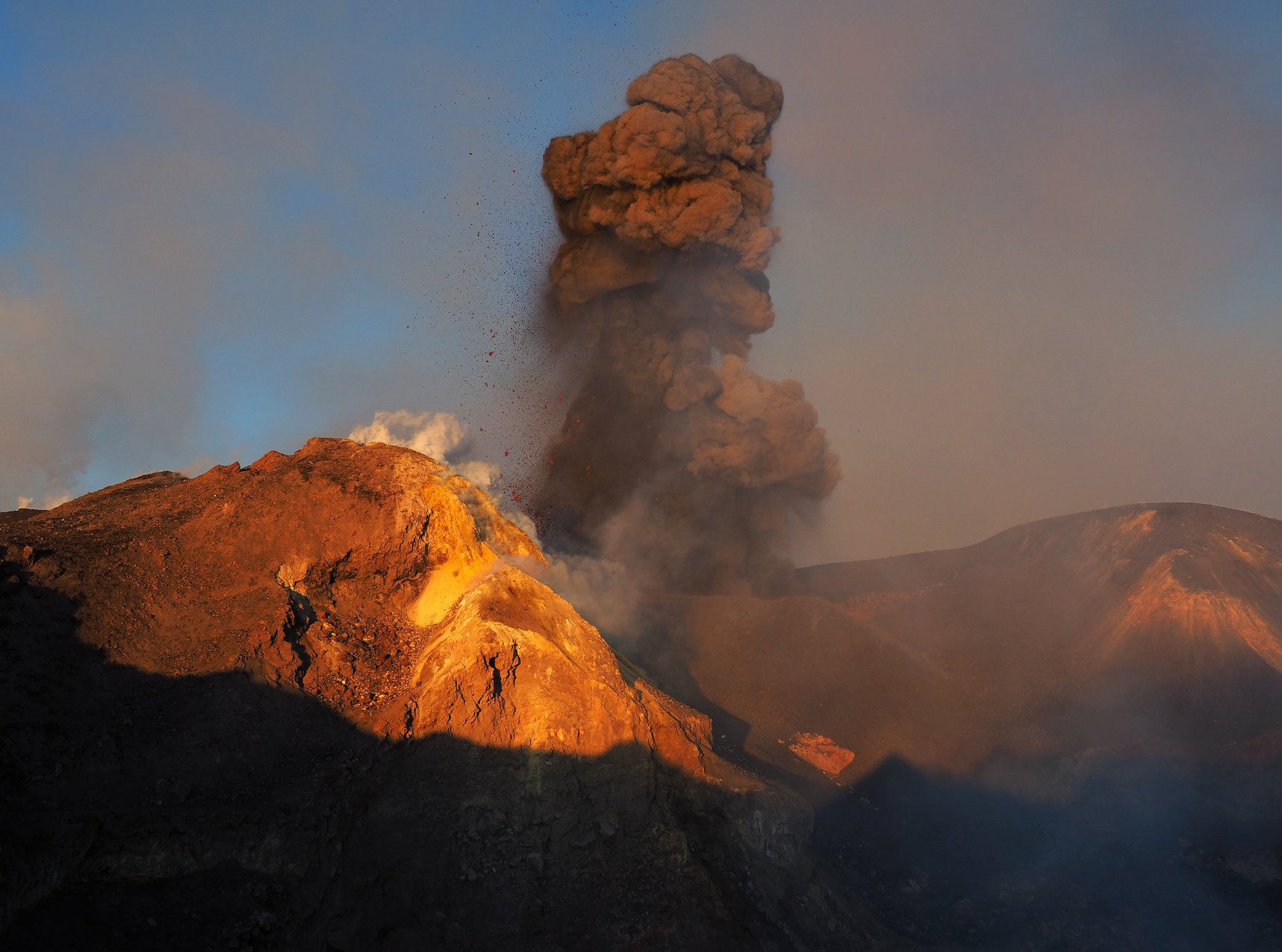
In the intra-crater area of Voragine, a strombolian-like rash continued. This activity was produced by two separate ash cones. In the main cone, active since September 12, 2019, the explosive activity was generated by a single mouth located in its summit crater and characterized by sporadic events of high intensity with bombs and shreds of lava projected between intervals of several minutes of rest.
https://www.facebook.com/GruppoGuideAlpineVulcanologicheEtnaNord/videos/144601980079371/
The second, smaller slag cone is located further east-south-east than the previous one. His eruptive activity was observed on the images of Mr. Cagliato’s camera since the evening of March 9, while his training probably dates back to a few days before the inspection, according to the volcanological guides. The cone was characterized by an animated explosive activity with frequent launching of bombs and large pieces of submetric lava generated by a single mouth placed on top of the cone. The launches reached several tens of meters above the mouth and fell beyond the southern edge of the crater of Bocca Nuova. In the northernmost part of the « saddle » between Voragine and the New South-East Crater, numerous bombs were found and sampled, still very fresh, probably emitted during certain phases of more intense activity that occurred within hours preceding the inspection. At the base of this new cone a small lava flow was visible, more supplied, whose forehead stopped at the base of the main cone. During the inspection, a third cone of slag was observed, which showed no signs of explosive activity; it is located to the northeast of the main cone and to the northwest of the new, very active cone. This cone is probably the product of Strombolian activity observed on February 29 (see report of 03/03/2020) at the northeast base of the main cone and continued until a few days ago as the show the photographic images of Mr. Cagliato.
The effusive activity emitted by a mouth placed on a large mound continued along the southeast side of the main cone. The well-fed lava flow after a few tens of meters is tunneled until it reaches the bottom of the Bocca Nuova where it continued to form the vast lava field that fills the depression of the crater. … / ..
Source : INGV .
Read the entire article : file:///C:/Users/Utilisateur/AppData/Local/Packages/Microsoft.MicrosoftEdge_8wekyb3d8bbwe/TempState/Downloads/BollettinoEtna20200317%20(1).pdf
Photo et video : Gruppo Guide Alpine e Vulcanologiche Etna Nord.
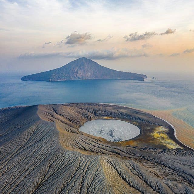
Indonesia , Anak Krakatau :
VOLCANO OBSERVATORY NOTICE FOR AVIATION – VONA.
Issued: March 18 , 2020
Volcano: Anak Krakatau (262000)
Current Aviation Colour Code: ORANGE
Previous Aviation Colour Code: orange
Source: Anak Krakatau Volcano Observatory
Notice Number: 2020KRA10
Volcano Location: S 06 deg 06 min 07 sec E 105 deg 25 min 23 sec
Area: Lampung, Indonesia
Summit Elevation: 502 FT (157 M)
Volcanic Activity Summary:
Eruption with volcanic ash cloud at 05h42 UTC (12h42 local).
Volcanic Cloud Height:
Ash-cloud is not visible
Other Volcanic Cloud Information:
Visuals directly from the cctv were observed eruptions with the color of the thick white-gray eruption smoke 300m from the top of the volcano, the wind direction slowlyto the south.
Remarks:
Eruption recorded on seismogram with maximum amplitude 42 mm and maximum duration 608 second.
Level of activity at level II (Waspada), since March 25, 2019. G. Anak Krakatau (157 m above sea level) has experienced an increase in volcanic activity since June 18, 2018, which was followed by » a series of eruptions in the period from September 2018 to February 2019. The last eruption occurred on February 11, 2020. with a height of eruption column not observed.
The volcano is clearly visible until it is covered with fog. No smoke from the crater is observed. The weather is sunny to cloudy, light winds from the east and southwest.
The seismographs of March 17, 2020 recorded:
3 harmonic tremors
Continuous tremor, amplitude 0.5 to 4 mm (dominant value of 1 mm)
Recommendation: People / tourists are not allowed to approach the crater within a radius of 2 km.
Source : Magma Indonésie , PVMBG.
Photo : picuki.com via Vulcanologia Esia .
Iceland , Thorbjorn :
The latest results of deformation around Mt. Thorbjorn on the Reykjanes peninsula indicate that inflation causing uplift in the area has started again. The uplift is slower than when measured in january, but seems to be in the same location. The most likely explanation for the signal is that inflow of magma started again.
Source : Vedur is.
Colombia , Nevado del Ruiz :
Weekly activity bulletin of the Nevado del Ruiz volcano
The level of activity continues at the level of yellow activity or (III): changes in the behavior of volcanic activity.
With regard to monitoring the activity of the Nevado del Ruiz volcano, the COLOMBIAN GEOLOGICAL SERVICE reports that:
According to the results obtained from the activity monitoring, across the different parameters, the Nevado del Ruiz volcano has continued to exhibit instability in its behavior during the last week.
The seismicity linked to the dynamics of the fluids, inside the volcanic conduits, presented a similar level in the number of recorded events and in the seismic energy released, compared to the previous week. This seismic activity was characterized by the occurrence of continuous volcanic tremors, earthquakes of the long period type (LP) and of the very long period type (VLP) recorded individually or jointly with pulses of volcanic tremor (TR). The earthquakes presented varying energy levels and spectral content. Some of these signs were associated with small emissions of gas and ash, which were confirmed by cameras installed in the volcano area, reports by staff of the Colombian Geological Service, officials of the Los Nevados National Natural Park in the region, and reports published by the VAAC (Current Volcanic Ash Advisories).
The seismicity generated by the fracturing of rocks (volcano-tectonic) maintained similar levels in the number of earthquakes and presented a slight increase in the seismic energy released, compared to the previous week. This type of seismicity was mainly located in the eastern sector, 3.0 km from the Arenas crater and, to a lesser extent, in the northeast and southeast sectors of the Arenas crater. The depth of the earthquakes ranged from 0.7 to 10.9 km. The occurrence of a slight seismic increase in this type of activity stands out, recorded between March 16 and 17 in the eastern sector at depths varying between 2.7 and 3.5 km. The maximum magnitude recorded during the week was 1.5 ML (local magnitude), corresponding to the earthquake recorded on March 17 at 05:39 (local time), located east of the Arenas crater, at 3, 3 km deep.
It is also worth noting the occurrence of several seismic episodes of the « drumbeat » type, volcano-tectonic earthquakes, of short duration and of very low energy level. This type of seismicity is linked to the process of ascension and evolution of domes on the surface of a volcano.
The deformation of the volcanic surface, measured from GNSS (Global Navigation Satellite System) stations, did not show any significant change or deformation process during the week. However, it is important to note that some minor changes have been observed in the data obtained by the inclinometers.
By monitoring the information provided on the Mirova and NASA FIRMS web portals, there have been reports of low to moderate energy thermal anomalies in the volcano over the past week.
Source : SGC.
Photo : Auteur Inconnu .