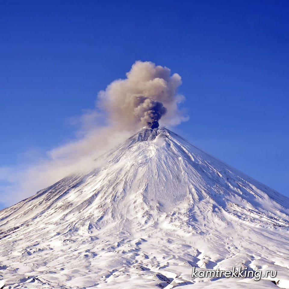
March 16, 2020. EN . Alaska : Semisopochnoi , Kamchatka : Klyuchevskoy , Vanuatu : Yasur , Ecuador : Sangay , Iceland : Grindavik .

March 16 , 2020 .


Alaska , Semisopochnoi :

AVO/USGS Volcanic Activity Notice

Current Volcano Alert Level: WATCH
Previous Volcano Alert Level: ADVISORY
Current Aviation Color Code: ORANGE
Previous Aviation Color Code: YELLOW
Issued: Sunday, March 15, 2020, 5:24 PM AKDT
Source: Alaska Volcano Observatory
Location: N 51 deg 55 min E 179 deg 35 min
Elevation: 2625 ft (800 m)
Area: Aleutians

Minor ash deposits on the south and west flanks of the north cone of Mount Cerberus, Semisopochnoi Island, Sept. 10, 2018, captured by ESA Sentinel-2. Also note probable minor steam emissions obscuring the crater of the north cone.

Volcanic Activity Summary:
Seismicity has been increasing the last few days at Semisopochnoi, and now is characterized by nearly continuous tremor and frequent small explosion signals. This represents a significant increase in activity and the Alaska Volcano Observatory is increasing the Aviation Color Code to ORANGE and the Volcano Alert Level to WATCH. No significant ash emissions have been detected in satellite images; clouds cover much of the island to around 10,000 ft. asl.

Recent Observations:
[Volcanic cloud height] n/a
[Other volcanic cloud information] n/a

Remarks:
Semisopochnoi is monitored with an on-island seismic network, and remotely by satellite and lightning sensors. An infrasound array on Adak Island could detect explosive emissions from Semisopochnoi with a 13 minute delay if atmospheric conditions permit.

Source : AVO .

Photo : waythomas, chris; ESA Sentinel-2.


Kamchatka , Klyuchevskoy :

VOLCANO OBSERVATORY NOTICE FOR AVIATION (VONA).

Issued: 20200315/0435Z
Volcano: Klyuchevskoy (CAVW #300260)
Current aviation colour code: ORANGE
Previous aviation colour code: orange
Source: KVERT
Notice Number: 2020-31
Volcano Location: N 56 deg 3 min E 160 deg 38 min
Area: Kamchatka, Russia
Summit Elevation: 15580 ft (4750 m)


Volcanic Activity Summary:
A moderate explosive eruption of the volcano continues, the Strombolian activity is noting. According to satellite data, a gas-steam plume containing some amount of ash is extending for 170 km to the north-east of the volcano.
This eruption continues. Ash explosions up to 16,400-23,000 ft (5-7 km) a.s.l. could occur at any time. Ongoing activity could affect low-flying aircraft.

Volcanic cloud height:
18040 ft (5500 m) AMSL Time and method of ash plume/cloud height determination: 20200315/0430Z – Video data

Other volcanic cloud information:
Distance of ash plume/cloud of the volcano: 106 mi (170 km)
Direction of drift of ash plume/cloud of the volcano: ENE / azimuth 60 deg
Time and method of ash plume/cloud determination: 20200315/0410Z – Himawari-8

Source : Kvert.

Photo : Kamtrekking via Sherine France .


Vanuatu , Yasur :

19°32’0”S 169°26’30”E
Summit 1184ft (361m)
Current Volcano Alert Level: Level 2

Yasur volcano activity has now increased in the major unrest state. The volcanic Alert Level remains at Level 2 .

New observations on the ground suggest that the Yasur volcanic activity emits plumes of ash and volcanic gases. With this current activity which consist of volcanic ash emissions from eruptive vents and presence of volcanic gases around the summit crater, the danger zone has increased to 600 meter around the volcanic cone.

Analysis of the latest Yasur seismic data from the volcano monitoring system confirms this increase in activity of the Yasur volcano at the major unrest state. The activity consists of ongoing explosions and emissions of ash plumes and volcanic gases. Some explosions remains intensified and volcanic projectiles or bombs may fall in and/or around the summit crater.

The Yasur Volcanic Alert Level (VAL) has been at the Level 2 since 18th October 2016. The current observations are consistent with the activity of the Volcanic Alert Level 2. Level 2 indicates ‘ Major level of unrest; Danger zone is now at 600 m around the volcanic cone ’. With this current volcanic activity, it is a useful reminder that eruptions can occur with little or no warning.

Source : Geohazard Vanuatu .

Photo : G Vitton.


Ecuador , Sangay :

DAILY REPORT OF THE STATE OF SANGAY VOLCANO, Sunday March 15, 2020.

Surface activity level: High, Surface trend: No change.
Internal activity level: High, Internal trend: No change.

Seismicity (events): From March 14, 2020, 11:00 a.m. to March 15, 2020, 11:00 a.m .:
Long Period Type (LP): 7 events
Explosions (EXP): 18 events.
Emission tremors (TE): 3

Rains / lahars: There was rain, with an additional yesterday’s lahar signal which lasted approximately 2 hours. Another indicator from Morona Santiago reported that there is a dam at the confluence of the Upano river with the Volcan river. This could be associated with the descent of the mudslides.

Emission / ash column: In the afternoon yesterday, a continuous emission of gas and ash was observed with a southwest direction and a height up to 1000 meters above the level of the crater.

Other monitoring parameters: At night, the remobilization of the deposits deposited on the south-eastern flank and the formation of pyroclastic flows were observed, as happened in the previous days.

Observations: For the moment, the volcano sector is cloudy.
Alert level: yellow.

Source : IGEPN.

Photo : John Arellano via Sherine France .


Iceland , Grindavik :

Yesterday morning an M3.2 earthquake was detected just N of Herðubreið. Over 150 earthquakes have been located there over the weekend. Around a week ago there were also around 100 earthquakes located there. Seismic swarms are common in this area, last time an earthquake above M3.0 was detected in similar area was in November 2019.

The earthquake swarm that started 12th of March NE of Grindavík is still ongoing, but the intensity of the swarm has decreased since in the beginning. Number of minor earthquakes are still being detected in the area. In the beginning of the swarm an M5.2 earthquake occurred about 5 km NE of Grindavík. During the first day of the swarm eight other earthquakes above M3.0 were detected. Uplift is no longer being observed in the area.

The uncertainty phase that Civil Protections declared is in force.

Source : IMO.


16 Mars 2020 . FR . Alaska : Semisopochnoi , Kamchatka : Klyuchevskoy , Vanuatu : Yasur , Equateur : Sangay , Islande : Grindavik .

16 Mars 2020 .


Alaska , Semisopochnoi :

Avis d’activité volcanique AVO / USGS

Niveau d’alerte volcanique actuel: ATTENTION
Niveau d’alerte volcan précédent: AVIS
Code couleur actuel de l’aviation: ORANGE
Code couleur de l’aviation précédent: JAUNE

Émis: dimanche 15 mars 2020, 17 h 24 AKDT
Source: Alaska Volcano Observatory
Emplacement: N 51 deg 55 min E 179 deg 35 min
Altitude: 2625 pieds (800 m)
Région: Aléoutiennes.

Petits dépôts de cendres sur les flancs Sud et Ouest du cône Nord du mont Cerberus, île Semisopochnoi, 10 septembre 2018, capturés par l’ESA Sentinel-2. Notez également les émissions de vapeur mineures probables obscurcissant le cratère du cône nord.

Résumé de l’activité volcanique:
La sismicité a augmenté ces derniers jours sur le Semisopochnoi et se caractérise maintenant par des tremors presque continus et de petits signaux d’explosion fréquents. Cela représente une augmentation significative de l’activité et l’Observatoire des volcans d’Alaska augmente le code de couleur de l’aviation à ORANGE et le niveau d’alerte du volcan à ATTENTION. Aucune émission significative de cendres n’a été détectée sur les images satellites; les nuages ​​couvrent une grande partie de l’île à environ 10 000 pieds d’altitude .

Observations récentes:
[Hauteur des nuages ​​volcaniques] n / a
[Autres informations sur les nuages ​​volcaniques] n / a

Remarques:
Le Semisopochnoi est surveillé avec un réseau sismique sur l’île et à distance par satellite et capteurs de foudre. Un réseau de capteurs d’infrasons sur l’île d’Adak pourrait détecter les émissions explosives du Semisopochnoi avec un retard de 13 minutes si les conditions atmosphériques le permettent.

Source : AVO .

Photo : waythomas, chris; ESA Sentinel-2.


Kamchatka , Klyuchevskoy :

AVIS D’OBSERVATION DU VOLCAN POUR L’AVIATION (VONA).

Émis: 15 Mars 2020 
Volcan: Klyuchevskoy (CAVW # 300260)
Code couleur actuel de l’aviation: ORANGE
Code couleur de l’aviation précédent: orange
Source: KVERT
Numéro de l’avis: 2020-31
Emplacement du volcan: N 56 deg 3 min E 160 deg 38 min
Région: Kamchatka, Russie
Altitude du sommet: 15580 pi (4750 m).


Résumé de l’activité volcanique:
Une éruption explosive modérée du volcan se poursuit, on constate la continuité de l’activité strombolienne. Selon les données satellitaires, un panache gaz-vapeur contenant une certaine quantité de cendres s’étend sur 170 km au Nord-Est du volcan.
Cette éruption continue. Des explosions de cendres jusqu’à 16 400-23 000 pi (5-7 km) d’altitude pourraient survenir à tout moment. L’activité en cours pourrait affecter les aéronefs volant à basse altitude.

Hauteur des nuages ​​volcaniques:
18040 ft (5500 m) AMSL Heure et méthode de détermination du panache de cendres / hauteur des nuages: 20200315 / 0430Z – Données vidéo

Autres informations sur les nuages ​​volcaniques:
Distance du panache de cendres / nuage du volcan: 170 km
Direction de la dérive du panache de cendres / nuage du volcan: ENE / azimut 60 deg
Heure et méthode de détermination du panache de cendres / nuages: 20200315 / 0410Z – Himawari-8.

Source : Kvert.

Photo : Kamtrekking via Sherine France .


Vanuatu , Yasur :

19 ° 32’0 ”S 169 ° 26’30” E
Sommet : 1184ft (361m)
Niveau d’alerte actuel du volcan : niveau 2

L’activité du volcan Yasur a maintenant augmenté à l’état de troubles majeurs. Le niveau d’alerte volcanique reste au niveau 2.

De nouvelles observations sur le terrain suggèrent que l’activité volcanique du Yasur émet des panaches de cendres et de gaz volcaniques. Avec cette activité actuelle qui consiste en des émissions de cendres volcaniques par des évents éruptifs et la présence de gaz volcaniques autour du cratère sommital, la zone de danger a été augmentée à 600 mètres autour du cône volcanique. 

L’analyse des dernières données sismiques Yasur du système de surveillance du volcan confirme cette augmentation de l’activité du volcan Yasur à l’état de troubles majeurs. L’activité consiste en des explosions et des émissions continues de panaches de cendres et de gaz volcaniques. Certaines explosions restent intenses et des projectiles ou bombes volcaniques peuvent retomber dans et / ou autour du cratère sommital.

Le niveau d’alerte volcanique Yasur (VAL) est au niveau 2 depuis le 18 octobre 2016. Les observations actuelles sont cohérentes avec l’activité du niveau d’alerte volcanique 2. Le niveau 2 indique «Niveau d’agitation majeur; La zone de danger est maintenant à 600 m autour du cône volcanique ». Avec cette activité volcanique actuelle, c’est un rappel utile que les éruptions peuvent se produire avec peu ou pas d’avertissement.

Source : Geohazard Vanuatu .

Photo : G Vitton.


Equateur , Sangay :

RAPPORT QUOTIDIEN DE L’ETAT DU VOLCAN SANGAY , Dimanche 15 Mars 2020 .

Niveau d’activité Superficiel: Haut , Tendance de surface : Pas de changement .
Niveau d’activité interne: Haut , Tendance interne : Pas de changement.

Sismicité (événements): Du 14 Mars 2020, 11:00 au 15 Mars 2020, 11:00 :
Type Longue Période (LP): 7 événements
Explosions (EXP): 18 événements.
Tremors d’émission ( TE) : 3

Pluies / lahars: Il y a eu des pluies, avec en plus , hier après-midi , un signal de lahar qui a duré environ 2 heures. Un autre indicateur de Morona Santiago a signalé qu’il y a un barrage au confluent de la rivière Upano avec la rivière Volcan . Cela pourrait être associé à la descente des coulées de boue.

Emission / colonne de cendres: Dans l’après-midi d’hier, une émission continue de gaz et de cendres a été observée avec une direction Sud-Ouest et une hauteur pouvant atteindre 1000 mètres au-dessus du niveau du cratère.
Autres paramètres de surveillance: La nuit, la remobilisation des dépôts déposés sur le flanc Sud-Est et la formation de coulées pyroclastiques ont été observées, comme ce qui s’est produit les jours précédents.

Observations: Pour le moment, le secteur du volcan est nuageux.

Niveau d’alerte: jaune.

Source : IGEPN.

Photo : John Arellano via Sherine France .


Islande , Grindavik :

Hier matin, un tremblement de terre de M3.2 a été détecté juste au nord de Herðubreið. Plus de 150 tremblements de terre y ont été localisés ce week-end. Il y a environ une semaine, une centaine de tremblements de terre y ont également été localisés. Des essaims sismiques sont communs dans cette zone, la dernière fois qu’un tremblement de terre au-dessus de M3.0 a été détecté dans une zone similaire , c’était en novembre 2019.

L’essaim de tremblements de terre qui a commencé le 12 mars au Nord-Est de Grindavík est toujours en cours, mais l’intensité de l’essaim a diminué depuis le début. De nombreux tremblements de terre mineurs sont encore détectés dans la région. Au début de l’essaim, un tremblement de terre de M5,2 s’est produit à environ 5 km au Nord-Est de Grindavík. Au cours du premier jour de l’essaim, huit autres tremblements de terre au-dessus de M3.0 ont été détectés. Le soulèvement n’est plus observé dans la région.

La phase d’incertitude déclarée par la Protection civile reste en vigueur.

Source : IMO.