September 18 , 2021.
Spain / La Palma , Cumbre Vieja :
ON THE STABILITY OF CUMBRE VIEJA, LA PALMA
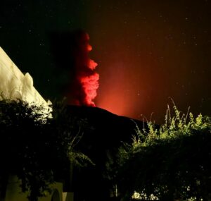
The recent volcanic reactivation of La Palma has again raised the debated question of the stability of the western flank of the island and, in particular, of the volcanic edifice of Cumbre Vieja, a recurring problem for decades, raising concerns in the company.
For 20 years, when some researchers asserted the possibility that a great collapse of the western flank of Cumbre Vieja could occur and consequently the generation of a mega-tsunami, the fear of such a catastrophic event spread. Despite the fact that this hypothesis was refuted and then dismissed by many researchers, surprisingly, some media continue to speak of this catastrophic event of a large gravitational slide on the western flank of the Cumbre Vieja volcano.
This hypothesis implied the existence of a surface of geological weakness of great extension, continuity and depth, consisting of a basal layer formed by material from previous landslides, what is called mortar, and the presence of ‘an almost vertical fracture with an approximately north-south direction, tens of kilometers long and several kilometers deep, which would limit the alleged Cumbre Vieja landslide on the east side.
The mortar course has been verified in numerous galleries, shafts, tunnels and boreholes. Regarding the great fracture, neither its continuity nor its depth has been determined, so the conditions on which the theory of sliding mainly rests will not go beyond a simple hypothesis. However, if the strength properties of the mortar are taken into account, the current geometry of the island, the geological structure, the inclination of the layers, etc., Cumbre Vieja would be stable even against future eruptive episodes and the associated seismicity, according to the geo-mechanical models and the stability analyzes carried out, where the magma injection pressures, the seismic accelerations, the influence of pore pressures, etc. have been taken into account.
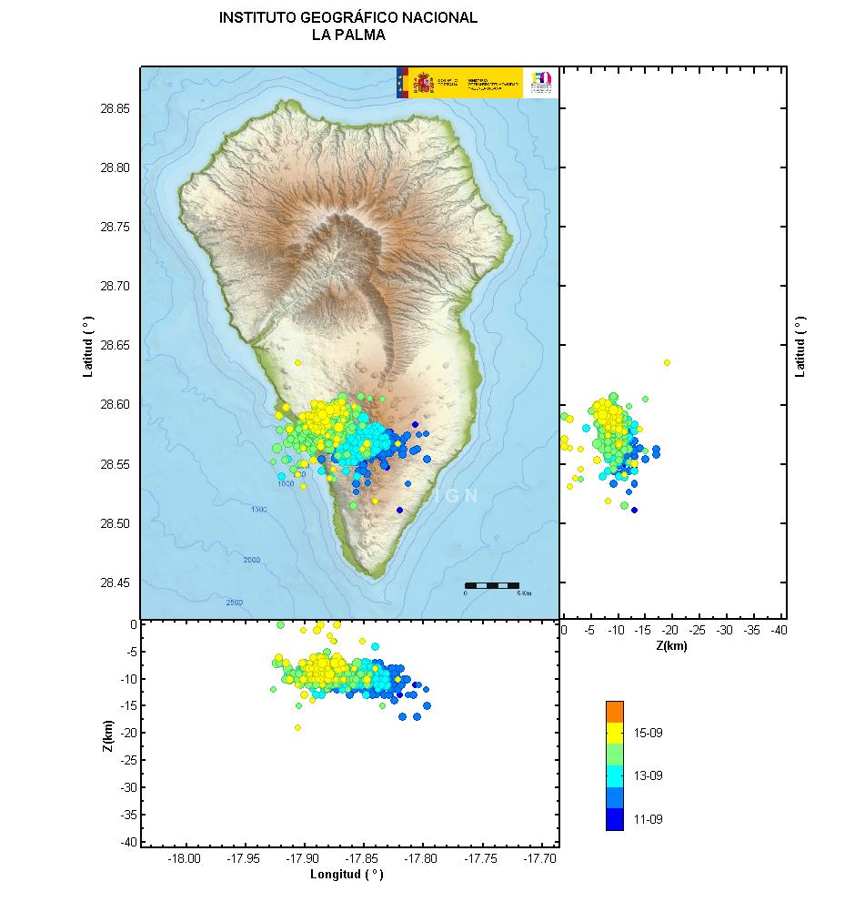
For the Cumbre Vieja flank to meet near instability conditions, an exceptionally high magnitude earthquake and a large-scale explosive volcanic eruption would have to occur simultaneously, or the current volcanic building would have to grow to at least 1,000 meters in its growth. natural, current maximum altitude. To reach this height would take more than 40,000 years, taking as a benchmark the average growth rate of the island over the last million years. In contrast, the likelihood of a high explosive index eruption occurring at the same time as a large earthquake is extremely low, according to geological records of this type of event on the island. Therefore, Cumbre Vieja is stable even under the effects of eruptions similar to those which have occurred in the last tens of thousands of years.
These results are part of several research projects on large gravitational landslides and megatsunamis, in which researchers from the Canary Islands Volcanological Institute (INVOLVCAN) have participated in a relevant way.
Source : Involcan / Luis González de Vallejo
Director of the Geological Risks Zone of INVOLCÁN
Honorary professor at the Complutense University of Madrid (UCM)
Photo : Sergio Socorro.
Alaska / Aleutian Islands , Great Sitkin :
52°4’35 » N 176°6’39 » W,
Summit Elevation 5709 ft (1740 m)
Current Volcano Alert Level: WATCH
Current Aviation Color Code: ORANGE
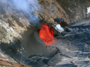
Lava effusion continued at Great Sitkin this week. The growing lava dome has now reached the south and west summit crater rims. A satellite radar image from September 16 shows that the dome currently has dimensions of about 1130 m (3700 ft) east-west and about 910 m (3000 ft) north-south, and is about 30 m (100 ft) thick. Seismicity remains elevated with small earthquakes consistent with lava effusion continuing. Elevated surface temperatures were observed in clear satellite images over the past week. No explosive activity or ash emissions have been detected in seismic, infrasound and satellite data.
Summit crater of Great Sitkin volcano, May 30, 2021. Dark linear feature in middle foreground is a lahar (volcanic mudflow) deposit. Note trace ash fall over snow on right flank of Great Sitkin summit. The dark deposits in the summit crater are likely ash fall and pyroclastic flow deposits.
There is no indication of how long lava effusion will continue during the current eruption, and it is possible that explosive activity could occur with little or no warning.
Great Sitkin Volcano is monitored by local seismic and infrasound sensors, satellite data, web cameras, and remote infrasound and lightning networks.
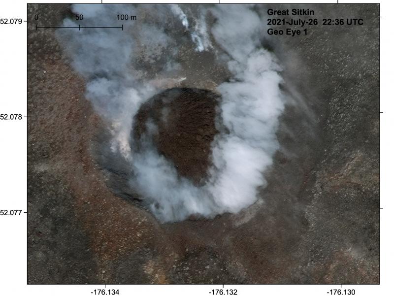
Great Sitkin crater with a new circular lava dome, imaged on July 26, 2021. Dome was about 130 m diameter.
Great Sitkin Volcano is a basaltic andesite volcano that occupies most of the northern half of Great Sitkin Island, a member of the Andreanof Islands group in the central Aleutian Islands. It is located 43 km (26 miles) east of the community of Adak. The volcano is a composite structure consisting of an older dissected volcano and a younger parasitic cone with a 3-km-diameter summit crater. A steep-sided lava dome, emplaced during the most recent significant eruption in 1974, occupies the center of the crater. That eruption produced at least one ash cloud that likely exceeded an altitude of 25,000 ft above sea level. A poorly documented eruption occurred in 1945, also producing a lava dome that was partially destroyed in the 1974 eruption. Within the past 280 years a large explosive eruption produced pyroclastic flows that partially filled the Glacier Creek valley on the southwest flank.
Source : AVO
Photos : Rhodes, Steve , ( 30 Mai 2021.) , Loewen, Matt .
Kamchatka , Karymsky :
VOLCANO OBSERVATORY NOTICE FOR AVIATION (VONA)
Issued: September 17 , 2021
Volcano: Karymsky (CAVW #300130)
Current aviation colour code: ORANGE
Previous aviation colour code: orange
Source: KVERT
Notice Number: 2021-115
Volcano Location: N 54 deg 2 min E 159 deg 26 min
Area: Kamchatka, Russia
Summit Elevation: 1486 m (4874.08 ft)
Volcanic Activity Summary:
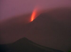
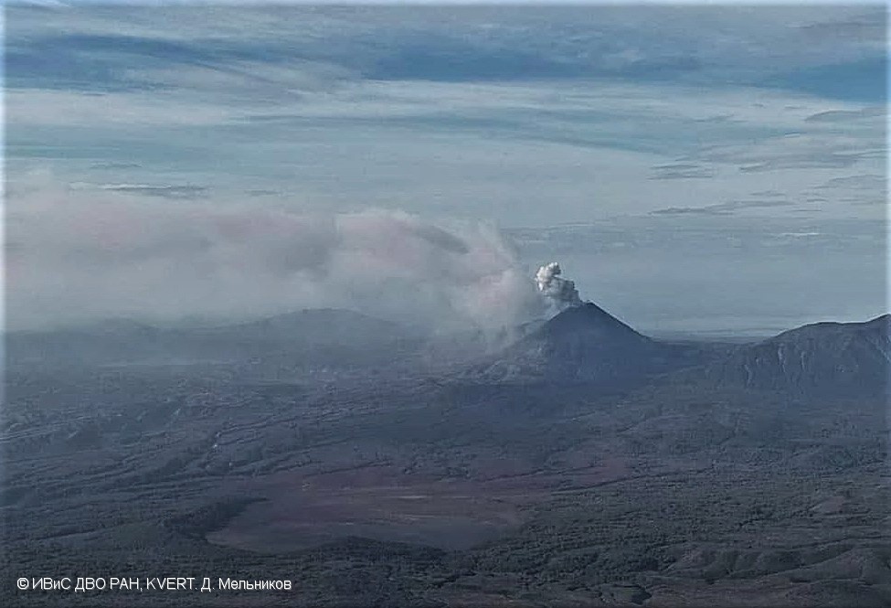
A moderate eruptive activity of the volcano continues. According to satellite data, an ash plume is extending for 38 km to the east of the volcano.
This activity continues. Ash explosions up to 19,700-23,000 ft (6-7 km) a.s.l. could occur at any time. Ongoing activity could affect low-flying aircrafts.
Volcanic cloud height:
2000-2500 m (6560-8200 ft) AMSL Time and method of ash plume/cloud height determination: 20210917/2220Z – Himawari-8
Other volcanic cloud information:
Distance of ash plume/cloud of the volcano: 38 km (24 mi)
Direction of drift of ash plume/cloud of the volcano: E / azimuth 84 deg
Time and method of ash plume/cloud determination: 20210917/2220Z – Himawari-8
Source : Kvert.
Photo : D. Melnikov, IVS FEB RAS, KVERT
Indonesia , Merapi :
Report on the activity of Mount Merapi, September 10-16, 2021.
I. RESULTS OF OBSERVATIONS
Visual
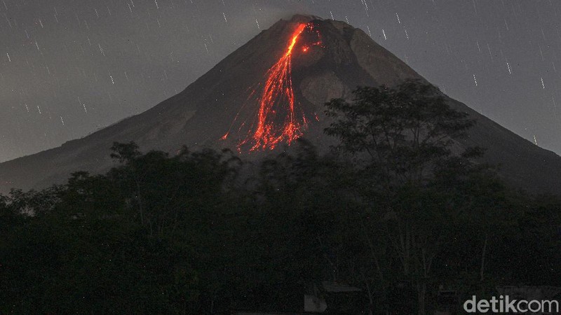
The weather around Mount Merapi is generally sunny in the morning and evening, while it is foggy in the afternoon. White fumes, weak to thick, of low pressure and 400 m high were observed from the observation post of Mount Merapi in Babadan on September 15, 2021 at 5:15 a.m. WIB. Lava avalanches were observed 144 times southwest with a maximum slide distance of 2000 m.
No significant morphological changes were observed in the southwest and central lava domes. The volume of the southwest lava dome is 1,550,000 m3 and the central dome is 2,854,000 m3.
Seismicity
This week, the seismicity of Mount Merapi showed:
2 shallow volcanic earthquakes (VTB),
303 low frequency earthquakes (LF),
16 multi-phase earthquakes (MP),
1,559 avalanche earthquakes (RF),
1,277 emission earthquakes (DG),
1 tectonic earthquake (TT).
The intensity of this week’s seismicity is still quite high.
Deformation
The deformation of Mount Merapi which was monitored using EDM and GPS this week showed no significant changes.
Rains and lahars
This week, it rained at the Mount Merapi observation post with an intensity of 46 mm / hour for 155 minutes at Kaliurang post on September 11, 2021. There were no reports of lahars or additional flow in the mountains. rivers that take their source on Mount Merapi.
Conclusion
Based on the results of visual and instrumental observations, it is concluded that:
The volcanic activity of Mount Merapi is still quite high in the form of effusive eruption activity. The status of the activity is defined in the “SIAGA” level.
Source : BPPTKG
Photo : detik .com
Ecuador , Reventador :
DAILY REPORT OF THE STATE OF THE REVENTADOR VOLCANO, Friday September 17, 2021.
Information Geophysical Institute – EPN.
Surface activity level: High, Surface trend: No change.
Internal activity level: Moderate, Internal trend: No change.
Seismicity: From September 16, 2021, 11:00 a.m. to September 17, 2021, 11:00 a.m.
Explosions (EXP): 70 events
Long period type events (LP): 45
Tremors of emissions (TREMI): 5
Harmonic Tremors (TRARM): 3.
Rains / lahars: Rains were recorded in the area which did not generate lahars.
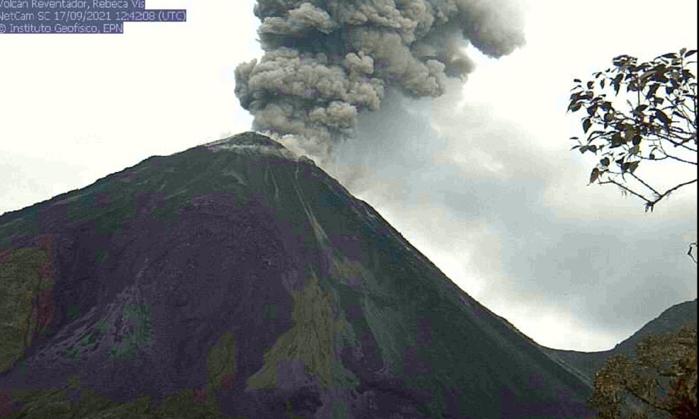
Emission / ash column: Various gas and ash emissions have been observed up to 1000 meters above crater level in a northwest and west direction. The VAAC reported 3 emission alerts observed by satellites from a height of 988 meters above crater level in a northeast and west direction.
Other monitoring parameters: There was no change in the other monitoring parameters and no thermal alerts were recorded by the satellites.
Observations: At night, an incandescence was observed in the upper part, in addition to the rolling of incandescent blocks up to 500 meters below the level of the crater on the sides of the volcano. At the moment the area of the volcano is cloudy.
Alert level: Orange.
Source et photo : IG-EPN.