July 15 , 2019.
Italy , Stromboli :
The paroxysm of Stromboli of July 3, 2019 and the activity of the following days: the point of the situation to July 13, 2019.
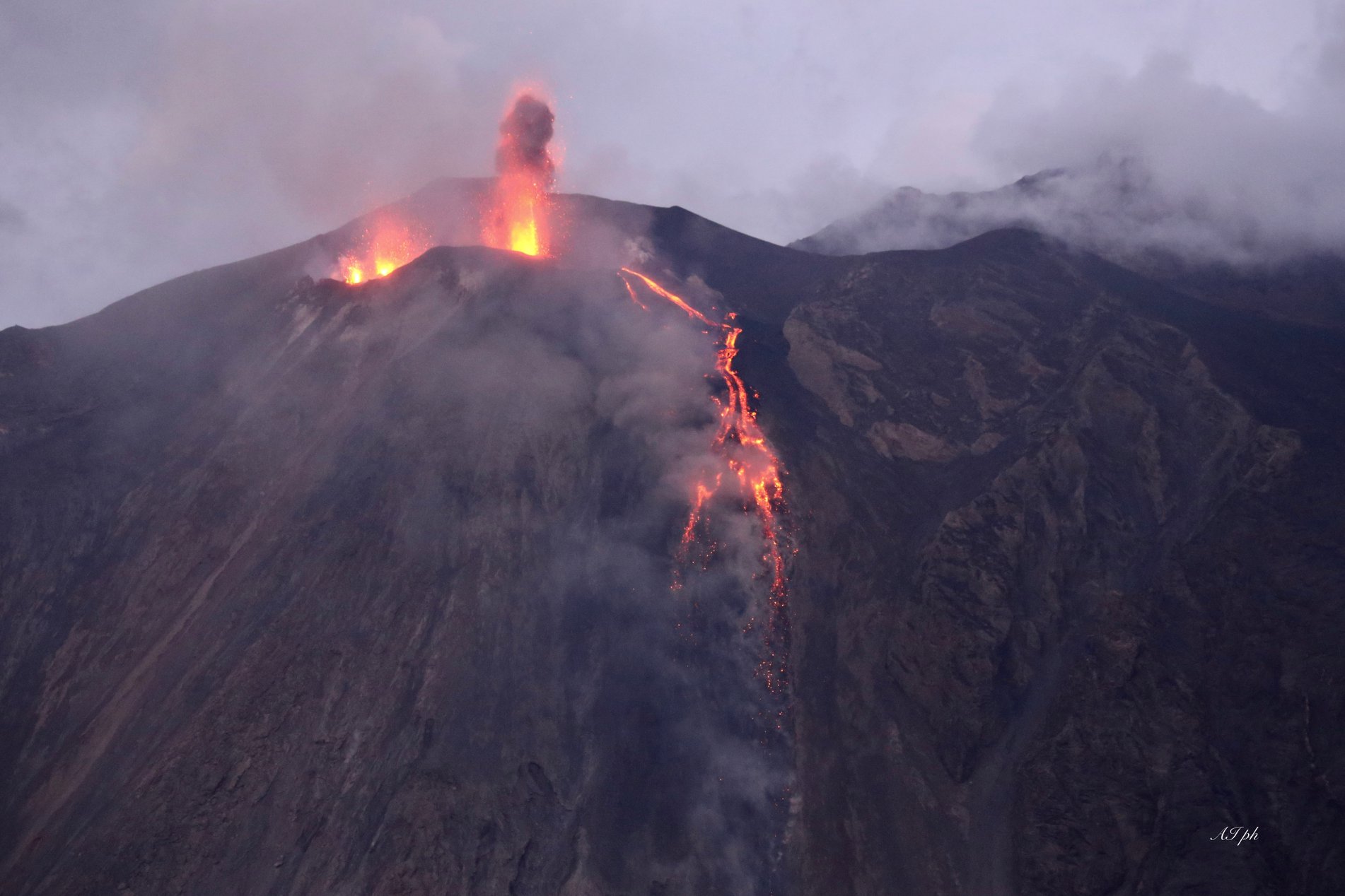
Over the past few months, the persistent explosive activity of Stromboli – in fact the classic « Strombolian activity » – has been quite lively, involving 4 or 5 mouths on the crater terrace. This activity reached its first climax on June 25, 2019 at 23:03 UTC (= local time -2), with a major explosion occurring in the Center-South zone of the Stromboli crater terrace (Figure 1). From the surveillance cameras, it was observed that pyroclastic materials fell along the Sciara del Fuoco and inside the crater terrace with blocks that also exceeded its edge.
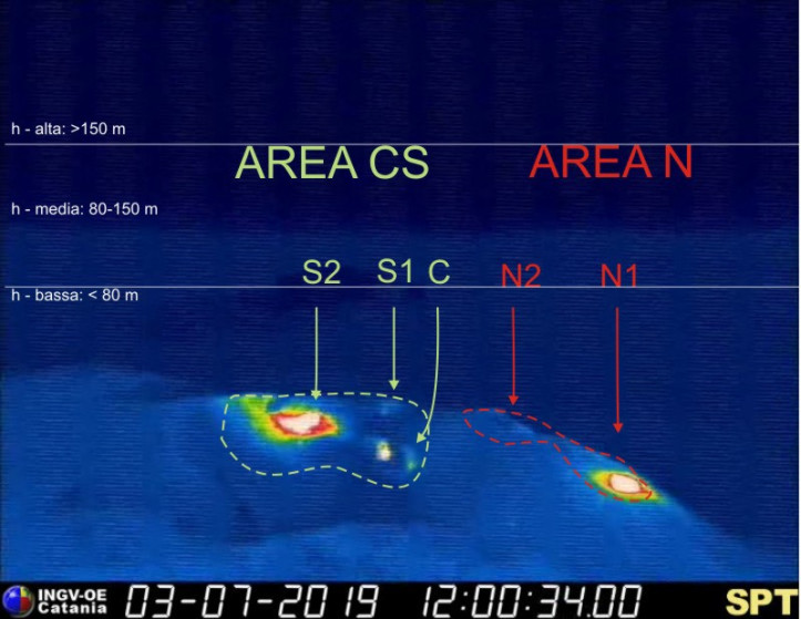
Figure 1. – Thermal image of Stromboli crater terrace, with initials applied to active vents. S1, S2 and C are located in the south-central crater (CS) zone, N1 and N2 in the north (N) zone. The view is taken from the Pizzo , northwest (INGV-OE).
The following days, the activity continued very vividly (see the video recorded on the evening of June 29 by Micol Todesco), including the southernmost vent of the Center-South zone of the terrace of crater produced frequent incandescent slag throwing that exceeded the height of the Pizzo.
The testimonies of those who observed Stromboli’s activity in the days of July 1 to 2 indicate that the activity had slightly decreased compared to previous days; this often occurs between one period of more intense activity and another and can not be considered as a precursor sign of the paroxysm of July 3rd. Even on July 3, until the afternoon, the eruptive activity showed no significant change. A small lava flow was emitted from the South Central crater area at the top of the Sciara del Fuoco around 14:00 UTC.
The paroxysm of July 3, 2019.
The first signal that can be interpreted as clearly associated with the paroxysm was recorded as a significant variation of the SVO dilatometric station, located at the COA center of San Vincenzo, at an altitude of 74 m above sea level, from from 14:38 UTC approximately. In the images of the thermal surveillance camera on the Pizzo (SPT), we note the emission of a small flow of lava from the mouth « C » (Figures 1 and 2a) at 14h43h15. During the two consecutive minutes, all the mouths began to emit lava flows (Fig. 2b-d); finally, at 14:45:43, a huge lava bubble quickly relaxed from the S1 and S2 mouth areas, starting the sequence of paroxysmal explosions, which lasted about a minute.
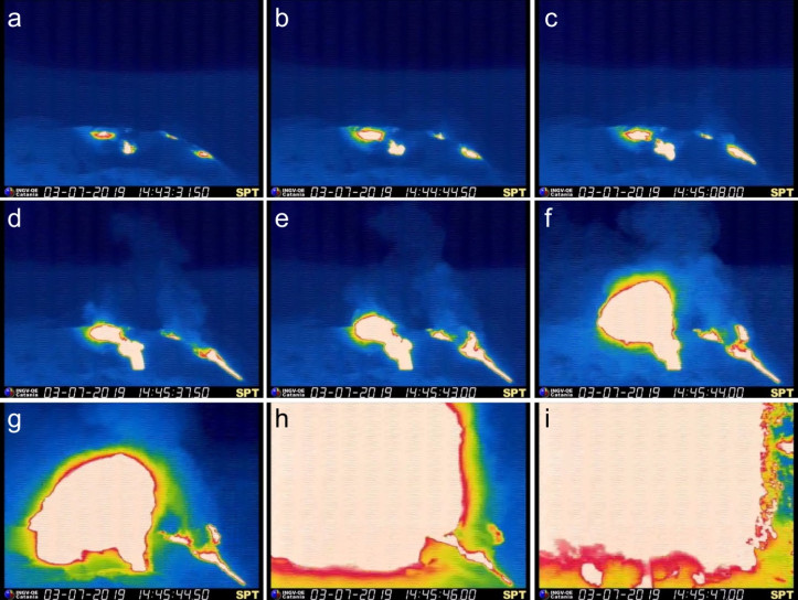
Figure 2. – The last three minutes of recording of the thermal camera of the INGG-OE « SPT » on Pizzo Stromboli, July 3, 2019, at 14:43: 30 – 14:45:47. We see the increase in eruptive activity (emission of lava flows from all vents) within 60 seconds before the onset of the breakthrough. This camera was destroyed by the same explosion, like many other surveillance tools.
The sequence of explosions was quite complex, generating, among other things, two explosions characterized by a certain directional orientation. The most violent event, at 4:46:40 pm, concerned the entire terrace of the crater. The collapse of a portion of the eruptive column on the Sciara del Fuoco generated at least two pyroclastic flows that spilled into the sea and progressed to about 1 km from the coast (Figure 3a). The eruption column rose about 4 km above the top of the volcano (924 m high, Figure 3b). The fallout from glowing pyroclastic materials quickly ignited vegetation on the slopes of the volcano (Figure 3c), particularly on the Ginostra side, the smaller of the two inhabited areas of the island, located in the southwestern sector of Stromboli ( Figure 4). ). Unfortunately, a 35-year-old man from Milazzo, who was with a friend in the Punta dei Corvi area (about 100 meters above sea level), died and his friend was injured.
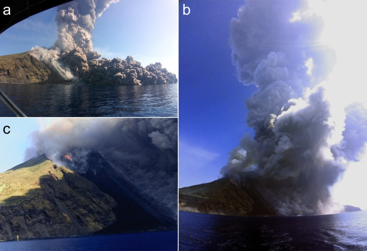
Figure 3. – At the time of the explosion of 3 July 2019, a German sailing ship was located about 2 km from the north coast of Stromboli. a) The two pyroclastic streams that spilled over the Sciara del Fuoco extended over the sea up to about 1 km from the coast. (b) Column eruption and continuous descent of hot materials on the Sciara del Fuoco. (c) Fires in the area of the ship; at the bottom left you see one of two buoys of marine wave measurements from the University of Florence for tsunami detection off the coast of the island. The photos were taken by Egon Karcher and reproduced here with the kind permission of the author.

Figure 4. – Vegetation devastated by fires caused by the July 3, 2019 explosion in the Ginostra region. Fortunately, the houses in the city have been spared. Photos taken by Boris Behncke, July 9, 2019 (INGV-OE).
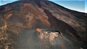
On the Pizzo, the fallout of coarse pyroclastic materials completely covered the ground, destroying the control tools that were there. On the external face of the Pizzo (South-East slope), the abundant recurrence of still fluid lava shells generated a small « reomorphic » flow, that is to say constituted of a pyroclastic material in the plastic state which clumps together and manages to sink. This stream covered about 200 to 300 m, covering the path usually taken by groups of day-trippers descending from Pizzo (Figure 5).
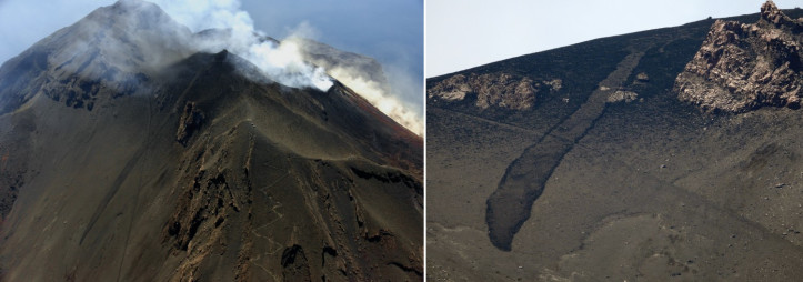
Figure 5. – Aerial photo (left) and sea view (right) of a small rheomorphic stream formed on the upper south-eastern flank of Stromboli and propagated in the Rina Grande, also known as « Sciara Vecchia « , during the paroxysm of July 3, 2019. The line that is cut diagonally to the casting is that used by hikers of Pizzo. The photos were taken by Stefano Branca on July 5th and by Boris Behncke on July 9th, 2019 (INGV-OE).
The impact of smaller pyroclastic materials (ash and lapilli) mainly affected the western sector of the island, including the built-up area of Ginostra (Figure 6). This material is largely composed of golden-colored slag (also known as « blonde pumice »), which has a mixture with black lava – a phenomenon typically observed in the products of Stromboli’s paroxysms. Many of these slags are extremely porous and float on the sea (Fig. 6a); in the following days, this waste was transported by sea currents to the south, beyond the island of Vulcano.
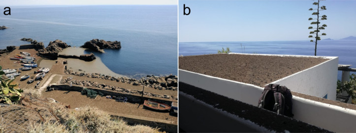
Figure 6. – (a) The small port of Ginostra covered with pyroclastic material (lapilli and ash), which also floats on the sea, on July 4, 2019. (b) Pyroclastic deposit on the roof of a house in Ginostra, the July 7, 2019. Photo by Gianfilippo De Astis (INGV-RM1).
Eruptive activity after the paroxysm until July 13, 2019.
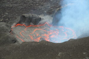
Following the sequence of paroxysmal explosions, there was a rapid decrease in explosive activity, which resumed less than an hour later with its usual characteristics, although very intense and accompanied by modest lava spills from different mouths placed on the crater terrace. In particular, the Center-South zone of the crater was the site of an almost continuous explosive activity of different mouths and the emission of small lava flows that flowed into the southern part of the Sciara del Fuoco, reaching about half slope (Figure 7).
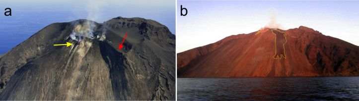
Figure 7. – Lava overflow on the upper Sciara del Fuoco, 5 July 2019. (a) Aerial photo taken by Stefano Branca (INGV-OE); the yellow arrow shows a small overflow of the northern crater area, the largest red arrow in the south-central crater area. b) The Sciara del Fuoco seen from the sea at sunset; both flows are surrounded by yellow lines. Photo of Francesco Ciancitto (INGV-OE)
On July 9, researchers at the INGV-Etneo Observatory and the GEOMAR Helmholtz Kiel Oceanographic Research Center in Germany conducted aerial photogrammetric surveys using a WINGCOPTER hybrid drone equipped with a Workswell thermal imaging camera ( WIRIS model) and a Sony 40 MP RGB camera. A preliminary 3D thermal model of the island and in particular of the area affected by the eruption was thus produced. In FIG. 8a, it is possible to clearly distinguish the active parts of the lava field and the zone of the summit affected by an explosive activity (in red). Figure 8b, on the other hand, shows an image taken on July 12 on the Sentinel-2 satellite, with three strong thermal anomalies corresponding to the mouths in explosive activity and the active lava flow in the upper part of the Sciara del Fuoco.
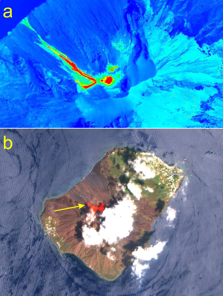
Figure 8. – (a) 3D thermal model of the Sciara del Fuoco and the upper part of Stromboli (images of 10:40 of July 9, 2019). In red, we highlight the part of the active flux emitted by the area of the south-central crater and the eruptive vents characterized by explosive activity. Note the large number of small active mouths in the North crater area. Data processed in collaboration with the GEOMAR Ocean Research Center Helmholtz Kiel, Germany. (b) Image taken from the Sentinel-2 satellite on July 12, 2019. There are thermal anomalies corresponding to the explosive mouths at the top and overflow of active lava (yellow arrow). Image of the European Union, Copernicus Sentinel data, processed by Annamaria Luongo.
At the time of publication of this article (evening of July 13, 2019), Stromboli continues an intense explosive and effusive activity. On the evening of July 12th, mouth activity in the North crater area increased, generating a series of small overflows in the upper central part of the Sciara del Fuoco (Figure 9a), while modest lava flows continued in the South Central crater area (Figure 9b).
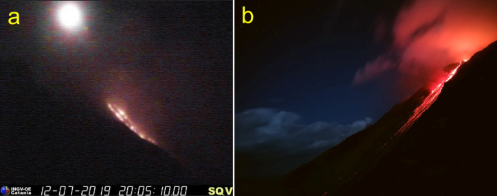
Figure 9. – (a) Overflow of the northern crater on the evening of July 12, 2019. Image recorded by the INGV-OE visual surveillance camera at an altitude of 400 m on the north side of the Sciara del Fuoco; above, you can see the near-full moon. b) Overflow of lava from the south-central zone, seen from Punta Corvo, during the night of July 12 to 13, 2019. Photo by Francesco Ciancitto (INGV-OE).
We thank all the INGV staff members who during this period made observations, sampled and restored damaged instruments on the island of Stromboli and shared their images. The collaboration of German colleagues from the GEOMAR Helmholtz Ocean Research Center in Kiel, Germany, was also valuable. A special thank you to Mr. Egon Karcher, who made available his precious photographs of the pyroclastic flows of Sciara del Fuoco of July 3, 2019.
Article written by Boris Behncke, using data obtained from monitoring networks and INGV staff involved in field activities and observatories operating rooms.
Source : INGV Vulcani.
Read the original article : https://ingvvulcani.wordpress.com/2019/07/13/il-parossismo-dello-stromboli-del-3-luglio-2019-e-lattivita-nei-giorni-successivi-il-punto-della-situazione-al-13-luglio-2019/?fbclid=IwAR0Y9bQHTc0jLzeV6o64VXTVcwlb8Qg7VA3iCsCQrI1A2buTT3GT6k_1ObU
Photo added : Iacullo Antonio
Chile , Nevados de Chillan :
Special report of volcanic activity (REAV).
Nuble Region, Nevados Volcano of Chillan, July 14, 2019, 07:30 local time (mainland Chile).
The National Geological and Mining Service of Chile (Sernageomin) publishes the following PRELIMINARY information, obtained from monitoring equipment of the National Volcanic Monitoring Network (RNVV), processed and analyzed at the Volcanological Observatory of the Southern Andes (OVDAS) :
Yesterday, Sunday, July 14, 2019 at 06:57 local time (10:57 UTC), the monitoring stations installed near the Nevados volcano of Chillan recorded an explosive event associated with a long period type earthquake (Type LP) which was related to the fluid dynamics inside the volcano.

The location of the earthquake after its analysis is:
TIME OF ORIGIN: 06h57 Local time (10h57 UTC)
LATITUDE: 36,870 ° S
LONGITUDE: 71.374 ° W
DEPTH: 0.8 KM
REDUCED MOVEMENT: 765 cm2
ACOUSTIC SIGNAL: 3.8 Pa reduced to 1 km
OBSERVATIONS:
The explosion was associated with the recording of a seismic signal with a reduced displacement value (mean seismic energy) of 765 cm2, considered high. Also, there was an incandescent associated with emissions of gas and pyroclastic materials at high temperatures, which were deposited in the vicinity of the crater.
The level of volcanic technical alert remains at the level: ORANGE.
Sernageomin continues online monitoring and will inform in a timely manner about any changes observed.
Source : Sernageomin.
Photo : Publimetro.
Russia / Kuril Islands, Raikoke :
News (rare) from Raikoke:
A report by Chris Burkard.
Yesterday we arrived at the newly erupted Raikoke island that had literally just exploded week ago. We were the first media team to document it. I had no clue that this island had mostly been cliffs before we arrived ..
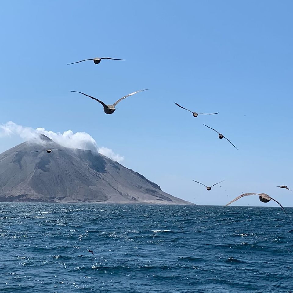
Almost zero sandy beaches. We walked along virgin shores while steam rose through the sand & burnt the soles of our shoes. Ash in the air stung as it entered our lungs & eyes while we walking along what was once a completely green and lush island. (Google what it used to look like) What became very evident was that this volcano had destroyed any chance of life to continue to thrive on the island. Hundreds of thousand of displaced sea birds were in the sky & water with many dead on the beach.
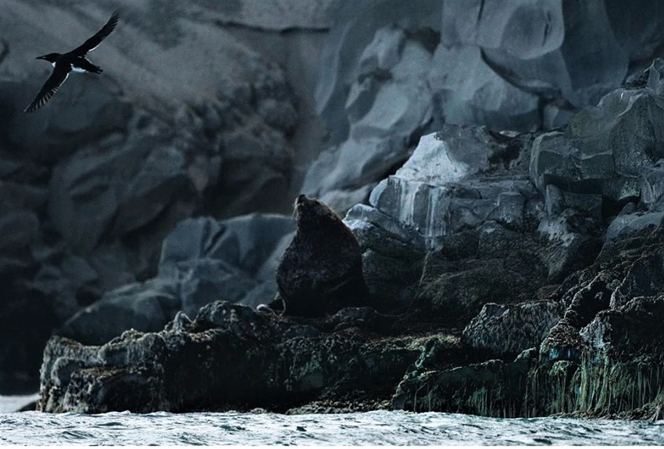
Vladimir our Russian scientist on board confirmed that the Sea Lion rookery had been wiped out leaving only a few stubborn males behind, his camera traps and observation hut also buried in ash. Dead seaweed from the changed ocean PH lined the rocks where we took samples of ash. It was altogether beautiful & terrifying.
Source : Chris Burkard / Facebook via Sherine France.
Photos : Olga Rumyantseva via Sherine France.
Mexico , Popocatepetl :
July 14, 11:00 am (July 14, 16:00 GMT).
During the last 24 hours, thanks to the surveillance systems of the Popocatépetl volcano, 77 exhalations have been identified, accompanied by steam, gas and light amounts of ash as well as 531 minutes of tremors accompanied by small amounts of ash. In addition, two low-intensity explosions were recorded yesterday at 5:58 pm and 7:58 pm. Due to cloud conditions, emissions could not be observed.
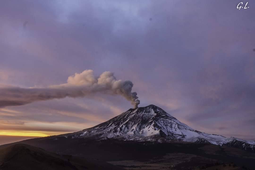
At the time of writing this report, there was an emission of water vapor and gas with small amounts of ash towards the West-South-West.
CENAPRED urges NOT to APPROACH the volcano and especially the crater, because of the risk of falling ballistic fragments, and in case of heavy rains, to move away from the bottom of the ravines because of the risk of mudslide and debris.
The Popocatepetl warning light is located at YELLOW PHASE 2.
Source : Cenapred .
Photo : GL , Volcan popo