March 03 , 2020 .
Indonesia , Merapi :
VOLCANO OBSERVATORY NOTICE FOR AVIATION – VONA.
Issued: 20200302/2250Z
Volcano: Merapi (263250)
Current Aviation Colour Code: RED
Previous Aviation Colour Code: orange
Source: Merapi Volcano Observatory
Notice Number: 2020MER03
Volcano Location: S 07 deg 32 min 31 sec E 110 deg 26 min 31 sec
Area: Special Region of Yogyakarta, Indonesia
Summit Elevation: 9498 FT (2968 M)
Volcanic Activity Summary:
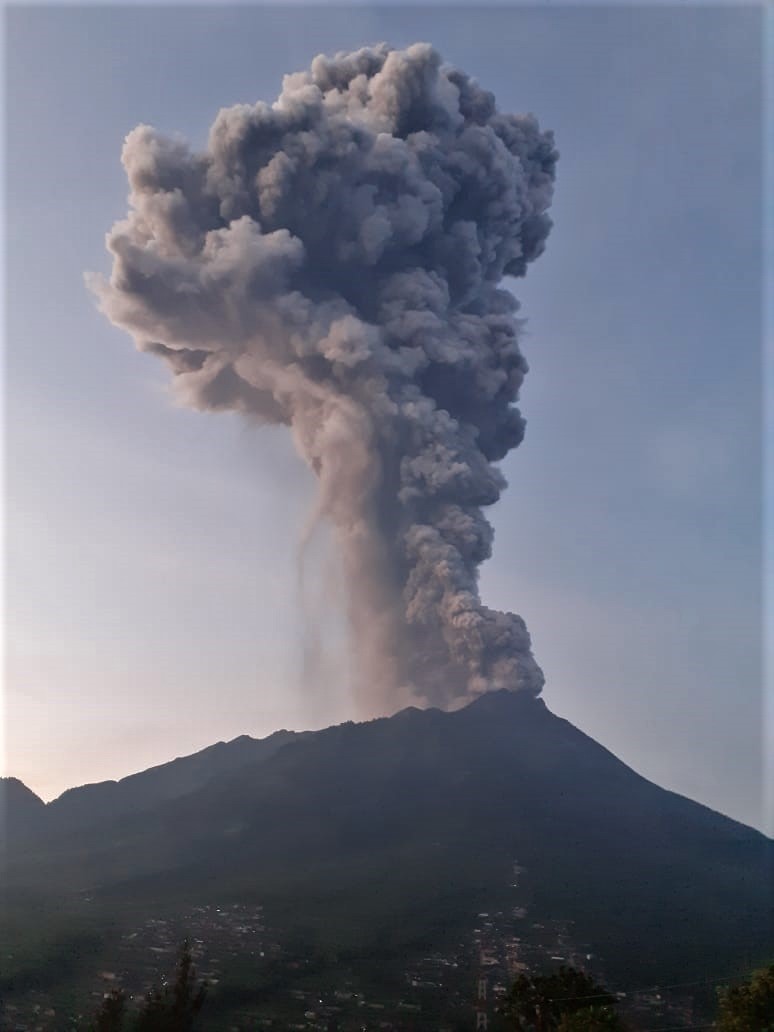
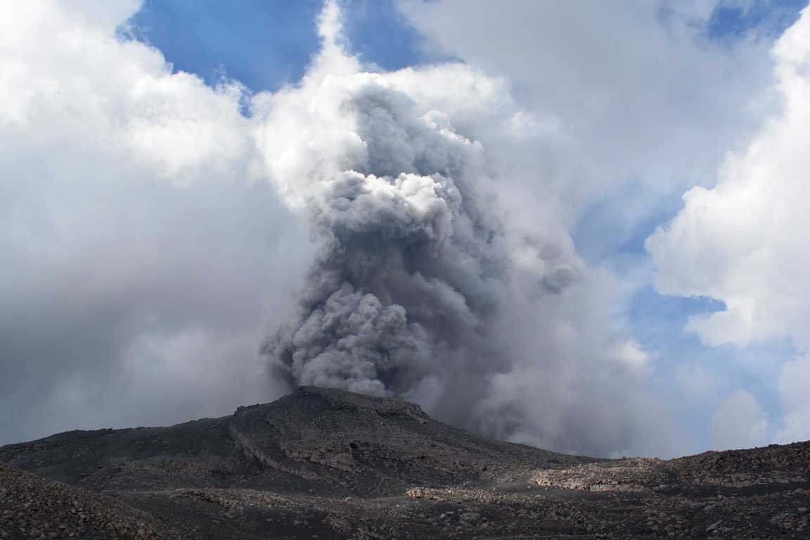
Eruption with volcanic ash cloud at 22h22 UTC (05h22 local). The eruption lasted for 450 seconds
Volcanic Cloud Height:
Best estimate of ash-cloud top is around 28698 FT (8968 M) above sea level, may be higher than what can be observed clearly. Source of height data: ground observer.
Other Volcanic Cloud Information:
Ash-cloud moving to north.
Remarks:
Eruption recorded on the seismogram with amplitude max 75 mm and 450 second duration.
Chronological press release of the Merapi volcano eruption on March 3, 2020
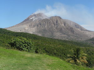
19 days after the eruption of February 13, 2020, today on March 3, 2020 at 5:22 am, there was an eruption with a column height of 6 km. The eruption was recorded on a seismograph with an amplitude of 75 mm and a duration of 450 seconds. Hot avalanches were observed up to <2 km in the South-South-East sector. A VONA message (Volcano Observatory Notice for Aviation) is published with a red color code. The wind during the eruption was oriented to the northeast. Ash rains occur within a 10 km radius of the summit, particularly in the northern sector, such as in the Musuk and Cepogo Boyolali sub-districts. Rains of ash mixed with sand were reported in the village of Mriyan, Boyolali, about 3 km from the summit of Mount Merapi.
As with previous eruptions, today’s eruption was not preceded by clear warning signs. The seismicity of March 2, 2020 consisted of an earthquake of VTA type, 8 event of MP type, 2 event of LF type and one event of DG 1 type. Similarly, the deformation did not show any changes either significant. These observational data indicate that as the eruption approached, there was not enough pressure to be identified because the eruption material was dominated by volcanic gas.
The series of eruptions from November 2019 to today and the VTA type seismic activity indicate that the Merapi volcano is currently in a phase of magmatic intrusion towards the surface. It is the 7th phase of eruption activity of Mount Merapi 2018-2020.
This type of eruption can always occur to indicate that the supply of magma to the magma chamber is still in progress. The threat of this eruption in the form of hot clouds coming from the collapse of the lava dome materials and projections of volcanic materials course over a range <3 km based on the volume of the dome of 396,000 m3 based on data from drone from November 19, 2019.
The communities must remain calm and do their activities as usual outside the 3 km radius around the summit of Mount Merapi.
Source : Magma Indonésie , Hanik Humaida/Responsable BPPTKG.
Peru , Sabancaya :
Analysis period: February 24 to March 1, 2020. Arequipa, March 2, 2020.
Alert level: ORANGE
The Peruvian Geophysical Institute (IGP) reports that the eruptive activity of the Sabancaya volcano has been maintained at moderate levels; that is to say with the continuous recording of moderate explosions and consequent emission of ash and gas. Consequently, for the following days, no significant change in activity is expected.
The IGP recorded and analyzed the occurrence of approximately 633 earthquakes of volcanic origin, associated with the circulation of fluids (magma, gas, etc.) inside the volcano. An average of 18 explosions per day of medium to low intensity were recorded.
The deformation of the volcanic structure does not record any significant anomalies. Visual surveillance made it possible to identify columns of gas and ash up to 2 km above the summit of the volcano, which were scattered in the western, southern and southwestern sectors of the Sabancaya. Satellite surveillance has identified the presence of a thermal anomaly worth 6 MW, associated with the presence of a body of lava on the surface of the volcano crater.
On February 26, 27 and 28 at 3:52 p.m., 2:20 p.m. and 1:00 p.m., respectively, the IGP recorded and reported the descent of 3 lahars (volcanic mud flow) by the Volcanes Peru mobile application in the Huayuray-Pinchollo gorges, in the northern sector of the Sabancaya volcano. The events presented volumes deemed low to moderate, which caused the temporary blockage of the Chivay-Cabanaconde road in the Cabanaconde district.
Source : IGP Peru .
Source : Auteur Inconnu .
United-States , Yellowstone :
44°25’48 » N 110°40’12 » W,
Summit Elevation 9203 ft (2805 m)
Current Volcano Alert Level: NORMAL
Current Aviation Color Code: GREEN
Recent work and news
Happy Birthday to Yellowstone National Park! On March 1, 1872,
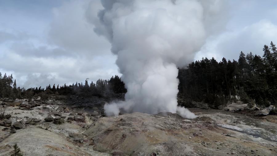
Steamboat geyser, in Norris Geyser Basin, experienced four water eruptions in the past month, on February 1, 12, 21, and 28, bringing the total number of eruptions for the year to 6.
Seismicity
During February 2020, the University of Utah Seismograph Stations, responsible for the operation and analysis of the Yellowstone Seismic Network, located 222 earthquakes in the Yellowstone National Park region. The largest event was a minor earthquake of magnitude 2.4 located 2.5 miles northeast of Lake, in Yellowstone National Park, on February 10 at 6:14 AM MST.
The monthly seismicity in Yellowstone included three earthquake swarms:
1) The largest earthquake swarm occurred about 16 miles east-northeast of West Yellowstone, MT, during February 17–24 (MST) and included 68 earthquakes ranging in magnitude from -0.4 to 2.1. The largest swarm event was a minor earthquake of magnitude 2.1 on February 20 at 05:14 AM MST.
2) A swarm of 38 earthquakes ranging in magnitude from 0.6 to 2.3 occurred about 15 miles south-southeast of Old Faithful, in Yellowstone National Park, during February 11–12 (MST). The largest swarm event was a minor earthquake of 2.3 on February 11 at 10:15 PM MST.
3) A small swarm of 13 events ranging in magnitude from -0.1 to 1.2 occurred about 10 miles north-northeast of West Yellowstone, MT, during February 3–4. The largest swarm event was a micro earthquake of 1.2 on February 4 at 00:09 AM MST.
Earthquake sequences like these are common and account for roughly 50% of the total seismicity in the Yellowstone region.
Yellowstone earthquake activity remains at background levels.
Ground deformation
Subsidence of Yellowstone caldera continues and has been ongoing since 2015 at an average rate of 2-3 cm (about 1 in) per year with minor fluctuations related to seasonal changes. In the area of Norris Geyser Basin, GPS data indicated the start of subsidence in September 2019, accumulating about 3 cm (a little over 1 in) of subsidence up to the end of the year. That subsidence appears to have paused as of early 2020, and no significant changes at Norris have been recorded since the start of the year.
Source : YVO.
Photo : Behnaz Hosseini. (Steamboat geyser).
Chile , Nevados de Chillan :
Special volcanic activity report (REAV), region of the Nevados de Chillán volcanic complex, on March 2, 2020 at 1:45 p.m. local time (mainland Chile).
The National Geological and Mining Service of Chile (Sernageomin) discloses the following PRELIMINARY information, obtained thanks to the surveillance equipment of the National Volcanic Surveillance Network (RNVV), processed and analyzed at the South Andes Volcanological Observatory (OVDAS ):
On Monday March 2, 2020 at 1:27 p.m. local time (4:27 p.m. UTC), the monitoring stations installed near the Nevados de Chillán volcanic complex recorded a volcano-tectonic earthquake, associated with rock fracturing, located 1.7 km east of the Nicanor crater.
The characteristics of the earthquake are as follows:
TIME OF ORIGIN: 1:27 p.m. local time (4:27 p.m. UTC).
LATITUDE: 36 867 ° S
LONGITUDE: 71.359 ° W
DEPTH: 3.5 km
LOCAL MAGNITUDE: 3.4 (ML)
OBSERVATIONS:
Following the occurrence of the earthquake, no surface changes were recorded.
The volcanic technical alert is maintained at the ORANGE level.
Source : Sernageomin .
Photo : Radio universidad de chile.
Kamchatka , Klyuchevskoy :
VOLCANO OBSERVATORY NOTICE FOR AVIATION (VONA).
Issued: 20200302/0411Z
Volcano: Klyuchevskoy (CAVW #300260)
Current aviation colour code: ORANGE
Previous aviation colour code: orange
Source: KVERT
Notice Number: 2020-28
Volcano Location: N 56 deg 3 min E 160 deg 38 min
Area: Kamchatka, Russia
Summit Elevation: 15580 ft (4750 m)

Volcanic Activity Summary:
A moderate explosive eruption of the Strombolian type of the volcano continues. According to videodata, a strong gas-steam activity of the volcano is observing all day. A some amount of ash into the gas-steam plume began to noting from 03:30 UTC this day. A gas-steam plume with some amount of ash is extending to the west of the volcano.
A moderate explosive eruption of the volcano continues. Ash explosions up to 16,400-23,000 ft (5-7 km) a.s.l. could occur at any time. Ongoing activity could affect low-flying aircraft.
Volcanic cloud height:
18040-19680 ft (5500-6000 m) AMSL Time and method of ash plume/cloud height determination: 20200302/0410Z – Video data
Other volcanic cloud information:
Distance of ash plume/cloud of the volcano: 9 mi (15 km)
Direction of drift of ash plume/cloud of the volcano: W
Time and method of ash plume/cloud determination: 20200302/0410Z – Video data
Source : Kvert .
Photo : Yu. Demyanchuk, IVS FEB RAS, KVERT