June 17 , 2019.
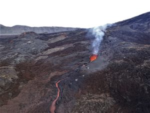
Philippines , Taal :
TAAL VOLCANO BULLETIN 17 June 2019 8:00 A.M.
Taal Volcano’s seismic monitoring network recorded eleven (11) volcanic earthquakes during the 24-hour observation period. Field measurements on 13 June 2019 at the western sector of the Main Crater Lake yielded an increase in water temperature from 32.5°C to 33.8°C, a decrease in water level from 0.15 meter to 0.11 meter and a decrease in acidity from a pH of 2.70 to 2.80. Ground deformation measurements through precise leveling surveys from 18 – 27 March 2019 indicated slight inflation of the edifice consistent with recent results from continuous GPS data.
Alert Level 1 remains in effect over Taal Volcano. This means that hazardous eruption is not imminent. The public, however, is reminded that the Main Crater should be strictly off-limits because sudden steam explosions may occur and high concentrations of toxic gases may accumulate. The northern portion of the Main Crater rim, in the vicinity of Daang Kastila Trail, may also become hazardous when steam emission along existing fissures suddenly increases. Furthermore, the public is also reminded that the entire Volcano Island is a Permanent Danger Zone (PDZ), and permanent settlement in the island is strongly not recommended.
Source : Phivolcs.
Photo : Topexpos Voyages
El Salvador , San Miguel ( Chaparrastique ) :
Location: San Miguel Department
Altitude: 2130 meters.
Type of volcano: Stratovolcano
Activity type: Strombolian – Vulcanian
Last major eruption: December 29, 2013.
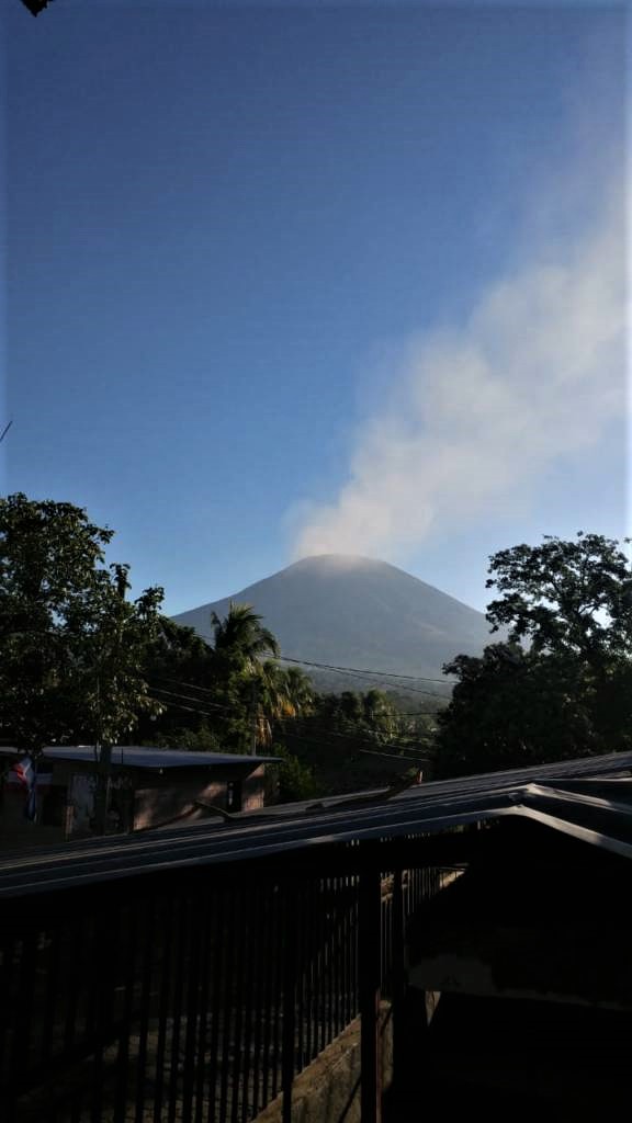
In May, the seismic vibrations of the San Miguel volcano remained low, fluctuating between 37 and 83 RSAM units on average per day. Only two (2) microseisms of magnitude (Ml <1) were located on the northern flank of the volcano a few meters deep. No earthquakes were perceived by the population living in the area.
For sulfur dioxide (SO2) emissions, they fluctuated between 22 and 331 tonnes per day, averaging 142 t, with a threshold of 620 t / d. Monitoring data indicate that the activity of the volcano has remained low, but it is not excluded that it suddenly changes. It is therefore suggested to mountaineers and the general population to avoid visiting the crater.
Source : Marn.
Photo : Jorge Rivas
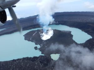
Ecuador , Reventador :
DAILY REPORT OF THE STATE OF THE VOLCANO REVENTADOR N ° 2019-167, SUNDAY JUNE 16, 2019, Information: Geophysical Institute – EPN
Level of surface activity: high
Superficial trend: no change
Internal activity level: high
Internal trend: no change
Seismicity:
From 15 June 2019, 11:00 until 16 June 2019, 11:00
Long period type events (LP): 24
Explosions (EXP): 17
Tremor of emission (TE): 14
Harmonic tremor (TA): 4
Gas flow (SO2) (ton / day): 278.0 +/- 79.0 Number of measures validated: 4.
Rain / lahars:
Moderate rains were recorded during the night.
Emission / column of ash: At night, between the clouds, small emissions of 300 meters were observed at the summit facing west.
Other monitoring parameters: No change.
Observations: Most of the volcano remained under cloud, however, during the night, incandescence was observed in the upper part and blocks rolled up to 800 meters under cloud cover, mainly on the north-east flank. .
Alert level: orange
Source : IGEPN
Photo : auteur inconnu.
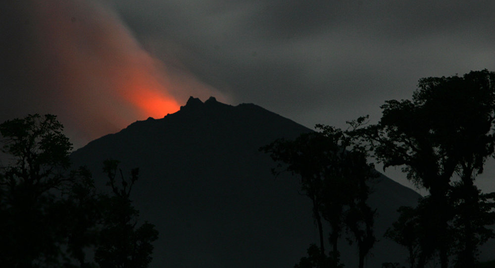
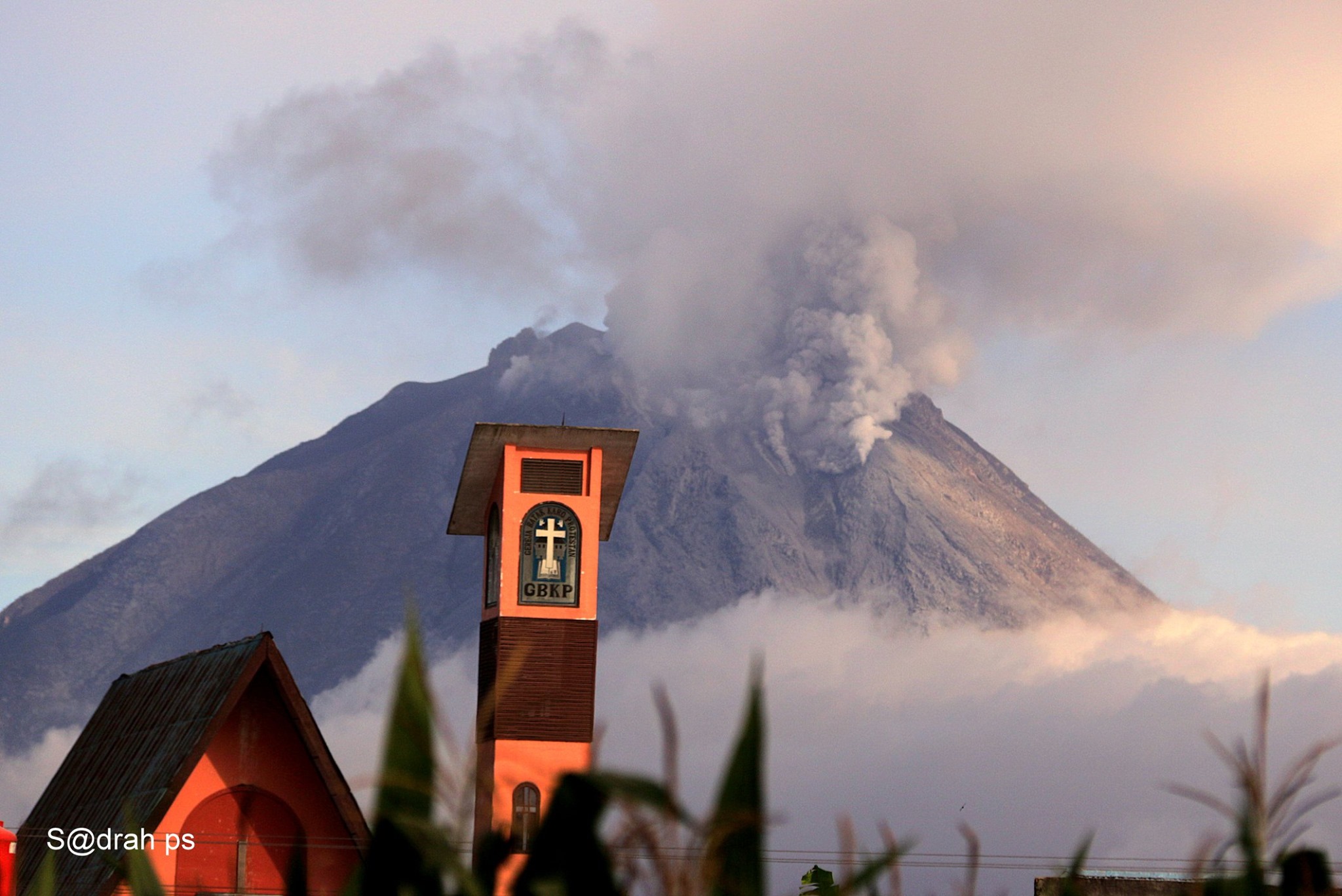
Indonesia , Sinabung :
The level of activity since May 20, 2019 at 10:00 am is set at Level III (SIAGA). Mount Sinabung (2,460 m above sea level) has been erupting since 2013. The last eruption occurred on June 9, 2019.
From yesterday to this morning, Mount Sinabung was clearly visible until it was covered with fog. The smoke from the main crater was white, thin to thick, rising 200 meters above the summit.
Through seismographs, 16 June 2019, it was recorded:
7 earthquakes of explosions
1 volcanic earthquake
1 Tornilo earthquake
2 local tectonic earthquakes
3 distant tectonic earthquakes.
Recommendation:
The community and visitors must not carry out activities in the evacuated villages, nor in the localities located within a radius of 3 km around the summit of Mount Sinabung, and within a sectoral radius of 5 km for the South-East sector and 4 km for the North-East sector.
In the event of ash rains, residents are encouraged to wear masks, secure drinking water facilities and clean the roofs of dense volcanic ash houses to prevent them from collapsing.
Communities along the river below Mount Sinabung should be aware of the potential of lahars, especially during heavy rains.
VONA: The latest ORANGE color code was issued on June 10, 2019 at 14:21 WIB, and related to gas emissions with a smoke column height of 2,960 meters above sea level or approximately 500 m above the summit. The smoke column was moving east-southeast.
Source : PVMBG
Photo : 07 Mai 2019 , Sadrah Peranginangin