December 23 , 2021 .
La Réunion , Piton de la Fournaise :
Press release of December 23, 2021 – 12:00 p.m.
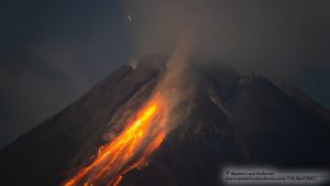
The eruption that began on December 22, 2021 at around 3:30 a.m. local time continues. With the decrease of the first lava fountains, the amplitude of the eruptive tremor (indicator of an emission of lava on the surface) decreased sharply during the day yesterday, and has stabilized today at around 30% of its initial amplitude. A few superficial earthquakes, and of Magnitude <0.5, are still detected directly above the summit, and two earthquakes were located under the eastern flank of the volcano about 0.6 km below sea level.
Over the last 24 hours:
– The surface deformations do not show any particular displacement.
– Thanks to milder weather, estimates of lava flow were established by satellite method with the HOTVOLC platform (OPGC – Clermont Auvergne University), with an average of 4-7 m3 / sec and peaks at 22 m3 / sec.
Since last night, activity has only focused on one of the eruptive cracks, the one further downstream (around 2030 m altitude), where a cone began to form.

A field reconnaissance was made this morning thanks to the assistance of the Air Section of the Gendarmerie and the PGHM. This mission made it possible to precisely locate the vent which is still active and the flow front. Around 9:30 a.m. (local time):
– the lava flow, in graton, had traveled 2.2 km from its point of emission (and was located at approximately 2000 m altitude)
– the casting front was located at:
. 550 m from the southern rampart
. 3.2 km from the top of the big slopes
. 8.1 km from the road
. 9 km from the ocean.
This mission also made it possible to recover samples of lava (slag projected by lava fountains and lava flows) which will be very useful, once analyzed, to better understand the path taken by the deep magma and the dynamism of the eruption. At 9:30 a.m. local time, the lava fountain regime was still very active but with heights only intermittently exceeding the height of the cone, estimated at 10 m.
Niveau d’alerte : Alerte 2-1 (éruption dans l’Enclos)
Source et photos : OVPF.
Italy , Stromboli :
WEEKLY NEWSLETTER, from December 13, 2021 to December 19, 2021 (issue date December 21, 2021)
SUMMARY OF ACTIVITY STATUS
In view of the monitoring data, it is highlighted:
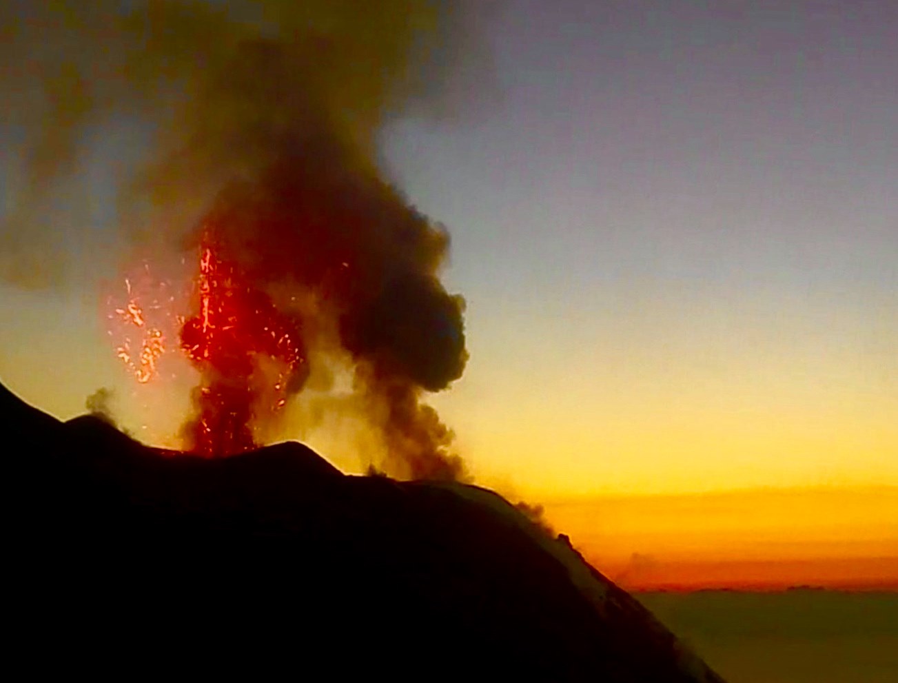
1) VOLCANOLOGICAL OBSERVATIONS: During this period, a normal explosive activity of Strombolian type was observed with splashing activity in zone N. The total hourly frequency of the explosions fluctuated between medium and high values (11-25 events / h ). The intensity of the explosions varied from low to medium both in the area of the North crater and in the area of the Center-South crater.
2) SEISMOLOGY: The seismological parameters monitored do not show significant variations.
3) SOIL DEFORMATION: The island’s soil deformation monitoring networks did not show any significant changes to report for the period under review.
4) GEOCHEMISTRY: The flow of SO2 is at an average level The flow of CO2 from the soils in the summit area shows a slight increase towards a level between high and very high.
The C / S value in the updated and validated plume in the plume is 7.23, settling to medium-high values.
There are no significant changes in isotope ratios compared to the previous sampling (November 15, 2021), settling on high values with an R / Ra of 4.41.
5) SATELLITE OBSERVATIONS: After the effusive event of November 26, the thermal activity observed by satellite showed low level anomalies.
VOLCANOLOGICAL OBSERVATIONS
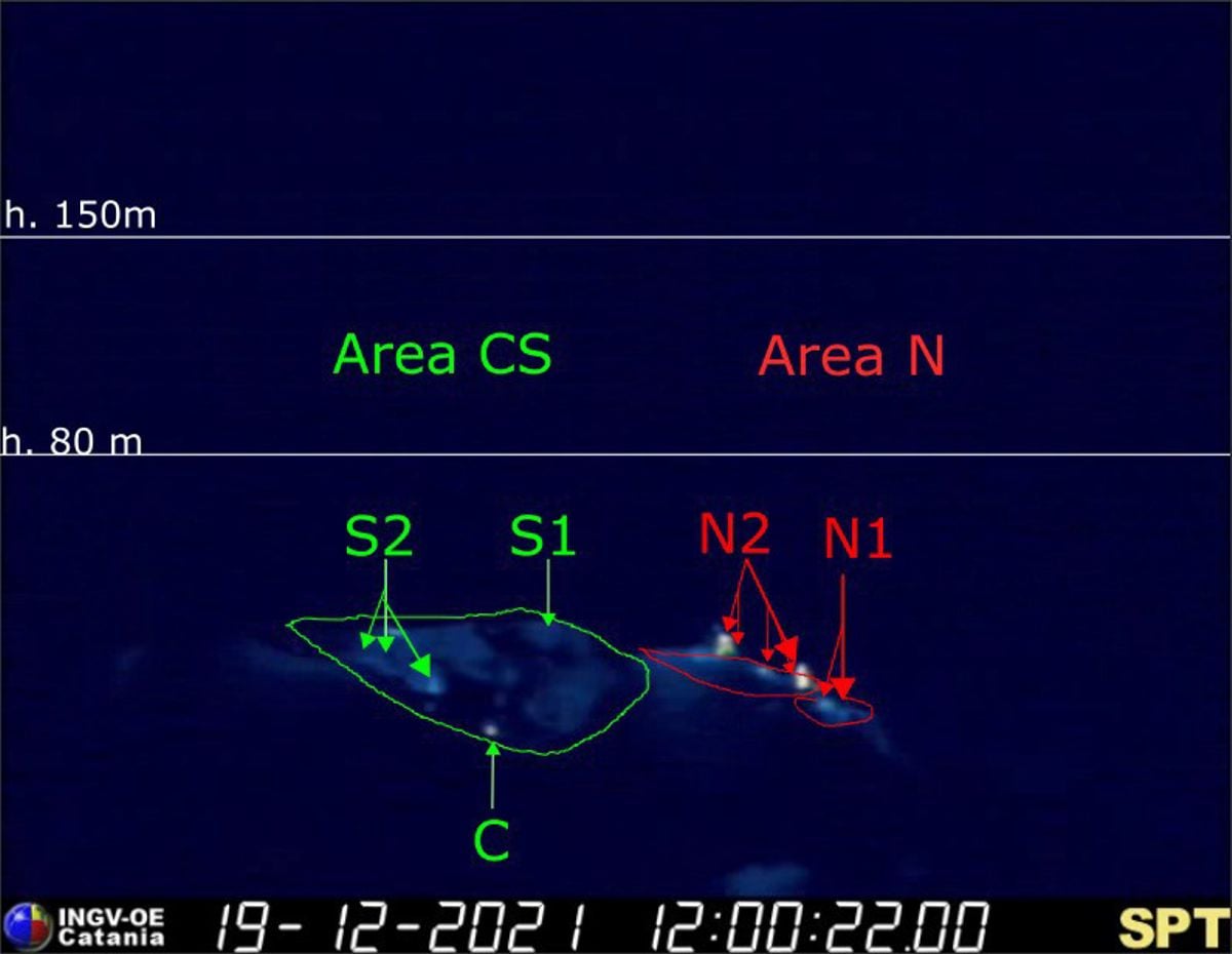
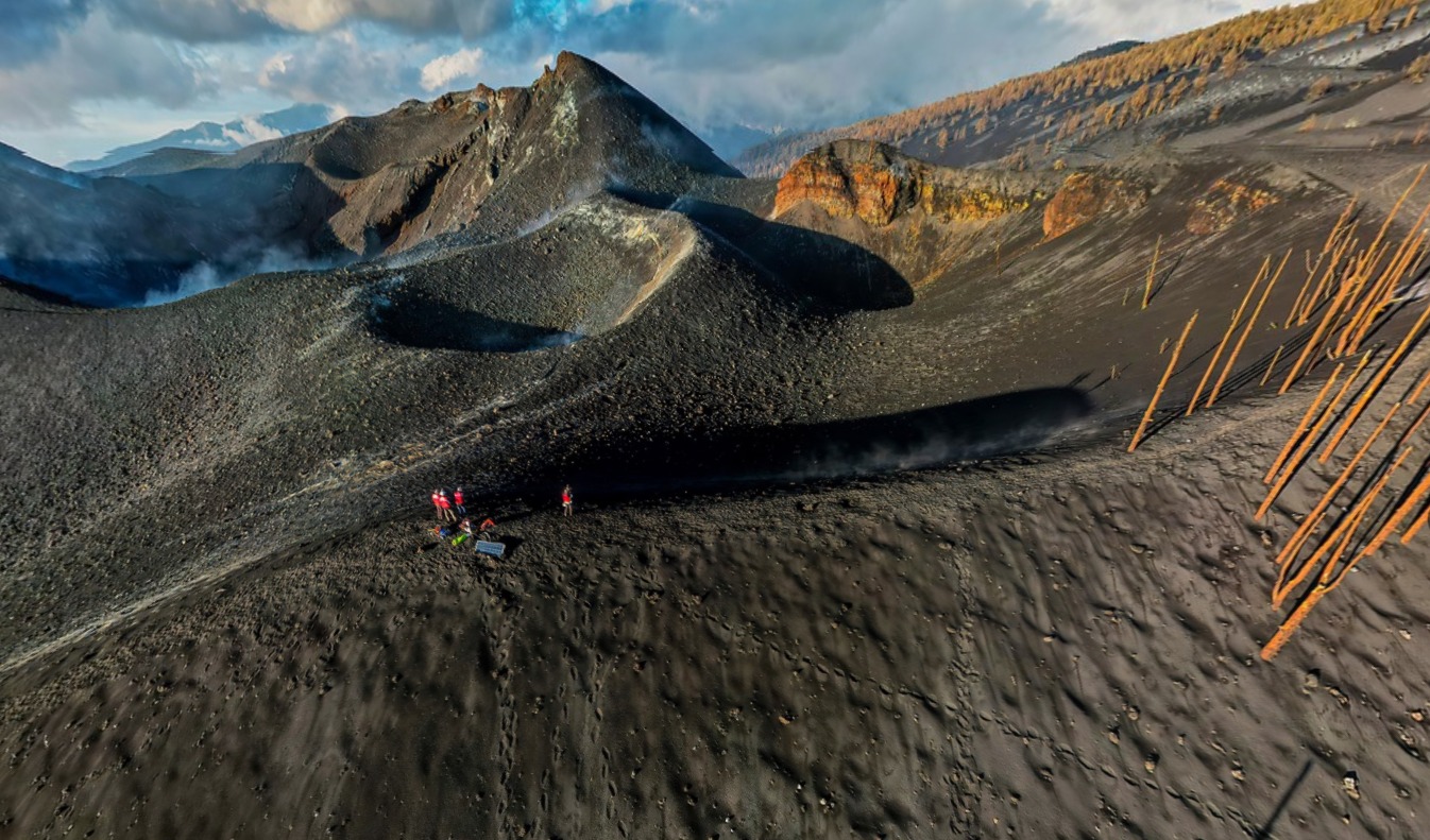
During the observation period, the eruptive activity of Stromboli was characterized by the analysis of the images recorded by the surveillance cameras of the INGV-OE (altitude 190m, Punta Corvi, altitude 400m and Pizzo). The explosive activity was mainly produced by 7 (seven) eruptive chimneys located in the North crater area and 4 (four) eruptive chimneys located in the Center-South crater area. All the vents are placed inside the depression which occupies the terrace of the crater (Fig. 3.1).
Description of eruptive activity recorded by surveillance cameras.
Sector N1, with two emission points, located in the area of the North crater produced explosions of mainly medium-low intensity (sometimes the products of the explosions exceeded 80 m in height) emitting coarse materials (lapilli and bombs) . Sector N2, with five emission points, showed an explosive activity of medium-low intensity (sometimes the products of the explosions exceeded 80 m in height) emitting coarse materials with a projection activity which was intense until December 16. . The average frequency of explosions varied from 8 to 18 events / h.
In the Center-South zone, sector S1 did not show significant explosive activity, while the three vents located in sector S2 produced explosions, sometimes at the same time, of mainly medium-low intensity (sometimes the products of the explosions exceeded 80 m in height) emitting fine matter (ash) mixed with coarse matter. Sector C exhibited modest explosions of gas and coarse materials.
The frequency of the explosions varied from 2 to 7 events / h.

Description of eruptive activity following inspections in the summit area.
In the North zone, the N1 crater was characterized by the presence of an active vent with explosions emitting coarse and ashless materials, the frequency of which was variable between 3 and 1 explosions / hour, respectively for December 15 and 16.
The N2 crater area was characterized by one active vent on December 15 and seven different vents the next day. On the 15th, during the observation period, the activity was localized exclusively at the level of a cone built on the north-western edge of the N2 zone towards the Sciara del Fuoco and was characterized by continuous puffs and splashing, with episodes of significant intensity lasting more than a minute. The explosions were characterized by the emission of coarse, ashless materials, with a frequency of 10 explosions / hour. On December 16, the splash activity had moved to a vent at the base of a cone inactive the day before and located on the northeast edge of the N2 area towards the Sciara del Fuoco. The material that accumulated near the eruptive vent with the splash activity determined the rapid growth of the cone. On the 16th, in sector N2, 5 other vents were active, all incandescent, of which three, sometimes four, produced simultaneous explosive activity with an explosive frequency of 6 events / hour. Only one of these mouths produced a modest amount of ash.
During the observation period, the plume prevented detailed observation of the Center-South zone in which, on the 15th, there was an incandescent vent in the easternmost sector of the CS1 crater zone.
The explosive activity was 2 and 1 events / hour, respectively for December 15 and 16 and was characterized by the emission of remodeled ash produced by one or more vents located in the southern sector of CS1.
Source : INGV.
Photos : INGV , webcam.
Spain / La Palma , Cumbre Vieja :
December 22, 2021 09:00 UTC. Volcanic monitoring continues on La Palma.
Since the last declaration, 19 earthquakes have been located on the island of La Palma, none of them have been felt by the population. The magnitudes vary between 1.4 and 3.0 (mbLg). The localization of hypocenters continues under the central area of Cumbre Vieja in the same areas as the previous days. 16 earthquakes were located at depths between 9 and 15 km and 3 earthquakes at depths less than 5 km. During this period, no earthquake was located at a depth greater than 15 km.
There is still no volcanic tremor observed, the seismic noise remains at levels close to the pre-eruptive period.
The island’s network of permanent GNSS stations shows that the elevation at station LP03, which is closest to the eruptive centers, remains at the level it reached on December 19. In the rest of the stations, no significant deformation is observed which could be associated with volcanic activity.
In view of the image calibrated at 08:45 UTC, no type of emission is visible.
The height of the cone is measured by obtaining a value of 1122 m at sea level.
Sources : IGNes , El Pais .
Photo : I love the world .
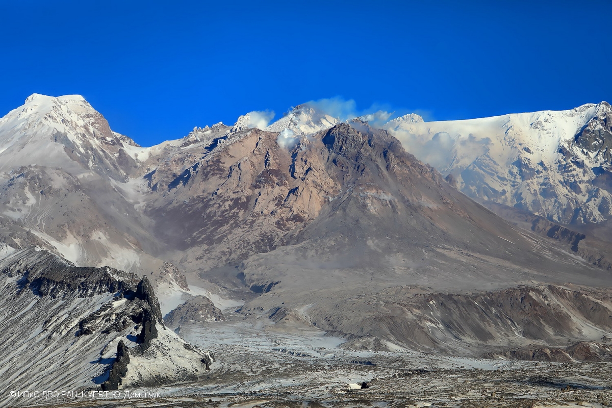
Kamchatka , Sheveluch :
VOLCANO OBSERVATORY NOTICE FOR AVIATION (VONA)
Issued: December 23 , 20211223/0117Z
Volcano: Sheveluch (CAVW #300270)
Current aviation colour code: ORANGE
Previous aviation colour code: orange
Source: KVERT
Notice Number: 2021-155
Volcano Location: N 56 deg 38 min E 161 deg 18 min
Area: Kamchatka, Russia
Summit Elevation: 3283 m (10768.24 ft), the dome elevation ~2500 m (8200 ft)
Volcanic Activity Summary:
A growth of the lava dome continues, a strong fumarolic activity, and an incandescence of the lava dome and hot avalanches accompanies this process. Satellite data by KVERT showed explosions sent ash up to 5.7-6.0 km a.s.l. and ash plume extended for 31 km to the northeast of the volcano.
The extrusive eruption of the volcano continues. Ash explosions up to 10-15 km (32,800-49,200 ft) a.s.l. could occur at any time. Ongoing activity could affect international and low-flying aircraft.
Volcanic cloud height:
5700-6000 m (18696-19680 ft) AMSL Time and method of ash plume/cloud height determination: 20211223/0010Z – Himawari-8
Other volcanic cloud information:
Distance of ash plume/cloud of the volcano: 31 km (19 mi)
Direction of drift of ash plume/cloud of the volcano: NE / azimuth 51 deg
Time and method of ash plume/cloud determination: 20211223/0040Z – Himawari-8
Start time of explosion and how determined: December 23 , 2021 – Satellite data
Source : Kvert
Photo : Yu. Demyanchuk, IVS FEB RAS, KVERT
Colombia , Nevado del Ruiz :
Bulletin of the activity level of the Nevado del Ruiz volcano.
The activity level continues at: Yellow activity level or (III): changes in the behavior of volcanic activity.
Regarding the monitoring of the activity of the Nevado del Ruiz volcano, the SERVICIO GEOLÓGICO COLOMBIANO reports that:
The seismicity linked to the dynamics of the fluids inside the volcanic conduits has increased in the number of recorded earthquakes and in the seismic energy released compared to the previous week. This seismic activity was characterized by the appearance of continuous volcanic tremor, tremor pulses, long and very long period earthquakes, which exhibited moderate energy levels and variable spectral content. These earthquakes were located mainly in the Arenas crater. Some of these signals were associated with ash emissions, confirmed by cameras installed in the area of the volcano and by the report of officials of the Colombian Geological Service and Los Nevados National Natural Park.
The seismicity generated by the fracturing of the rock maintained similar levels in the number of earthquakes and in the seismic energy released compared to the previous week. This seismic activity was located mainly in the distal South-South-West, North-East and North-North-West sectors of the volcano, in the Arenas crater and its surroundings and, to a lesser extent, in the South-East sector. The depths of the earthquakes ranged from 0.5 to 7.0 km. The seismic increase recorded today stands out, about 5.0 km northwest of the Arenas crater. The maximum magnitude recorded during the increase and this week was 1.7 ML (Local Magnitude) corresponding to the earthquake recorded on December 21 at 1:00 p.m. (local time), located 5.2 km north-northwest of the crater Arenas, 6.5 km deep.
Source : SGC.
Photo : Diana M Bustamante.
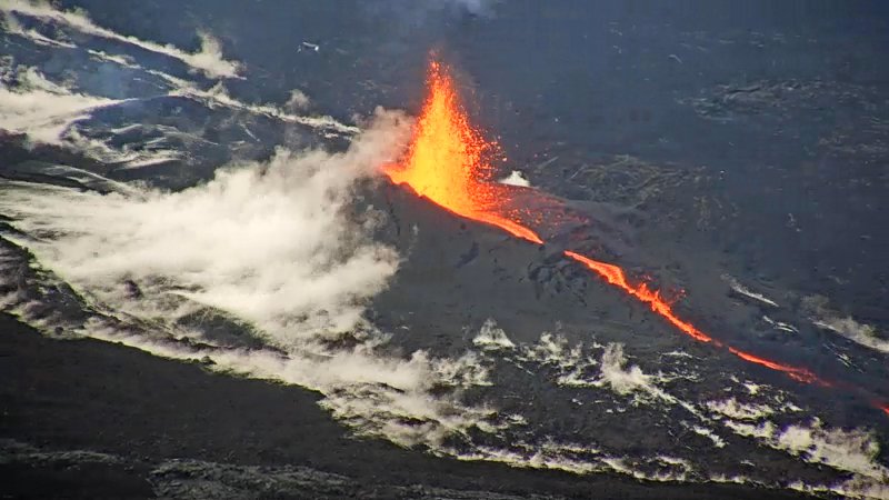
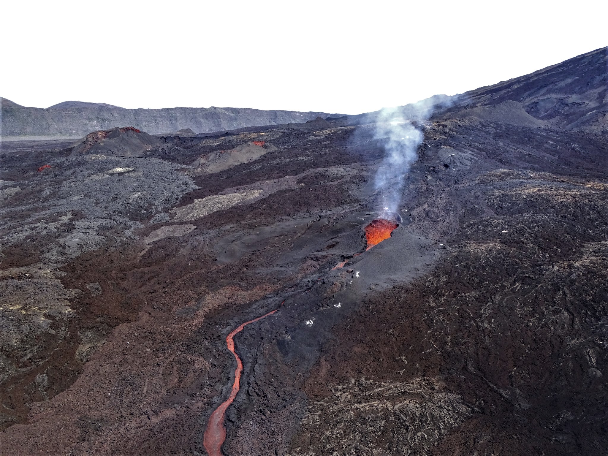
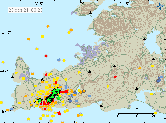
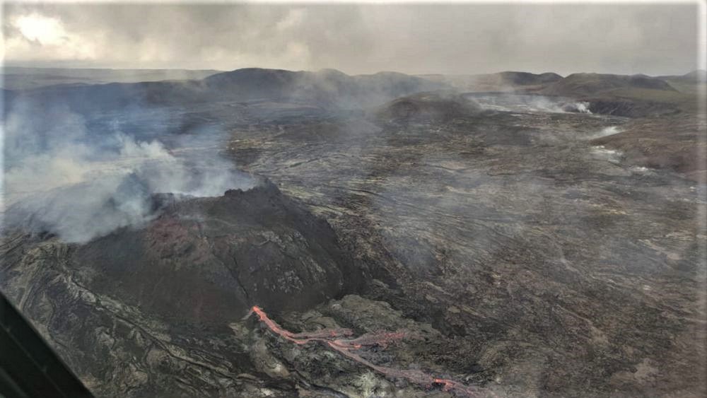
Iceland , Geldingadalur :
Update on the eruption in Geldingadalur
Intense seismic swarm started , 22.12.2021
No new lava flows have been detected at the crader in Fagradalsfjall for the past three months. Uplift is still ongoing in the area and the scientists are currently working on modelling the ongoing processes and identifying the possible scenarios.
„It can be difficult to say with some accuracy when an eruption is finished, because the volcanic activity can be intermittent“ says Sara Barsotti coordinator for Volcanic Hazards at IMO. „Before the eruptive activity in Geldingadalir started, the Reykjanes peninsula has been very active in terms of seismic activity and magmatic unrest. As we know from the past, when the peninsula is reactivated, episodic eruptions might occur as a series“ says Sara.

Three months has gone since no new lava was produced from the main crader in Geldingadalir, so the eruption that started on the 19th of March lasted for about six months and can be considered closed. Deformation data show that there is still magma inflow in the crust by Fagradalsfjall so it is difficult to predict how the situation will evolve. „ We continue to monitor the Reykjanes peninsula closely but we can say that the specific eruption that started on the 19th of March got to an end. However, even though this episode is closed, we know the activity in the area is still ongoing and other eruptive phases might start in the near future“ says Sara.
IMO is monitoring the area closely and at 18:00UTC last night (21. Dec) a seismic swarm started 2-4 km NE of Geldingadalir. The activity then increased around 00:30UTC and it is still very active with 1-10 earthquakes per minute. Later in the night the activity shifted closer to the volcano in Geldingardalir. This activity can be explained as magma intruding in the crust. There are currently no indication of volcanic tremor in the area.
Up to this point this seismic swarm counted around1.400 automatically detected earthquakes and 90 of these are larger than M2. The largest earthquake was M4,9 and occurred at 09:23UTC at about 2 km SW of Geldingadalir.
Due to the elevated seismic activity the aviation color code has been raised from yellow to orange.
Source : Vedur is.
Photo : Matthias Vogt – Volcano Heli