December 24 , 2021.
Tonga Islands , Hunga Tonga-Hunga Ha’apai :
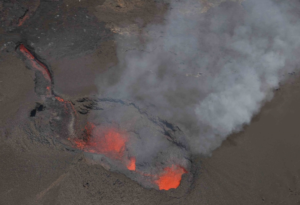
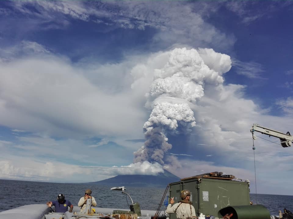
An explosive volcanic eruption shooting ash and pyroclastic material up to 350 metres above sea level was captured on camera yesterday by a Tonga Navy crew, sailing close to the Hunga Tonga-Hunga Ha’apai active volcano.
Taaniela Kula, leading the Tonga Geological Service volcano monitoring, said the important video, uploaded to Instagram by a crew member late yesterday, helped Tongan geologists understand the nature of the explosive basal surge eruption.
The Ministry of Lands & Natural Resources has been relying on satellite imagery analysis, since an explosive ash eruption at Hunga Ha’apai on Monday sent ash and dust 18km above sea level, followed by clouds of gaseous emissions over following days.
Taaniela said while the ash rose and fell down, the steam vapor went higher and travelled further across Tonga.
“These pyroclastic explosives fired up to only 350m tops and fell back down. Only the gaseous materials plumed all the way up to 8-14km altitude.”
According to a news article, Tonga’s head geologist reported that an eruption at Hunga Tonga-Hunga Ha’apai began at 0935 on 20 December. The eruption produced a steam-rich gas-and-ash plume that initially rose to 6 km (19,700 ft) a.s.l. by 0940, and then continued to ascend to 16 km (52,500 ft) a.s.l. and drift N. Lightning was present in the plume and about 9 kilotons of sulfur dioxide was detected in satellite data. Residents of Vava’u, 270 km NE, heard a series of explosions at a rate of several times per minute for the first 1-2 hours, after which they became sporadic. Explosions were heard through the night within the first 12 hours of the eruption. Ash emissions ceased at around 0200 on 21 December, though intermittent gas plumes with lightning continued at least through that day. Based on pilot observations, the Wellington VAAC noted that plumes rose 6.1-12.2 km (20,000-40,000 ft) a.s.l. and drifted N and NE on 21 December.
Sources : Matangitonga.to , GVP .
Photos : Shane Egan.
Video : Matangitonga.to.
La Réunion , Piton de la Fournaise :
Press release of 12/24/2021 – 12:00 p.m.
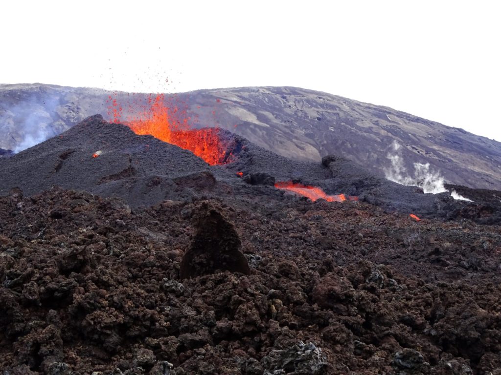
The eruption that began on 12/22/2021 at around 3:30 a.m. local time continues. Following the decrease of the first lava fountains, the amplitude of the eruptive tremor (indicator of a lava emission on the surface) stabilized during the day yesterday, at about 30% of its initial amplitude.
Over the last 24 hours:
– A single superficial earthquake, and of low magnitude (<0.5), was recorded directly above the summit.
– The surface deformations do not show any particular displacement.
– The improvement in meteorological conditions made it possible to obtain several estimates of lava flow by satellite method with the HOTVOLC platform (OPGC – Clermont Auvergne University). These estimates over the past 24 hours averaged between 4 and 10 m3 / sec and a peak was recorded this morning at 20 m3 / sec.
An overview was made this morning by the Volcanological Observatory. This mission made it possible to precisely locate the flow front. Around 9:00 a.m. (local time):
– the lava flow, had traveled 2.4 km from its point of emission (and was located at an altitude of approximately 2000 m.
– the flow front was located 540 m from the southern rampart, about 2 km from the top of the major slopes, about 8 km from the road, and about 9 km from the ocean.
Since the end of the first day of eruption, activity has focused only on one of the eruptive cracks, the one further downstream (around 2030 m altitude), where a cone has formed since then. yesterday.
Alert level: Alert 2-1 (eruption in the enclosure)
Source : management of the OVPF-IPGP
Photo : ovpf via fournaise info
Spain / La Palma , Cumbre Vieja :
December 23 , 2021 09:00 UTC Volcanic monitoring continues in La Palma.
Since the last declaration, 20 earthquakes have been located on the island of La Palma, none of them have been felt by the population. The magnitudes range from 1.3 to 2.7 (mbLg). The localization of hypocenters continues under the central area of Cumbre Vieja in the same areas as the previous days. 14 earthquakes were located at depths between 8 and 19 km, 4 earthquakes at depths less than 5 km and 2 at depths of about 35 km.
There is still no volcanic tremor observed, the seismic noise remains at levels close to the pre-eruptive period.
As yesterday, the island’s network of permanent GNSS stations shows that the elevation at station LP03, which is closest to the eruptive centers, remains at the level it reached on December 19. In the rest of the stations, there are no significant deformations that could be associated with volcanic activity.
No type of emission is appreciated, and the height of the cone is measured, obtaining a value of 1,122 m at sea level.
Technicians assured on Thursday that if signs of exhaustion from the Cumbre Vieja volcano continue « over the next two days », the eruptive process at La Palma can be said to be over. “Observations continue to corroborate the signs of exhaustion of the eruptive process. The end of the eruption does not necessarily mean the end of certain dangers associated with the volcanic phenomenon or the end of magmatic reactivation, ”said Carmen López, responsible for volcanic monitoring at the National Geographic Institute. López explained that the visible emissions of volcanic gases continue, but that they are point and sporadic and are concentrated in the area of the eruptive centers and in the fractures of the volcanic tubes. The tremor is at the level of the background noise and the seismicity is at very low levels at all depths, although it is not excluded that there may be felt earthquakes. On Wednesday, the level of good air quality was maintained in all seasons on the island.
Sources : IGNes , El Pais .
Photo : I love the world.
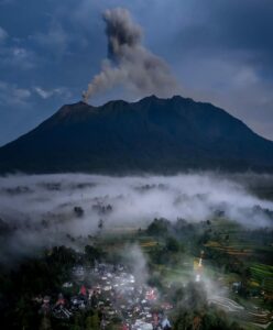
Papua /New Guinea , Manam :
The Darwin VAAC reported that a thermal anomaly over Manam was identified in satellite images on 15 December, prior to an ash emission that rose to 6.1 km (20,000 ft) a.s.l. and drifted SW. An ash plume rising to the same altitude was visible in satellite images on 16 December but had dissipated by mid-morning. Later that day diffuse ash plumes rising to 2.4 km (8,000 ft) a.s.l. were visible in satellite images and reported by ground observers, according to RVO. An eruptive event was recorded by the seismic network at 0600 on 17 December; ground observations indicated that an ash plume likely rose to 3 km (10,000 ft) a.s.l. and drifted SE. At 0840 ash emissions identified in satellite images and by observers rose to 3 km, drifted SE, and dissipated within about five hours. At 0220 on 18 December an ash plume rose to 3 km, drifted SE, and again dissipated within about five hours; a thermal anomaly over the summit was visible in the satellite data. At 1600 on 21 December an ash plume rose to 1.5 km (5,000 ft) a.s.l., drifted NE, and dissipated within about three hours. The thermal anomaly persisted.
The 10-km-wide island of Manam, lying 13 km off the northern coast of mainland Papua New Guinea, is one of the country’s most active volcanoes. Four large radial valleys extend from the unvegetated summit of the conical basaltic-andesitic stratovolcano to its lower flanks. These valleys channel lava flows and pyroclastic avalanches that have sometimes reached the coast. Five small satellitic centers are located near the island’s shoreline on the northern, southern, and western sides. Two summit craters are present; both are active, although most observed eruptions have originated from the southern crater, concentrating eruptive products during much of the past century into the SE valley. Frequent eruptions, typically of mild-to-moderate scale, have been recorded since 1616. Occasional larger eruptions have produced pyroclastic flows and lava flows that reached flat-lying coastal areas and entered the sea, sometimes impacting populated areas.
Source : GVP.
Photo : Jhay Mawengu ( archive 2018).
Indonesia , Semeru :
PVMBG reported that the eruption at Semeru continued during 14-21 December. Incandescent lava avalanches from the end of a 1.8-km-long lava flow in the Kobokan drainage on the SE flank descended 200-800 m during 14-15 December. Crater incandescence was visible overnight during 15-16 December and two incandescent avalanches traveled 500 m from the crater. On 16 December three pyroclastic flows, recorded at 0901, 0930, and 15h42, traveled a maximum of 4.5 km down the SE flank. At 23h00 PVMBG raised the Alert Level to 3 (on a scale of 1-4), noting increasing distances of pyroclastic flows and expanded the exclusion zone to a 5 km radius around the crater and 13 km in the SSE sector. The public was warned to stay at least 500 m away from Kobokan drainages within 17 km of the summit, and other drainages originating on Semeru including the Bang, Kembar, and Sat, due to lahar, avalanche, and pyroclastic flow hazards.
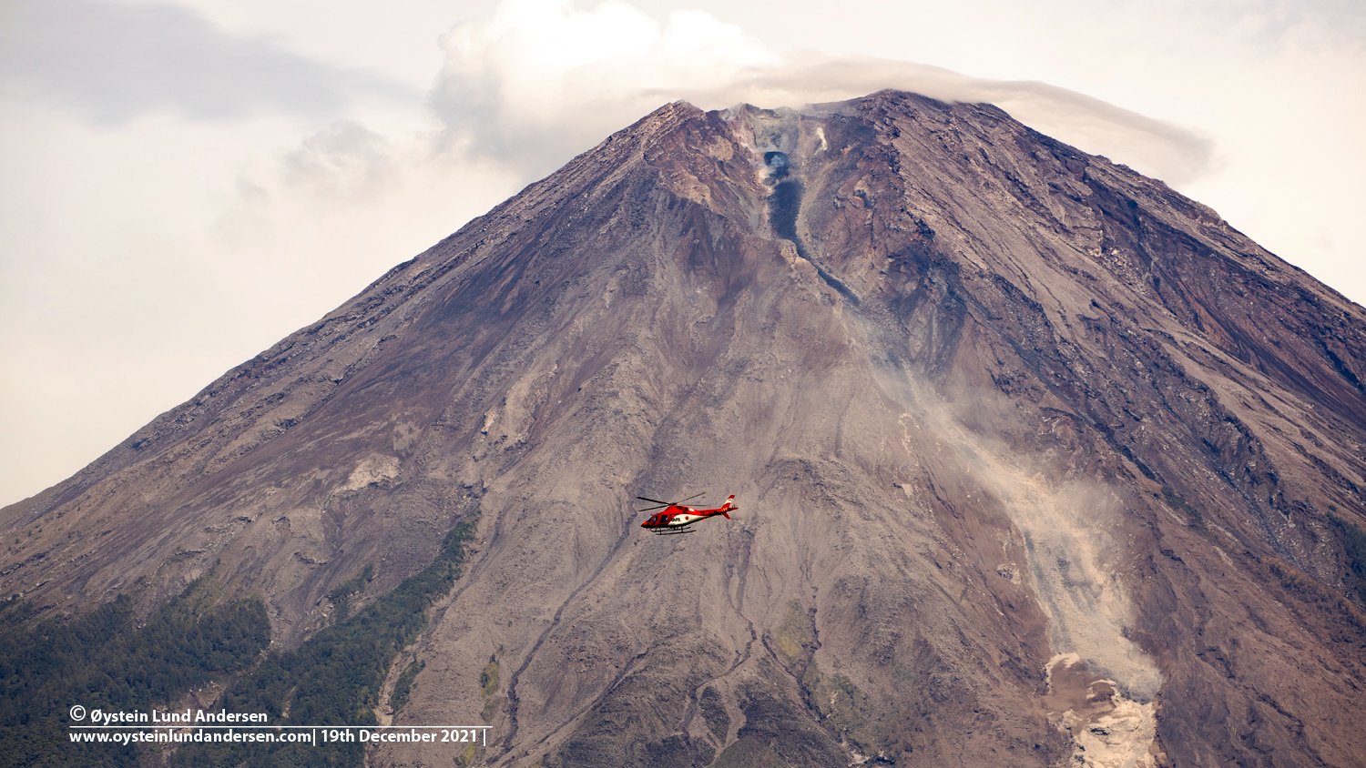
Two pyroclastic flows descended 500 m during 17-18 December and ash plumes rose 200 m and drifted SW. At 05h56 on 20 December an eruptive event produced an ash plume that rose 1.5 km above the crater rim. One pyroclastic flow traveled 3 km SE that day and another one the next day. The crater was incandescent overnight during 20-21 December when weather permitted visual observations. According to BNPB, 11,658 people were in 52 evacuation centers by 14 December.
VOLCANO OBSERVATORY NOTICE FOR AVIATION – VONA
Issued : December 22 , 2021
Volcano : Semeru (263300)
Current Aviation Colour Code : ORANGE
Previous Aviation Colour Code : orange
Source : Semeru Volcano Observatory
Notice Number : 2021SMR88
Volcano Location : S 08 deg 06 min 29 sec E 112 deg 55 min 12 sec
Area : East java, Indonesia
Summit Elevation : 11763 FT (3676 M)
Volcanic Activity Summary :
Pyroclastic flow occured from the edge of lava deposit at 15h11 UTC ( 22h11 local )
Volcanic Cloud Height :
Best estimate of ash-cloud top is around 12723 FT (3976 M) above sea level, may be higher than what can be observed clearly. Source of height data: ground observer.
Other Volcanic Cloud Information :
Ash-cloud moving to south-southwest
Remarks :
Lava flow is observed through the Southeast direction of the Semeru summit crater.
Sources : GVP , Magma Indonésie .
Photo et video : Oystein Lund Andersen.
MERRY CHRISTMAS