March 22, 2024. EN. Iceland : Reykjanes Peninsula , Colombia : Purace / Los Coconucos Volcanic Range , Indonesia : Semeru , Kamchatka : Sheveluch , Nicaragua : Massaya .

March 22 , 2024.


Iceland , Reykjanes Peninsula :

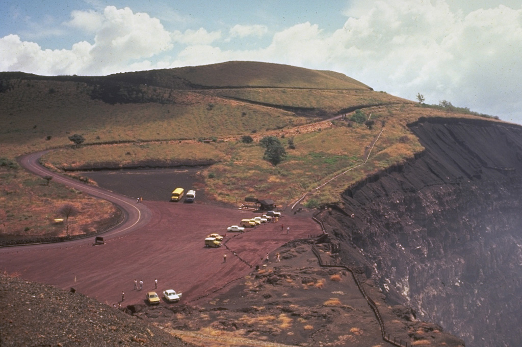
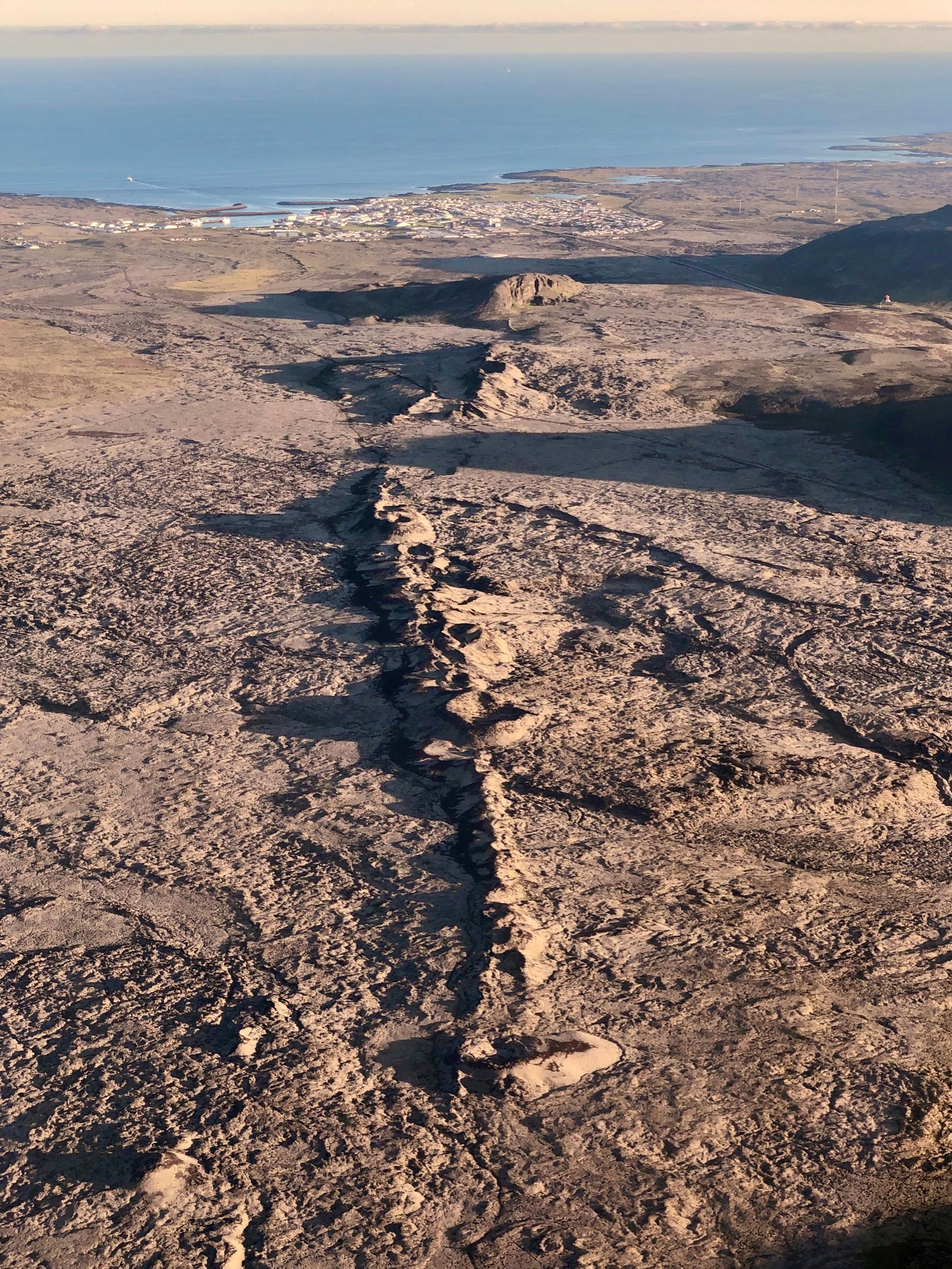
Eruptive activity decreased overnight during 16-17 March. Seismicity significantly decreased with only a few earthquakes recorded after 03h00 on 17 March, coinciding with decreased tremor. Lava flows to the S were diverted from Grindavík along the barriers towards the SE. The effusion rate decreased substantially at around 04h00, and lava was produced by a segment near the middle of the fissure that was 500 m long. By 13h00 lava fountaining was concentrated at three areas along the fissure. The S flow advanced at a rate of about 12 m per hour during 10h15-16h30 and a few hours later the leading lobe was about 330 m from Suðurstrandarvegur, the main road along the S coast of the Reykjanes Peninsula. During the morning sulfur dioxide emissions peaked at 15,000 micrograms per cubic meter and emissions detected by satellite that day were the highest measured of the recent 2023-2024 eruptions. Sulfur dioxide fluxes were as high as 50 kilograms per second. A news articles noted that some small lava ponds formed near the Grindavík barriers and at the flow near Suðurstrandarvegur. The area of the flow field was an estimated 5.85 square kilometers based on a satellite image acquired at 14h56 on 17 March.

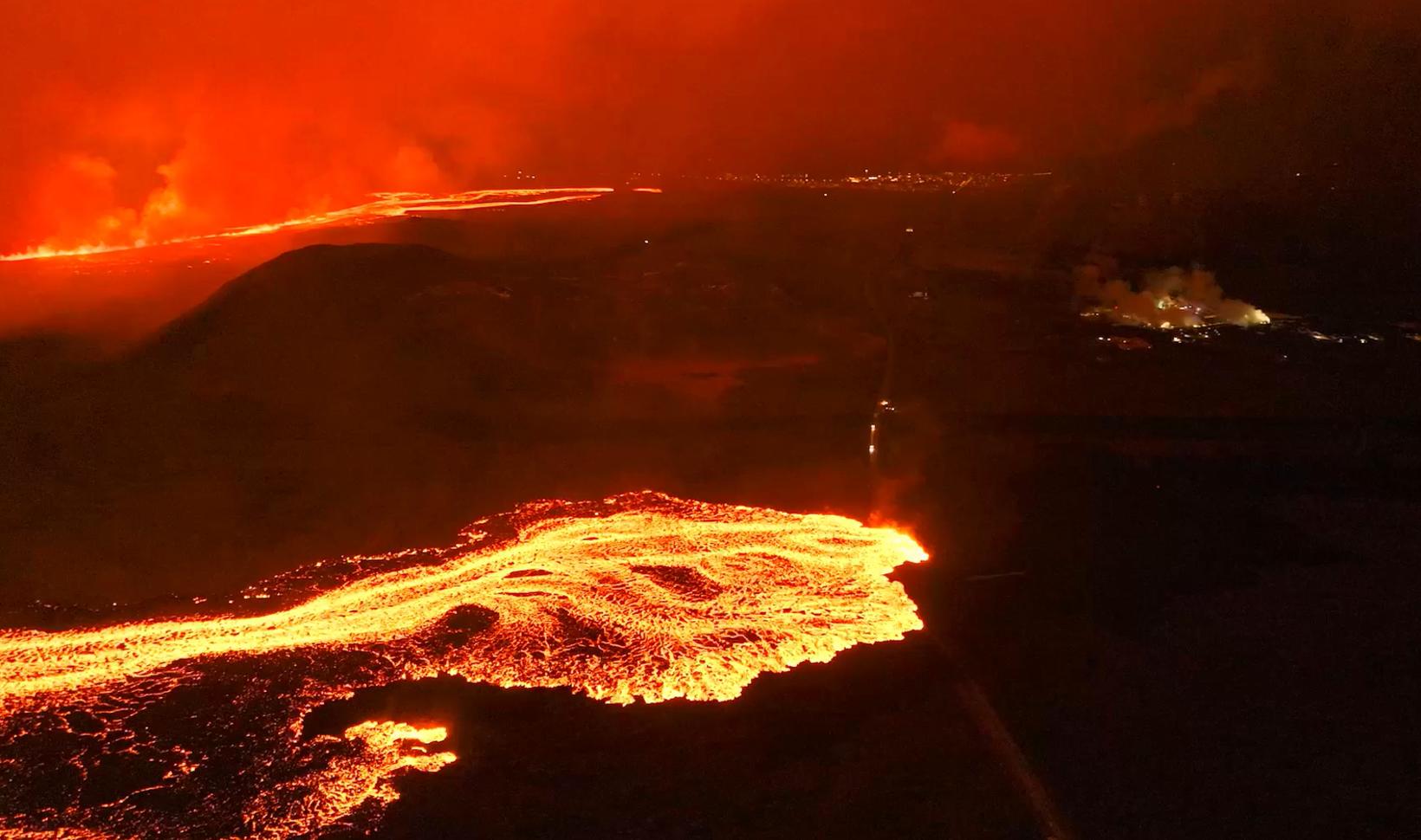
The eruption continued at stable levels during 18-19 March. Lava activity was concentrated at a series of vents which had built cones at the S end of the fissure; occasional fountaining was observed. The lava flows that had crossed Grindavíkurvegur and stopped near Suðurstrandarvegur were slow moving. Deformation data suggested that magma continued to flow into the dyke system. According to Almannavarnadeild ríkislögreglustjóra (National Commissioner of the Icelandic Police and Department of Civil Protection and Emergency Management) Grindavík residents were permitted to return to town on 19 March, though it was not recommended that they stay overnight. The Blue Lagoon remained closed.

Sources : GVP , IMO.

Photo : mbl.is/Hörður Kristleifsson


Colombia , Purace / Los Coconucos Volcanic Range :

Weekly activity bulletin: Puracé Volcano – Los Coconucos volcanic Range

From the monitoring of the activity of the PURACE VOLCANO – LOS COCONUCOS VOLCANIC CHAIN, the MINISTRY OF MINES AND ENERGY, through the COLOMBIAN GEOLOGICAL SERVICE (SGC), reports that:
In the week of March 12 to 18, 2024, seismic activity presented levels similar to those of previous weeks, both in seismic energy released and in the number of events.
The fracture earthquakes recorded were mainly located under the Puracé volcano edifice, with depths less than 6 km and magnitudes less than 1.1 ML; while the earthquakes associated with the fluids were located in two areas: one under the crater of the volcano, at depths less than 500 m, and another to the South-East of it, at depths between 1.5 and 6.0 km.

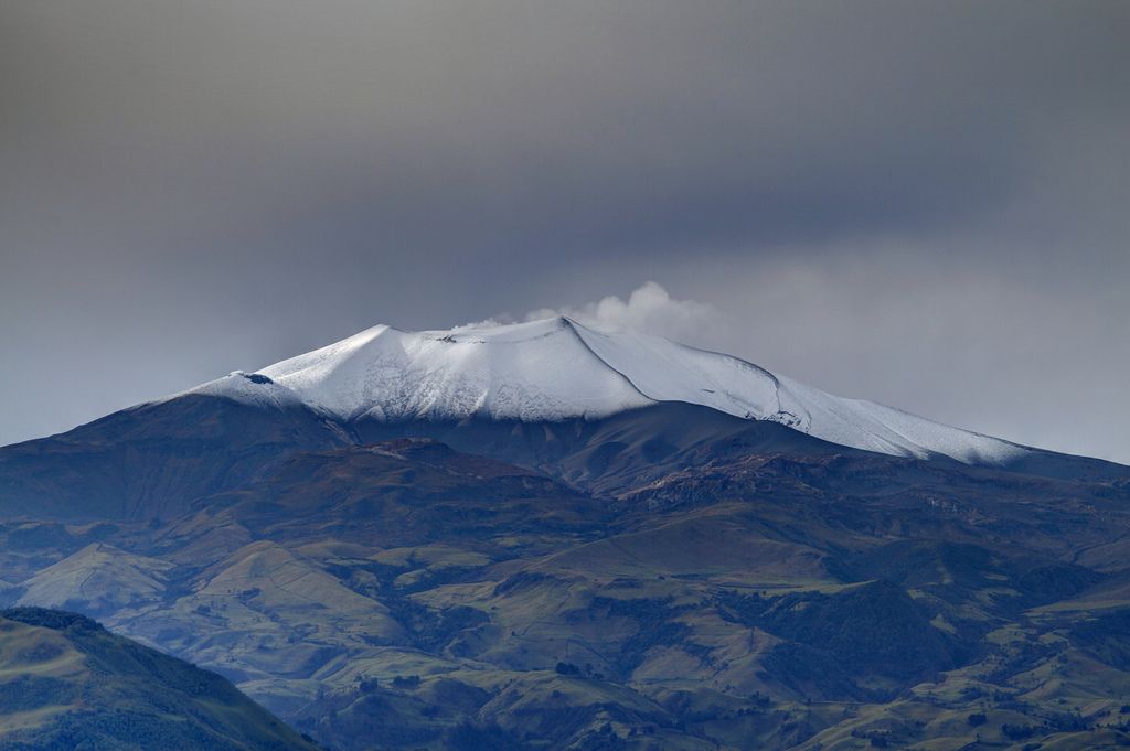
During the period evaluated, deformations continued to be recorded between the Puracé and Curiquinga volcanoes. Likewise, the concentration of carbon dioxide (CO2) continued to oscillate and remains above reference values on this volcano. The increase in sulfur dioxide (SO2) flux detected in previous weeks continued to be recorded.
Images obtained using installed cameras show that significant degassing of the volcanic system continues.
Other parameters measured and used for the assessment of volcanic activity showed no notable changes during the period evaluated.
The alert status for volcanic activity remains at: YELLOW ALERT: ACTIVE VOLCANO WITH CHANGES IN THE BEHAVIOR OF THE BASE LEVEL OF MONITORED PARAMETERS AND OTHER MANIFESTATIONS.

Source : SGC

Photo : José M. Arboleda


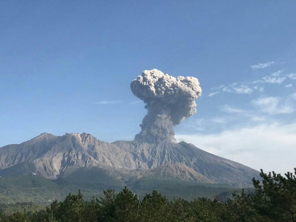
Indonesia , Semeru :

Mount Semeru erupted on Thursday, March 21, 2024, at 7:33 p.m. WIB. The height of the eruptive column was not observed. The eruption was recorded on a seismograph with a maximum amplitude of 22 mm and a duration of 111 seconds.

Issued : March 21 , 2024
Volcano : Semeru (263300)
Current Aviation Colour Code : ORANGE
Previous Aviation Colour Code : orange
Source : Semeru Volcano Observatory
Notice Number : 2024SMR201
Volcano Location : S 08 deg 06 min 29 sec E 112 deg 55 min 12 sec
Area : East java, Indonesia
Summit Elevation : 11763 FT (3676 M)

Volcanic Activity Summary :
Eruption at 12h33 UTC (1933 local).

Volcanic Cloud Height : Ash-cloud is not observed.

Other Volcanic Cloud Information : Ash-cloud is not observed.

Remarks :
Eruption recorded on seismogram with maximum amplitude 22 mm and maximum duration 111 second.

Observation of seismicity:
14 eruption earthquakes with an amplitude of 10 to 22 mm and a duration of 69 to 101 seconds.
9 emission earthquakes with an amplitude of 3 to 4 mm and duration of the earthquake from 25 to 52 seconds.
2 deep tectonic earthquakes with an amplitude of 13-30 mm, and earthquake duration 131-472 seconds.

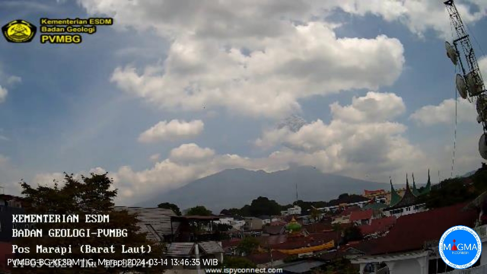
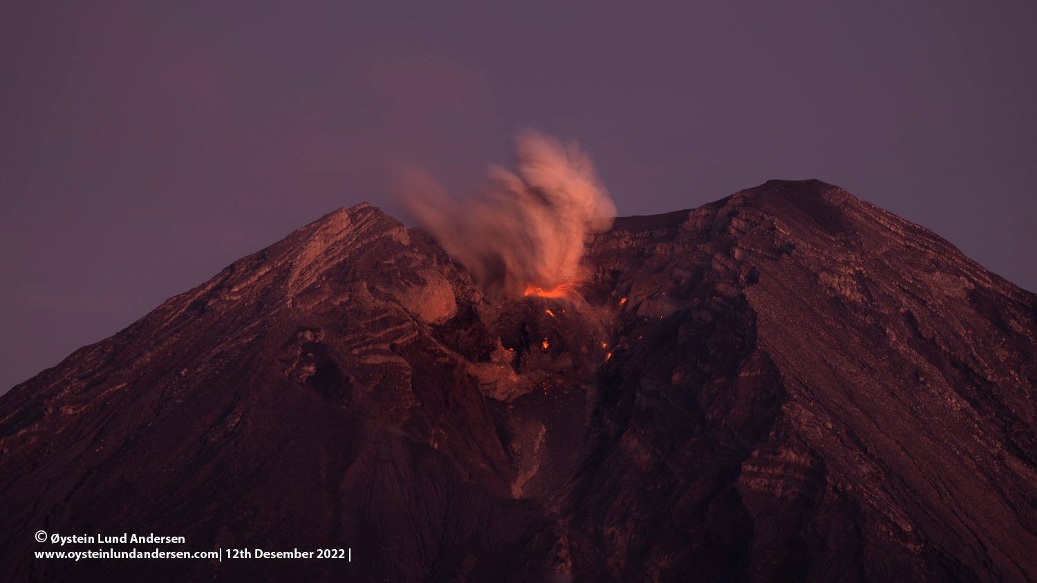
PVMBG reported that eruptive activity continued at Semeru during 13-19 March. Eruptive events were recorded at 00h47 on 15 March and at 16h53 on 17 March by the seismic network, though emissions were not observed. At 06h25 on 19 March a dense white-and-gray ash plume rose 500 m above the summit and drifted NE. The Alert Level remained at 3 (the third highest level on a scale of 1-4). The public was warned to stay at least 5 km away from the summit in all directions, 13 km from the summit to the SE, 500 m from the banks of the Kobokan drainage as far as 17 km from the summit, and to avoid other drainages including the Bang, Kembar, and Sat, due to lahar, avalanche, and pyroclastic flow hazards.

Sources : Magma indonésie , GVP.

Photo : Oystein Lund Andersen  ( archive)


Kamchatka , Sheveluch :

VOLCANO OBSERVATORY NOTICE FOR AVIATION (VONA)

Issued: March 21 , 2024
Volcano: Sheveluch (CAVW #300270)
Current aviation colour code: ORANGE
Previous aviation colour code: orange
Source: KVERT
Notice Number: 2024-13
Volcano Location: N 56 deg 38 min E 161 deg 18 min
Area: Kamchatka, Russia
Summit Elevation: 3283 m (10768.24 ft), the dome elevation ~2500 m (8200 ft)

Volcanic Activity Summary:
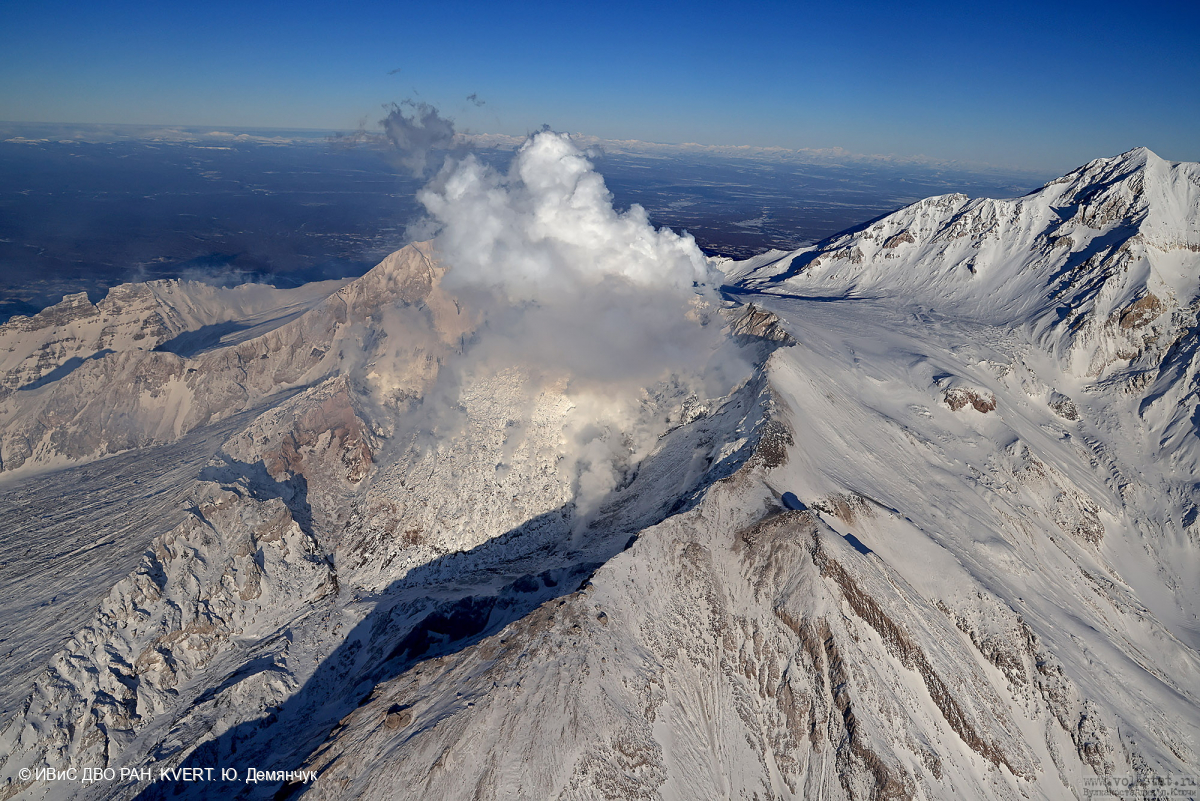
Video and satellite data by KVERT shows a strong wind lifts ash from the southern slopes of Sheveluch volcano, and a plume of resuspended ash is extending about 35 km to the eastsouth-east of the volcano.
An extrusive-effusive eruption of the volcano continues. A danger of ash explosions up to 6 km (19,700 ft) a.s.l. remains. Ongoing activity could affect low-flying aircraft.

Volcanic cloud height:
1500-2000 m (4920-6560 ft) AMSL Time and method of ash plume/cloud height determination: 20240321/2310Z – Video data

Other volcanic cloud information: Distance of ash plume/cloud of the volcano: 35 km (22 mi)
Direction of drift of ash plume/cloud of the volcano: ESE / azimuth 105 deg
Time and method of ash plume/cloud determination: 20240321/2240Z – Himawari-9 14m15

Remarks:
resuspended ash

Source : Kvert.

Photo : Yu. Demyanchuk. IVS FEB RAS, KVERT


Nicaragua , Massaya :

According to the U.S. Embassy in Nicaragua the Parque Nacional Volcán Masaya continued to be closed on 12 March due to an increased potential for explosive activity due to the blocking of the lava lake from landslide deposits in Santiago Crater. A satellite image from 13 March showed a slightly larger thermal anomaly on the NE crater floor compared to an 8 March image. According to a 13 March news article, INETER reported that landslides from the inner SW and NW crater walls were continuing. In a 14 March news article, a resident that lived near the volcano noted that the typical gas emissions seen before the 2 March landslide were no longer observed.

According to Ineter, landslides keep the lava lake covered, causing the secondary gas outlet temperature to increase by values above 545 degrees Celsius compared to normal.

Ineter explained that it had detected noises inside the volcano’s crater, following the rearrangement and subsidence of volcanic material.

These events come from the collision between rock fragments, which generates vibrations recorded in the form of seismic signals.

Sources :100% Noticias, Copernicus, Onda Local, U.S. Embassy in Nicaragua , GVP.

Photo : 100% noticias.

March 14, 2024. EN. Nicaragua : Massaya , Iceland : Reykjanes Peninsula , Vanuatu : Ambae , Indonesia : Marapi , Japan : Sakurajima .

March 14 , 2024.


Nicaragua , Massaya :

According to news articles, INETER reported that gas emissions increased at Masaya’s Santiago Crater in February, small landslides occurred from the inner NW crater wall, and the level of the lava lake had slightly increased. The report noted that SINAPRED recommended limits on the number of people and the time spent at the viewing area at the crater rim. A larger landslide occurred on 2 March and covered the active lava lake. A satellite image from 3 March showed a much smaller thermal anomaly on the crater floor compared to a 22 February image. According to an 8 March news article, INETER reported that small landslides continued to occur, originating from the inner SW and NW crater walls; a more notable landslide was recorded at 0900. The lava lakes remained covered with the deposits. Constant gas emissions rose from vents possibly on the crater floor and from fractures on the inner walls, though the gas flux was at lower rate, estimated to be 25-30 percent of the normal values. Seismicity was low with RSAM values around 23. The report noted that the Parque Nacional Volcán Masaya may partially open, though the public was warned to stay 800 m away from Santiago Crater.

Masaya volcano in Nicaragua has erupted frequently since the time of the Spanish Conquistadors, when an active lava lake prompted attempts to extract the volcano’s molten « gold » until it was found to be basalt rock upon cooling. It lies within the massive Pleistocene Las Sierras caldera and is itself a broad, 6 x 11 km basaltic caldera with steep-sided walls up to 300 m high. The caldera is filled on its NW end by more than a dozen vents that erupted along a circular, 4-km-diameter fracture system. The Nindirí and Masaya cones, the source of observed eruptions, were constructed at the southern end of the fracture system and contain multiple summit craters, including the currently active Santiago crater. A major basaltic Plinian tephra erupted from Masaya about 6,500 years ago. Recent lava flows cover much of the caldera floor and there is a lake at the far eastern end. A lava flow from the 1670 eruption overtopped the north caldera rim. Periods of long-term vigorous gas emission at roughly quarter-century intervals have caused health hazards and crop damage.

Sources : Copernic, La Prensa (Nicaragua), El 19 Digital , GVP.

Photo : gvp / Jaime Incer.


Iceland , Reykjanes Peninsula:

Continued increased likelihood of an eruption. Likely sequence of events over the next several days:
Updated 12. March at 17:00 UTC

The volume of magma beneath Svartsengi continues to increase, which could result in a new dike intrusion and possibly an eruption.
An eruption could occur with very short notice, possibly less than 30 minutes.
The most likely eruption site is between Stóra-Skógafell and Hagafell.
Model calculations show that magma accumulation at Svartsengi continues at a steady rate. In previous events a magma intrusion has formed when the volume of accumulated magma has reached 8 to 13 million cubic meters. The total volume accumulated now has already reach this threshold. Pressure buildup therefore continues to increase in the magma chamber and likelihood of a new dike intrusion and even an eruption in the next days is increased.

140 earthquakes have been detected in the vicinity of the Sundhnúkur crater row and Grindavík since Friday. The majority of these earthquakes have been minor or below magnitude 1.0 whilst the largest measured event was a M2.8 on Friday evening, at around 5km depth just SE of Þorbjörn. Seismic activity in the area has increased slightly in the past few days compared to last week, which can possibly be linked to calmer winds and optimal weather conditions for earthquake detections.

The IMO has updated the hazard assessment map. The hazard level remains unchanged from the last map. The new hazard assessment map took effect at 15:00 today, Tuesday, March 12th and is valid until March 19th, barring any changes to the situation.

Unusually rythmic pattern of unrest, upto this point.
As reported last week, the behavior of the dike propagation on March 2nd differed in some ways to the previous dike formations. Scientists will continue to gather data and infer if the event on March 2nd indicates possible changes to the unusually rythmic pattern of unrest with magma accumulation at Svartsengi and repeated dyke intusions and eruptions.

These events of unrest have previously been compared to the unrest in Krafla that started in 1975. During a period of 10 years, 20 magma intrusions occurred with 9 of them culminating in a volcanic eruption (See image below). In the Krafla unrest magma always intruded into the same dike, but at different scales of magnitude. However, the eruptions did not follow a similarly regular pattern as observed so far in the Sundhnúkar crater row and has in fact been unusually rythmic.

Source : IMO

Photos : IMO , Siggi Anton


 Vanuatu , Ambae :

The major unrest volcanic activity at Ambae is continuing at Lake Voui. Latest field observations and ongoing data analysis has confirmed that Ambae volcanic activity conditions is unstable at the major unrest level. The Ambae volcano activity is likely to continue at similar level, consistent with Volcanic Alert Level 2. The danger zone for life safety is limited at 2 km radius from the 2017-2018 active vents and flowing creeks during heavy rain.

Latest observation photos from the field showed that ongoing obvious emission of volcanic steam and/or gases and/or ashes are emitted from active vents inside Lake. With this ongoing volcanic activity, people of Ambae and neighboring islands can observe the volcanic cloud at the summit of Ambae Island. Volcanic hazards remain at the volcano summit area and flowing creeks (e.g. remobilization of remaining ash from 2017 and 2018 eruption). At this major unrest state, volcanic ash and acid rain can be also expected at villages located around the volcano summit specially those exposed to prevailing trade winds when the volcanic cloud reaching few kilometers in height.

On 8 March the Vanuatu Meteorology and Geohazards Department (VMGD) reported that emissions from the active vents at Ambae were ongoing based on recent field observations and photographs. The emissions contained gas, or steam, or ash, or some combination of all three. The Alert Level remained at 2 (on a scale of 0-5), and the public was warned to stay outside of the Danger Zone, defined as a 2-km radius around the active vents in Lake Voui, and away from drainages during heavy rains.

Sources : Vanuatu Meteorology and Geohazards Department  (VMGD) , GVP.

Photo : air taxi vanuatu ( archive).


Indonesia , Marapi :

An eruption of Mount Marapi occurred on Thursday, March 14, 2024 at 1:32 p.m. WIB with the height of the ash column observed at ± 1000 m above the summit (± 3891 m above sea level). The ash column was observed to be gray with thick intensity, oriented towards the East. At the time of writing, the eruption was still ongoing.

VOLCANO OBSERVATORY NOTICE FOR AVIATION – VONA

Issued : March 14 , 2024 .
Volcano : Marapi (261140)
Current Aviation Colour Code : ORANGE
Previous Aviation Colour Code : orange
Source : Marapi Volcano Observatory
Notice Number : 2024MAR026
Volcano Location : S 0 deg 22 min 52 sec E 100 deg 28 min 23 sec
Area : West Sumatra, Indonesia
Summit Elevation : 9251 FT (2891 M)

Volcanic Activity Summary :
Eruption with volcanic ash cloud at 06h32 UTC (13h32 local).

Volcanic Cloud Height :
Best estimate of ash-cloud top is around 12451 FT (3891 M) above sea level or 3200 FT (1000 M) above summit. May be higher than what can be observed clearly. Source of height data: ground observer.

Other Volcanic Cloud Information :
Ash cloud moving from east to southeast. Volcanic ash is observed to be gray. The intensity of volcanic ash is observed to be thick.

Remarks :
Eruption recorded on seismogram with maximum amplitude 30.3 mm and maximum duration 36 second. Tremor recorded on seismogram with maximum amplitude 2 mm.

PVMBG reported that eruptive activity at Marapi (in Sumatra) continued from March 6-12. Plumes of white and gray ash rose 250 to 700 m above the summit and drifted in several directions from March 6 to 8. White plumes of steam and gas rose 150 to 250 m above the summit and drifted northeast, east, and southeast from March 9 to 12. The alert level remained at 3 (on a scale of 1 to 4) and the public was warned to stay 4.5 km from the active crater.

Source et photo : Magma Indonésie.


Japan , Sakurajima :

JMA reported ongoing eruptive activity at Minamidake Crater (Aira Caldera’s Sakurajima volcano) during 4-11 March with nighttime crater incandescence. Very small eruptive events occasionally occurred during 4-8 March. An explosion at 03h59 on 9 March produced an ash plume that rose 800 m above the crater rim and drifted SE, and ejected large blocks 1.3-1.7 km from the vent. Eruptive events at 15h40 on 10 March and at 05h32 on 11 March generated ash plumes that rose 1.2-1.3 km above the crater rim and drifted E. An ash plume from an explosion at 21h32 on 11 March rose 1.4 km above the crater rim and drifted NE; large blocks were ejected 500-700 m from the vent. The Alert Level remained at 3 (on a 5-level scale), and the public was warned to stay 2 km away from both craters.

The Aira caldera in the northern half of Kagoshima Bay contains the post-caldera Sakurajima volcano, one of Japan’s most active. Eruption of the voluminous Ito pyroclastic flow accompanied formation of the 17 x 23 km caldera about 22,000 years ago. The smaller Wakamiko caldera was formed during the early Holocene in the NE corner of the caldera, along with several post-caldera cones. The construction of Sakurajima began about 13,000 years ago on the southern rim and built an island that was joined to the Osumi Peninsula during the major explosive and effusive eruption of 1914. Activity at the Kitadake summit cone ended about 4,850 years ago, after which eruptions took place at Minamidake. Frequent eruptions since the 8th century have deposited ash on the city of Kagoshima, located across Kagoshima Bay only 8 km from the summit. The largest recorded eruption took place during 1471-76.

Sources : Japan Meteorological Agency (JMA) , GVP.

Photo : Rizal M.

14 Mars 2024. FR. Nicaragua : Massaya , Islande : Péninsule de Reykjanes , Vanuatu : Ambae , Indonésie : Marapi , Japon : Sakurajima .

14 Mars 2024.


Nicaragua , Massaya :

Selon des articles de presse, l’INETER a rapporté que les émissions de gaz ont augmenté dans le cratère Santiago du Masaya en février, que de petits glissements de terrain se sont produits à partir de la paroi intérieure du cratère Nord-Ouest et que le niveau du lac de lave a légèrement augmenté. Le rapport note que le SINAPRED recommande de limiter le nombre de personnes et le temps passé dans la zone d’observation au bord du cratère. Un glissement de terrain plus important s’est produit le 2 mars et a recouvert le lac de lave actif. Une image satellite du 3 mars a montré une anomalie thermique beaucoup plus petite au fond du cratère par rapport à une image du 22 février. Selon un article de presse du 8 mars, l’INETER a signalé que de petits glissements de terrain continuaient de se produire, provenant des parois intérieures du cratère Sud-Ouest et Nord-Ouest ; un glissement de terrain plus notable a été enregistré à 9 heures. Les lacs de lave sont restés recouverts de dépôts. Les émissions constantes de gaz ont augmenté à cause des évents éventuellement au fond du cratère et des fractures sur les parois internes, bien que le flux de gaz ait été plus faible, estimé à 25-30 pour cent des valeurs normales. La sismicité était faible avec des valeurs RSAM autour de 23. Le rapport note que le parc national du volcan Masaya pourrait s’ouvrir partiellement, bien que le public ait été averti de rester à 800 m du cratère Santiago.

Le volcan Masaya au Nicaragua est entré en éruption fréquemment depuis l’époque des conquistadors espagnols, lorsqu’un lac de lave actif a incité à tenter d’extraire « l’or » fondu du volcan jusqu’à ce qu’il se révèle être une roche basaltique après refroidissement. Il se trouve dans la caldeira massive , datant du Pléistocène , de Las Sierras et est lui-même une large caldeira basaltique de 6 x 11 km avec des parois abruptes atteignant 300 m de haut. La caldeira est remplie à son extrémité Nord-Ouest par plus d’une douzaine d’évents qui ont grandi le long d’un système de fractures circulaire de 4 km de diamètre. Les cônes Nindirí et Masaya, à l’origine des éruptions observées, ont été construits à l’extrémité Sud du système de fractures et contiennent plusieurs cratères sommitaux, dont le cratère Santiago actuellement actif. Un téphra basaltique plinien majeur est apparu sur le Masaya il y a environ 6 500 ans. Des coulées de lave récentes couvrent une grande partie du fond de la caldeira et il y a un lac à l’extrémité Est. Une coulée de lave issue de l’éruption de 1670 a dépassé le bord Nord de la caldeira. Des périodes d’émissions de gaz vigoureuses à long terme, à intervalles d’environ un quart de siècle, ont entraîné des risques pour la santé et des dommages aux cultures.

Sources : Copernic, La Prensa (Nicaragua), El 19 Digital , GVP.

Photo : gvp / Jaime Incer.


Islande , Péninsule de Reykjanes :

Probabilité toujours accrue d’une éruption . Déroulement probable des événements au cours des prochains jours :
Mise à jour le 12 mars à 17h00 UTC.

Le volume de magma sous Svartsengi continue d’augmenter, ce qui pourrait entraîner une nouvelle intrusion de dyke et éventuellement une éruption.
Une éruption pourrait survenir dans un délai très court, peut-être moins de 30 minutes.
Le site d’éruption le plus probable se situe entre Stóra-Skógafell et Hagafell.
Les calculs du modèle montrent que l’accumulation de magma à Svartsengi se poursuit à un rythme constant. Lors d’événements précédents, une intrusion magmatique s’est formée lorsque le volume de magma accumulé a atteint 8 à 13 millions de mètres cubes. Le volume total accumulé a désormais déjà atteint ce seuil. L’accumulation de pression continue donc d’augmenter dans la chambre magmatique et la probabilité d’une nouvelle intrusion de dykes, voire d’une éruption dans les prochains jours, augmente.

Depuis vendredi, 140 tremblements de terre ont été détectés à proximité de la rangée de cratères de Sundhnúkur et de Grindavík. La majorité de ces tremblements de terre ont été mineurs ou inférieurs à une magnitude de 1,0, tandis que l’événement le plus important mesuré était de M2,8 vendredi soir, à environ 5 km de profondeur, juste au Sud-Est de Þorbjörn. L’activité sismique dans la zone a légèrement augmenté ces derniers jours par rapport à la semaine dernière, ce qui peut éventuellement être lié à des vents plus calmes et à des conditions météorologiques optimales pour la détection des tremblements de terre.

L’OMI a mis à jour la carte d’évaluation des risques. Le niveau de danger reste inchangé par rapport à la dernière carte. La nouvelle carte d’évaluation des risques est entrée en vigueur aujourd’hui mardi 12 mars à 15 heures et est valable jusqu’au 19 mars, sauf changement de situation.

Un rythme de troubles inhabituellement rythmé, jusqu’à présent.
Comme indiqué la semaine dernière, le comportement de la propagation des dykes le 2 mars différait à certains égards de celui des formations de dykes précédentes. Les scientifiques continueront de collecter des données et de déduire si l’événement du 2 mars indique des changements possibles dans le schéma inhabituellement rythmique des troubles avec une accumulation de magma à Svartsengi et des intrusions et éruptions répétées de dykes.

Ces événements de troubles ont déjà été comparés aux troubles du Krafla qui ont commencé en 1975. Au cours d’une période de 10 ans, 20 intrusions de magma se sont produites, dont 9 ont abouti à une éruption volcanique. Lors des troubles du Krafla, le magma a toujours pénétré dans le même dyke, mais à des échelles de grandeur différentes. Cependant, les éruptions n’ont pas suivi un schéma aussi régulier que celui observé jusqu’à présent dans la rangée de cratères de Sundhnúkar ( photo) et ont en fait été inhabituellement rythmées.

Source : IMO

Photos : IMO , Siggi Anton


 Vanuatu , Ambae :

L’activité volcanique majeure sur Ambae se poursuit dans le lac Voui. Les dernières observations sur le terrain et l’analyse des données en cours ont confirmé que les conditions d’activité volcanique d’Ambae sont instables au niveau des troubles . L’activité du volcan Ambae est susceptible de se poursuivre à un niveau similaire, conforme au niveau d’alerte volcanique 2. La zone de danger pour la sécurité des personnes est limitée à un rayon de 2 km des bouches d’évents actives de 2017-2018 et des ruisseaux qui coulent en cas de fortes pluies.

Les dernières photos d’observation sur le terrain ont montré que des émissions évidentes et continues de vapeur volcanique et/ou de gaz et/ou de cendres sont émises par des évents actifs à l’intérieur du lac. Avec cette activité volcanique continue, les habitants d’Ambae et des îles voisines peuvent observer le nuage volcanique au sommet de l’île d’Ambae. Des risques volcaniques subsistent dans la zone du sommet du volcan et dans les ruisseaux (par exemple, remobilisation des cendres restantes des éruptions de 2017 et 2018). Dans cet état de troubles majeurs, des cendres volcaniques et des pluies acides peuvent également être attendues dans les villages situés autour du sommet du volcan, en particulier ceux exposés aux alizés dominants lorsque le nuage volcanique atteint quelques kilomètres de hauteur.

Le 8 mars, le Département de météorologie et de géorisques de Vanuatu (VMGD) a signalé que les émissions des évents actifs d’Ambae se poursuivaient sur la base d’observations et de photographies récentes sur le terrain. Les émissions contenaient du gaz, de la vapeur, ou des cendres, ou une combinaison des trois. Le niveau d’alerte est resté à 2 (sur une échelle de 0 à 5) et le public a été averti de rester en dehors de la zone de danger, définie comme un rayon de 2 km autour des bouches d’évents actives du lac Voui, et à l’écart des drainages lors de fortes pluies.  

Sources : Département de météorologie et de géorisques de Vanuatu (VMGD) , GVP.

Photo : air taxi vanuatu ( archive).


Indonésie , Marapi :

Une éruption du mont Marapi s’est produite le jeudi 14 mars 2024 à 13h32 WIB avec la hauteur de la colonne de cendres observée à ± 1000 m au-dessus du sommet (± 3891 m au-dessus du niveau de la mer). La colonne de cendres a été observée comme étant grise avec une intensité épaisse , orientée vers l’Est. Au moment de la rédaction de ce rapport, l’éruption était toujours en cours.

AVIS D’OBSERVATION DU VOLCAN POUR L’AVIATION – VONA

Publié : 14 mars 2024 .
Volcan : Marapi (261140)
Code couleur aviation actuel : ORANGE
Code couleur aviation précédent : orange
Source : Observatoire du Volcan Marapi
Numéro d’avis : 2024MAR026
Localisation du volcan : S 0 deg 22 min 52 sec E 100 deg 28 min 23 sec
Zone : Ouest de Sumatra, Indonésie
Altitude du sommet : 9 251 pieds (2 891 M)

Résumé de l’activité volcanique :
Éruption avec nuage de cendres volcaniques à 06h32 UTC (13h32 locale).

Hauteur des Nuages Volcaniques :
La meilleure estimation du sommet du nuage de cendres se situe à environ 12 451 pieds (3 891 m) au-dessus du niveau de la mer ou 3 200 pieds (1 000 m) au-dessus du sommet. Peut être supérieur à ce qui peut être observé clairement. Source des données de hauteur : observateur au sol.

Autres informations sur les nuages volcaniques :
Nuage de cendres se déplaçant d’Est en Sud-Est. Les cendres volcaniques sont grises. L’intensité des cendres volcaniques est observée comme étant épaisse.

Remarques :
Éruption enregistrée sur sismogramme avec une amplitude maximale de 30,3 mm et une durée maximale de 36 secondes. Tremor enregistré sur sismogramme avec une amplitude maximale de 2 mm.

Le PVMBG a signalé que l’activité éruptive du Marapi (à Sumatra) s’est poursuivie du 6 au 12 mars. Des panaches de cendres blanches et grises se sont élevés de 250 à 700 m au-dessus du sommet et ont dérivé dans plusieurs directions du 6 au 8 mars. Des panaches blancs de vapeur et de gaz se sont élevés de 150 à 250 m au-dessus du sommet et ont dérivé vers le Nord-Est, l’Est et le Sud-Est du 9 au 12 mars. Le niveau d’alerte est resté à 3 (sur une échelle de 1 à 4) et le public a été averti de rester à 4,5 km du cratère actif.

Source et photo : Magma Indonésie.


Japon , Sakurajima :

Le JMA a signalé une activité éruptive continue dans le cratère Minamidake (sur le volcan Sakurajima de la caldeira d’Aira) du 4 au 11 mars avec une incandescence nocturne du cratère. De très petits événements éruptifs se sont produits occasionnellement du 4 au 8 mars. Une explosion à 03h59 le 9 mars a produit un panache de cendres qui s’est élevé à 800 m au-dessus du bord du cratère et a dérivé vers le Sud-Est, et a éjecté de gros blocs à 1,3-1,7 km de l’évent. Les événements éruptifs à 15 h 40 le 10 mars et à 5 h 32 le 11 mars ont généré des panaches de cendres qui se sont élevés de 1,2 à 1,3 km au-dessus du bord du cratère et ont dérivé vers l’Est. Un panache de cendres provenant d’une explosion à 21 h 32 le 11 mars s’est élevé de 1,4 km au-dessus du bord du cratère et a dérivé vers le Nord-Est; de gros blocs ont été éjectés à 500-700 m de l’évent. Le niveau d’alerte est resté à 3 (sur une échelle de 5 niveaux) et le public a été averti de rester à 2 km des deux cratères.

La caldeira d’Aira, dans la moitié Nord de la baie de Kagoshima, contient le volcan Sakurajima post-caldeira, l’un des plus actifs du Japon. L’éruption de la volumineuse coulée pyroclastique d’Ito a accompagné la formation de la caldeira de 17 x 23 km il y a environ 22 000 ans. La plus petite caldeira de Wakamiko s’est formée au début de l’Holocène dans le coin Nord-Est de la caldeira, avec plusieurs cônes post-caldeira. La construction du Sakurajima a commencé il y a environ 13 000 ans sur la rive Sud et a donné naissance à une île qui a été reliée à la péninsule d’Osumi lors de l’éruption explosive et effusive majeure de 1914. L’activité au cône sommital de Kitadake a pris fin il y a environ 4 850 ans, après quoi les éruptions ont duré lieu depuis le cratère Minamidake. De fréquentes éruptions depuis le VIIIe siècle ont déposé des cendres sur la ville de Kagoshima, située de l’autre côté de la baie de Kagoshima, à seulement 8 km du sommet. La plus grande éruption enregistrée a eu lieu entre 1471 et 1476.

Sources : Agence météorologique japonaise (JMA) , GVP.

Photo : Rizal M.