March 14 , 2024.
Nicaragua , Massaya :
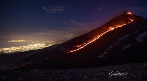
According to news articles, INETER reported that gas emissions increased at Masaya’s Santiago Crater in February, small landslides occurred from the inner NW crater wall, and the level of the lava lake had slightly increased. The report noted that SINAPRED recommended limits on the number of people and the time spent at the viewing area at the crater rim. A larger landslide occurred on 2 March and covered the active lava lake. A satellite image from 3 March showed a much smaller thermal anomaly on the crater floor compared to a 22 February image. According to an 8 March news article, INETER reported that small landslides continued to occur, originating from the inner SW and NW crater walls; a more notable landslide was recorded at 0900. The lava lakes remained covered with the deposits. Constant gas emissions rose from vents possibly on the crater floor and from fractures on the inner walls, though the gas flux was at lower rate, estimated to be 25-30 percent of the normal values. Seismicity was low with RSAM values around 23. The report noted that the Parque Nacional Volcán Masaya may partially open, though the public was warned to stay 800 m away from Santiago Crater.
Masaya volcano in Nicaragua has erupted frequently since the time of the Spanish Conquistadors, when an active lava lake prompted attempts to extract the volcano’s molten « gold » until it was found to be basalt rock upon cooling. It lies within the massive Pleistocene Las Sierras caldera and is itself a broad, 6 x 11 km basaltic caldera with steep-sided walls up to 300 m high. The caldera is filled on its NW end by more than a dozen vents that erupted along a circular, 4-km-diameter fracture system. The Nindirí and Masaya cones, the source of observed eruptions, were constructed at the southern end of the fracture system and contain multiple summit craters, including the currently active Santiago crater. A major basaltic Plinian tephra erupted from Masaya about 6,500 years ago. Recent lava flows cover much of the caldera floor and there is a lake at the far eastern end. A lava flow from the 1670 eruption overtopped the north caldera rim. Periods of long-term vigorous gas emission at roughly quarter-century intervals have caused health hazards and crop damage.
Sources : Copernic, La Prensa (Nicaragua), El 19 Digital , GVP.
Photo : gvp / Jaime Incer.
Iceland , Reykjanes Peninsula:
Continued increased likelihood of an eruption. Likely sequence of events over the next several days:
Updated 12. March at 17:00 UTC
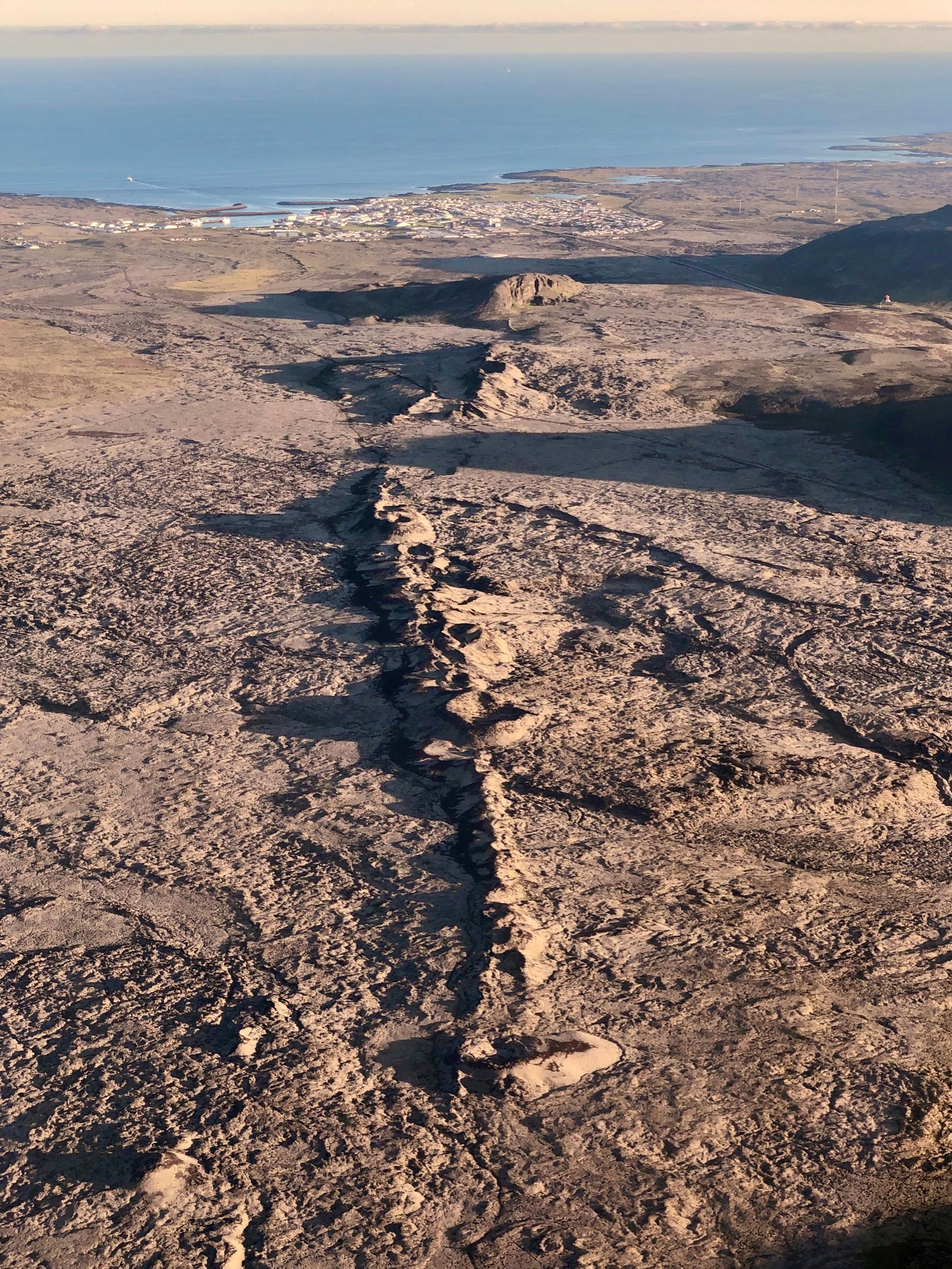
The volume of magma beneath Svartsengi continues to increase, which could result in a new dike intrusion and possibly an eruption.
An eruption could occur with very short notice, possibly less than 30 minutes.
The most likely eruption site is between Stóra-Skógafell and Hagafell.
Model calculations show that magma accumulation at Svartsengi continues at a steady rate. In previous events a magma intrusion has formed when the volume of accumulated magma has reached 8 to 13 million cubic meters. The total volume accumulated now has already reach this threshold. Pressure buildup therefore continues to increase in the magma chamber and likelihood of a new dike intrusion and even an eruption in the next days is increased.
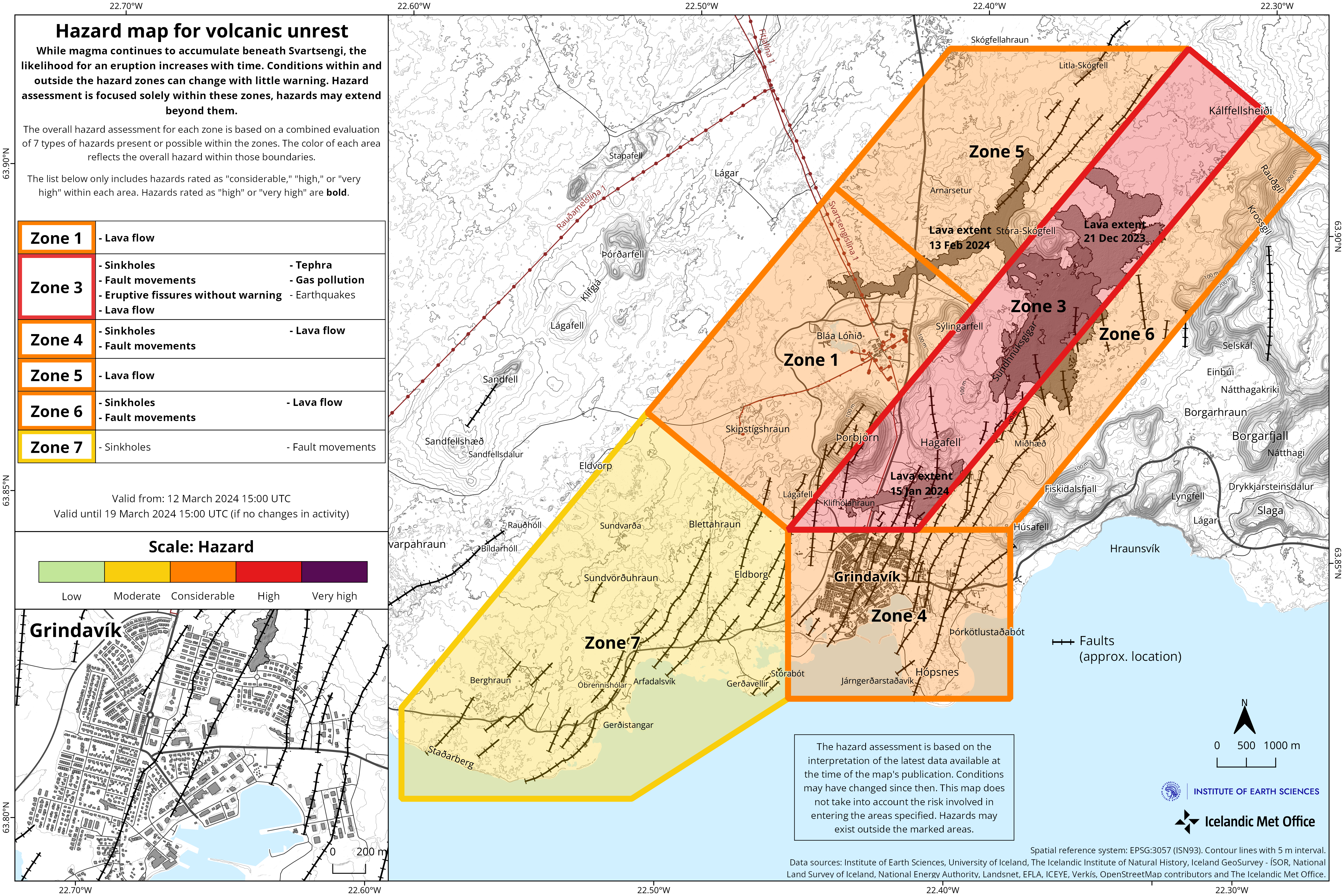
140 earthquakes have been detected in the vicinity of the Sundhnúkur crater row and Grindavík since Friday. The majority of these earthquakes have been minor or below magnitude 1.0 whilst the largest measured event was a M2.8 on Friday evening, at around 5km depth just SE of Þorbjörn. Seismic activity in the area has increased slightly in the past few days compared to last week, which can possibly be linked to calmer winds and optimal weather conditions for earthquake detections.
The IMO has updated the hazard assessment map. The hazard level remains unchanged from the last map. The new hazard assessment map took effect at 15:00 today, Tuesday, March 12th and is valid until March 19th, barring any changes to the situation.
Unusually rythmic pattern of unrest, upto this point.
As reported last week, the behavior of the dike propagation on March 2nd differed in some ways to the previous dike formations. Scientists will continue to gather data and infer if the event on March 2nd indicates possible changes to the unusually rythmic pattern of unrest with magma accumulation at Svartsengi and repeated dyke intusions and eruptions.
These events of unrest have previously been compared to the unrest in Krafla that started in 1975. During a period of 10 years, 20 magma intrusions occurred with 9 of them culminating in a volcanic eruption (See image below). In the Krafla unrest magma always intruded into the same dike, but at different scales of magnitude. However, the eruptions did not follow a similarly regular pattern as observed so far in the Sundhnúkar crater row and has in fact been unusually rythmic.
Source : IMO
Photos : IMO , Siggi Anton
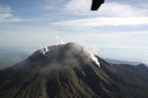
Vanuatu , Ambae :
The major unrest volcanic activity at Ambae is continuing at Lake Voui. Latest field observations and ongoing data analysis has confirmed that Ambae volcanic activity conditions is unstable at the major unrest level. The Ambae volcano activity is likely to continue at similar level, consistent with Volcanic Alert Level 2. The danger zone for life safety is limited at 2 km radius from the 2017-2018 active vents and flowing creeks during heavy rain.
Latest observation photos from the field showed that ongoing obvious emission of volcanic steam and/or gases and/or ashes are emitted from active vents inside Lake. With this ongoing volcanic activity, people of Ambae and neighboring islands can observe the volcanic cloud at the summit of Ambae Island. Volcanic hazards remain at the volcano summit area and flowing creeks (e.g. remobilization of remaining ash from 2017 and 2018 eruption). At this major unrest state, volcanic ash and acid rain can be also expected at villages located around the volcano summit specially those exposed to prevailing trade winds when the volcanic cloud reaching few kilometers in height.
On 8 March the Vanuatu Meteorology and Geohazards Department (VMGD) reported that emissions from the active vents at Ambae were ongoing based on recent field observations and photographs. The emissions contained gas, or steam, or ash, or some combination of all three. The Alert Level remained at 2 (on a scale of 0-5), and the public was warned to stay outside of the Danger Zone, defined as a 2-km radius around the active vents in Lake Voui, and away from drainages during heavy rains.
Sources : Vanuatu Meteorology and Geohazards Department (VMGD) , GVP.
Photo : air taxi vanuatu ( archive).
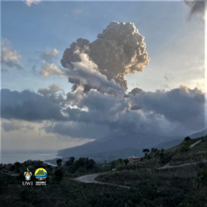
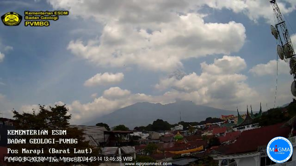
Indonesia , Marapi :
An eruption of Mount Marapi occurred on Thursday, March 14, 2024 at 1:32 p.m. WIB with the height of the ash column observed at ± 1000 m above the summit (± 3891 m above sea level). The ash column was observed to be gray with thick intensity, oriented towards the East. At the time of writing, the eruption was still ongoing.
VOLCANO OBSERVATORY NOTICE FOR AVIATION – VONA
Issued : March 14 , 2024 .
Volcano : Marapi (261140)
Current Aviation Colour Code : ORANGE
Previous Aviation Colour Code : orange
Source : Marapi Volcano Observatory
Notice Number : 2024MAR026
Volcano Location : S 0 deg 22 min 52 sec E 100 deg 28 min 23 sec
Area : West Sumatra, Indonesia
Summit Elevation : 9251 FT (2891 M)
Volcanic Activity Summary :
Eruption with volcanic ash cloud at 06h32 UTC (13h32 local).
Volcanic Cloud Height :
Best estimate of ash-cloud top is around 12451 FT (3891 M) above sea level or 3200 FT (1000 M) above summit. May be higher than what can be observed clearly. Source of height data: ground observer.
Other Volcanic Cloud Information :
Ash cloud moving from east to southeast. Volcanic ash is observed to be gray. The intensity of volcanic ash is observed to be thick.
Remarks :
Eruption recorded on seismogram with maximum amplitude 30.3 mm and maximum duration 36 second. Tremor recorded on seismogram with maximum amplitude 2 mm.
PVMBG reported that eruptive activity at Marapi (in Sumatra) continued from March 6-12. Plumes of white and gray ash rose 250 to 700 m above the summit and drifted in several directions from March 6 to 8. White plumes of steam and gas rose 150 to 250 m above the summit and drifted northeast, east, and southeast from March 9 to 12. The alert level remained at 3 (on a scale of 1 to 4) and the public was warned to stay 4.5 km from the active crater.
Source et photo : Magma Indonésie.
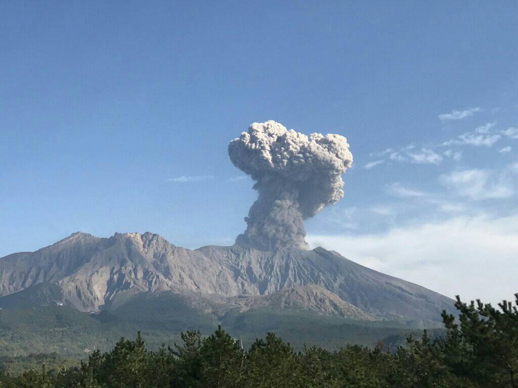
Japan , Sakurajima :
JMA reported ongoing eruptive activity at Minamidake Crater (Aira Caldera’s Sakurajima volcano) during 4-11 March with nighttime crater incandescence. Very small eruptive events occasionally occurred during 4-8 March. An explosion at 03h59 on 9 March produced an ash plume that rose 800 m above the crater rim and drifted SE, and ejected large blocks 1.3-1.7 km from the vent. Eruptive events at 15h40 on 10 March and at 05h32 on 11 March generated ash plumes that rose 1.2-1.3 km above the crater rim and drifted E. An ash plume from an explosion at 21h32 on 11 March rose 1.4 km above the crater rim and drifted NE; large blocks were ejected 500-700 m from the vent. The Alert Level remained at 3 (on a 5-level scale), and the public was warned to stay 2 km away from both craters.
The Aira caldera in the northern half of Kagoshima Bay contains the post-caldera Sakurajima volcano, one of Japan’s most active. Eruption of the voluminous Ito pyroclastic flow accompanied formation of the 17 x 23 km caldera about 22,000 years ago. The smaller Wakamiko caldera was formed during the early Holocene in the NE corner of the caldera, along with several post-caldera cones. The construction of Sakurajima began about 13,000 years ago on the southern rim and built an island that was joined to the Osumi Peninsula during the major explosive and effusive eruption of 1914. Activity at the Kitadake summit cone ended about 4,850 years ago, after which eruptions took place at Minamidake. Frequent eruptions since the 8th century have deposited ash on the city of Kagoshima, located across Kagoshima Bay only 8 km from the summit. The largest recorded eruption took place during 1471-76.
Sources : Japan Meteorological Agency (JMA) , GVP.
Photo : Rizal M.