April 30 , 2024.
Indonesia , Ruang :
Increase in activity level of G. Ruang from level III (SIAGA) to level IV (AWAS)
The evaluation report on the activity of G. Ruang, North Sulawesi is hereby submitted as follows:
I. Visual observation
G. Ruang’s visual observations for the period April 15-30, 2024 generally showed the mountain clearly until it was covered in fog. Smoke from the main crater was observed white, gray and black in color with low, medium to thick intensity at a height of approximately 50 to 1,800 meters above the summit.
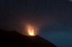
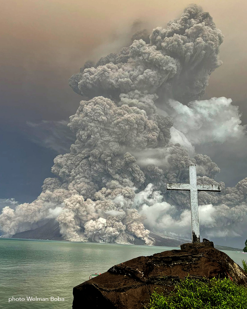
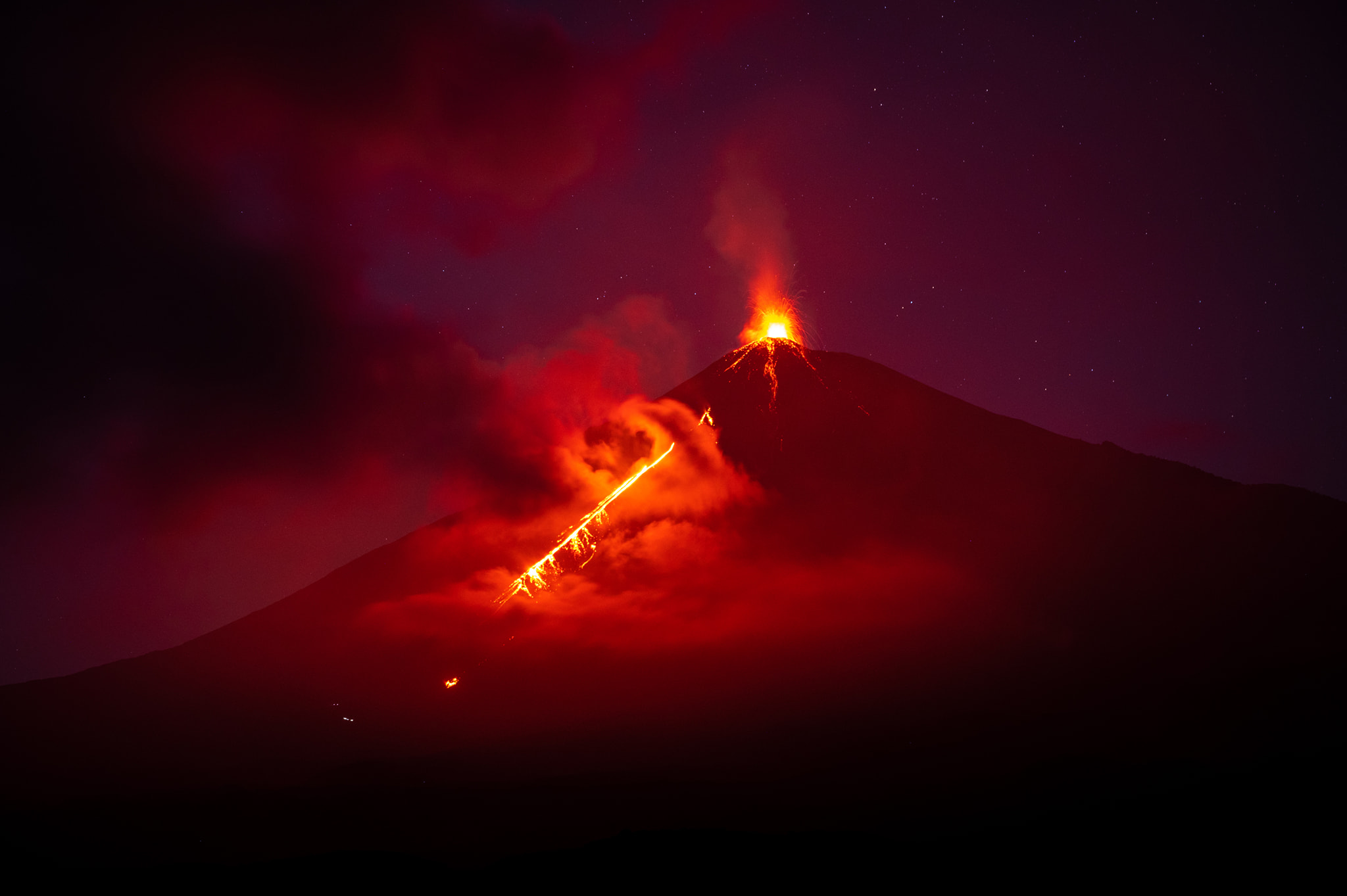
On April 30, 2024 at 01:15 WITA, an eruption occurred with the height of the eruptive column reaching 2,000 meters above the summit of G. Ruang. The eruption was accompanied by roaring sounds and the tremor was felt continuously.
II. Instrumental observation
Between April 1 and 28, 2024, the earthquakes recorded on G. Ruang were:
6 eruptions/explosions earthquakes,
15 avalanche earthquakes
1 harmonic tremor,
1 non-harmonic tremor,
3 continuous tremors,
2,057 deep volcanic earthquakes (VTA),
1,018 superficial volcanic earthquakes (VTB),
32 times local tectonic earthquakes,
195 Deep tectonic earthquakes.
The earthquakes were recorded 7 times on the MMI I scale. The G. Ruang seismic station was damaged due to the eruption on April 17, then the Geological Agency team installed a replacement station at the Ruang PGA station and began operations on April 20, 2024.
On April 29, 2024, the period 00:00-24:00 WITA recorded:
15 avalanche earthquakes
237 shallow volcanic earthquakes,
425 times deep volcanic earthquakes,
15 local tectonic earthquakes,
6 distant tectonic earthquakes.
During this period, there was another increase in seismicity on Mount Ruang, particularly in the number of deep volcanic earthquakes.
III. Assessment
The number of deep and shallow volcanic earthquakes, which increased significantly on April 29, 2024, accompanied by visuals of smoke from the crater, shows that there is currently still a process of rock cracking accompanied by magma migration deep magma reservoirs towards the surface. This increase in activity has the potential to develop into explosive eruptions alternating with effusive eruptions (lava flows). The tremor was intense from 00:15 WITA until the eruption occurred at 01:15 WITA and continued intensely until this status increase bulletin was issued. The eruption occurred at 01:15 WITA with an eruption column of approximately 2,000 meters accompanied by roars and intense tremor felt.
IV. Recommendation
Based on the results of visual and instrumental monitoring which show an increase in volcanic activity on Mount Ruang, the activity level of Mount Ruang was raised from level III (SIAGA) to level IV (AWAS) from from April 30, 2024 at 1:30 a.m. WITA.
VOLCANO OBSERVATORY NOTICE FOR AVIATION – VONA
Issued : April 30 , 2024
Volcano : Ruang (267010)
Current Aviation Colour Code : ORANGE
Previous Aviation Colour Code : orange
Source : Ruang Volcano Observatory
Notice Number : 2024RUA007
Volcano Location : N 02 deg 18 min 11 sec E 125 deg 22 min 00 sec
Area : North Sulawesi, Indonesia
Summit Elevation : 2320 FT (725 M)
Volcanic Activity Summary :
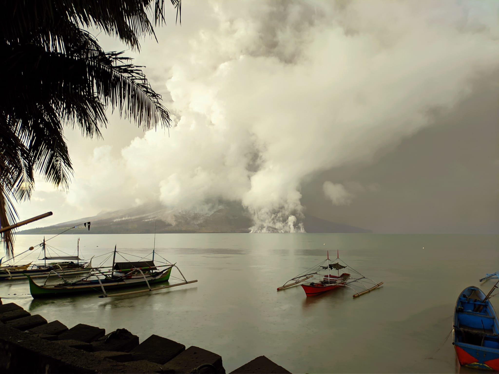
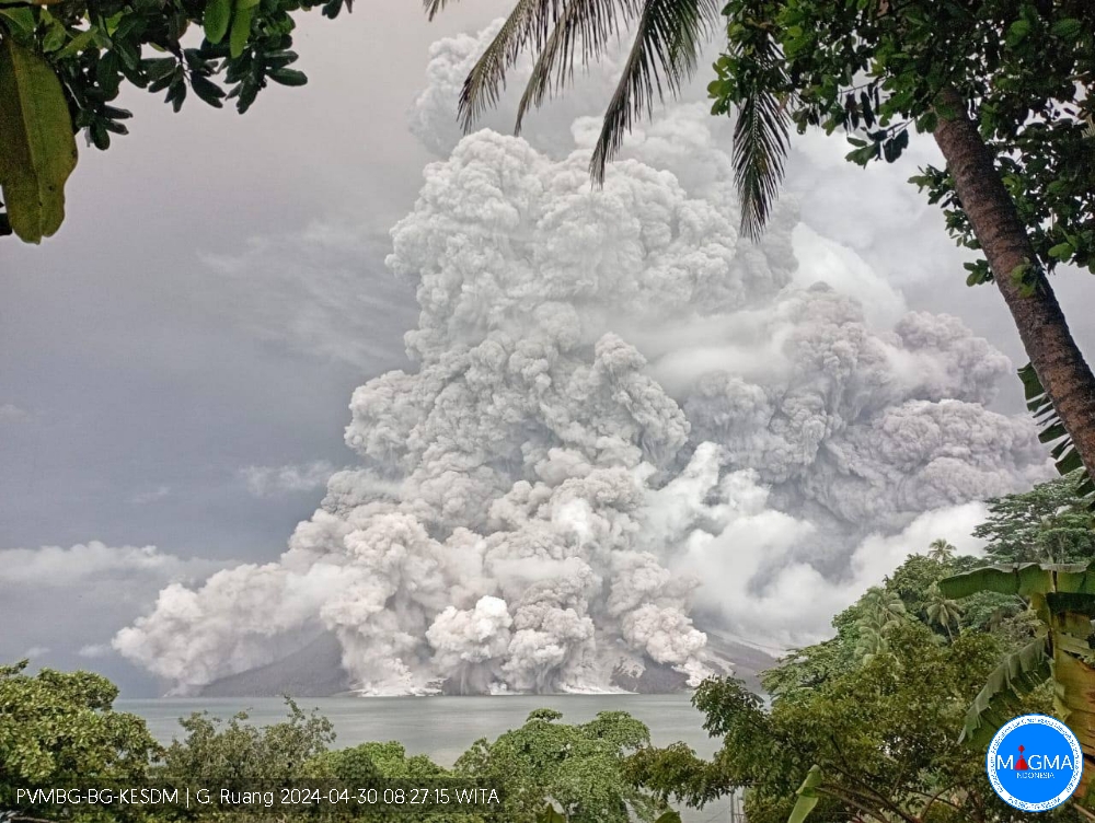
Eruption with volcanic ash cloud at 00h35 UTC (08h35 local).
Volcanic Cloud Height :
Best estimate of ash-cloud top is around 18320 FT (5725 M) above sea level or 16000 FT (5000 M) above summit. May be higher than what can be observed clearly. Source of height data: ground observer.
Other Volcanic Cloud Information :
Ash cloud moving from east to south. Volcanic ash is observed to be gray to dark. The intensity of volcanic ash is observed to be thick.
Remarks :
Eruption followed by pyroclastic density currents to all direction.
Source : PVMBG
Photos : Fany Goha , Rév. Welman Boba , PVMBG .
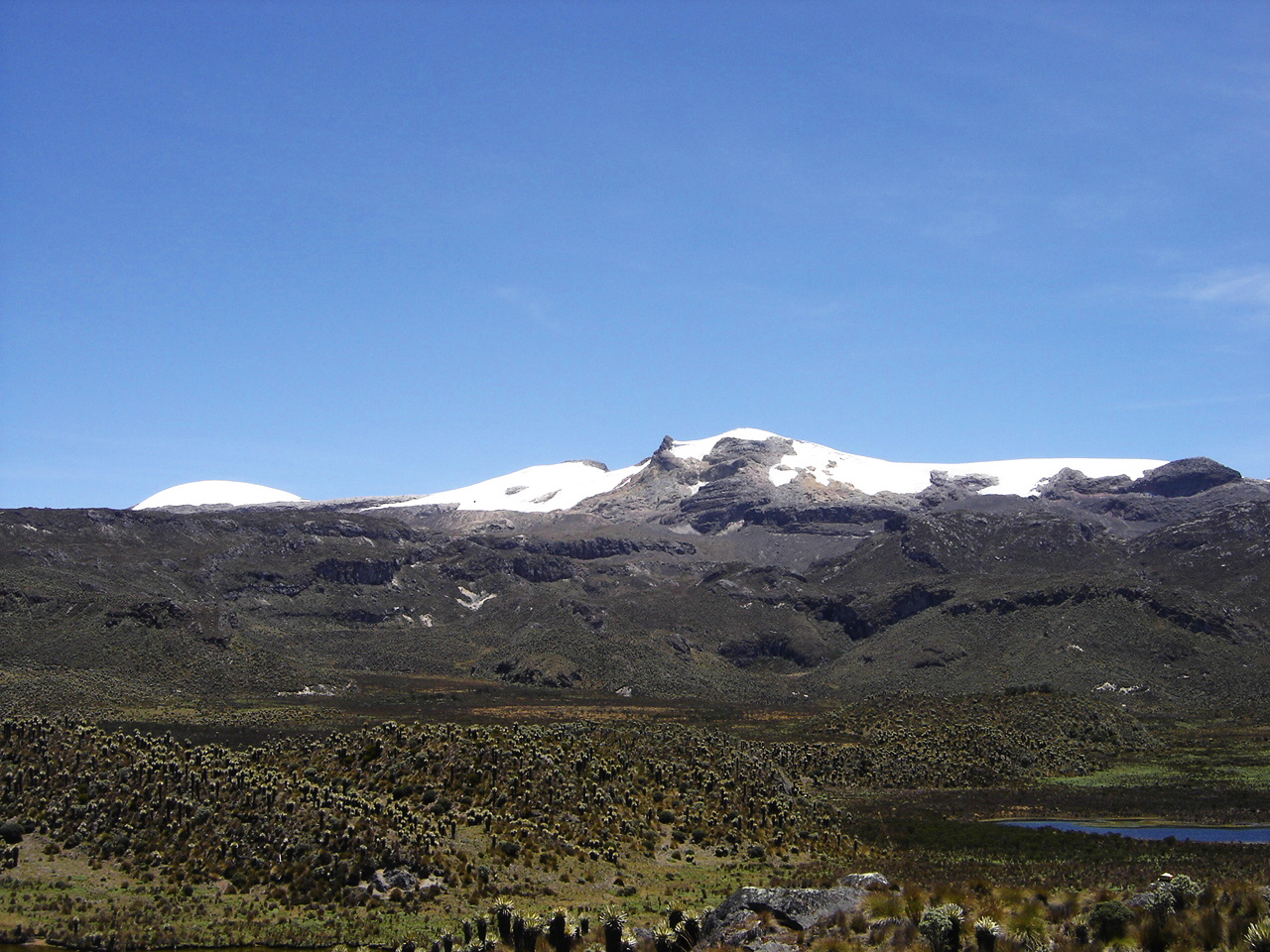
Colombia , Nevado Santa Isabel :
Weekly activity bulletin: Nevado Santa Isabel Volcano
Regarding the monitoring of the activity of the NEVADO SANTA ISABEL VOLCANO, the MINISTRY OF MINES AND ENERGY, through the COLOMBIAN GEOLOGICAL SERVICE (SGC), reports that:
During the week of April 16 to 22, 2024, the recording of seismic activity associated with the fracturing of rocks inside the volcanic edifice continued. This seismicity increased in the number of earthquakes recorded and in seismic energy released compared to the previous week. The earthquakes were located mainly on the southeastern flank of the volcanic structure, at distances of up to 6 km from its central part and at depths between 2 and 7 km. The highest magnitude of the week was 1.2, corresponding to the earthquake recorded on April 21 at 11:45 p.m., located approximately 5 km southeast of the volcano, at a depth of 4 km. This earthquake occurred during the seismic increase recorded between April 21 and 22 in the aforementioned sector.
Carbon dioxide (CO2) flux rates, which began to be measured since late last year toward the southwest of the volcano (area known as La Azufrera), remain within a stable range.
The other parameters measured and used for the diagnosis of volcanic activity did not present significant changes during the period evaluated.
The alert status for volcanic activity remains at: YELLOW ALERT: ACTIVE VOLCANO WITH CHANGES IN THE BEHAVIOR OF THE BASE LEVEL OF MONITORED PARAMETERS AND OTHER MANIFESTATIONS.
Source et photo : SGC
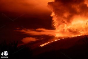
Hawaii , Kilauea :
Monday, April 29, 2024, 11:58 AM HST (Monday, April 29, 2024, 21:58 UTC)
19°25’16 » N 155°17’13 » W,
Summit Elevation 4091 ft (1247 m)
Current Volcano Alert Level: ADVISORY
Current Aviation Color Code: YELLOW
Activity Summary:
Kīlauea volcano is not erupting. The significant increase in seismicity beneath the upper East Rift Zone and caldera south of Halemaʻumaʻu that began in the early morning of April 27 is continuing and has intensified. Updates are being provided daily while the heightened state of unrest continues.
Summit and upper East Rift Zone Observations:
Earthquake activity increased sharply just after midnight on April 27 beneath the upper East Rift Zone (between Puhimau Crater and Hilina Pali road) and beneath Kīlauea caldera south of Halemaʻumaʻu. Earthquakes are occurring at depths of 1.5-2.5 km (1-1.5 miles) beneath the surface. Activity intensified yesterday and there have been over 360 earthquakes in the past 24 hours compared to 250 earthquakes in the previous 24 hours mostly beneath the upper East Rift Zone with fewer in the caldera south of Halemaʻumaʻu. In addition, the intensity of activity increased just after 11 p.m. on April 28, when several strong earthquakes including a magnitude 3.3 set off a swarm of earthquakes beneath the upper East Rift Zone that lasted for about 45 minutes. Activity returned to frequent small earthquakes less than magnitude 2 punctuated by occasional larger earthquakes with magnitudes between 2 and 3. The deeper earthquakes that were occurring 5-10 km (3-6 miles) directly beneath Kīlauea caldera over the past few weeks have ceased.
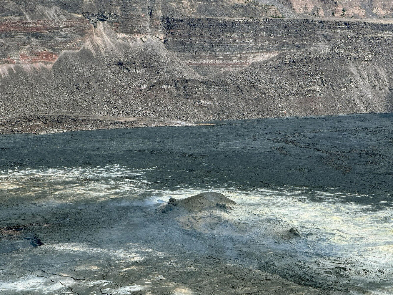
Kīlauea’s summit remains inflated. Overall ground deformation continues, with ongoing inflation of the summit and uplift south of the caldera. Tiltmeters near Uēkahuna and Sand Hill showed decreased rates of inflation and uplift on the evening of April 27 with the onset of a deflation-inflation (DI) event. The intense swarm of earthquakes recorded between 11 p.m. and midnight last night (April 28) coincided with increased inflation recorded on the Uēkahuna tiltmeter associated with the inflationary end of the DI event that began the previous day. Inflation at both tiltmeters returned to lower rates along with the seismicity just before midnight on April 28. Sulfur dioxide (SO2) gas emission rates remain low. An SO2 emission rate of approximately 52 tonnes per day was recorded on April 23.
Rift Zone Observations:
All seismic activity on the East Rift Zone is confined to the upper East Rift Zone, with no significant earthquakes or deformation occurring past the Mauna Ulu region. Seismicity in Kīlauea’s Southwest Rift Zone remains low overall. Measurements from continuous gas monitoring stations downwind of Puʻuʻōʻō in the middle East Rift Zone—the site of 1983–2018 eruptive activity—continue to be below detection limits for SO2, indicating that SO2 emissions Puʻuʻōʻō are negligible.
Source : HVO
Photo : USGS/ M. Patrick
Guatemala , Fuego :
Weather conditions: partly cloudy.
Wind: northeast
Precipitation: 34.6 mm.
Activity:
5 to 8 explosions per hour with low to moderate characteristics are recorded, generating columns of gas and ash 4,500 to 4,800 meters above sea level (14,763 – 15,748 feet), dispersing for 10 to 15 km in a West and South-West direction.
The explosions are accompanied by weak to moderate avalanches which reach the edge of the vegetation; low to moderate rumbling, mostly weak shock waves, sounds like that of a train locomotive, and incandescent pulses with heights of 100 to 200 meters above the crater. The above generates fine ash falls in towns located to the West and Southwest of the volcano, such as Panimaché I and II, Morelia, Santa Sofía, Porvenir, Sangre de Cristo, Palo Verde and others.
Source : Insivumeh
Photo : Diego Rizzo.
Costa Rica , Poas :
Daily report on the state of volcanoes. OVSICORI-UNA. Date: 2024-04-29. Updated at: 11:00:00.
Latitude: 10.2
Longitude: -84,233
Altitude: 2,687 meters above sea level
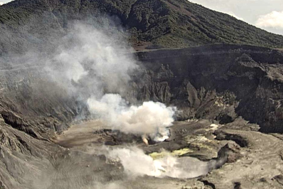
Activity observed:
Since midday yesterday, a slight emission of ash has been observed from vent C. The emission was more intense yesterday afternoon with columns reaching several hundred meters. Today the emission is lower with plumes poor in ash and at low altitude (<150m). Seismicity demonstrates tremors of variable frequency and amplitude with frequent small LP-type earthquakes. Yesterday afternoon, the MultiGAS station recorded a concentration of 42 ppm of SO2 (very high), and a CO2/SO2 ratio of 0.15 (very low). The SO2 concentration at the lookout peaked at 2.9 ppm this morning.
Environmental conditions: Mostly cloudy;
Wind: South-West
Activity Level: Warning (2)
Source et photo : ovsicori