May 01 , 2024.
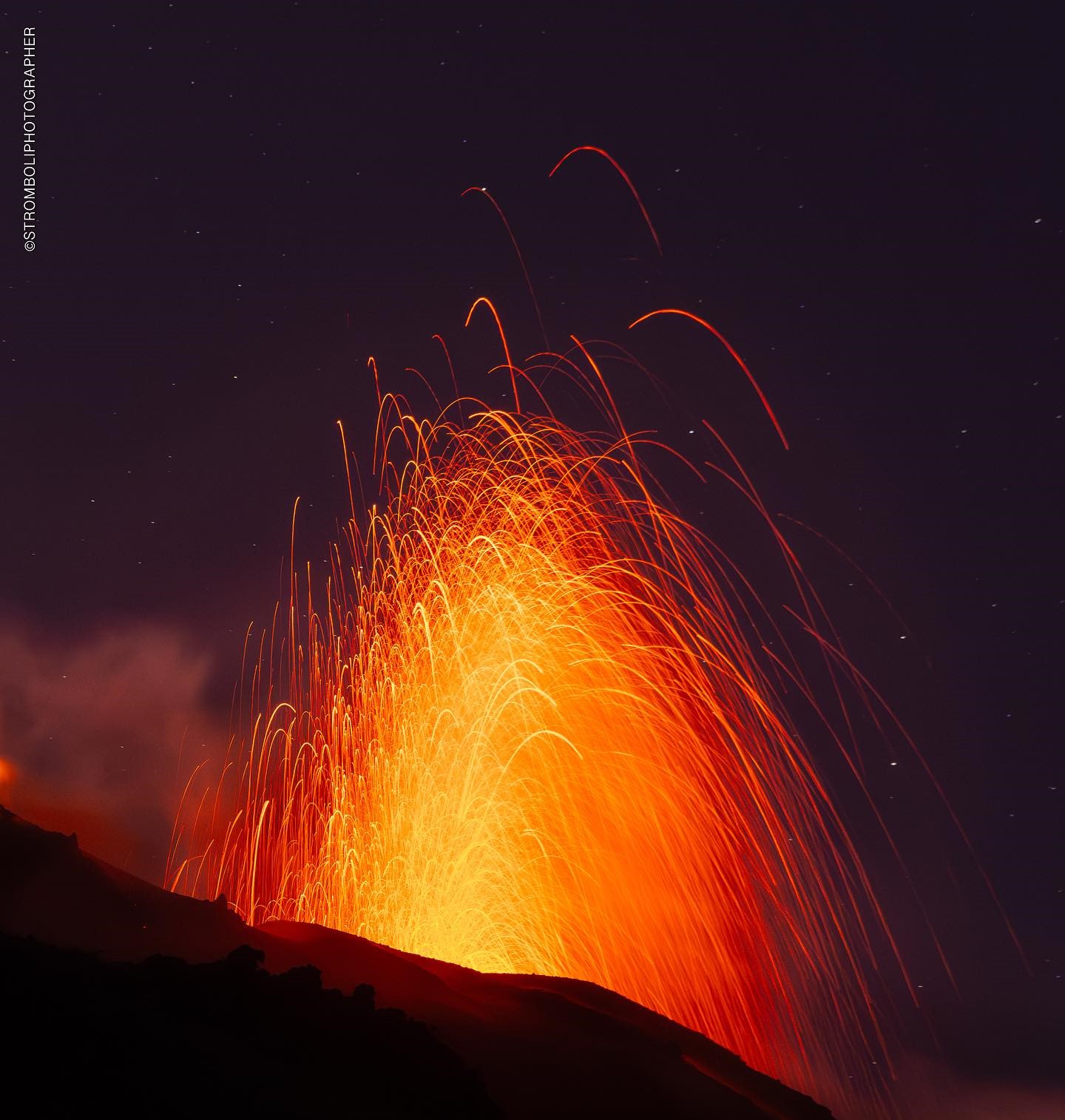
Italy , Stromboli :
WEEKLY BULLETIN, from April 22, 2024 to April 28, 2024. (issue date April 30, 2024)
SUMMARY STATEMENT OF ACTIVITY
In light of the monitoring data, it appears:
1) VOLCANOLOGICAL OBSERVATIONS: During this period, normal Strombolian activity with projection activity was observed. The total hourly frequency varied between medium values (14 events/h) and high values (20 events/h). The intensity of the explosions was mainly low and medium in the North and South-Central crater areas.
2) SISMOLOGY: The monitored seismological parameters do not show significant variations.
3) GROUND DEFORMATIONS: The ground deformation monitoring networks did not show significant variations.
4) GEOCHEMISTRY: SO2 flux at medium level
The CO2 flux in the summit zone is at average values.
The C/S ratio in the plume is at average values
Helium Isotope Ratio in Thermal Aquifer: There are no updates.
CO2 flow in Mofeta in the San Bartolo area: medium-low values.
CO2 flux in Scari: stable values at average levels.
5) SATELLITE OBSERVATIONS: Thermal activity observed by satellite was generally low level with some rare and isolated thermal anomalies of moderate level.
VOLCANOLOGICAL OBSERVATIONS
In the observed period, the eruptive activity of Stromboli was characterized through the analysis of images recorded by the INGV-OE surveillance cameras located at Pizzo (SPT), at altitude 190m (SCT-SCV) and at Punta dei Corvi (SPCT. The explosive activity was mainly produced by two eruptive vents located in the North area of the crater and by three vents located in the South Central area. At 12:51 UTC on April 22, the power system failure caused was repaired and surveillance cameras resumed capturing images.
Observations of explosive activity captured by surveillance cameras
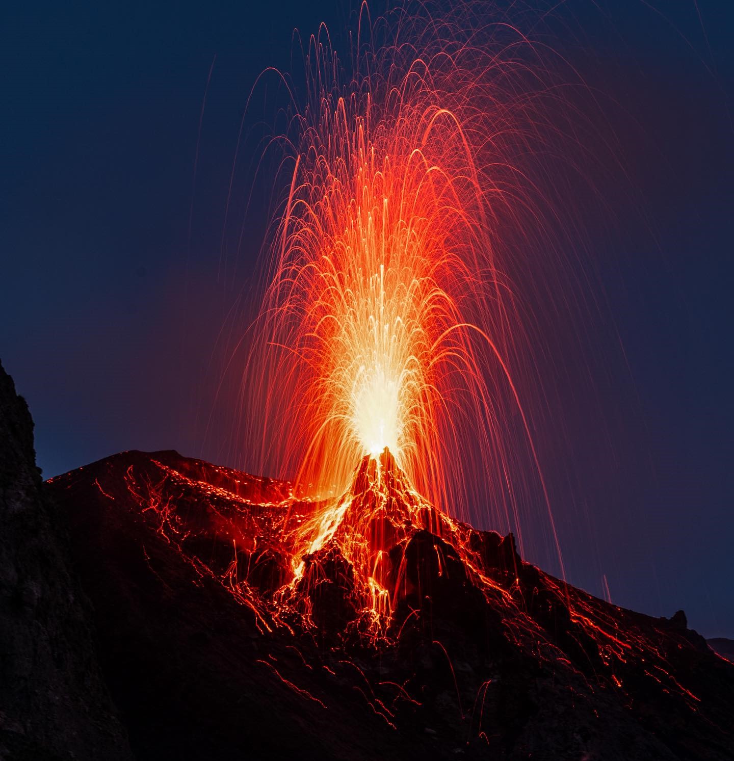
In the North crater area (N), with two vents located in sector N1, explosive activity was observed which was low (less than 80 m in height) to medium (less than 150 m in height) while in the sector S2, activity was observed to be absent. One of the two vents was located on a hornito which was the site of intense splashing activity on April 27-28. The products emitted in the eruption were mainly coarse materials (bombs and lapilli). The average frequency of explosions varied between 5 and 11 events/h.
In the Central-South (CS) zone, sectors C and S1 did not show significant activity, while in sector S2, with two emission points, the explosions varied in intensity from low (less than 80 m high) to high (greater than 150 m) emitting coarse materials. The average frequency of explosions varied from 7 to 9 events/h.
Field observations following inspections on April 26 and 28, 2024.
On April 26 and 28, inspections were carried out in the summit area (Pizzo) in order to characterize the morpho-structural structure of the crater terrace and the explosive activity.
In the northern area of the crater, sector N1 showed splash activity coming from a hornito and a vent located in a position overlooking the Sciara del Fuoco, interrupted by explosions of mainly coarse materials mixed with ash with production occasional gas rings. The intensity of the explosions ranged from low to medium, while the frequency was medium. No activity was observed in sector N2; there were two vents with edges showing fumaroles.
In the South Central crater area of sector S1 there was a stocky hornito with only outgassing activity, while in sector S2 there was a large circular cone with explosive activity emitting mainly coarse materials mixed with ashes. The intensity and frequency of the explosions were medium-low. On the northeastern flank of sector S2, the presence of a degassing vent was noted.
On April 28, a clear growth of hornito in the N1 sector was observed, with vigorous and almost continuous projection activity.
Source : INGV
Photos : Stromboli stati d’animo / Sebastiano Cannavo.
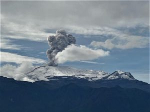
Philippines , Kanlaon :
KANLAON VOLCANO ADVISORY , 30 April 2024 , 3:30 PM
This is a notice of increased volcanic SO2 gas flux at Kanlaon Volcano.
Volcanic sulfur dioxide (SO2) gas emission from the summit crater of Kanlaon based on campaign Flyspec measurements today, 30 April 2024, averaged 2,707 tonnes/day. This is the second highest emission recorded this year; a maximum of 3,098 tonnes/day of SO2 was recorded on 19 January 2024. Kanlaon has been degassing increased concentrations of volcanic SO2 at an average rate of 1,300 tonnes/day for the year. In addition, although volcanic earthquake activity remains at a baseline average of 3 events/day, episodes of increased seismicity have occurred several times this year. Ground deformation data from continuous GPS and electronic tilt measurements have been recording medium-term inflation of the Kanlaon edifice since March 2022 and a shorter-term inflation of the eastern flank since 2023, indicating slow pressurization within the volcano. The overall monitoring parameters indicate that degassing of deep magma may be driving increased hydrothermal activity beneath the edifice, causing increased volcanic gas emission, swelling of the edifice and occasional volcanic earthquake activity.
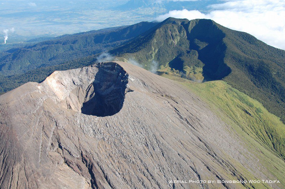
The public is reminded that Alert Level 1 prevails over Kanlaon. The public and local government units are strongly advised to be vigilant and refrain entry into the four (4) kilometer Permanent Danger Zone (PDZ) due to increased chances of sudden and hazardous phreatic eruptions occurring without warning. Civil aviation authorities must also advise pilots to avoid flying close to the volcano’s summit as ejecta from any sudden phreatic eruption can be hazardous to aircraft. DOST-PHIVOLCS is closely monitoring Kanlaon Volcano’s activity and any new development will be relayed to all concerned.
Source : Dost-Phivolcs
Photo : Bong Bong Woo Tadifa.
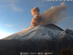
Indonesia , Ibu :
Press release on the activity of the Ibu Volcano from April 30, 2024
Mount Ibu is a stratovolcano which rises to an altitude of 1,340 m. Geographically, Mount Ibu is located at the coordinate position 1°29′ N and 127°38′ E and administratively, it is included in the area of Ibu District, West Halmahera Regency, North Maluku Province. Mount Ibu is observed visually and instrumentally from the Volcano Observation Post (PGA) located in Gam Ici village, Ibu district, West Halmahera regency, North Moluccas.
Since 1999 until today, Mount Ibu has experienced continuous eruptions. The current state of Mount Ibu is the formation of a lava dome within the crater with significant growth that has overtaken the crater walls, resulting in lava avalanches to the North and Northwest.
The latest developments in G. Ibu’s activity until April 30, 2024 are as follows:
Visual observations:
On April 24, 2024 at 11:53 WIT, an eruption occurred with an 800 meter high ash column facing west, a loud roar could be heard reaching the PGA Ibu post. At 2:58 p.m. WIT, an eruption occurred with a high level ash column (1,500 meters), direction of the eruption column to the West, the roar could be heard at the PGA Ibu station.

On April 26, 2024 at 7:19 p.m. WIT, an eruption occurred with a column height observed at approximately 2,000 m above the peak, gray in color with thick intensity oriented towards the Southwest and West. An incandescence was observed ± 700 m from the summit and the sound of an explosion accompanied by a loud roar was heard at the PGA Ibu station, ashes fell on residential areas to the West and South-West.
On April 27, 2024 at 09:15 WIT, an eruption occurred with an ash column with a height of 1,200 meters, the ash column oriented to the West and Southwest.
On April 28, 2024 at 00:37 WIT, an eruption occurred with an eruption column height of approximately 3,500 meters, the direction of the eruption column was westward, lightning was observed in the eruption column, the sound of rumbling and roaring was heard all the way to PGA Ibu Post. Ash rains fell on residential areas west of Mount Ibu.
On April 29, 2024 at 9:37 p.m. WIT, an eruption occurred with the height of the eruptive column observed at ±1,000 m above the peak, gray in color with thick intensity oriented towards the West and Northwest . During this eruption, incandescent projections were observed at around 500 m and incandescent lava was ejected at a distance of around 500m towards the West, North-West and South-West, during this eruption a thud accompanied by rumbling was also heard all the way to the PGA Post.
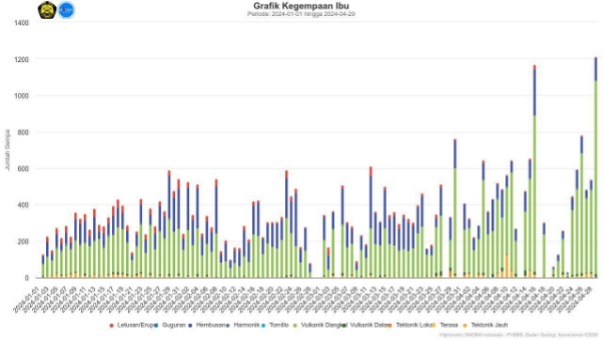
Observations of the seismicity of Mount Ibu show high seismicity. Seismicity records are dominated by eruption earthquakes, emissions earthquakes, and volcanic tremors. Just before the eruption, a series of fairly intense shallow volcanic earthquakes and continuous tremors were recorded.
Due to the frequency of ashfall in settlements around the slopes of the G. People who carry out activities outside the home are advised to wear protection for the nose, mouth (mask) and eyes (goggles). ).
Based on visual and instrumental monitoring until April 30, 2024, the Geological Agency stated that the activity level of G. ibu is still high, however, there has been no significant change in the threat of danger, so the activity level is always at level II. (WASPADA). At Level II Activity Level (WASPADA): Communities around Mount Ibu and visitors/tourists should remain vigilant and not enter the area within a 3.5 km radius from the center of the active crater of the Mount Ibu.
The activity level of G. Ibu will be reviewed if there are significant visual and seismic changes.
Source et photos : PVMBG
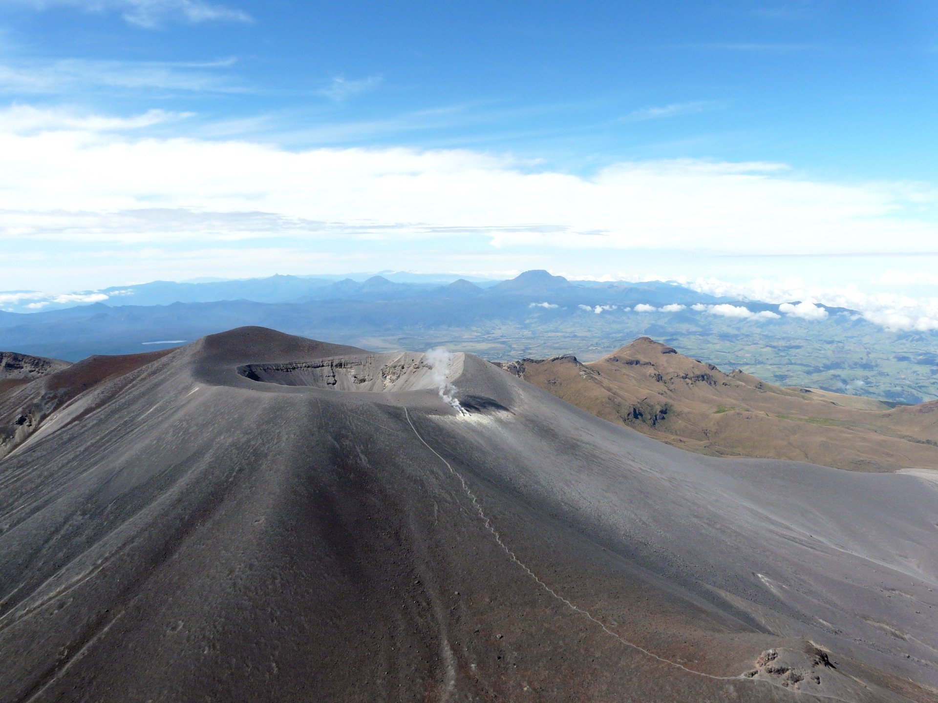
Colombia , Puracé – Puracé – Los Coconucos Volcanic Range :
Popayán, April 30, 2024, 10:15 a.m.
From the monitoring of the activity of the PURACE VOLCANO, LOS COCONUCOS VOLCANIC CHAIN, the MINISTRY OF MINES AND ENERGY, through the COLOMBIAN GEOLOGICAL SERVICE (SGC), reports that:
Over the past 16 hours, there has been an increase in the recurrence of seismic events associated with rock fracturing and fluid movement within the volcano. These earthquakes, although of low energy, were located under the building of the Puracé volcano, at depths between 0 and 5 km. This increase in seismicity indicates that the volcano continues to show changes in its activity, which have been occurring gradually for several months.
The alert status of the volcano remains YELLOW: Active volcano with changes in the behavior of the base level of monitored parameters and other manifestations.
Weekly activity bulletin: Puracé Volcano – Los Coconucos volcanic chain
From the monitoring of the activity of the PURACE VOLCANO, LOS COCONUCOS VOLCANIC CHAIN, the MINISTRY OF MINES AND ENERGY, through the COLOMBIAN GEOLOGICAL SERVICE (SGC), reports that:
In the week of April 23 to 29, 2024, and compared to the levels recorded over the last three months, seismic activity presented an increase in the recurrence of events associated with fluid dynamics in volcanic conduits. This increase occurred mainly in volcanic tremor (TR type) and long period (LP type) events, which until now were of low energy. On the other hand, the seismicity associated with the fracturing of rocks (VT type) was localized both under the Puracé volcano, as well as under the Piocollo and Curiquinga volcanoes, at depths between 1 and 5 km with low magnitudes.
Since yesterday afternoon, April 29, and until the time of publication of this bulletin, there has been an increase in the number of VT and LP type events, the characteristics of which have been described in the bulletin. extraordinary above.
Likewise, the slow deformation process that began in April 2022 between the Puracé and Curiquinga volcanoes continues to be recorded. The concentration of carbon dioxide (CO2) maintains a
trend above known reference values for the Puracé volcano and the increase in the flux of sulfur dioxide (SO2) detected in previous weeks continues to be observed.
Images obtained using installed cameras show that significant degassing of the volcanic system continues.
Other parameters measured for the assessment of volcanic activity showed no notable changes during the assessed period.
The SGC calls on people who visit the Puracé National Natural Park not to approach the upper part of the Puracé and Curiquinga volcanoes, given that the increase in gas emissions into the atmosphere can cause damage to health.
The alert status for volcanic activity remains at: YELLOW ALERT: ACTIVE VOLCANO WITH CHANGES IN THE BEHAVIOR OF THE BASE LEVEL OF MONITORED PARAMETERS AND OTHER MANIFESTATIONS.
Source et photo: SGC
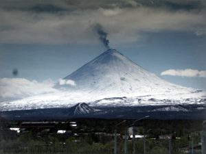
Hawaii , Kilauea :
Tuesday, April 30, 2024, 9:35 AM HST (Tuesday, April 30, 2024, 19:35 UTC)
19°25’16 » N 155°17’13 » W,
Summit Elevation 4091 ft (1247 m)
Current Volcano Alert Level: ADVISORY
Current Aviation Color Code: YELLOW
Activity Summary:
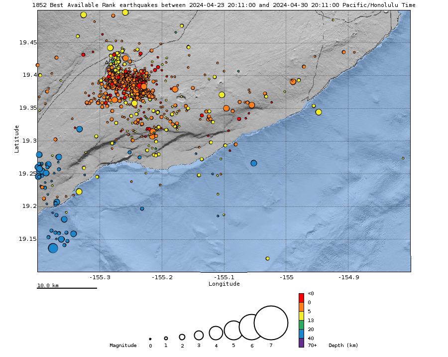
Kīlauea volcano is not erupting. The significant increase in seismicity beneath the upper East Rift Zone and caldera south of Halemaʻumaʻu that began on April 27 is continuing. Updates are being provided daily while the heightened state of unrest continues.
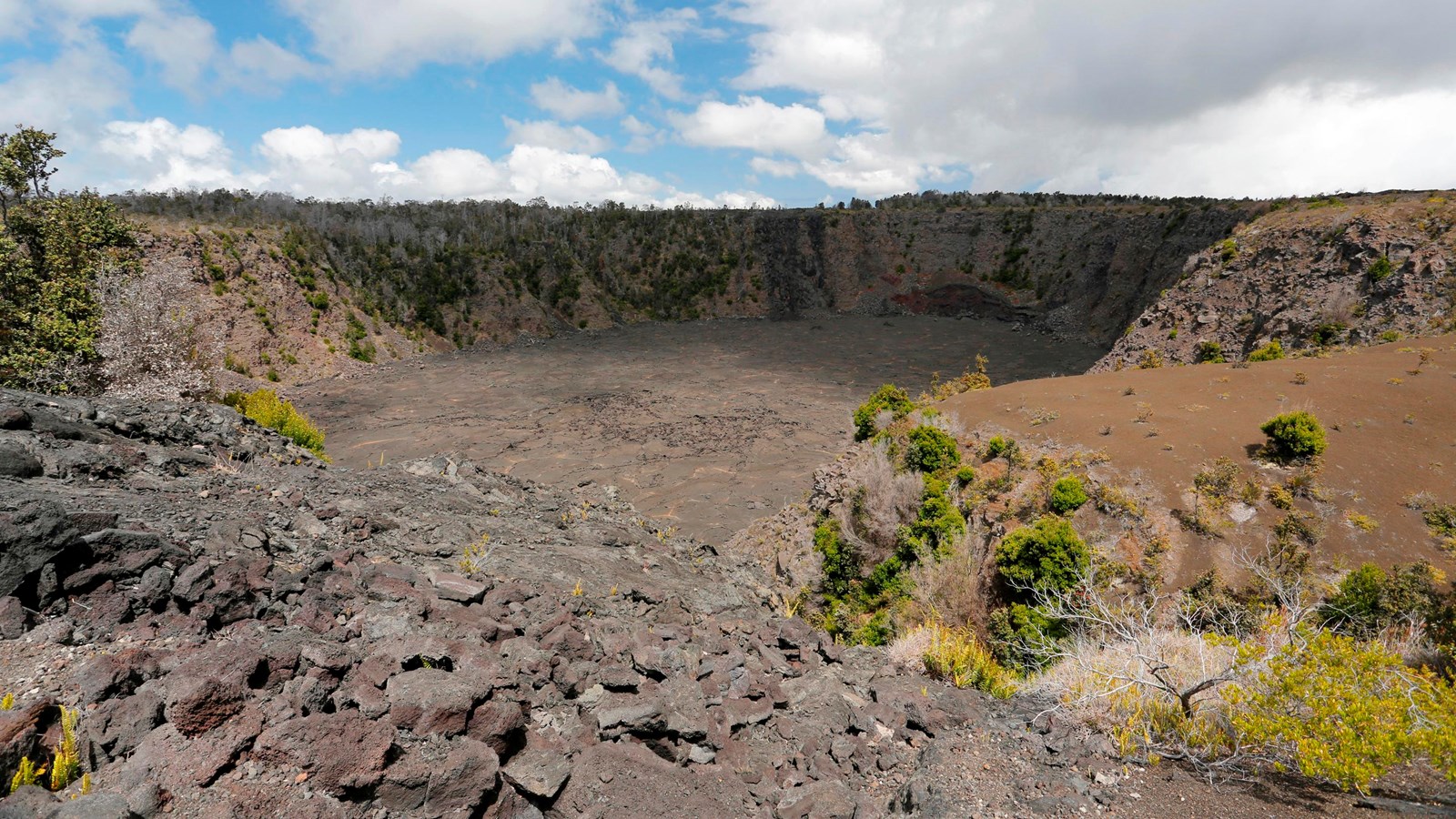
Meaning « cave of the adzes », this collapse crater rests on the fault that surrounds the summit of Kīlauea. Keanakākoʻi arose during a time of great upheaval and collapse at Kīlauea’s summit in the 1500s to 1700s.
Summit and upper East Rift Zone Observations:
Earthquake activity increased sharply just after midnight on April 27 beneath the upper East Rift Zone and beneath Kīlauea caldera south of Halemaʻumaʻu. Earthquake locations beneath the upper Easth Rift Zone continue to be focused primarily between Puhimau Crater and Hilina Pali Road, with slight expansion northwest toward Keanakākoʻi Crater and southeast toward Pauahi Crater over the past 24 hours. Earthquakes are occurring at depths of 1.5-2.5 km (1-1.5 miles) beneath the surface. There were over 360 earthquakes in the past 24 hours, about the same number as the previous 24 hours, located mostly beneath the upper East Rift Zone with fewer in the caldera south of Halemaʻumaʻu. Unlike the previous 24 hours, no earthquakes greater than magnitude-3 were observed in the past 24 hours. Most earthquakes were less than magnitude-2 punctuated by occasional larger earthquakes with magnitudes between 2 and 3. Activity is ongoing at a rate of about 15 earthquakes per hour.
Accelerated rates of ground deformation continue with ongoing overall inflation of the summit and uplift south of the caldera. Tiltmeters near Uēkahuna and Sand Hill showed increased rates of inflation and uplift yesterday until about 6:00 PM when rates decreased slightly with the onset of a deflation-inflation (DI) event.
Sulfur dioxide (SO2) gas emission rates remain low. An SO2 emission rate of approximately 52 tonnes per day was recorded on April 23.
Rift Zone Observations:
All seismic activity on the East Rift Zone is confined to the upper East Rift Zone, with no significant earthquakes or deformation occurring past the Mauna Ulu region. Seismicity in Kīlauea’s Southwest Rift Zone remains low overall. Measurements from continuous gas monitoring stations downwind of Puʻuʻōʻō in the middle East Rift Zone—the site of 1983–2018 eruptive activity—continue to be below detection limits for SO2, indicating that SO2 emissions Puʻuʻōʻō are negligible.
Analysis:
At this time, it is not possible to say with certainty if this increase in activity will lead to an eruption in the near future – or simply remain confined below ground. However, the gradual strengthening of seismic swarms suggests that an eruption in Kīlauea’s summit region or beneath the upper East Rift Zone, within Hawai‘i Volcanoes National Park, is one potential outcome.
Source : HVO
Photo : M. Szoenyi , HVO.