
April 06 , 2022.
Italy , Vulcano :
WEEKLY BULLETIN, from March 28, 2022 to April 03, 2022. (issue date April 05, 2022)
ACTIVITY STATUS SUMMARY
In the light of the surveillance data, it is highlighted:
1) Temperature of the crater fumaroles: The temperature data recorded on the rim of the crater show stable values at high levels.
2) CO2 flux in the crater area: There are no updates available for the CO2 flux in the crater area. The latest measurements available (26.03.2022) were at high values (around 14000 g/m2/day).
3) SO2 flux in the crater area: SO2 flux at a medium-high level
4) Geochemistry of fumarolic gases: no update is available
5) CO2 fluxes at the base of the La Fossa cone and in the Vulcano Porto area: The CO2 fluxes recorded in the C. Sicilia and P4max sites show a slight downward trend, but remain at medium-high values ; in the Faraglione site there are values close to the background.
6) Geochemistry of thermal aquifers: The temperature measured in the Camping Sicilia well is at high and stable values. The electrical conductivity shows low values.
The level values measured in the Bambara well show a small fluctuation. Conductivity values remain constant at medium-high levels.
7) Local seismicity: low occurrence rate of local events.
8) Regional seismicity: Modest fracturing seismicity associated with earthquakes with Ml >= 1.0.
9) Deformations – GNSS: The network of permanent GNSS stations has not recorded any significant changes.
10) Deformations – Inclinometry: The inclinometric network has not recorded any significant changes.
11) Other remarks: Mobile GNSS: No significant variation is visible during the period considered.
Gravimetry: During the period considered, no significant change was recorded.
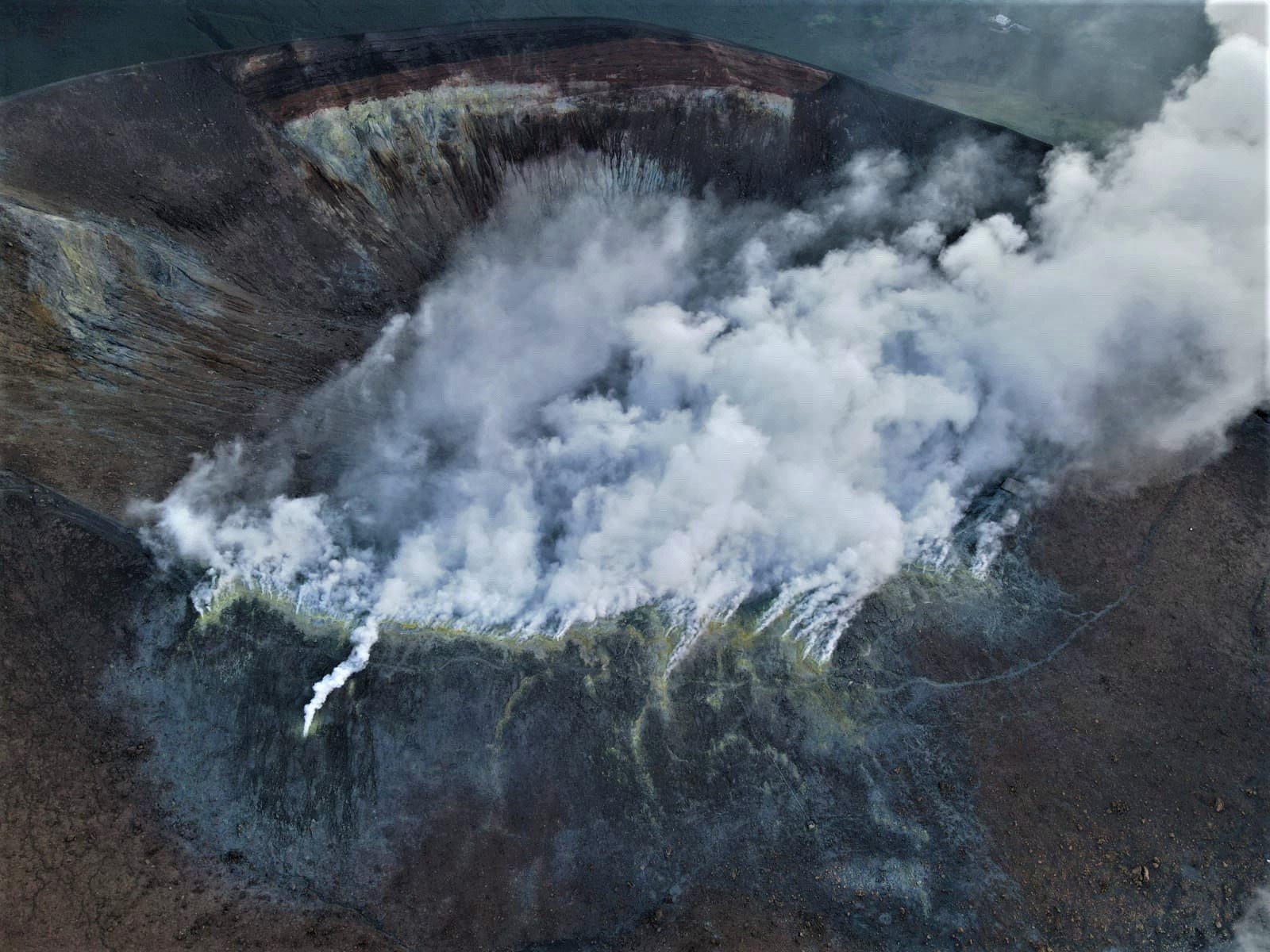
CRATER FUMAROLES TEMPERATURE.
The reference sensor for the maximum temperature has stable values (T3: 382-387°C), with a weekly average of 385°C. The nearby sensor (T2) last week showed a slight increase in emission temperatures, the weekly average increased from 368°C (23-30 March) to 374°C (30 March – 5 April). Locally, the sensor placed in the fumarole on the inner side showed oscillations between 111 and 26°C, but the instability of the measurements suggests the need for maintenance.
REGIONAL SEISMICITY
In the week between March 28 and April 3, 6 events with local magnitudes greater than or equal to 1 were recorded in the Vulcano Island area. In particular, the event that occurred on March 31, 2022 at 06:21 UTC, of ML = 1.1, is located about 5.6 km northwest of Porto di Ponente di Vulcano at a depth of about 3 km . The 5 other events (ML between 1.1 and 1.9) are all located southeast of Porto di Ponente di Vulcano at a depth of between 6 and 9 km .
Source : INGV.
Photo : INGV-Roma1
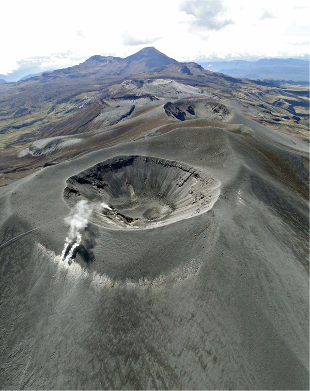
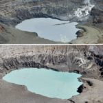
Colombia , Puracé :
Weekly bulletin of the activity of the Puracé volcano – Los Coconucos volcanic chain
The activity level of the volcano continues at the yellow activity level or (III): changes in the behavior of volcanic activity.
From the analysis and evaluation of the information obtained through the monitoring network of the Puracé volcano – Los Coconucos volcanic chain, during the week of March 29 to April 4, 2022, the COLOMBIAN GEOLOGICAL SERVICE – Volcanological and Seismological Observatory de Popayán informs that:
• During the evaluated period, the levels of seismic activity associated with rock fracturing (VT type) and fluid dynamics (LP type – Long Period and TR – Volcanic Tremor) remained permanently high. VT-type seismicity continued to occur mainly 800 m southeast of the crater of the Puracé volcano. Other eruptive centers of the Los Coconucos volcanic chain are also found at this site, highlighting the activity of the Curiquinga volcano (Figure 1); It should be noted that this activity was characterized by the presentation of earthquakes of low magnitude and with depths of 2 km on average.
• It is emphasized that since the beginning of today until the time of publication of this communication, the seismicity of the fluids has shown a progressive increase in its recurrence.
• The geodetic network GNSS (Global Navigation Satellite System) and the processing DInSAR (Differential Interferometry by Synthetic Aperture Radar) used to follow the deformation of the volcanic soil recorded two important processes: one associated with an inflationary process of millimeter order, and the other with a co-seismic deformation process following the magnitude 3.3 ML VT event of March 29, 2022 at 12:14 p.m. (local time). These processes continue to be recorded as of the date of publication of this bulletin.
• An increase in sulfur dioxide and carbon dioxide (SO2, CO2) gas emissions has been detected, both instrumentally and by direct sampling. Similarly, the fumarole located on the northern flank of the Puracé volcano showed changes in its external dynamics (increase in the pressure of the expelled gas and strong sulfur odors). On the other hand, the emission of SO2 was corroborated by the processing of satellite images, as well as the formation of two cracks about 40 m long, through which an emission of volcanic ash occurred on March 29. This was confirmed by technicians in the area of influence of the volcano, who were carrying out territorial control activities in the volcanic chain.
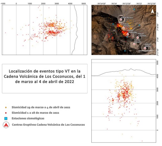
Figure 1. Location of fracture events in the Los Coconucos volcanic chain, between the Puracé and Curiquinga volcanoes.
Therefore, it is concluded that a significant increase in volcanic activity continues to be recorded, in accordance with the behavior expected at activity level III (yellow level), which could evolve towards states of greater activity. The Colombian Geological Service continues to monitor the evolution of the volcanic phenomenon and will report any changes that may occur in due course.
Source et photos : SERVICE GEOLOGIQUE COLOMBIEN .
Italy , Stromboli :
WEEKLY BULLETIN, from March 28, 2022 to April 03, 2022. (issue date April 05, 2022)
ACTIVITY STATUS SUMMARY.
In the light of the surveillance data, it is highlighted:
1) VOLCANOLOGICAL OBSERVATIONS: During this period, normal explosive activity of the Strombolian type was observed with projection activity in the North zone. The total hourly frequency of explosions fluctuated between medium (12 events / h) and medium-high (18 events / h) values. The intensity of the explosions was mainly medium and low in the area of the North crater and low in the area of the Center-South crater.
2) SEISMOLOGY: The seismological parameters monitored do not show any significant variations.

3) SOIL DEFORMATIONS: The island’s soil deformation monitoring networks did not show any significant variation.
4) GEOCHEMISTRY: SO2 flux at an average level
CO2 fluxes in the crater area remain at medium-high values.
Due to technical issues, there are no updates on the C/S ratio in the plume.
There are no updates on the isotope ratio of helium in groundwater.
5) SATELLITE OBSERVATIONS: The thermal activity observed by satellite was at a low level.
VOLCANOLOGICAL OBSERVATIONS
During the observation period, the eruptive activity of Stromboli was characterized through the analysis of images recorded by the INGV-OE surveillance cameras (altitude 190 m, Punta Corvi, altitude 400 m and Pizzo ). The explosive activity was mainly produced by 5 (five) eruptive vents located in the North crater area and 2 (two) eruptive vents located in the Center-South crater area. All the mouths are located inside the depression which occupies the terrace of the crater.
Due to the unfavorable weather conditions of April 1, 2022, the visibility of the crater terrace was insufficient for a correct description of the eruptive activity.
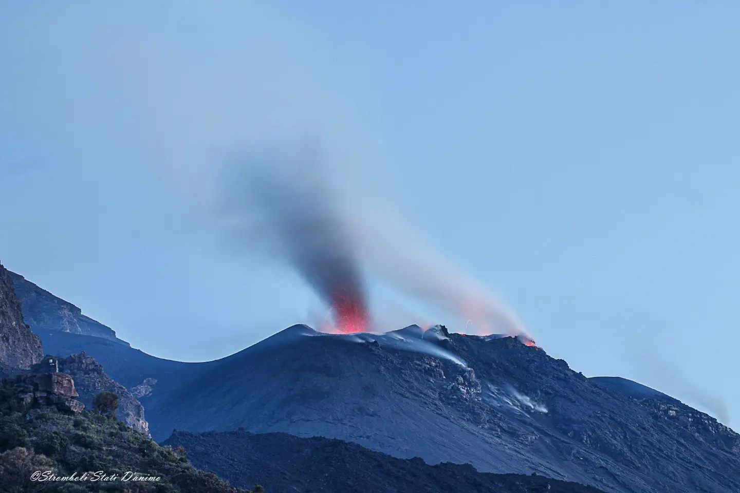
Sector N1 located in the area of the North crater produced explosions of variable intensity, from low (less than 80 m high) to medium (less than 150 m high) emitting coarse materials (lapilli and bombs). Sector N2, with four emission points, showed explosive activity of medium-low intensity (less than 120 m in height) emitting coarse materials with intense projection activity during short intervals on March 30. The average frequency of explosions varied from 9 to 13 events/h.
In the Center-South zone, sectors C and S1 did not show significant explosive activity. Sector S2, with two emission points, had low intensity explosions (the products of the explosions did not exceed 80 m in height) emitting coarse materials. The frequency of the explosions varied between 1 and 7 events/h.
Source : INGV.
Photos : INGV , Stromboli stati d’animo
Indonesia , Semeru :
VOLCANO OBSERVATORY NOTICE FOR AVIATION – VONA
Issued : April 06 , 2022
Volcano : Semeru (263300)
Current Aviation Colour Code : ORANGE
Previous Aviation Colour Code : orange
Source : Semeru Volcano Observatory
Notice Number : 2022SMR95
Volcano Location : S 08 deg 06 min 29 sec E 112 deg 55 min 12 sec
Area : East java, Indonesia
Summit Elevation : 11763 FT (3676 M)
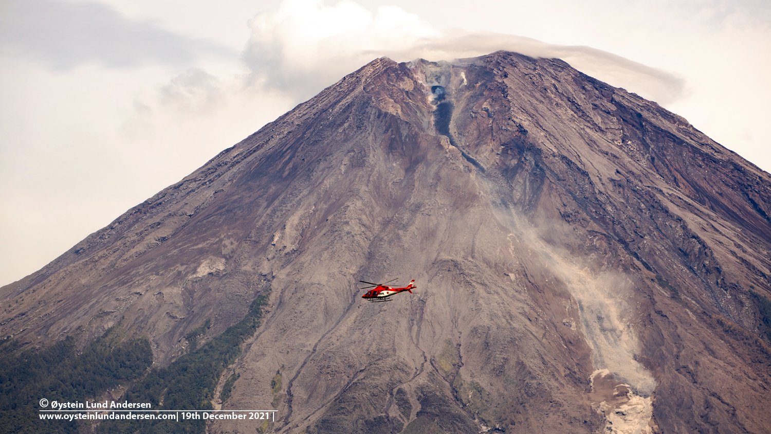
Volcanic Activity Summary :
Eruption with volcanic ash cloud at 00h38 UTC (07h38 local)
Volcanic Cloud Height :
Best estimate of ash-cloud top is around 14003 FT (4376 M) above sea level, may be higher than what can be observed clearly. Source of height data: ground observer.
Other Volcanic Cloud Information :
Ash-cloud moving to north
Source : Magma Indonésie .
Photo : Oystein Lund Andersen .
Iceland , Reykjanes Peninsula :
Just under 630 earthquakes were detected by the SIL-seismic network last week, which is a increase from previus week where 430 earthquakes were located. Most active area was the Reykjanes peninsula, about 150 earthquakes measured there in a short term seismic swarm in the eastern part of Mt. Sýrlingafell, northnortheast of the town of Grindavík.
There two earthquakes larger than M3.0 were measured one being the largest earthquake of the week of M3.3 on April 3rd at 14:19. It was felt in Grindavík. Many earthquakes were mesured around Iceland this week, one of which was of M2.7 by the slope of the continental shelf east of Iceland, about 110km from the coast.
Source et photo : Vedur is.
Azores , São Jorge :
São Jorge, 05 April 2022, 23:00.
Earthquakes felt on the island of São Jorge (Situation update, April 05, 2022, 22:00)
The Azores Seismo-Volcanic Information and Monitoring Center (CIVISA) informs that the seismic activity recorded since 4:05 p.m. (local time = UTC-1) on March 19 in the central part of the island of São Jorge, more precisely along a line in a West-North-West/East-South-East direction, in an area between Velas and Fajã do Ouvidor, remains above normal. The most energetic earthquake occurred on March 29 at 9:56 p.m. (local time = UTC) and had a magnitude of 3.8 (Richter). So far, about 228 earthquakes felt by the population have been identified.
From 10 a.m. to 10 p.m. on April 5, two earthquakes were felt:
an event of M 2.2, at 12:38 p.m., located 1 km north of Santo Amaro, and felt in the localities of Velas, Santo Amaro and Rosais.
an event of M 2.1, at 9:23 p.m., located 3 km east of Beira, and felt in the localities of Velas, Santo Amaro.
Press release SRPCBA – State of the seismo-volcanic crisis on the island of São Jorge
The president of the Regional Civil Protection and Fire Service of the Azores (SRPCBA) said today that the work of reconnaissance and evaluation of various points of São Jorge continues, following the seismo-volcanic crisis recorded on the island since March 19. .
« Today, the images collected yesterday in the Rosais will be analyzed », to see if « there is any fragility, any risk in terms of slopes or possible collapses which endanger passers-by », explained Eduardo Faria.
As part of the work that was carried out, « possible ports that could be used for evacuation [by] sea » were also recognized and « we were also able to understand what the reaction times are, in case it is necessary to reinforce the teams that are in the reception and sorting stations”.
Source : CIVISA. SRPCBA
Photo : GEVolcans


No comment yet, add your voice below!