
January 12 , 2022.
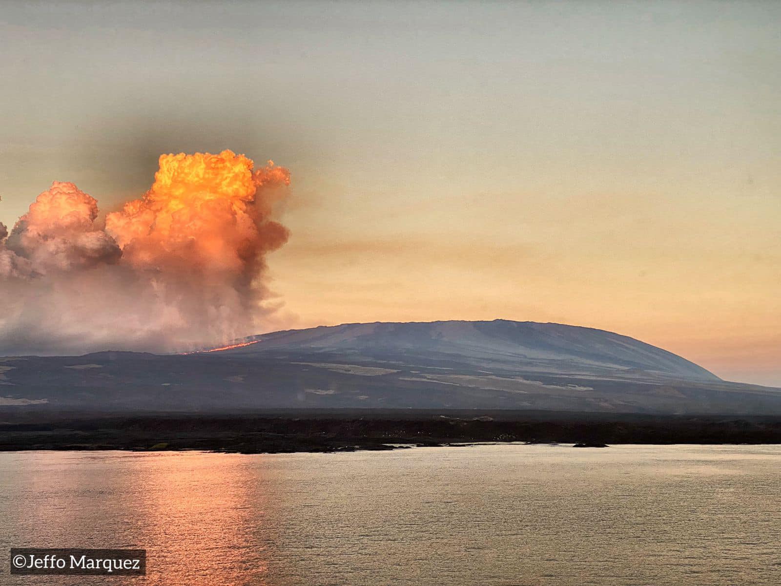
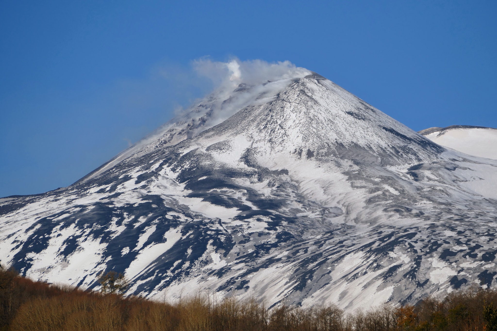
Ecuador / Galapagos / Isabella , Wolf :
The activity of the Wolf volcano is maintained
Minister Gustavo Manrique flew over the region of the Wolf volcano on Isabela Island, confirming that the eruptive activity was continuing. The lava flows are located less than five kilometers from the coast, on the east side of the island.
« The direction taken by the lava flows and the general development of the eruption allows us to stress that the pink iguana population remains safe, » said Minister Manrique.
The magma has traveled approximately 15 kilometers since the start of the activity, moved through ancient lava fields from previous eruptions and the vegetation of the arid zone of the Galapagos, where forests of rosewood, chala, rosemary and other species of native and endemic flora predominate.

“There is very little iconic fauna in the eruption impact area; however, species have evolved with these natural processes that are part of the normal dynamics of Galapagos ecosystems. The populations of iguanas, turtles and birds are found to the north of the volcano, where historically less volcanic activity has been recorded, ”added Danny Rueda, director of the Galapagos National Park.
Volcanic eruptions are natural processes that gave birth to the Galapagos Islands. The Ministry of Environment, Water and Ecological Transition continues to monitor this phenomenon to document the changes that may occur in the ecosystem.
VOLCAN WOLF DAILY ACTIVITY REPORT, Wednesday January 12, 2022.
From: January 10, 2022, 11:00 a.m. To: January 11, 2022, 11:00 a.m.
Surface activity level: very high
Surface trend: Descending
Internal: high
Internal tendency: Descending
Seismicity: The seismicity was carried out with data from the FER1 station
Volcano-Tectonics (VT) 1
Tremors of emissions (TREMI) 1
Emission / ash column:
Gas emissions from satellite images are moving towards the southwest.
Other monitoring parameters:
The MIROVA satellite system reported 2 extreme thermal alerts (16,030 and 18,190 MW) and 1 high (971 MW). The FIRMS satellite system has reported hundreds of thermal alerts in the past 24 hours.
Observation:
At the time of publication of this report, satellite images (Source: GOES16) associated with the Wolf volcano show a decrease in the amount of gas emitted (Source: Mounts), as well as the number of thermal alerts generated (Source: Mirova, Firms). The lava flows are believed to be very close to (or entering) the sea.
Sources : Parque Nacional Galápagos , IGEPN .
Photos : Parque Nacional Galápagos , Jeffo Marquez
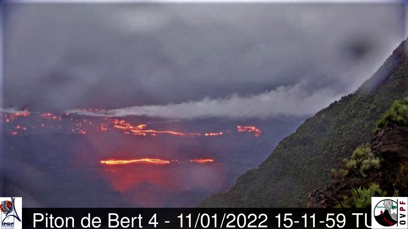
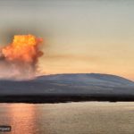
La Réunion Island , Piton de la Fournaise :
Press release of January 12, 2022, 9:00 a.m.
The eruption that began on December 22, 2021 at around 3:30 a.m. local time continues. Over the last 48 hours, the amplitude of the tremor has increased. Fluctuations in the amplitude of the tremor can still occur; they are linked in part to the level of the lava lake, which varies according to the mode of degassing, the erosion of the eruptive duct and the sporadic openings of the tunnels which allow the cone to emptying.

As in most of Reunion, bad weather conditions persist on the eruptive site. However, some observations could be made thanks to short clearings. These show that the lava projections at the level of the cone are still present and occasionally exceed the height of the cone. Regularly overflows of the lava lake are observed as well as numerous resurgences of lava flows at the roof of the lava tunnel downstream of the cone.

The images from the OVPF-IPGP-IRT webcam located at Piton de Bert show that the new flow arm put in place over the past 48 hours, and which runs along the southern rampart, is still active.
The front of this flow progresses only very slowly given the relatively low slopes in the area.
Over the last 24 hours:
– Four volcano-tectonic earthquakes, of low magnitude (<0.5), were recorded under the summit.
– The surface deformations still show a deflation at the level of the summit zone, linked to the emptying of the magma reservoir located under the summit (at about 2-2.5 km deep) feeding the eruptive site.
– Due to the very bad weather conditions on the volcano, no lava flow could be estimated by satellite method with the HOTVOLC platform (OPGC – Clermont Auvergne University).
Alert level: Alert 2-1 (eruption in the Enclos )
Source et photos : OVPF
Read the article : https://www.ipgp.fr/sites/default/files/ovpf_20220112_09h00_communique_eruption.pdf
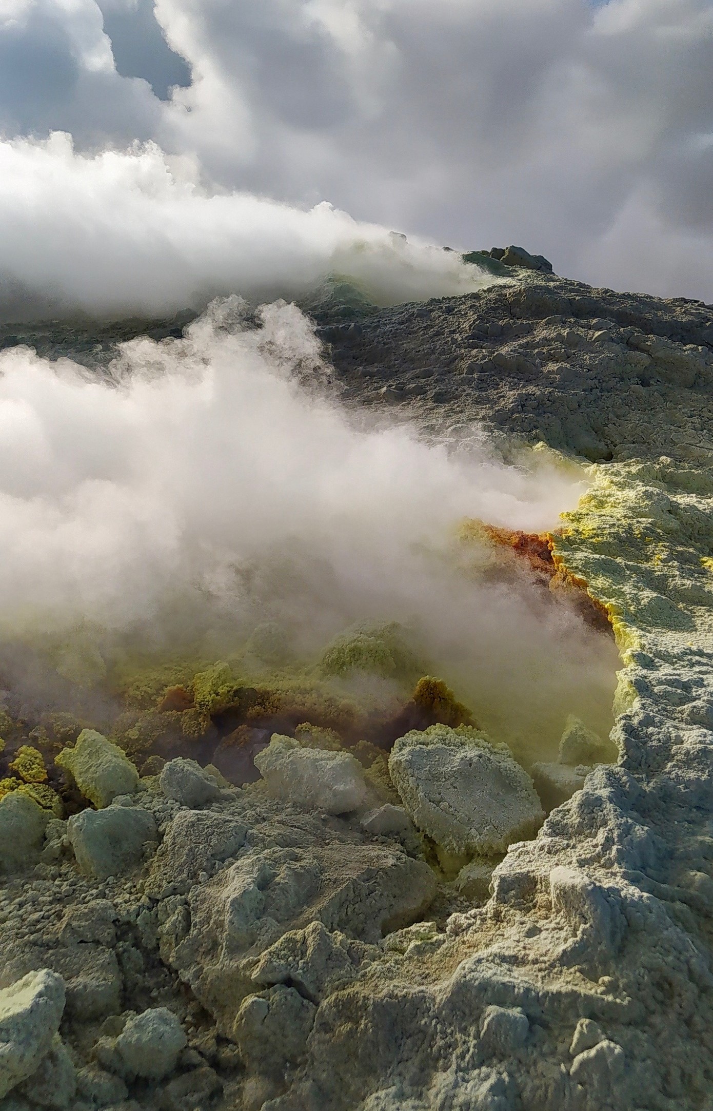
Italy , Vulcano :
WEEKLY NEWSLETTER, from January 03, 2022 to January 09, 2022 (issue date January 11, 2022)
SUMMARY OF THE STATE OF THE ACTIVITY
In the light of the surveillance data, it is highlighted:
1) Temperature of the fumaroles of the crater: The temperature values are stable both on the edge of the crater and on the internal face.
2) CO2 flux in the crater area: no updated data.
3) SO2 flux in the crater area: SO2 flux at a high level
4) Geochemistry of fumarolic gases: no update available
5) CO2 flux at the base of the La Fossa cone and in the area of Vulcano Porto: The soil CO2 flux values measured at the base of the cone showed a slight increase, reaching medium-high values.
6) Geochemistry of thermal aquifers: The physico-chemical parameters of the Sicilia and Bambara Camping sites are stable.
7) Local seismicity: Very low values in the frequency of occurrence of events of lower frequency (VLP).
8) Regional seismicity: No earthquake with Ml> = 1.0 was located in the area of the island of Vulcano.
9) Deformations – GNSS: The GNSS network does not show any variations during the period under review.
10) Deformations – inclinometry: The inclinometric network does not show significant variations during the examination week.
11) Other observations: Gravimetry: The continuous gravity stations did not record any significant variations during the period considered.
GB-RAR: The results of the GB-RAR monitoring for the period from December 14, 2021 to January 10, 2022, show a general stability of the area, with deformations along the LOS of less than 1 mm.
Mobile GNSS: Mobile GNSS stations show no significant change.
SO2 FLOW INTO THE CRATER ZONE
The average daily values recorded during the last week are in line with the values for the previous period. In the period following the increase recorded since September and which had peaked at the beginning of November, the average daily stabilization value of the flow of SO2 decreased to a high level (~ 120 t / d).
CO2 FLOWS AT THE BASE OF THE CONE DE LA FOSSA AND IN THE VULCANO PORTO AREA
Soil CO2 fluxes (acquired automatically by the VULCANOGAS network), in the last days of the observation period, showed a moderate upward trend in all sites. In the sites of Camping Sicilia and Rimessa, the current values remain high, although lower than those reached at the peak of the current crisis, while in the sites of Palizzi (P4max) and Faraglione, on the other hand, the flows have almost reached the maximum values of the last 12 months.

LOCAL SEISMICITY
During the week under consideration, the rate of occurrence of micro shakes with a spectral peak greater than 1 Hz did not show any significant changes compared to the previous week. With regard to lower frequency events (VLP; spectral peak less than 1 Hz), the decay phase is confirmed, observed from the last decade of December 2021, characterized by a very low rate of occurrence.
Source and graphic : INGV.
Photo : G. De Astis (INGV-Rome1)
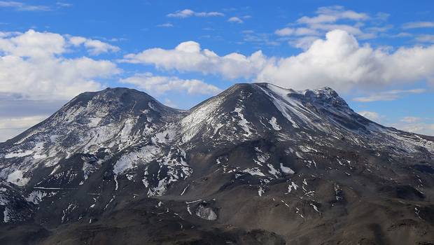
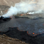
Chile , Nevados de Chillan :
Seismicity parameters associated with fracturing processes of rigid materials (type VT) recorded a decrease in the number of events and their associated energy, while events associated with fluid dynamics (type LP and VLP) also recorded a slight decrease in the number of events and energy levels compared to the previous period. There was a slight increase in the number of tremor pulse events (TR type) with a slight decrease in the associated energy levels. Explosive-type (EX-type) events showed a slight increase in quantity and decrease in associated energy levels for the period.
The highest energy VT-type event, with a local magnitude (ML) of 1.7, was located 6.5 km east (E) of the active crater and at a depth of 3 km.
From the analysis of the images provided by the surveillance cameras belonging to OVDAS as well as the satellite images, it was observed that the stop in the advance of the lava flows « L7 » and « L8 » is maintained. On the other hand, there was a contribution of new material in the zone of the active crater but without this generating a clear morphology on the surface due to the intermittence of the contribution or its low intensity.
The explosive activity, during the period evaluated, was generally characterized by a low content of pyroclasts and a dominance of water vapor. However, significant events were recorded on December 24 and 25, with a maximum column height of 1860 m above the emission point and a high pyroclast content.
There was a decrease in the frequency of nocturnal glow episodes, characterized by low-level, low-distribution events, with the exception of the occasional pulses that occurred on December 25.
According to data obtained by the network of GNSS stations installed on the volcano, the transition from a deflationary phase to an inflationary phase is observed, with stations recording an upward trend with rates of 0.5 cm / month, while that inclinometric stations showed variations in direction, these being more evident in stations near the active crater.
Twelve (12) thermal alerts were recorded in the area with a maximum value of 32 MW on December 21, a value considered moderate for this volcano. Radiance anomalies were also detected on December 16, 19, 21, 24, 26, 29 and 31 from Sentinel 2-L2A image analysis.
The DOAS gas measuring equipment recorded a maximum sulfur dioxide (SO2) emission value of 451 t / d for December 19 and 31, while the recorded average emission was 196 t / d. Proof that a decrease in gas emissions continues compared to the previous period, probably linked to a partial obstruction of the emission ducts.
Source : SEGEMAR.
Photo : 24 Horas
Italy / Sicily , Etna :
WEEKLY NEWSLETTER, from January 03, 2022 to January 09, 2022 (issue date January 11, 2022)
SUMMARY OF THE STATE OF THE ACTIVITY.
In the light of the surveillance data, it is highlighted:
1) VOLCANOLOGICAL OBSERVATIONS: Degassing activity at variable rate of all the summit craters. Sporadic and weak emissions of very dilute ash from the crater of Bocca Nuova.
2) SEISMOLOGY: Moderate increase in the rate of earthquakes, low energy releases; average amplitude of low-level tremors
3) INFRASOUND: moderate increase in infrasound activity.
4) SOIL DEFORMATION: During the last week, the soil deformation monitoring networks have not recorded any significant changes.
5) GEOCHEMISTRY: SO2 flux at a medium-low level
CO2 flows on the ground recorded by the Etnagas network at average levels.
Partial pressure of dissolved CO2 at values consistent with the seasonal trend.
There is no update on the isotopic ratio of helium in peripheral manifestations (latest data from 16.12.2021 on medium-high levels).
There are no updates for the C / S report.
6) SATELLITE OBSERVATIONS: The thermal activity in the summit area observed by satellite was low.
VOLCANOLOGICAL OBSERVATIONS
During the week under review, the monitoring of the volcanic activity of Mount Etna was carried out through the analysis of images from the INVV surveillance camera network of the Mount Etna Observatory ( INGV-OE) and through remote observations by INGV staff. At the beginning of the week, observations were often made difficult by adverse weather conditions. The period was characterized by variable degassing activity of all summit craters, with sustained degassing activity at Bocca Nuova Crater and a few high-temperature points at Southeast Crater.
Source : INGV
Photo : Gio Giusa.
New Zealand , Ruapehu :
VOLCANIC ALERT BULLETIN, Wed Jan 12 2022 2:30 PM;
Volcanic Alert Level remains at 1
Aviation Colour Code remains at Green
A recent cluster of earthquakes has occurred beneath Ruapehu’s summit. All monitoring data at Ruapehu indicates that volcanic unrest remains at minor levels. The Volcanic Alert Level at Mt Ruapehu stays at Level 1.

Earthquakes regularly occur in the Tongariro National Park, and towards the southern portion around Ruapehu, we often record them near Waiouru and National Park Village. There are two broad styles of earthquakes at volcanoes: volcanic earthquakes (which includes tremor) that are directly related to the movement of fluids (magma and/or the hydrothermal system), and tectonic earthquakes which result from rocks fracturing (movement on small faults).
From 30 December 2021, we have recorded a sequence of tectonic earthquakes located beneath Ruapehu’s summit area. So far, there have been at least 30 distinct earthquakes in this sequence. When compared to historical records, the number of earthquakes with epicentres closely confined to the summit area, is unusual. While these earthquake clusters are uncommon, none of our monitoring data suggests that the volcano is exhibiting increased levels of activity.

There has been no observable response from other continuous monitoring data such as Crater Lake (Te Wai ā-moe) temperature, lake level, or volcanic tremor. Therefore, our current assessment is that a relatively deep stress release has occurred below the volcano, but this has not affected the volcano’s hydrothermal system.
Our team will be conducting a scheduled gas flight and will sample Ruapehu’s Crater Lake (Te Wai ā-moe) in the coming days, weather permitting.
The Volcanic Alert Level stays at Level 1 which reflects the current level of volcanic unrest. The Volcanic Alert Level should not be used to forecast future activity.
The Aviation Colour Code remains at colour Green.
Mt Ruapehu is an active volcano and has the potential to erupt with little or no warning when in a state of volcanic unrest.
Source : Geonet / Geoff Kilgour Duty Volcanologue
Photo : Bradd Scott / GNSS


No comment yet, add your voice below!