
November 24 , 2021.
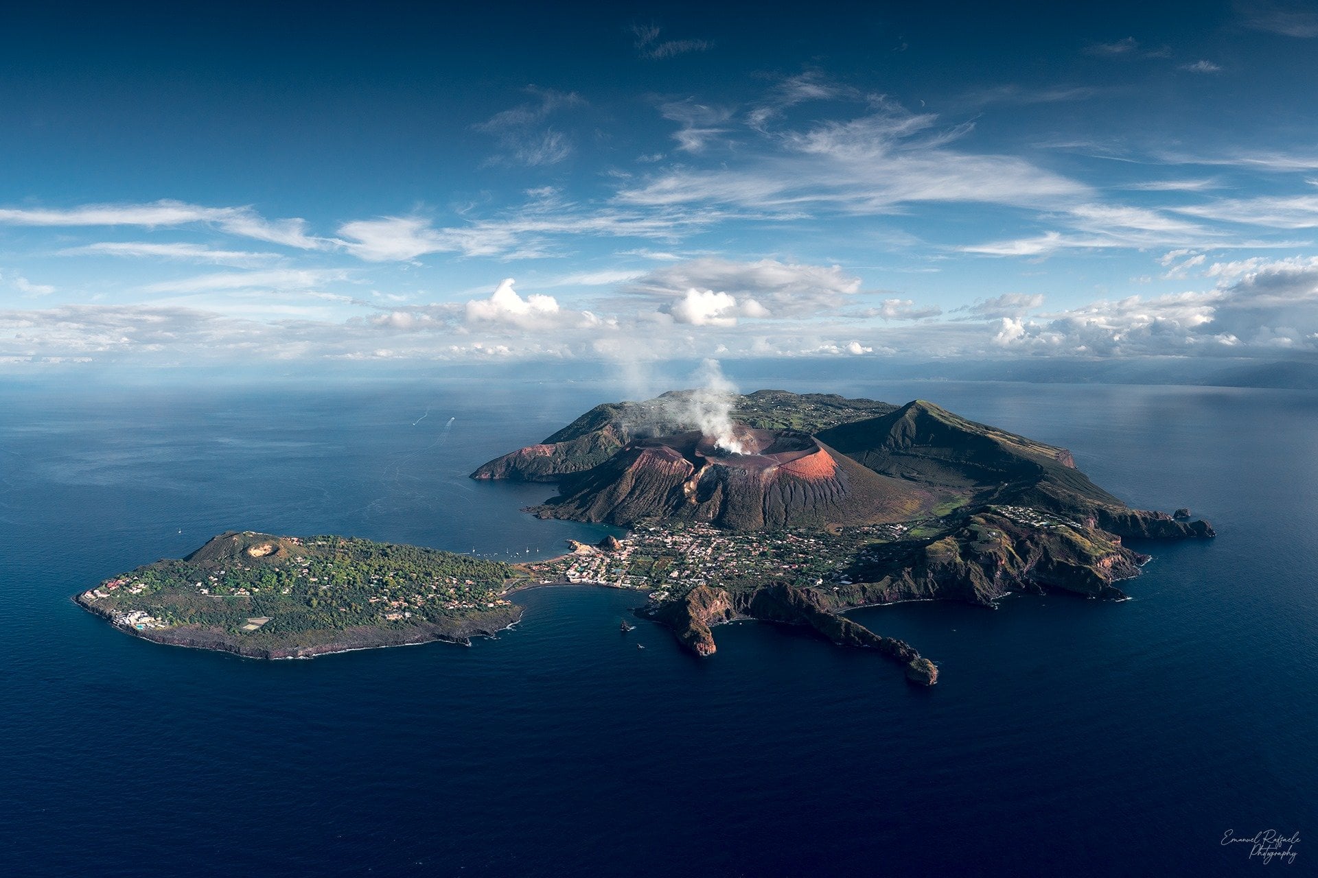
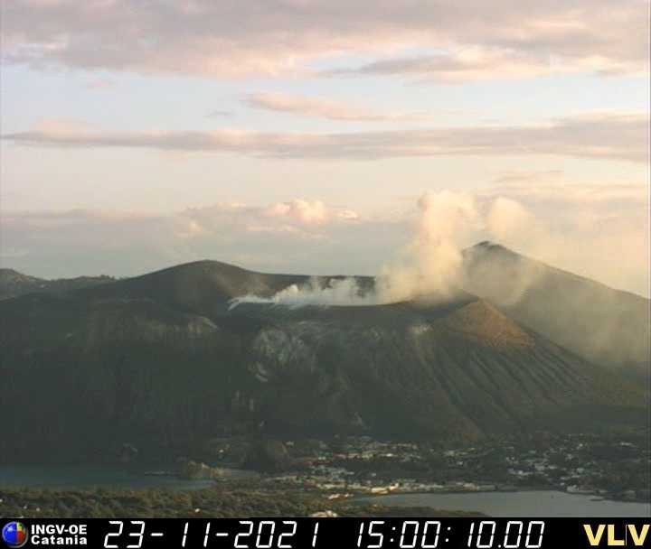
Italy , Vulcano :
Weekly bulletin from November 15, 2021 to November 21, 2021 (issue date November 23, 2021)
SUMMARY OF THE STATUS OF THE ACTIVITY.
In view of the monitoring data, it is highlighted:
1) Temperature of the fumaroles of the crater: Stable temperature values both on the edge and on the internal face, in line with those of the previous week
2) CO2 flux in the crater area: Values increasing on very high and abnormal levels (13743 g / m2 / day)
3) SO2 flux in the crater area: SO2 flux appears at a high level
4) Geochemistry of fumarolic gases: No update is available.
5) CO2 flow at the base of the La Fossa cone and in the Vulcano Porto area: The flow measurements at the base of the cone acquired automatically by the VULCANOGAS network continue to show high and growing values from the Camping Sicilia site.
6) Geochemistry of thermal aquifers: temperature and conductivity values slightly increasing in the C. Sicilia well; the temperatures recorded are at very high values while the conductivity at very low values. Decrease in the level and values of conductivity in the Bambara well.
7) Local seismicity: The phase of local seismicity reduction continues, with particular reference to low frequency events (VLP).
8) Regional seismicity: low-level fracturing seismicity: 1 single earthquake with Ml = 1.3
9) Deformations – GNSS: Data from GNSS networks show, last week, a tendency to increase the expansion of the area.
10) Deformations – Inclinometry: Slight variation of the uptrend from November 20
11) Other observations: Gravimetry: Only very localized and rapid gravimetric variations with a limited amplitude are recorded. There is no indication of significant deep mass redistributions.
Geochemistry of the Vulcano wells (Campaign of November 16, 2021): In the water of the C. Sicily, Muscarà and Bambara wells, a significant increase in dissolved carbonate species is observed. A considerable increase in temperature, decrease in pH and salinity are also observed in the C. Sicilia well only.
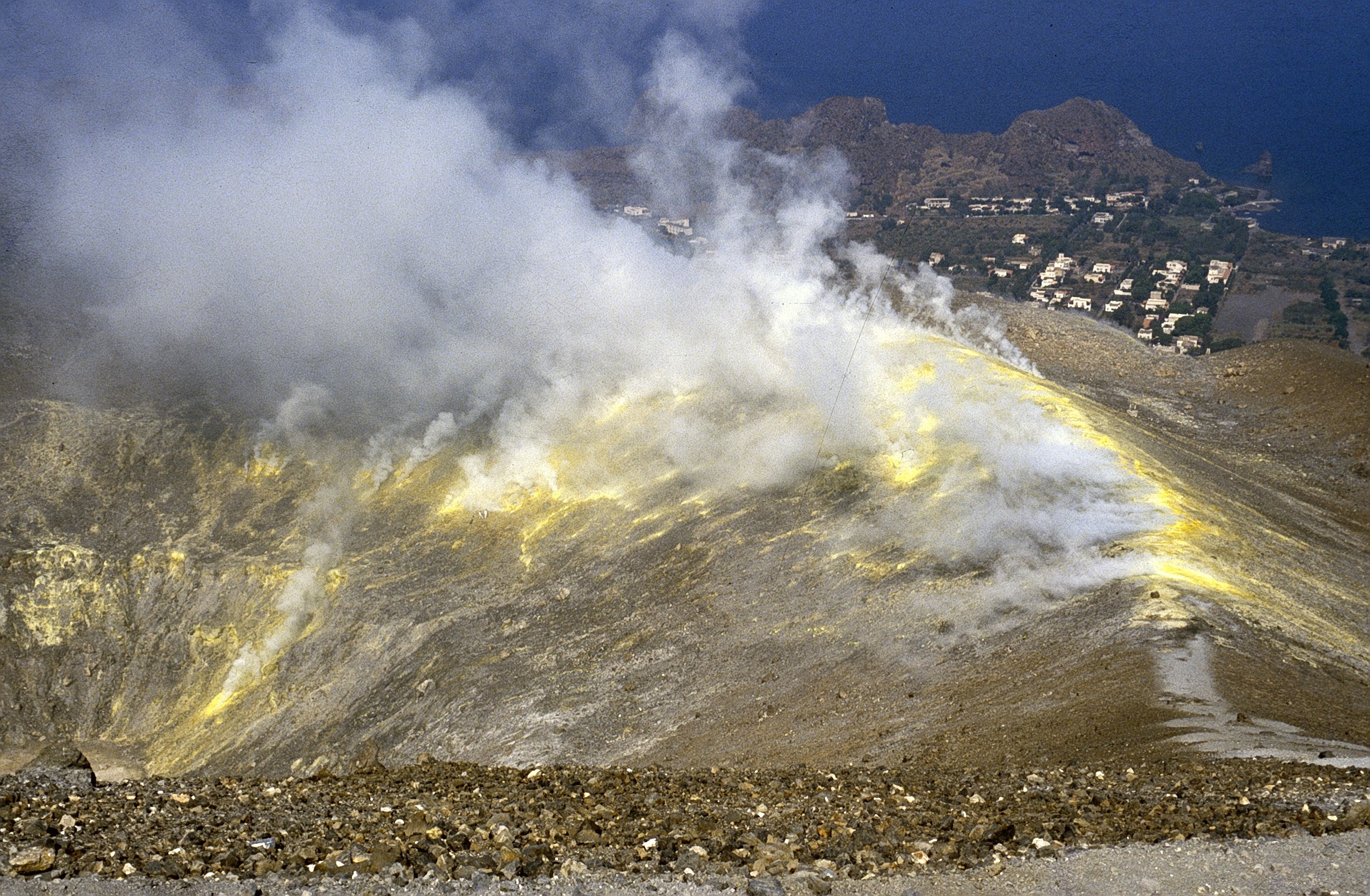
TEMPERATURE OF CRATERIC FUMAROLES
For the current week (November 16-23), the maximum temperature emission showed the average value of 319 ° C (fumarole F5, measurements in the range 282-352 ° C). The percentage of validated data is 100% for all sensors. The F5AT fumarole has a range of values between 291 and 330 ° C.
The continuously monitored temperatures on the inside show a range of values between 98 and 110 ° C. This fumarole resumed its positive trend, not very pronounced, after a period of interruption (between 14 and 18 November).
PORTO VULCANO
CO2 fluxes remain at high levels with little variation compared to last week. There is a clear upward trend at Camping Sicilia Rimessa and Faraglione resorts. Soil CO2 flux values at the P4max station remain at high values but with a slight drop last week
Source : INGV.
Photos : Emanuel Raffaele Photography, Boris Behncke , INGV.
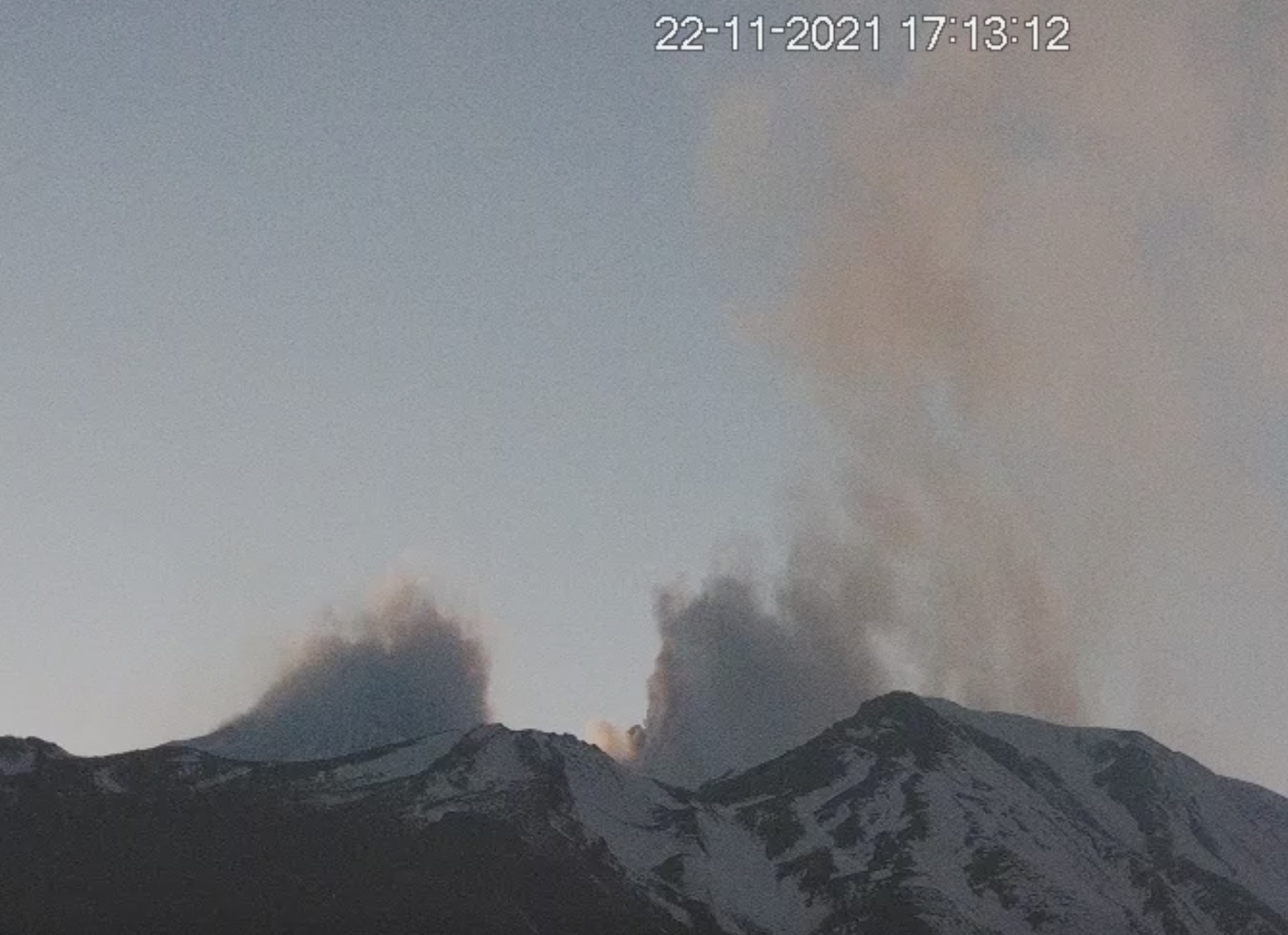
Italy / Sicily , Etna :
Weekly bulletin from November 15, 2021 to November 21, 2021 (issue date November 23, 2021)
SUMMARY OF ACTIVITY STATUS
In view of the monitoring data, it is highlighted:
1) VOLCANOLOGICAL OBSERVATIONS: Mainly degassing activities at summit craters. Explosive activity at the Northeast Crater with diluted ash emissions.
2) SEISMOLOGY: Seismic activity of weak fracturing. Amplitude of the volcanic tremor on the medium-low level.
3) INFRASON: moderate infrasound activity
4) DEFORMATIONS: The deformations of the ground measured by the GNSS and inclinometric networks did not show any significant changes during the last week.
5) GEOCHEMISTRY: The flow of SO2 is placed at an average level.
The flow of CO2 emitted by soils recorded by the Etna GAS network last week was at medium-high values.
The partial pressure of dissolved CO2 in water shows a slight increase even though it is at average levels.
There is no update for the helium isotope ratio, the latest data from 10/20/2021 is set to medium to high values.
There are no updates for the C / S report.
6) SATELLITE OBSERVATIONS: The thermal activity in the summit area was at a low level.

VOLCANOLOGICAL OBSERVATIONS
The monitoring of the volcanic activity of Etna, during the week in question, was carried out by analyzing the images of the network of surveillance cameras INGV, Osservatorio Etneo (INGV-OE). The bad weather conditions made the observation of the volcanic activity discontinuous through the network of cameras.
The activity at the summit craters did not show any changes compared to what had been observed the previous week, continuing with an intense degassing activity mainly carried out by the Bocca Nuova. On the 20th, starting at 10:16 UTC at the Northeast Crater, explosive activity was observed with emissions of diluted ash which rapidly dispersed in the summit area.
Volcanic tremor:
The mean amplitude of the volcanic tremor remained at medium-low values throughout the week and the source centroids were mainly located in the area of the Bocca Nuova and Voragine craters at altitudes between 2700 and 2900 m altitude.
November 23, 2021, 3:30 p.m. (2:30 p.m. UTC). COMMUNICATION ON THE ACTIVITY OF ETNA.
The National Institute of Geophysics and Volcanology, Osservatorio Etneo announces that in the last 48 hours the explosive activity at the level of the North-East crater reported in the press release of 11/20/2021 n ° 517 has not been observed by the surveillance cameras. modest energy activity generated slight ash emissions which scattered near the summit area. During the last 48 hours, the amplitude of the volcanic tremor did not show significant changes, remaining at medium-low values. The number of infrasound events is on average values and they are located in correspondence with the crater of Bocca Nuova.
GNSS and inclinometric monitoring networks for soil deformation do not show significant variations.
Further updates will be communicated shortly.
Source : INGV.
Photos : Gio giusa , Webcam.
Spain / La Palma , Cumbre Vieja :
November 23, 2021, 09:00 UTC. Eruptive activity continues on La Palma.
Since the last declaration, a total of 98 earthquakes have been located following the volcanic reactivation of the Cumbre Vieja region, six of which were felt by the population. The maximum recorded magnitude is 4.8 (mbLg) corresponding to the earthquake felt with maximum intensity IV in the epicentral zone at 01:03 UTC today.
In the period considered, 84 earthquakes were located at a depth of about 30 km, the rest of the hypocenters of the period are located at a shallower depth, about 12 km.
The amplitude of the volcanic tremor signal continues at medium low levels with intensifying pulses.
The island’s network of permanent GNSS stations shows an elevation reversal recorded between November 17 and 19 and a slight deformation to the southwest at station LP03, which is closest to the eruptive centers.
In the rest of the stations, the slight deflation perhaps linked to the deep seismicity stabilized, except in LP01 which recorded it again.
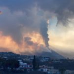
In view of the image calibrated at 08:45 UTC, a column height of 3,700 m is estimated, and a cloud is diffusing in the easterly direction.
La Palma Airport is still closed.
Aena reported on Tuesday that La Palma airport continues to be closed after four days of shutdown due to ash buildup from the volcano. Binter airline assures that at least until 1:00 p.m. today, operations with La Palma will continue to be paralyzed.
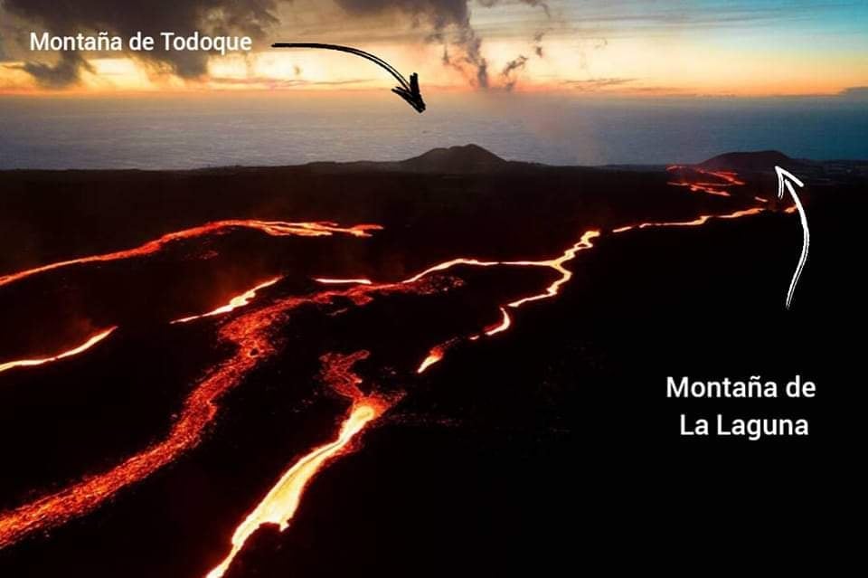
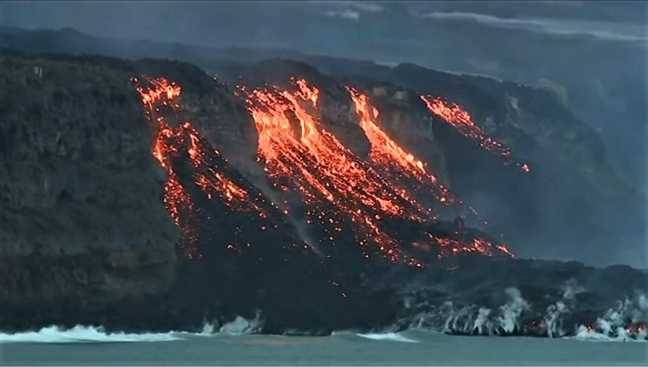
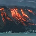
This Monday at 12:03 a new flow arrived at the sea (in zone 7) on the beach of La Viña. The flow of zones 4 and 7 is still active, occupying an additional nine hectares yesterday morning.
The cloud of ash and sulfur dioxide is expected to remain oriented east-northeast from the eruptive focus, possibly an unfavorable scenario for aeronautical operability, mainly for the airport of La Palma, if the effusive activity of the volcano continues in the same way.
The level of seismicity increased at depths greater than 20 km. The maximum magnitude was 4.8 mbLg from an event today at 1:03 am at a depth of 39 km, felt with intensity IV (on the EMS intensity scale).
The number of people staying in hotels stands at 505, two more than yesterday, including 72 in Los Llanos de Aridane and 433 in Fuencaliente. The number of dependents accommodated in social health centers on the island remains at 43.
The area affected by the lava is already 1,073.21 hectares, nearly 13 more than Monday. The southernmost delta reaches 43.46 hectares.
Source : IGN es , El Pais.
Photos : RTVE Noticias . Volcanes y Ciencia Hoy .
Colombia , Nevado del Ruiz :
Bulletin of the activity level of the Nevado del Ruiz volcano.
The activity level continues at: Yellow activity level or (III): Changes in the behavior of volcanic activity.
Regarding the monitoring of the activity of the Nevado del Ruiz volcano, the COLOMBIAN GEOLOGICAL SERVICE reports that:
Seismicity related to fluid dynamics inside volcanic conduits decreased in number of earthquakes recorded and increased in seismic energy released compared to the previous week. This seismic activity was characterized by the appearance of continuous volcanic tremor, tremor pulses, earthquakes of long and very long period types, which presented moderate energy levels and variable spectral content. These earthquakes were located mainly in the Arenas crater. Some of these signals were associated with ash emissions, confirmed by cameras installed in the volcano area and by the report of Los Nevados National Natural Park officials and Colombian Geological Service staff in the field.
The seismicity generated by rock fracturing has decreased in number of earthquakes and in seismic energy released compared to the previous week. This seismic activity was located mainly in the South-South-West, South-East and North-North-West sectors of the volcano and in the Arenas crater. The depths of the earthquakes ranged from 0.5 to 8.1 km. The maximum magnitude recorded during the week was 1.1 ML (Local Magnitude) corresponding to the earthquake recorded on November 19 at 03:21 (local time), located 3.2 km southeast of the Arenas crater, at 2, 7 km deep.
Source et photo : SGC.
Costa Rica , Turrialba :
Activity report of the Turrialba volcano 23 November 2021.
On 23 November 21 at 6:24 a.m. local time, an eruption was recorded on the Turrialba volcano, with a column that rose to 500 meters above the height of the crater and to 3840 m (meters above the level of sea, 12,595.2 feet).
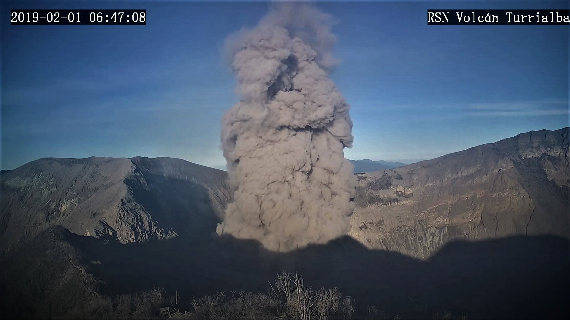
Duration of activity: 1 minute.
The winds are blowing in the southwest.
Ash falls reported: No ash falls are reported
Sulfur odor reported: No sulfur odor reported.
At the time of this report, the winds are blowing from the west.
There is no volcanic tremor. Degassing is observed in the crater. Gas ratios remain stable. The deformation of the volcanic building remains stable with slight deflation.
Source : Ovsicori
Photo : Archive RSN
Chile , Nevados de Chillan :
Special Report on Volcanic Activity (REAV), Ñuble region, Nevados de Chillán volcanic complex, November 23, 2021, 11:11 a.m. local time (Continental Chile).
The National Service of Geology and Mines of Chile (Sernageomin) publishes the following PRELIMINARY information, obtained thanks to the monitoring equipment of the National Volcanic Monitoring Network (RNVV), processed and analyzed at the Volcanological Observatory of the Southern Andes ( Ovdas):
On Tuesday 23 November 2021, at 10:28 am local time (13:28 UTC), the monitoring stations installed near the volcanic complex of Nevados de Chillán recorded an earthquake associated with the fracturing of rocks (volcano-tectonic type VT) in the volcanic system .
The characteristics of earthquakes after their analysis are as follows:
ORIGINAL TIME: 10:28 am local time (13:28 UTC)
LATITUDE: 36.846 ° S
LONGITUDE: 71.377 ° W
DEPTH: 3.0 km
LOCAL MAGNITUDE: 3.1 (Ml)
OBSERVATIONS:
16 other lower magnitude VT-type events were observed.
The volcanic technical alert remains at the Yellow level.
Source : Sernageomin.
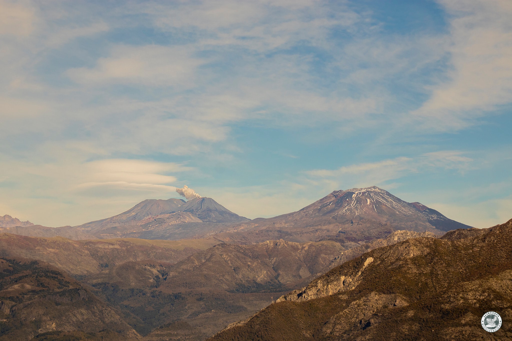
Photo : Josefauna.


No comment yet, add your voice below!