September 12 , 2021.
Italy , Stromboli :
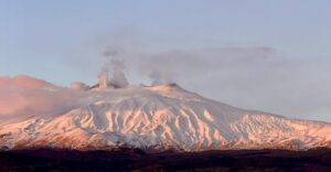
PRESS RELEASE ON THE ACTIVITY OF STROMBOLI, September 11, 2021, 21:17 (19:17 UTC).
The National Institute of Geophysics and Volcanology, Osservatorio Etneo announces that the monitoring networks recorded a variation of the monitored parameters at 21:16 (19:16 UTC).
In particular, a thermal anomaly is observed from the surveillance cameras.
PRESS RELEASE ON THE ACTIVITY OF STROMBOLI, September 11, 2021, 21:51 (19:51 UTC).
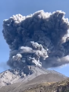
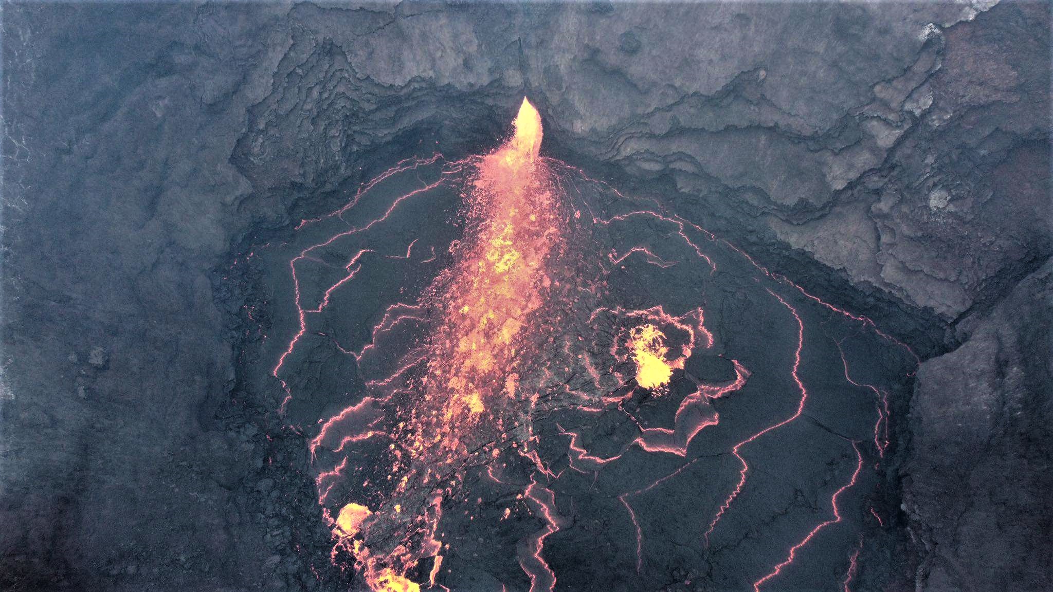
The National Institute of Geophysics and Volcanology, Osservatorio Etneo, announces that from 19:09 UTC, the surveillance networks recorded an explosive event of greater intensity than usual. The event produced a significant emission of matter which passed through the crater terrace as it rolled along the Sciara del Fuoco. Due to the cloud cover, observations are very limited.
At 19:09 (UTC) the seismic network of the island of Stromboli recorded a seismic event, linked to an explosion, with an amplitude well above the average of the amplitudes of the events recorded recently. This seismic event was followed after about 1 minute by another event of high amplitude and others of lesser amplitude.
After the first event, the seismic signal remained at high levels for about 3.5 minutes due to the rolling phenomena of the products emitted.
At 19:13 (UTC), the average amplitude of the seismic signal returned to the medium-low levels that preceded the event. There are no significant changes in the number and magnitude of VLP events.
Signals from soil deformation monitoring networks, GNSS and inclinometry, do not show significant variations
The monitoring networks recorded the return of the parameters to normal activity at 23:02 (21:02 UTC).
Further updates will be communicated shortly
Source : INGV.
Photo : Webcam.
Iceland , Geldingadalur / Fagradalsfjall :
Update on the Fagradalsfjall mountain eruption on 12-September-2021
This is a late and short update on the eruption in Fagradalsfjall mountain on 12-September-2021. Fagradalsfjall mountain is part of Krýsuvík-Trölladyngja volcano system.
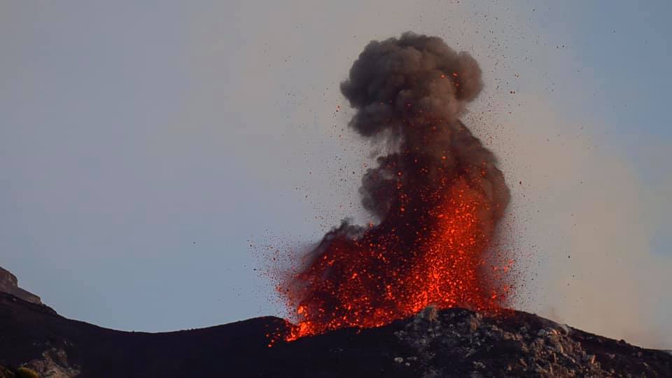
Yesterday (11-September-2021) at around 05:00 the harmonic tremor on SIL stations around Fagradalsfjall mountain started to show an increase in harmonic tremor after a break of 8 days. It took few hours for the magma to reach the crater and lava was visible in the crater around 12:00 UTC.

Increasing harmonic tremor at 00:38 UTC on Fagradalsfjall mountain SIL station. Copyright of this image belongs to Icelandic Met Office.
There have been possible new vents been opening up yesterday and today in the lava field. Icelandic Met Office says that this is a lava flow under the old colder lava and is now breaking up and looking like new vents. I don’t know yet if this is accurate, but it is my early assessment that this are new vents and are going to build new crater, at least there is a possibly of crater building if the new vents stay active long enough.
Geldingadalur wakes up again
Lava was observed in Geldingadalur volcano this morning, there had been no activity for nine days. Here you can see the photos that Donatas Arlauskas took today.
“There was unrest in Geldingadalur again early this morning, probably around five o’clock or something like that and it continues to increase. We haven’t seen any lava emerge from the crater yet, but it may take a while. time from when the turbulence starts to increase until we start to see something, « says Böðvar Sveinsson, nature conservation specialist at the Icelandic Meteorological Bureau. Although the volcano has been calm for some time , until this morning, Böðvar said that experts had not started to consider declaring the end of the eruption.
Seismicity continues over Askja and there were seven minor earthquakes in the area this morning, but Böðvar says this is not unusual in this area.
Source : icelandgeology.net , RUV.
Photos : Icelandic Met Office , Donatas Arlauskas / RUV.
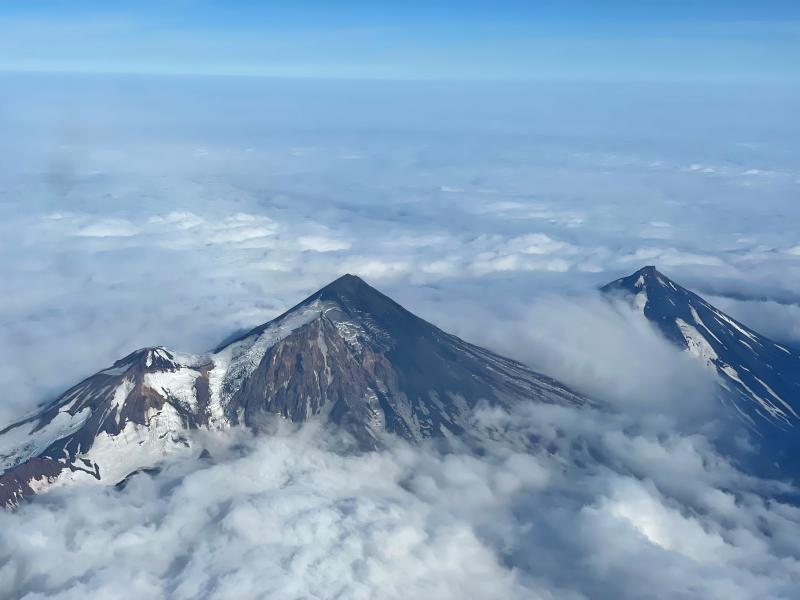
Alaska , Pavlof :
55°25’2″ N 161°53’37 » W,
Summit Elevation 8261 ft (2518 m)
Current Volcano Alert Level: WATCH
Current Aviation Color Code: ORANGE
Unrest continues at Pavlof Volcano, with 4 very minor ash emissions observed in web camera images during a 5-hour period of clear weather yesterday afternoon. These emissions from a vent on the east flank were so weak that they didn’t rise to the elevation of the summit. They dissipated within minutes and didn’t travel very far from the vent. Seismicity continues but at low levels. Additional small explosions accompanied by low-level ash emissions could happen at any time.
The level of unrest at Pavlof can change quickly and the progression to more significant eruptive activity can occur with little or no warning. Pavlof Volcano is monitored by local seismic and infrasound sensors, satellite data, web cameras, and remote infrasound and lightning networks.
Source : AVO.
Photo : Ben David Jacob. 20 Aout 2021 .
Costa Rica , Rincon de la Vieja / Turrialba / Poas :
Volcanic Watch Program Weekly Bulletin, September 6, 2021.
Rincón de la Vieja volcano
Lat: 10.83 ° N; Long: 85.324 ° W;
Altitude: 1895 m.s.n.m.
Current activity level: 3 (erupting volcano)
Potentially associated hazards: lahars, gas, phreatic eruptions, proximal ballistic projections, ash falls, acid rain.

A small phreatic eruption was recorded on September 1. There was no visual observation. The number of « Tornillos » type events is decreasing and the number of LP type events is stable. RSAM decreased significantly after the last eruption and few VT-type events were recorded. Geodetic GPS monitoring shows localized narrowing at the top.
Turrialba volcano
Lat: 10.025 ° N; Long: 83.767 ° W;
Altitude: 3340 m.s.n.m.
Current activity level: 2 (active volcano)
Potentially associated hazards: gas, ash emission, proximal ballistic projections, acid rain.
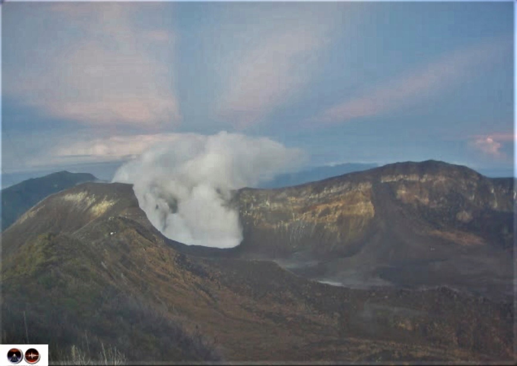
The last confirmed eruption took place on July 26. The number of low frequency LP type events decreases, the number of high frequency LP type events and short tremors increases. RSAM remains relatively low. Geodetic tracking with GPS shows a contraction on the Irazú-Turrialba massif during the last 3 months. The CO2 / SO2 and H2S / SO2 ratios of the gases do not show significant changes. The SO2 flow has a weekly average of 141 +/- 130 t / d.
Poas volcano
Lat: 10.2 ° N; Long: 84.233 ° W;
Height: 2780 m.s.n.m.
Current activity level: 2 (active volcano)
Potentially associated hazards: gas, phreatic eruptions, proximal ballistic projections, lahars, acid rain.
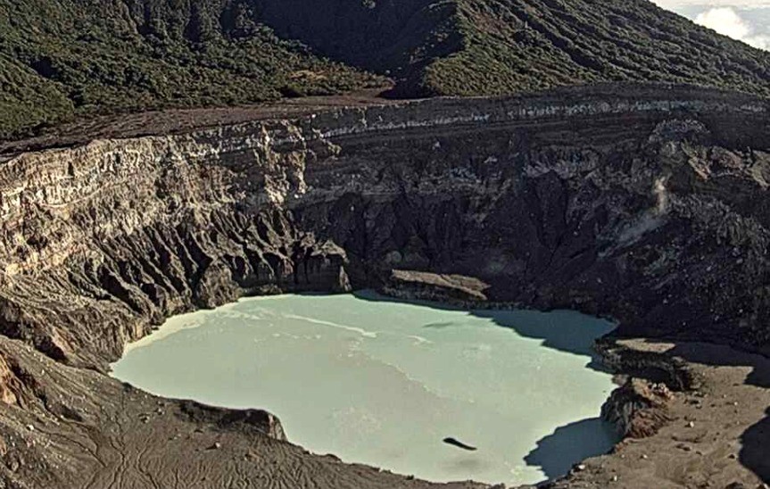
No eruption was observed. The number of daily LP type events remains high. Short tremors continue to be recorded every 10 to 60 minutes, with a low amplitude. RSAM remains relatively low. GPS geodetic monitoring shows long term expansion and inflation, small short term expansion. The SO2 / CO2 and H2S / SO2 gas ratios remain stable. The maximum SO2 concentration detected at the lookout was 1.8 ppm last week. The SO2 flow shows a weekly average of 70 +/- 77 t / d, very similar to that of the previous weeks. The level of the hyper-acidic lake showed a slight increase of 10 cm.
Source : Ovsicori
Photos : , Federico Chavarría-Kopper / Ovsicori , Ovsicori .
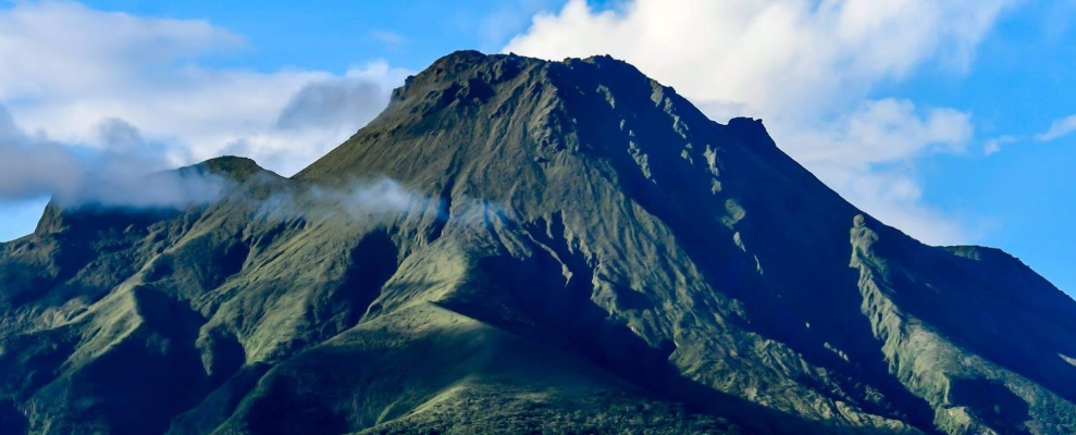
La Martinique , Mount Pelée :
Weekly report on the activity of Mount Pelée for the period from September 03 to September 10, 2021.
Between September 3, 2021 at 4 p.m. (UTC) and September 10, 2021 at 4 p.m. (UTC), OVSM recorded at least 73 volcano-tectonic earthquakes of magnitude less than or equal to 1.0. These earthquakes were located inside the volcanic edifice between 2.5 km below sea level and the surface. None of these earthquakes were felt by the population. This volcano-tectonic-type superficial seismicity is associated with the formation of micro-fractures in the volcanic edifice.
A degassing zone at sea was detected at shallow depth (between St Pierre and le Prêcheur). The IGP is currently setting up experiments to map this gas emanation zone, carry out physicochemical measurements of the fluids and samples of these fluids in order to understand the origin of this degassing and to assess its possible relationship. with the hydrothermal system of Mount Pelée. This kind of manifestation is frequent on active or not active underwater volcanic sites. The analyzes underway by the OVSM-IPGP will make it possible to determine the possible relationship of this underwater degassing with the activity of Mount Pelée recorded by the OVSM since 2019.
A main area of heavily degraded vegetation is still observed on the southwest flank of Mount Pelée, between the upper Claire River and the Chaude River.
The alert level remains YELLOW: vigilance.
Source : Direction de l’OVSM IPGP.
Photo : ville-saintemarie