August 29 , 2023.
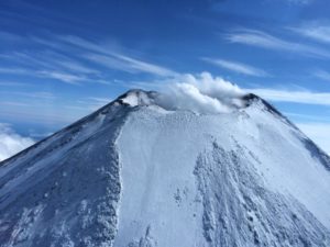
Alaska , Shishaldin :
54°45’19 » N 163°58’16 » W,
Summit Elevation 9373 ft (2857 m)
Current Volcano Alert Level: WATCH
Current Aviation Color Code: ORANGE
Low-level explosive activity is probably occurring within the summit crater of Shishaldin Volcano, based on seismic data and strongly elevated surface temperatures visible in satellite images over the past day. An AVO field crew working on Unimak Island observed a mass flow down the upper flanks of the volcano beginning around 0120 UTC (5:20 pm AKDT on 8/27/23). The flow produced a short-lived ash cloud that rose to about 15,000 ft (4.5 km) above sea level and quickly dissipated. These mass flows are likely caused by the collapse of lava spatter that is accumulating on the summit crater rim. The deposits collapse occasionally without warning and generate hot flows on the upper flanks and small clouds of volcanic ash.

Shishaldin has now had eight periods of elevated eruptive activity resulting in significant ash emissions and mass flows of volcanic debris on the volcano’s flanks. The ongoing eruptive period started on July 12, and it is unknown how long this eruptive episode will last. However, previous eruptions of Shishaldin Volcano have lasted weeks to months with repeated cycles of activity like those seen over the last month.
Local seismic and infrasound sensors, web cameras, and a geodetic network monitor Shishaldin Volcano. In addition to the local monitoring network, AVO uses nearby geophysical networks, regional infrasound and lighting data, and satellite images to detect eruptions.
Source : AVO.
Photo : Nick Enloe
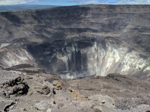
Hawaii , Kilauea :
Monday, August 28, 2023, 8:48 AM HST (Monday, August 28, 2023, 18:48 UTC)
19°25’16 » N 155°17’13 » W,
Summit Elevation 4091 ft (1247 m)
Current Volcano Alert Level: ADVISORY
Current Aviation Color Code: YELLOW
Activity Summary:
Kīlauea volcano is not erupting. Kīlauea summit is currently exhibiting signs of elevated unrest. No unusual activity has been noted along Kilauea’s East Rift Zone or Southwest Rift zone.
Summit Observations:
Elevated seismic activity continues in an area south of Kīlauea’s summit caldera. Earthquakes occurred steadily through the day yesterday, without swarm activity. Most earthquakes have been at a depth of 1-2 miles (2-3 km) below the surface, with no upward migration. Summit tiltmeters showed inflationary tilt through most of yesterday, consistent with recent trends, but are showing some variability this morning. Sulfur dioxide (SO2) emissions from the summit remain low; the most recent SO2 emission rate, of approximately 75 tonnes per day, was measured on August 24.

The earthquake activity and tiltmeter data indicate that Kīlauea summit is becoming increasingly pressurized. Similar episodes of earthquake and ground deformation activity occurred in November 2020 and August 2021, prior to eruptions in December 2020 and September 2021. The activity is currently confined within Kīlauea’s summit region and if it continues, could escalate to an eruption in the coming days, weeks, or months. The activity could also decrease due to intrusion of magma underground or other changes, resulting in no eruption. Furthermore, levels of activity are expected to rise and fall during this period.
Halemaʻumaʻu crater Observations:
No active lava has been observed since June 19.
East Rift Zone Observations:
No unusual activity has been noted along the East Rift Zone or Southwest Rift Zone; steady rates of ground deformation and seismicity continue along both. Measurements from continuous gas monitoring stations downwind of Puʻuʻōʻō in the middle East Rift Zone remain below detection limits for SO2, indicating that SO2 emissions from Puʻuʻōʻō are negligible.
Source : HVO
Photo : USGS/ M. Zoeller.
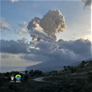
Peru , Ubinas :
Analysis period: August 22, 2023 – August 27, 2023. Arequipa, August 28, 2023.
Alert level: ORANGE
The Geophysical Institute of Peru (IGP) reports that the eruptive processes of the Ubinas volcano (Moquegua region) maintain moderate levels. During this period, 1 volcanic explosion as well as emissions of ballistic blocks, ash and gas which reached up to 4200 m above the summit of the volcano were recorded. For this, it is suggested to the authorities to maintain the volcanic alert level at the Orange level.
During the analysis period, the occurrence of 229 volcano-tectonic (VT) type earthquakes was detected, associated with rock rupture processes that occur inside the volcano. In addition, 54 long-period (LP) type seismic signals were recorded, associated with the movements of volcanic fluids (gas and magma), with a maximum energy of 2.1 Megajoules. Finally, it was identified a duration of 8 hours / day of seismic recordings in relation to ash emissions with a maximum of 17 hours, recorded on August 23. During this period, 1 volcanic explosion was recorded (August 25 at 5:57 p.m. local time). Finally, on August 23, 2023 at 1:30 p.m., the IGP recorded an earthquake of M3.3, located 1 km south of the town of Ubinas, 6 km deep.
Surveillance cameras identified volcanic explosions with emissions of ballistic blocks, columns of gas and ash that reached heights of 4200 m above the summit of the volcano, which were dispersed mainly to the northern sectors. , North-West, West, South-West, South-East, East and North-East of the Ubinas volcano with a radius of 25 km. On the other hand, the monitoring of the deformation of the volcanic structure, show variations of less than 7 mm of displacement (slight tendency to inflation). Satellite monitoring has not shown any thermal anomalies in the Ubinas crater.
RECOMMENDATIONS
• Maintain Volcanic Alert Level at ORANGE.
Source : Cenvul
Photo : Arusa
Costa Rica , Rincon de la Vieja / Poas / Turrialba / Irazu :
Weekly volcanic monitoring bulletin OVSICORI-UNA, August 25, 2023
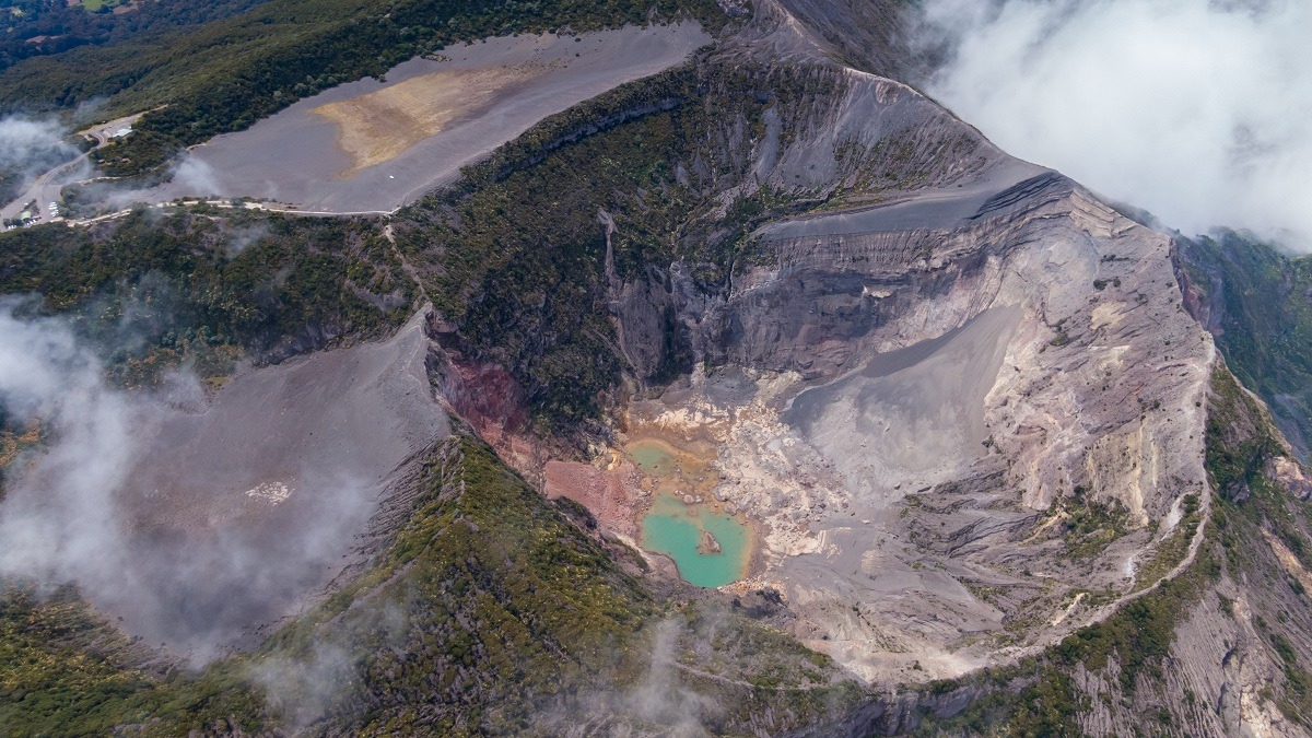
Rincon de la Vieja Volcano
Latitude: 10.83°N;
Longitude: 85.34°W;
Altitude: 1916 m above sea level.
Current activity level: Warning
Possible events:
Small eruptions, gush or geyser, large gas emission, temperature increase (incandescence), seismic swarms or volcanic tremor, slight inflation-expansion of the volcanic edifice, hot springs).
An increase in the number of hydrothermal eruptions is observed, mainly during the last two days. During this week, the tremor remained fairly stable and intensified, increasing signal amplitude and frequency content. Volcano-tectonic earthquakes are again recorded at the top of the volcano. Geodetic measurements detect a slight uplift in the northern region of the volcano with an extension of the base of the volcanic edifice, although the latter is reduced. The summit shows subsidence and a movement towards the South-West.
During the previous week, an average SO2 flux of 240 ± 130 t/d was recorded. Although this flow rate is higher than that of the previous week (152 ± 66 t/d), it does not represent a significant variation. The gas ratios measured in the plume remain within the typical range with CO2/SO2 of 10.8 ± 0.8 and H2S/SO2 of 0.23 ± 0.22. Despite a rise in the level of the Jilguero lagoon in July-August, a decrease in the level of the active crater lake of ~0.4 m was measured between July 4 and August 22, 2023.
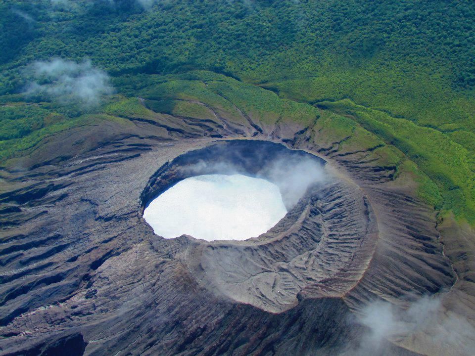
Poas Volcano
Latitude: 10.20°N;
Longitude: 84.23°W;
Altitude: 2687 m above sea level.
Current Activity Level: Warning
Possible events:
Small eruptions, gush or geyser, significant emission of gas, increase in temperature (incandescence), seismic swarms or volcanic tremors, slight inflation-extension of the volcanic edifice.
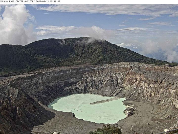
The volcanic tremor remains quite unstable, showing an increase between the end of the previous week and the middle of this week. On the 21st, a small hydrothermal eruption was recorded at dawn. In addition to the frequent low-frequency volcanic earthquakes regularly recorded, a very low frequency (VLP) and large amplitude earthquake was recorded on August 24. Geodetic observations show a slight contraction and subsidence of the volcanic massif. The previous week, the SO2 flux showed a value of 152 ± 112 t/d. Over the past month, the SO2 flux has not fluctuated significantly. The gas ratios measured in the plume remain within normal ranges with weekly averages of SO2/CO2 = 0.69 ± 0.09 and H2S/SO2 < 0.01, values similar to the previous week. The concentration of SO2 in the ambient air around the visitors’ gazebo remains low to moderate with a weekly maximum of 3.4 ppm and an average of 0.2 ppm. The lake level has dropped by approx. 20 cm in a week.
Turrialba Volcano
Latitude: 10.02°N;
Longitude: 83.76°W;
Altitude: 3325 m above sea level.
Current Activity Level: Warning
Possible events:
Small eruptions, significant gas emission, temperature increase (incandescence), seismic swarms or volcanic tremors, slight inflation-extension of the volcanic edifice.
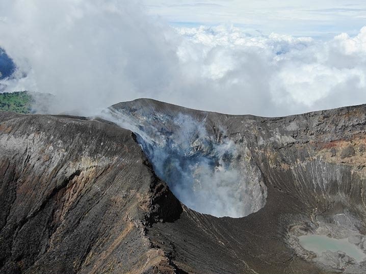
The seismicity remains in slight decrease with the appearance of seismic signals, dominated by low frequency signals of the LP type followed by tremors of very short duration. Geodetic measurements show deflation (subsidence and contraction) in the Irazú and Turrialba volcanoes. The gas ratios measured in the Turrialba plume are similar to the previous week with weekly averages of CO2/SO2 = 9.9 ± 0.8 and H2S/SO2 = 0.24 ± 0.02. The SO2 flux over the past week was 200 ± 126 t/d and showed no major changes over the past month.
Irazu Volcano
Latitude: 9.98°N;
Longitude: 83.85°W;
Altitude: 3427 m above sea level.
Current activity level: Calm
Possible events:
tectonic earthquakes, occasional low frequency earthquakes, hydrothermal activity (fumaroles, diffuse gas, hot springs, etc.).
Earthquakes continue to be recorded in the region northwest of Irazú, although in much lower numbers than the previous week, along the Río Sucio fault. The main landslide in the Las Torres area continues to move slowly without accelerating. Monitoring of degassing on the northern flank of the volcano indicates that the CO2 concentration as well as the CO2/H2S ratio remain stable.
Source : Ovsicori
Photos : Raul Mora / RSN / UCR , Ovsicori , , G. Avard / Ovsicori , Ovsicori .