September 11 , 2021.
Indonesia , Merapi :
Mount Merapi Activity Report, September 3-9, 2021
OBSERVATION RESULT
Visual
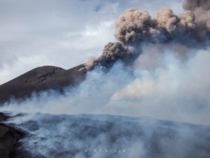
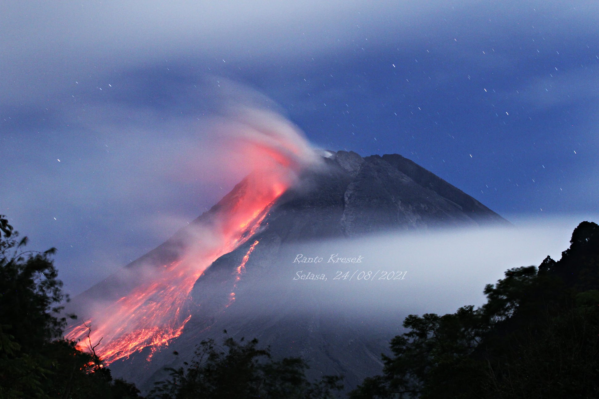
The weather around Mount Merapi is generally sunny in the morning and evening, while it is foggy in the afternoon and evening. White, weak to thick, low pressure, 200m high smoke was observed from the Mount Merapi observation post in Kaliurang on September 7, 2021 at 06:00 WIB.
This week, there was 1 hot cloud avalanche with an estimated slide distance of 2000 m to the southwest. Lava avalanches have been observed 129 times to the southwest with a maximum slide distance of 2000 m.
It was observed that there were morphological changes in the southwest lava dome and the central dome, namely the height of the southwest dome increased by about 5 m and the central dome increased by approximately 1 m wide. The volume of the southwest lava dome is 1,550,000 m3 and the central dome is 2,854,000 m3.
Seismicity
This week, the seismicity of Mount Merapi showed:
1 hot cloud avalanche earthquake (AP),
2 shallow volcanic earthquakes (VTB),
286 low frequency earthquakes (LF),
20 multi-phase earthquakes (MP),
1,491 avalanche earthquakes (RF),
561 emission earthquakes (DG),
4 tectonic earthquakes (TT).
LF-type seismicity this week is higher than last week.
Deformation
The deformation of Mount Merapi which was monitored using EDM and GPS this week showed no significant changes.
Rain and lahars
This week, there have been no reports of rain, lahars or additional flow in the rivers that originate on Mount Merapi.
Conclusion
Based on the results of visual and instrumental observations, it is concluded that:
The volcanic activity of Mount Merapi is still quite high in the form of effusive eruption activity. The status of the activity is defined in the “SIAGA” level.
Source : BPPTKG
Photos : @ilhamm_ska via Alicja Szojer , Ranto Kresek.
Iceland , Geldingadalur / Fagradalsfjall :
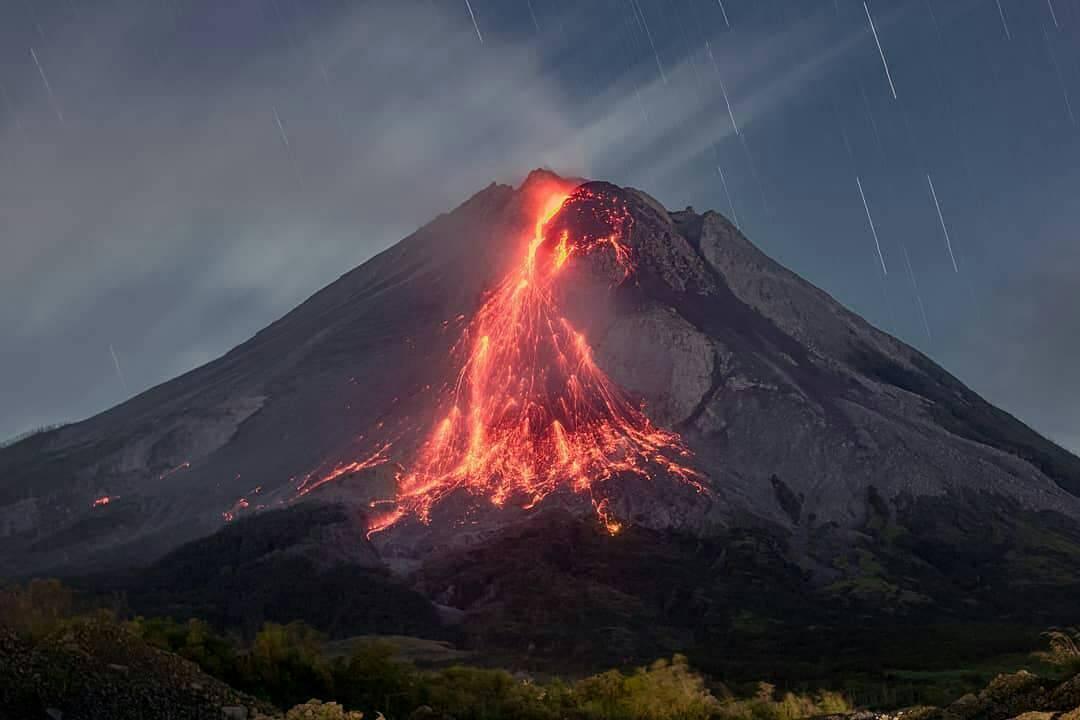
“Something is happening there, because gas is streaming from the crater, but I don’t dare assert what’s happening,” Þorvaldur Þórðarson, professor of volcanology at the University of Iceland, tells mbl.is, speaking of the eruption by Fagradalsfjall mountain, Southwest Iceland, which began March 19.
The behavior of the eruption changed last Thursday, as reflected on volcanic tremor charts. Since then, there has been very limited volcanic activity in the crater. Tuesday morning, though, lava was visible in the crater.
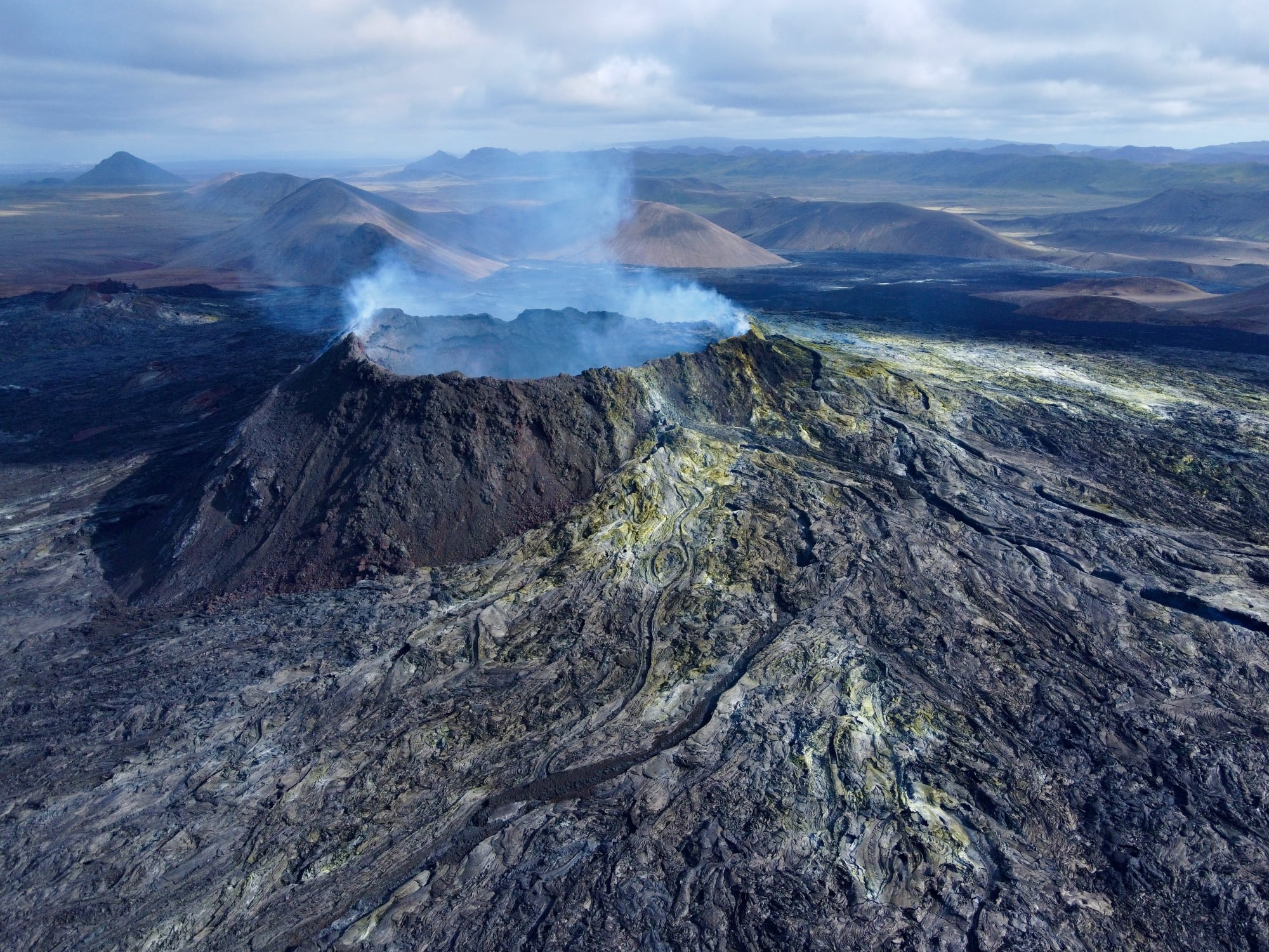
“Degassing tells us that magma is present at relatively limited depth, and there must be new magma coming in,” Þorvaldur states. It appears, he adds, that something is delaying the magma from reaching the surface. Such blockage could possibly suffice to stop the eruption. Still, he believes it is premature to declare the eruption over.
Magma still appears to be simmering in the crater It is premature to announce the end of the Geldingadalur eruption, although there has been a hiatus since Thursday. Gas is still flowing from the crater and the magma seems to be simmering and seeping into it in the darkness of the night. This is the longest continuous hiatus in the eruption since it began on March 19, but this summer there was a five-day hiatus.
Source : icelandmonitor.mbl.is , RUV .
Photo : Gabriele Formentini
Alaska , Great Sitkin :
52°4’35 » N 176°6’39 » W,
Summit Elevation 5709 ft (1740 m)
Current Volcano Alert Level: WATCH
Current Aviation Color Code: ORANGE
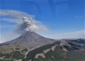
The effusion of lava continues at Great Sitkin. A satellite radar image from September 9 shows that the lava is starting to advance through a gap in the southern rim of the summit crater. The lava dome currently has dimensions of about 1100 m (3600 ft) east-west and about 860 m (2820 ft) north-south, and is 25–30 m (82–98 ft) thick. Seismicity remains elevated with small earthquakes consistent with lava effusion continuing. Elevated surface temperatures, and sulfur dioxide and steam emissions were observed in satellite data over the past week. No explosive activity or ash emissions have been detected in seismic, infrasound and satellite data.
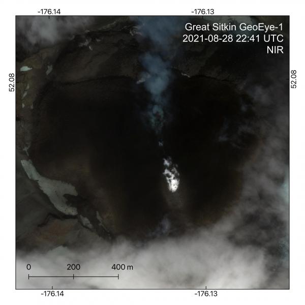
The growing lava dome at Great Sitkin Volcano is visible in this August 28, 2021, GeoEye-1 near-infrared (NIR) image. A steam plume emanates from the dome center where slight incandescence (red) is visible. The dome is now approximately 1040 m by 760 m and just starting to reach the western and southern summit crater walls. The lava dome volume is estimated at 16 million cubic meters.
There is no indication of how long lava effusion will continue during the current eruption, and it is possible that explosive activity could occur with little or no warning.
Great Sitkin Volcano is monitored by local seismic and infrasound sensors, satellite data, web cameras, and remote infrasound and lightning networks.
.
An Information Statement about the current period of lava eruption was issued earlier today and provides more details about the ongoing eruption. It includes a recap of activity over the past several months, a prognosis regarding future activity, and a discussion of the related hazards. It has been delivered via email to subscribers of the USGS Volcano Notification System and is also available on the AVO web page at https://www.avo.alaska.edu/activity/GreatSitkin.php
Source : AVO
Photo : Dietterich, Hannah / AVO-USGS. Ward, Dave .
Philippines , Taal :
TAAL VOLCANO BULLETIN 11 September 2021 8:00 AM
In the past 24-hour period, the Taal Volcano Network recorded forty-eight (48) volcanic earthquakes, including thirty-six (36) volcanic tremor events having durations of two (2) to ten (10) minutes, ten (10) low-frequency volcanic earthquakes, two (2) hybrid events, and low-level background tremor that has persisted since 7 July 2021 .
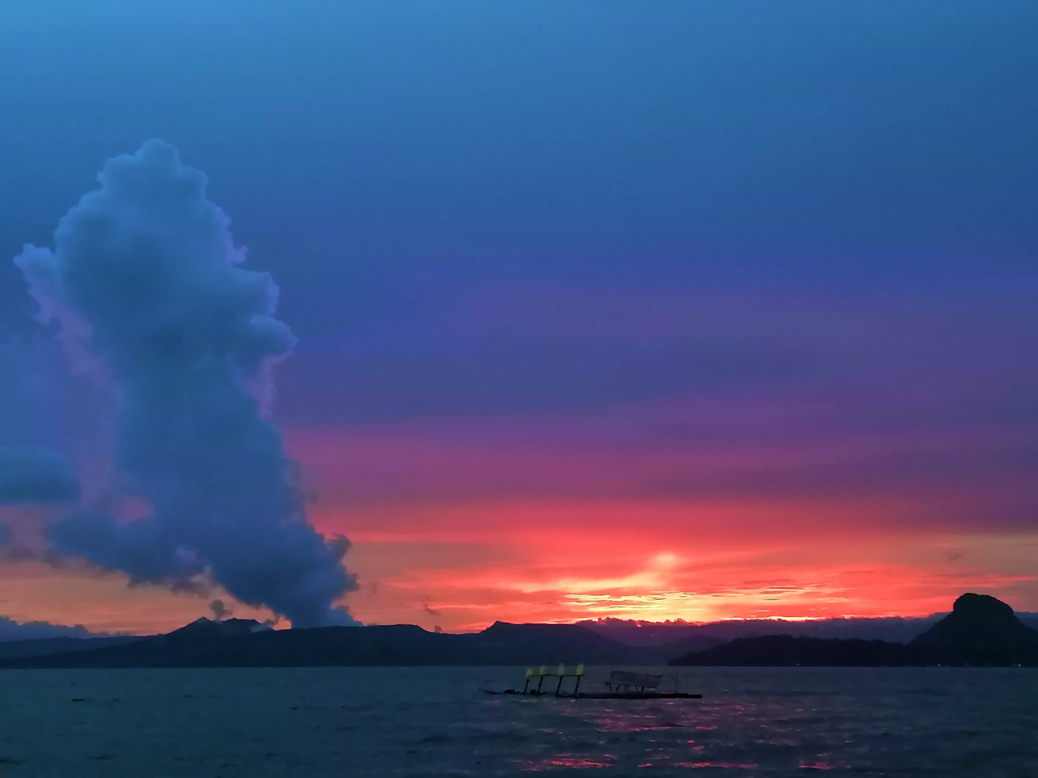
Activity at the Main Crater was dominated by upwelling of hot volcanic fluids in its lake which generated plumes 900 meters tall that drifted northeast. Sulfur dioxide (SO2) emission averaged 9,835 tonnes/day on 10 September 2021. Based on ground deformation parameters from electronic tilt, continuous GPS and InSAR monitoring, Taal Volcano Island has begun deflating in April 2021 while the Taal region continues to undergo very slow extension since 2020.
Source : Phivolcs
Photo : Paleny Paleny.
Ecuador , Reventador :
DAILY REPORT OF THE STATE OF THE REVENTADOR VOLCANO, Friday September 10, 2021.
Information Geophysical Institute – EPN.
Surface activity level: High, Surface trend: No change.
Internal activity level: Moderate, Internal trend: No change.
Seismicity: From September 09, 2021, 11:00 a.m. to September 10, 2021, 11:00 a.m.
Explosions (EXP): 72 events
Long period type events (LP): 66
Tremors of emissions (TREMI): 16
Harmonic Tremors (TRARM): 3.

Rains / lahars: Rains were recorded in the area which did not generate lahars.
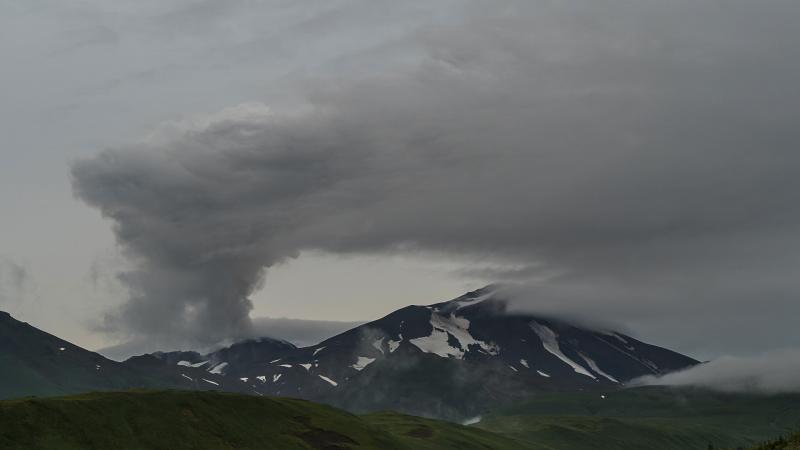
Emission / ash column: In the afternoon of yesterday, several ash emissions were observed in a north and west direction, heights approaching 700 and 1000 meters above the crater level. The Washington VAAC reported 4 alerts of emissions observed by the satellites, their direction varied between the Northwest and the West, the heights did not exceed 1000 meters above the level of the crater
Other monitoring parameters: No thermal alert has been recorded by the satellites for this volcano.
Observations: In the afternoon and night of yesterday, the volcano was largely clear, allowing to observe the emissions already described. At night, an incandescence was observed in the crater as well as the rolling of boulders along the northeast flank of the volcano. Today, the volcano remained cloudy.
Alert level: Orange.
Source et photo : IG-EPN.
Mexico , Popocatepetl :
September 10, 11:00 a.m. (September 10, 4:00 p.m. GMT)
During the last 24 hours, according to the monitoring systems of the Popocatépetl volcano, 130 exhalations accompanied by water vapor, volcanic gases and a low ash content have been identified. In addition, 769 minutes of low amplitude tremors have been identified, as well as an explosion recorded today at 5:19 am.

Since this morning and at the time of this report, the crater has been observed with a slight emission of water vapor, gas and slight amounts of ash in a southwest direction.
CENAPRED recommends NOT TO APPROACH the volcano and especially the crater, because of the danger of falling ballistic fragments and, in the event of heavy rains, to stay away from the bottom of the ravines because of the danger. mudslides and debris.
The Popocatépetl volcanic traffic light is in PHASE 2 YELLOW.
Source et photo : Cenapred .