
July 25 , 2021 .
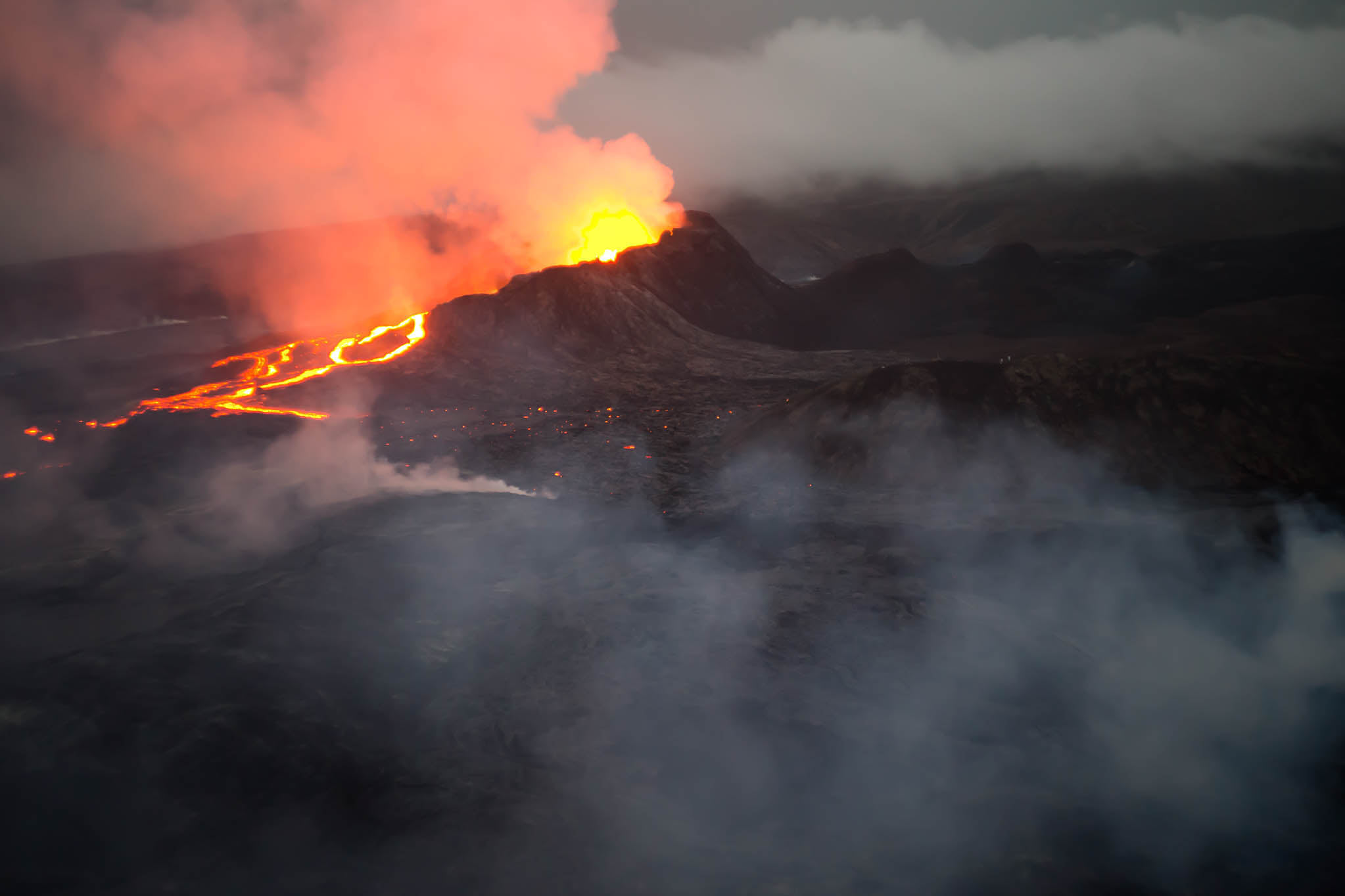
Iceland , Geldingadalur / Fagradalsfjall :
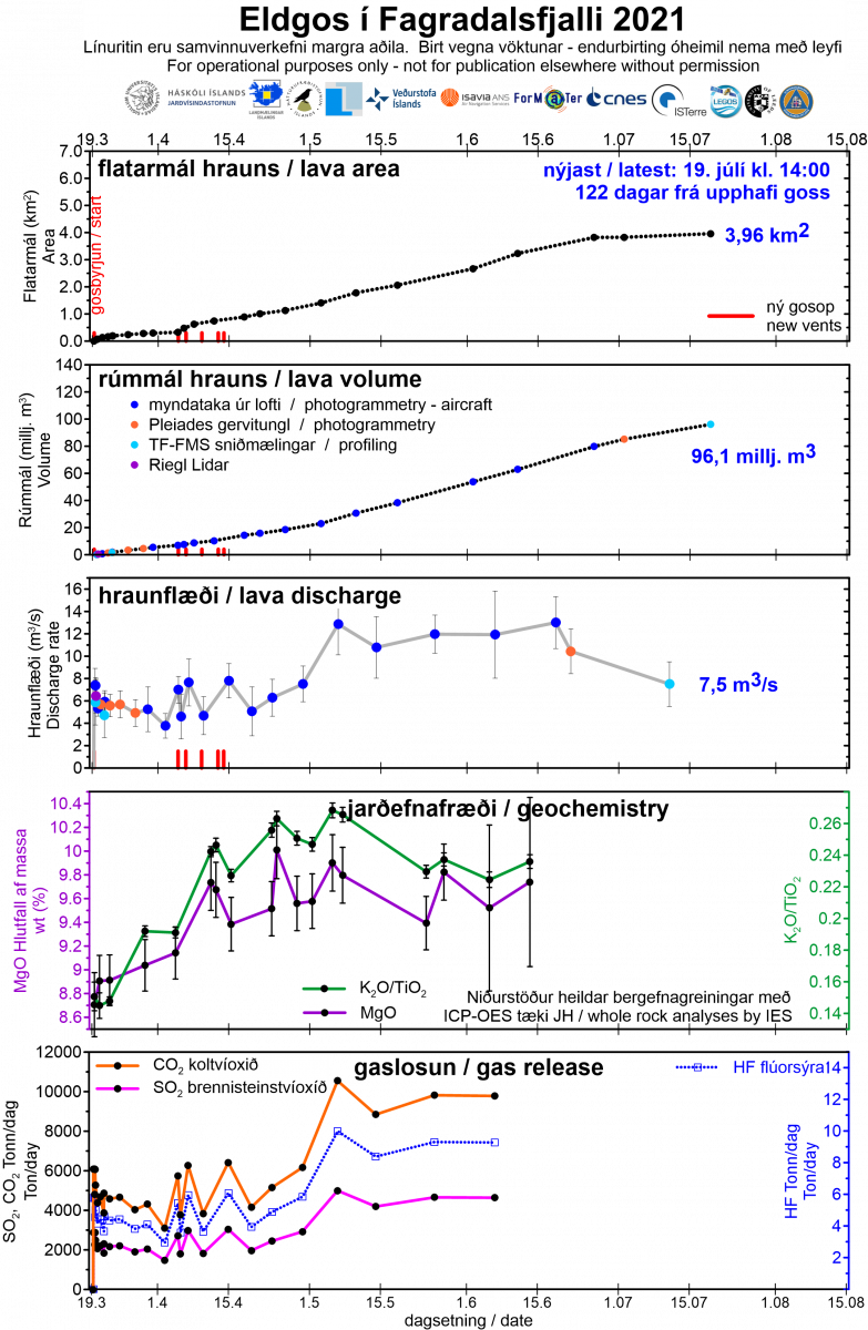
July 22, 2021, Lava flow measurements.
Further measurements were taken on Monday, July 19, when Isavia, TF-FMS, flew and took profile measurements of the lava. In addition, data from the Pléiades satellite of July 2 has been received. Terrestrial models were made based on these measurements and they are compared to the data from June 26.
The average lava flow over the period June 26 to July 2 (6 days) was just over 10 m3 / s but for the period July 2 to 19 (17 days) the average flow is 7.5 m3 / s.
Volcanic activity changed at the end of June. Then the activity began to fluctuate between periods of strong lava flow and periods of calm in between. Current measurements show that the lava flow has decreased significantly. The eruption is therefore clearly on the decline.
The lava flow is now 96 million cubic meters in size and has an area of just under 4 square kilometers. The increase in area has been very small over the past three weeks, as lava has mainly accumulated in the Meradalir valleys and on the western slope of these. During the past two weeks, no lava has flowed in Geldingadalur, Nátthaga and Syðri Meradalir.
Lava flow preview (updated July 22)
After the change at the end of June, it is quite normal to divide the eruption into four periods:
The first period lasted about two weeks and was characterized by a fairly regular lava flow, averaging around 6 m3 / s.
The second period, which also lasted two weeks, was characterized by the opening of new fractures north of the original craters. The lava flow was quite variable, of the order of 5 to 8 m3 / s.
The third period lasted two and a half months and ended at the end of June. The lava flow was for the most part fairly stable, around 12 m3 / s. Lava flowed in Geldingadalur, Meradalur or Nátthaga.
The fourth period began at the end of June. It is characterized by fluctuating activity. When the lava flow is in full swing, it looks similar to what it was in the third period, but then there are long stretches with little to no lava flow. The July measurements show that the average flow is now down sharply. It is 7.5 m3 / s and therefore only 60 to 65% of what it was in May and June.
The Fagradalsfjall eruption is in many ways different from the eruptions we have witnessed in recent decades. Most eruptions originate in magma chambers under major volcanoes, where the pressure in the chamber and its size seem to largely determine the size and duration of the eruption.
In Fagradalsfjall, it seems to be a little different. It can be seen that the inflow veins and its properties largely determine the flow of magma. The open channel was relatively narrow and long (reaching a depth of about 17 km) and carrying capacity was limited. An increase in lava flow over time for the first six weeks indicates that the channel has widened somewhat over time, possibly due to erosion of its walls.
Over the past three weeks the flow has decreased, indicating that the pressure in the system is now decreasing. This could be a sign that the second half of the eruption is starting to subside. However, it is too early to try to predict how long this eruption will last.
Size :
The best way to estimate the size of the Fagradalsfjall eruption is to map the lava and calculate its volume at any given time. This gives an average lava flow between measurements. The volume of lava at any given time and the lava flow are shown in the accompanying graphics, in addition to which the results of the chemical analysis of the magma and the calculated gas emissions of the eruption are displayed.
Source : Eldgos í Fagradalsfjalli | Jarðvísindastofnun – Institute of Earth Sciences (hi.is)
Photo : Adam Kaczuba
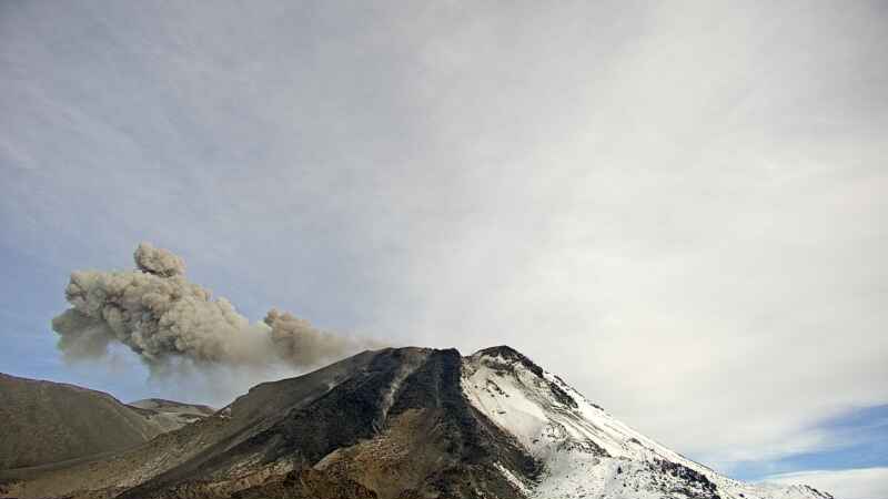
Chile , Nevados de Chillan :
Special Report on Volcanic Activity (REAV), Ñuble region, Nevados de Chillán volcanic complex, July 24, 2021, 1:00 p.m. local time (Continental Chile).
The National Service of Geology and Mines of Chile (Sernageomin) publishes the following PRELIMINARY information, obtained thanks to the monitoring equipment of the National Volcanic Monitoring Network (RNVV), processed and analyzed at the Volcanological Observatory of the Southern Andes ( Ovdas):
On Saturday July 24, at 12:07 local time (16:07 UTC), the monitoring stations installed near the Nevados de Chillán volcanic complex recorded an earthquake associated with fluid dynamics (long period type) in the volcanic system with a value displacement reduced by 593 cm2. After 12:24 local time (16:24 UTC), another earthquake of similar characteristics was recorded with a reduced displacement value of 51 cm2.
The characteristics of the earthquake after its analysis are as follows:
ORIGINAL TIME: 12:07 p.m. local time (16:07 UTC)
LATITUDE: 36.856 ° S
LONGITUDE: 71.372 ° W
DEPTH: 1.1 km
REDUCED DISPLACEMENT: 593 (cm2)
ACOUSTIC SIGNAL: 4.15 Pascals (Pa) reduced to one km
The characteristics of the surface activity are as follows:
MAXIMUM HEIGHT OF THE COLUMN: 400 meters above the point of emission
DISPERSAL DIRECTION: South-East (S-E)
OBSERVATIONS:
The volcanic technical alert remains at the Yellow level.
Source : Sernageomin.
Photo : Segemar.
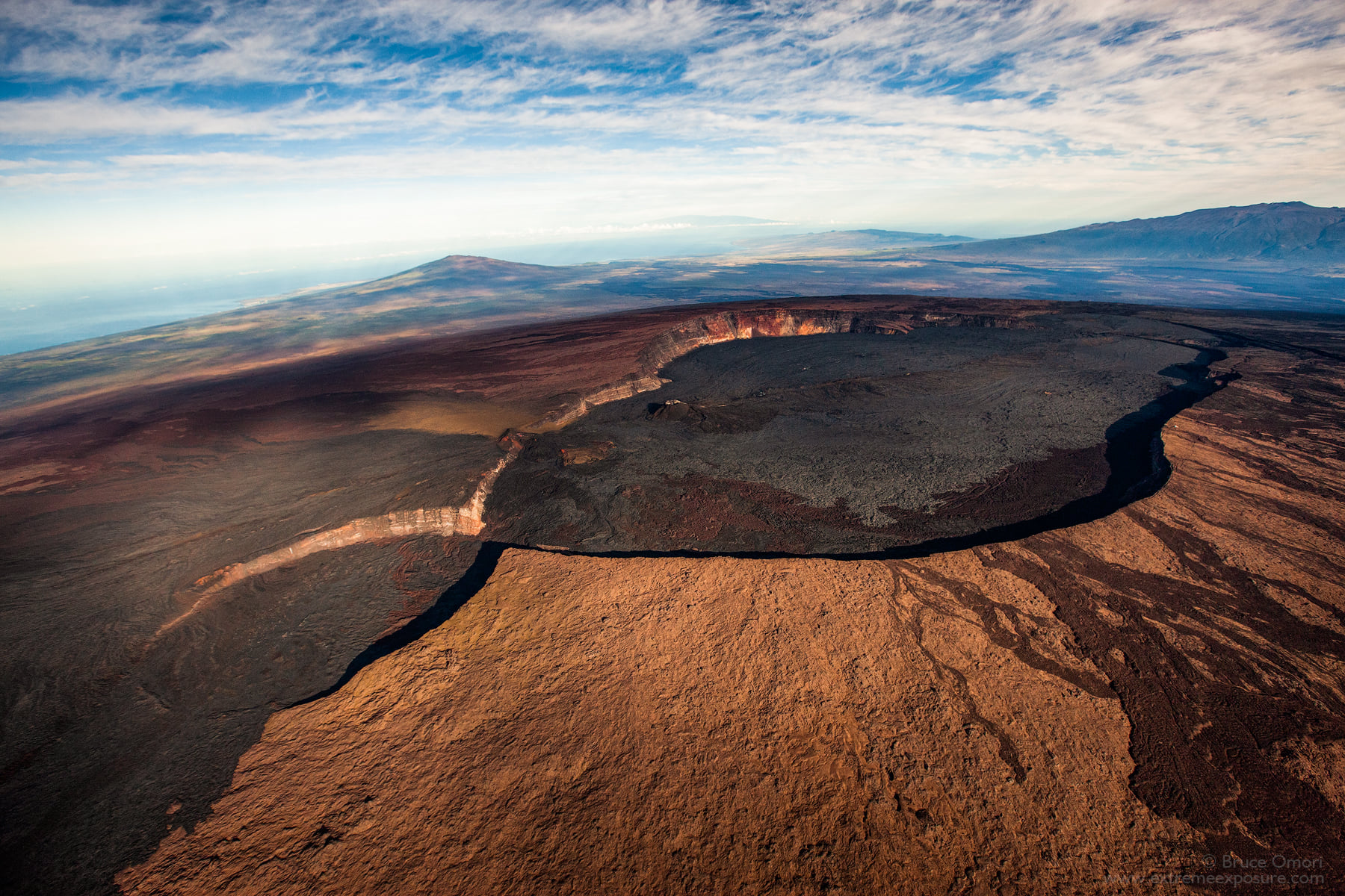
Hawaii , Mauna Loa :
19°28’30 » N 155°36’29 » W,
Summit Elevation :13681 ft (4170 m)
Current Volcano Alert Level: ADVISORY
Current Aviation Color Code: YELLOW
Activity Summary:
Mauna Loa Volcano remains in a state of low-level unrest. Rates of seismicity at the summit remain slightly above long-term background levels. Monitoring of ground deformation, gas discharge and visual monitoring show no significant changes.
Observations:
During the past week, HVO seismometers captured 38 small-magnitude (below M2.5) earthquakes beneath the summit and upper flanks of Mauna Loa. The majority of these earthquakes occurred at shallow depths less than 8 kilometers (5 miles) below sea level.
Ground deformation, measured using Global Positioning System (GPS) measurements, confirm that the surface of the volcano has not moved appreciably over the past week.
Gas concentrations and fumarole temperatures at both the summit crater and Sulphur Cone on the Southwest Rift Zone show no unusual activity.
Finally, web-cameras showed no changes at Mauna Loa summit and on its lower flanks over the past week.
Source : HVO
Photo : Bruce Omori .
Mexico , Popocatepetl :
July 24, 11:00 a.m. (July 24, 4:00 p.m. GMT)
During the last 24 hours, thanks to the monitoring systems of the Popocatépetl volcano, 72 exhalations have been identified, some of which were accompanied by water vapor and volcanic gases.
Likewise, at 11:18 p.m. yesterday, a minor explosion was recorded which threw incandescent fragments on the northern slope and produced an ash column approximately 800 m high, which dispersed to the northwest.
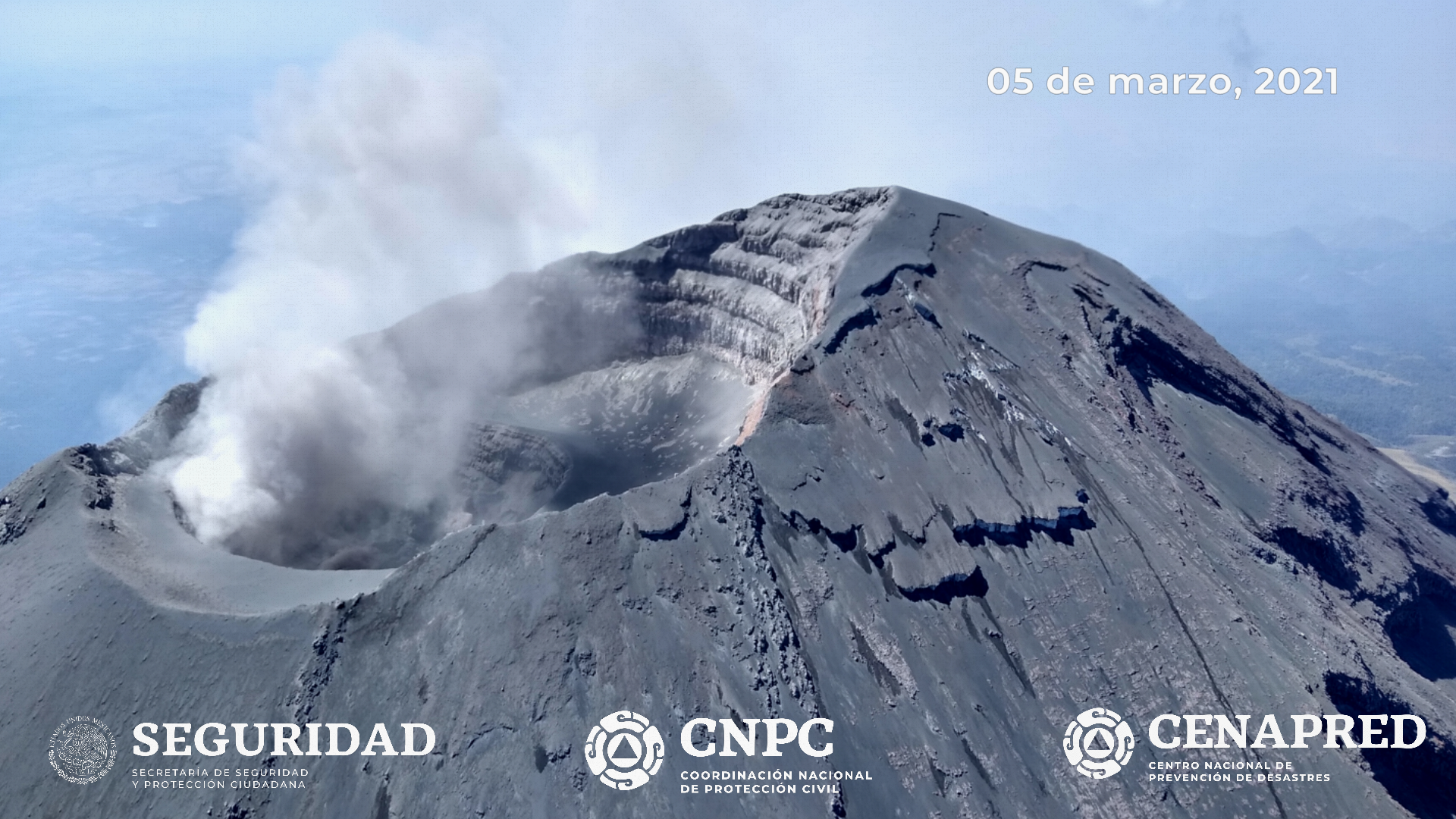
In addition, yesterday at 2:27 p.m., a volcano-tectonic earthquake with a calculated magnitude of 1.5 was recorded.
At the time of this report the visibility towards the volcano is complete. A small emission of steam and gas is observed in a westerly direction.
CENAPRED recommends NOT TO APPROACH the volcano and especially the crater, because of the danger of falling ballistic fragments and, in the event of heavy rains, to stay away from the bottom of the ravines because of the danger. mudslides.
The Popocatépetl volcanic traffic light is in PHASE 2 YELLOW.
Source et photo : Cenapred .
Kamchatka , Karymsky :
VOLCANO OBSERVATORY NOTICE FOR AVIATION (VONA)
Issued: July 23 , 2021
Volcano: Karymsky (CAVW #300130)
Current aviation colour code: ORANGE
Previous aviation colour code: orange
Source: KVERT
Notice Number: 2021-73
Volcano Location: N 54 deg 2 min E 159 deg 26 min
Area: Kamchatka, Russia
Summit Elevation: 1486 m (4874.08 ft)
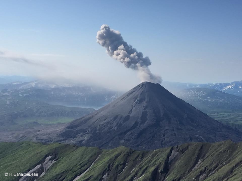
Volcanic Activity Summary:
A moderate eruptive activity of the volcano continues. According to satellite data by KVERT, an emission of ash continues continuously. Explosions send ash up to 1.5 km a.s.l. and ash plume is extending for 50 km to the eastnortheast of the volcano.
This activity continues. Ash explosions up to 19,700-23,000 ft (6-7 km) a.s.l. could occur at any time. Ongoing activity could affect low-flying aircrafts.
Volcanic cloud height:
1500 m (4920 ft) AMSL Time and method of ash plume/cloud height determination: 20210723/0250Z – Himawari-8
Other volcanic cloud information:
Distance of ash plume/cloud of the volcano: 50 km (31 mi)
Direction of drift of ash plume/cloud of the volcano: ENE / azimuth 63 deg
Time and method of ash plume/cloud determination: 20210723/0250Z – Himawari-8
Source : Kvert .
Photo : N. Balakhontseva. ( 2018).


No comment yet, add your voice below!