May 07 , 2024.
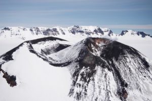
Indonesia , Ibu :
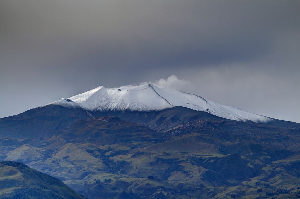
Mount Ibu erupted on Monday, May 6, 2024, at 3:12 p.m. WIT. The height of the eruptive column was not observed. The eruption was recorded on a seismograph with a maximum amplitude of 28 mm and a duration of 102 seconds.
Seismicity observation:
6 eruption earthquakes with an amplitude of 15 to 28 mm and a seismic duration of 20 to 296 seconds.
70 emission earthquakes with an amplitude of 2 to 26 mm and earthquake duration of 4 to 50 seconds.
6 harmonic tremors with an amplitude of 2 to 8 mm and an earthquake duration of 76 to 305 seconds.
328 shallow volcanic earthquakes with amplitude of 2 to 14 mm and duration of 4 to 14 seconds.
2 deep volcanic earthquakes with an amplitude of 3 mm, and an earthquake duration of 5 seconds.
15 local tectonic earthquakes with an amplitude of 2 to 17 mm, and the duration of the earthquake was 32 to 106 seconds.
Recommendation
1. Communities around Mount Ibu and visitors/tourists should not carry out activities within a radius of 2.0 km with a sectoral extension of 3.5 km towards the crater opening in the northern part of the active crater from Mount Ibu.
2. In the event of ash falling, people who carry out activities outside the house are advised to protect their nose, mouth (mask) and eyes (glasses).
Source: Magma Indonésie.
Photo : Lexi Djangu Trekker
Hawaii , Kilauea :
Monday, May 6, 2024, 9:53 AM HST (Monday, May 6, 2024, 19:53 UTC)
19°25’16 » N 155°17’13 » W,
Summit Elevation 4091 ft (1247 m)
Current Volcano Alert Level: ADVISORY
Current Aviation Color Code: YELLOW
Activity Summary:
Kīlauea volcano is not erupting. Seismicity continues beneath the upper East Rift Zone. Inflation continues in the caldera south of Halemaʻumaʻu. This activity is similar to conditions at Kīlauea prior to last week’s period of heightened unrest.
Summit and upper East Rift Zone Observations:
Earthquake counts have decreased to approximately 70 earthquakes the past 24 hours compared to over 350 per day at the peak of the unrest. Earthquake locations remain focused primarily from the southeast side of Kaluapele (Kīlauea caldera) beneath Keanakākoʻi crater extending to the intersection with Hilina Pali Road. Seismicity has returned to the caldera south of Halemaʻumaʻu with approximately 10 earthquakes in that region in the past 24 hours. Earthquake depths have averaged 2-4 km (1.2-3.1 miles) beneath the surface, and magnitudes have not exceeded M2.5 in the past 24 hours, with the majority below M2.0.

HVO staff performed some routine maintenance on the V1cam at Kīlauea summit. This webcam provides the livestream that operates 24/7, and has helped track recent eruptions in the summit caldera.
Ground deformation continues beneath Halemaʻumaʻu and the south side of Kalaupele and Keanakākoʻi crater following a brief cessation related to a local deflation-inflation (DI) event beneath Halemaʻumaʻu. The Uēkahuna tiltmeter began recording inflation at approximately 4:30 AM yesterday, which has continued into this morning. The Sandhill tiltmeter is once again recording accelerated uplift at rates similar to those prior to and during last week’s seismic unrest.
Sulfur dioxide (SO2) gas emission rates remain low. An SO2 emission rate of approximately 62 tonnes per day was recorded on May 2nd.
Rift Zone Observations:
All seismic activity on the East Rift Zone is confined to the upper East Rift Zone, with no significant earthquakes occurring past the Pauahi Crater. At this time, seismicity south of Kaluapele and in Kīlauea’s Southwest Rift Zone remains relatively low. Measurements from continuous gas monitoring stations downwind of Puʻuʻōʻō in the middle East Rift Zone—the site of 1983–2018 eruptive activity—continue to be below detection limits for SO2, indicating that SO2 emissions from Puʻuʻōʻō are negligible.
Analysis:
The decrease in both seismicity and ground deformation indicates that the pulse of unrest that began on April 27 concluded by noon on May 3. Resumption of heightened seismic unrest could occur at any time, most likely in the upper East Rift Zone, within Kaluapele, or south of Kaluapele.
Source : HVO
Photo : USGS / M. Patrick.
Colombia , Puracé :
Popayan, May 6, 2024, 2:45 p.m.
From the monitoring of the activity of the PURACE VOLCANO – LOS COCONUCOS VOLCANIC CHAIN, the COLOMBIAN GEOLOGICAL SERVICE (SGC), an entity attached to the MINISTRY OF MINES AND ENERGY, reports that:
From yesterday to today, the seismic activity associated with the fracturing of rocks inside the volcanic edifice has maintained a behavior similar to that recorded in previous days. For its part, activity linked to the movement of fluids continues to show an increase in terms of the number of events and energy released. Fracture earthquakes continue to occur beneath the crater of the Puracé volcano and its eastern flank, at depths of up to 3.5 km. The maximum magnitude calculated was 1.6 ML, corresponding to an earthquake recorded yesterday at 11:13 p.m. Seismicity linked to the movement of fluids continues to be concentrated in the crater sector and on its northern flank, at depths less than 1 km.
The recording of very low magnitude earthquakes associated with the rise, installation or movement of magma persists, located under the eruptive centers of Piocollo and Curiquinga, with depths ranging from 1 to 3 km.
Given the meteorological conditions during the period evaluated in this bulletin, the low visibility prevented the observation of the fumarole, which made it impossible to measure the height of the gas column. Ground deformation processes and concentrations of carbon dioxide (CO2) and sulfur dioxide (SO2) gases have not shown changes and their values continue to be above known baselines for this volcano.
The SGC confirms that the alert state of the PURACE VOLCANO continues at ORANGE: volcano with significant changes in the monitored parameters.
Source : SGC
Photo : José M. Arboleda
Iceland , Edley / Reykjanes Peninsula :
Earthquake swarm off Reykjanes Peninsula , 6. May 2024 – 10:42 GMT
An earthquake swarm began last night off the Reykjanes Peninsula, just west of Eldey. Approximately 70 earthquakes were recorded since the swarm began although their number decreased as the night went on.
Just after 9.30pm, an earthquake of magnitude 3.5 was measured about four kilometres west of Eldey. A little over an hour later, another of magnitude 3.2 was recorded.

According to Bjarki Kaldalón Friis, a natural disaster specialist at the Icelandic Meteorological Office, it is not impossible that rising land at Svartsengi has an effect. He emphasises though that earthquakes are common on the Reykjanes ridge.
From February 12 to 18, a series of earthquakes hit the same area, where about a hundred earthquakes were recorded, the largest of magnitude 3.5.
The activity in the volcanic eruption at Sundhnúksgíga seems to be the same as it has been recently, but Bjarki says that seismic activity has increased slightly at the eruption zone.
Source : RUV / Darren Adam.
Photo : Google map
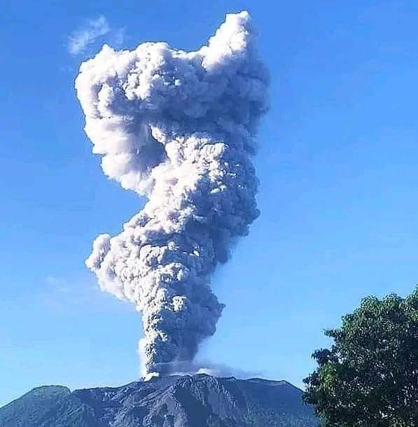
Guatemala , Santiaguito :
Weather conditions: Cloudy.
Wind: North-East.
Precipitation: 2.3 mm.
Activity:
The Observatory reports activity in the Caliente dome, with columns of moderate and abundant degassing continuously in the West and Southwest directions. There were 3 to 5 explosions per hour, accompanied by moderate avalanches producing continuous incandescence above the dome. Moderate to strong explosions raise columns of water vapor and ash to heights of up to 3,900 meters above sea level (13,000 feet) and trigger the descent of pyroclastic flows over short distances that extend along all sides.

This activity causes an accumulation of hot material and free ash around the crater. The detachment of rock blocks from the dome and the edges of the lava flow continues to occasionally generate weak and/or strong avalanches that can be audible several kilometers from the volcano. Activity remains at a high level, so there remains the possibility that with explosions or under the effect of gravity, part of the accumulated materials collapse and pyroclastic flows over long distances are generated towards the South. West, South, South-East and East.
Source : Insivumeh.
Photo : Armando Pineda