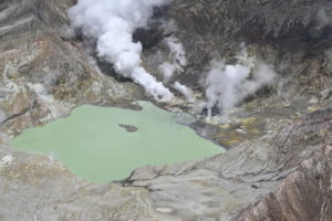
May 06 , 2024.
Indonesia , Ruang :
Press release on the activity of the Ruang volcano from May 6, 2024.
The latest developments in G. Ruang’s activities until May 6, 2024 are as follows:
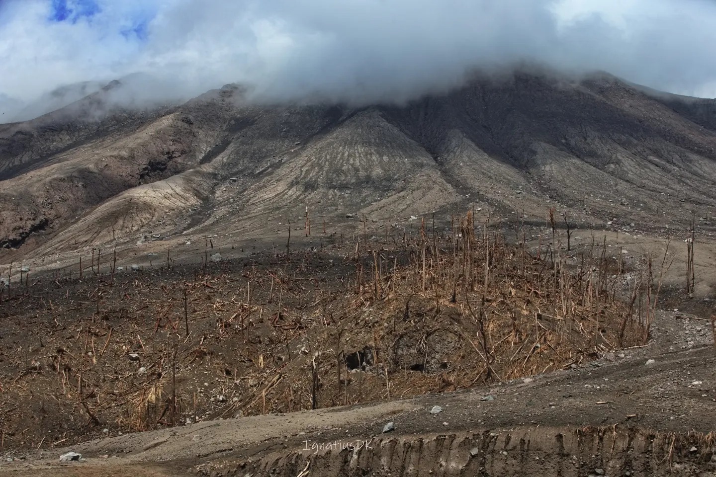
After the explosive eruption on April 17, 2024, eruptive activity decreased. On April 22, 2024 at 09:00 WITA, G. Ruang’s activity level was lowered from level IV (AWAS) to level III (WASPADA).
The seismicity from April 29, 2024 until 24:00 WITA recorded via the RAPS station were: 15 avalanche earthquakes, 237 shallow volcanic earthquakes, 425 deep volcanic earthquakes, 15 local tectonic earthquakes and 6 distant tectonic earthquakes. Crater smoke was observed up to 200 to 1,000 m above the summit with a thick white color. At 17:02 WITA, a weak eruption was observed with smoke coming from the crater up to 1000 m from the summit.
On April 30, 2024 at 01:15 WITA, an eruption occurred, starting with a tremor felt as far away as Tagulandang Island, with a gray, medium-to-thick eruption column tilted toward the North. The height of the eruptive column reached 2000 m above the summit. G. Ruang’s activity level was increased to Level IV (AWAS) at 01:30 WITA, with a recommended danger distance of 6 km radius. At 09:00 WITA, the recommended danger distance was extended to 7 km.
On April 30, 2024 at 02:32 WITA, there was another eruption followed by a roar. The height of the eruption column was not observed due to darkness. It was reported that stone showers occurred at the Ruang PGA post in P. Tagulandang. The eruption lasted until 04:30 WITA. The seismic monitoring equipment on the G. Ruang (RAPS) was damaged. At 08:35 WITA, an eruption was observed accompanied by a flow of hot clouds which reached the sea in the northeast sector of the island. The eruptive column measures ± 5,000 m in height from the summit of the peak, gray to black in color, thick in intensity, oriented towards the East and the South.
On May 3, 2024, new monitoring equipment was installed on Ruang Island (RUA4) at a distance of 2 km from the active crater. This RUA4 station allows you to calculate the current seismic activity.
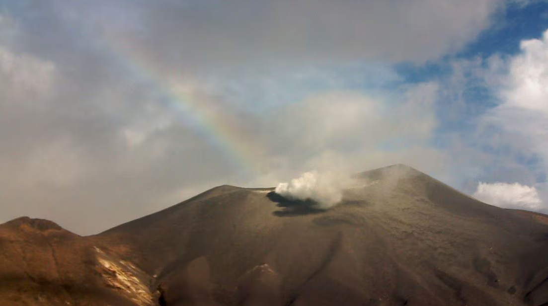
Seismicity from May 1 to 5, 2024 recorded 2 eruption earthquakes, 76 shallow volcanic earthquakes and 16 deep volcanic earthquakes, 4 local tectonic earthquakes, 26 distant tectonic earthquakes and 11 continuous tremors. An eruption occurred on May 1, 2024 at 5:43 p.m. WITA with the height of the ash column observed at ±600 m above the peak. On May 2, 2024, an eruption was observed at 4:12 p.m. WITA and a column of white-gray smoke with a height of 300 m leaned towards the North. In general, the smoke from the crater is white and gray with medium to thick intensity and a height of 100 to 700 m above the crater summit.
Seismicity from May 6, 2024 until 06:00 WITA was recorded as 1 distant tectonic earthquake and continuous tremors are still recorded via station RUA4. Smoke from the crater was observed to be white, thick in intensity, and reaching a height of 100 m above the crater summit.
The smoke is always observed to be white and gray in color with medium to thick intensity and a height of 100 to 700 m above the peak, this always indicates that the activity of G. Ruang is still high.
Current potential hazards include eruptions producing hot clouds, ejections of incandescent material, and exposure to volcanic ash that depend on wind direction and speed, and lahars in heavy rains around Mount Ruang.
Based on the results of visual and instrumental monitoring, the volcanic activity of Mount Ruang is still high and is set at level IV (AWAS).
Source : PVMBG
Photos : PVMBG , Dwikoen Sastro .
Colombia , Puracé :
Popayan, May 5, 2024, 2:45 p.m.
From the monitoring of the activity of the PURACE VOLCANO – LOS COCONUCOS VOLCANIC CHAIN, the COLOMBIAN GEOLOGICAL SERVICE (SGC), an entity attached to the MINISTRY OF MINES AND ENERGY, reports that:
Since yesterday and until the time of publication of this bulletin, the seismic activity associated with the fracture has shown a decrease, while that linked to the movement of fluids presents a slight increase in terms of number of events and energy released, compared to what was recorded in previous days. Earthquakes associated with rock fracturing continue to be located mainly under the crater of the Puracé volcano and on its eastern flank, at depths less than 3 km. The maximum magnitude was 1.9 ML, reached by two earthquakes recorded today at 2:25 a.m. and 4:46 a.m. Seismicity linked to the movement of fluids continues to be concentrated mainly in the crater sector and on its northern flank, at depths less than 0.8 km.
In addition, earthquakes associated with the rise, installation or movement of magma, located under the eruptive centers of Piocollo and Curiquinga, have been recorded, of very low magnitude, with depths ranging from 1.5 to 3.5 km.
The maximum height of the gas column observable between yesterday and today was approximately 300 m, measured from the summit of the volcano and with a direction of dispersion towards the West. Ground deformation processes and concentrations of carbon dioxide (CO2) and sulfur dioxide (SO2) gases have not shown changes and their values continue to be above known baselines for this volcano.
The SGC confirms that the alert state of the PURACE VOLCANO continues at ORANGE: volcano with significant changes in the monitored parameters. Although it is possible that the levels of seismic activity, as well as those of degassing, decrease or oscillate, in the sense of increasing on some days and decreasing on others, this does not imply that the volcano has returned to their normal activity levels. To return to a minor alert state (yellow), a reasonable period of time is required during which all monitored parameters are evaluated and trends that may indicate greater stability are determined. During this time, in the event of an acceleration of processes suggesting an imminent eruption or if the eruption itself occurs, the alert status level will change to Red.
Source et photo : SGC
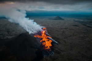
Kamchatka , Sheveluch :
56.64 N, 161.32 E;
Elevation 3283 m (10768 ft), the dome elevation ~2500 m (8200 ft)
Aviation Colour Code is ORANGE
An extrusive-effusive eruption of the volcano continues. A danger of ash explosions up to 6 km (19,700 ft) a.s.l. remains. Ongoing activity could affect low-flying aircraft.
The extrude of the new lava dome Karan-1 on the southwestern slope of the Sheveluch volcano continues. No power explosions of the dome are expected within a month. Ongoing activity could affect low-flying aircraft.
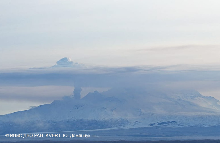
The extrusive-effusive eruption of the volcano continues: a lava is extruded out in the explosive crater of the Young Sheveluch, it is accompanied by powerful gas-steam activity, and sometimes an incandescence of the lava dome. Satellite data by KVERT showed a thermal anomaly over the volcano all week.
On April 26, 2024, a new lava dome Karan-1 appeared on the earth surface on the southwestern slope of the Sheveluch volcano. The extrusive eruption continues, it is accompanied by powerful gas-steam activity and the glow of the dome at night. According to KVERT satellite data, a bright large thermal anomaly in the area of the Karan-1 dome was observed all week.
Source : Kvert
Photo : Yu. Demyanchuk, IVS FÉVRIER RAS, KVERT
Ecuatdor / Galapagos , Fernandina :
DAILY REPORT ON THE ACTIVITY OF THE FERNANDINA VOLCANO. Quito, Sunday May 5, 2024.
From May 4, 2024 11:00:00 to May 5, 2024 11:00:00
Activity level:
Surface: Moderate; Surface trend: No changes
Internal: Moderate; Internal trend: No changes
Other monitoring parameters:
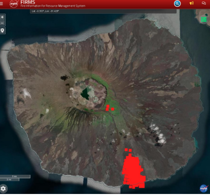
The FIRMS satellite system recorded 122 thermal anomalies over the past 12 hours. On the other hand, over the last 24 hours, the MIROVA-MODIS and MIROVA-VIIRS systems have detected 3 and 4 thermal anomalies respectively.
Observation:
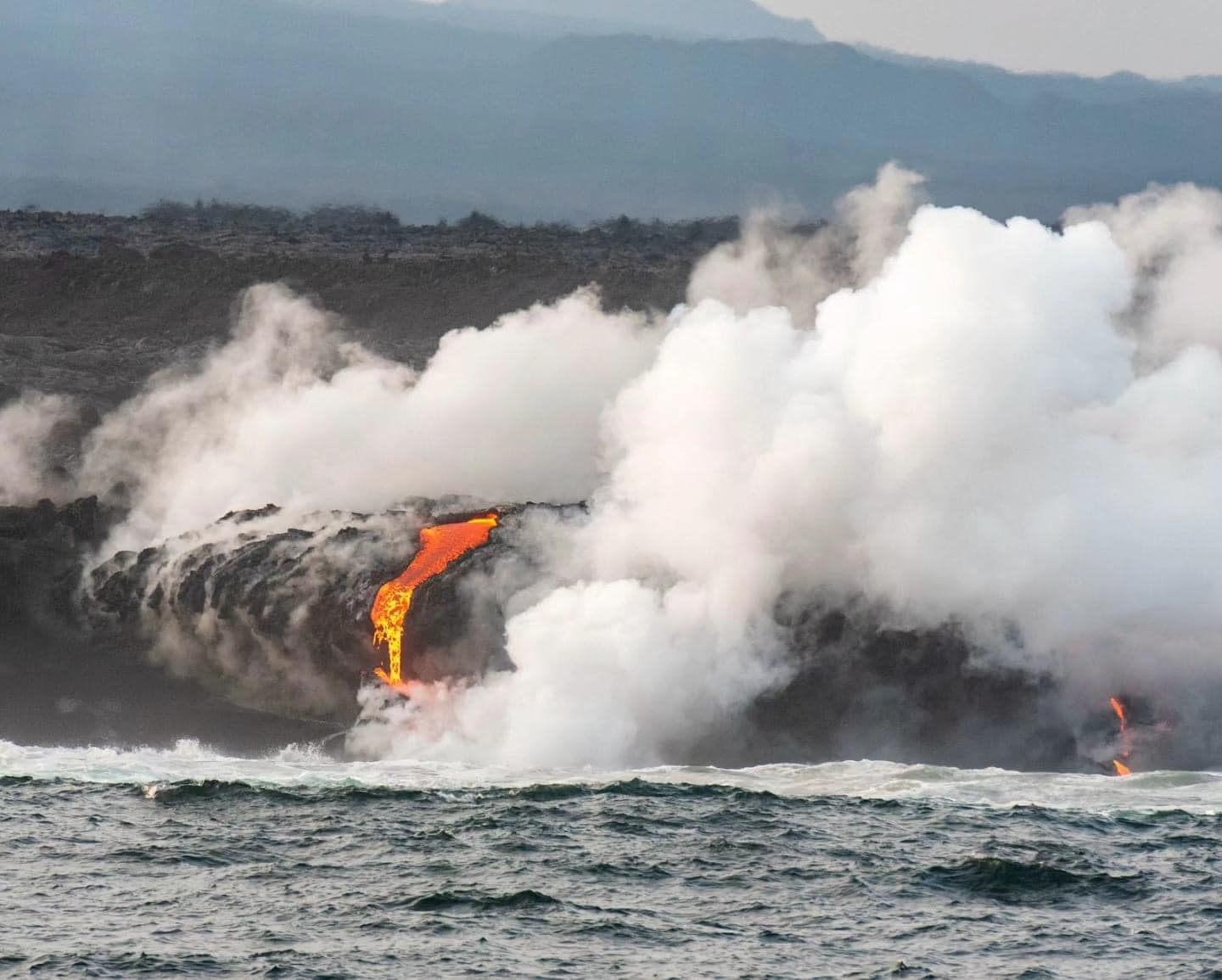
With satellite images from GOES-16, permanent thermal anomalies are observed due to the activity of the volcano. Currently, the lava flows have reached the coast and are in contact with the sea, which allows emissions of water vapor and gas to be observed. It is recommended to take precautions regarding tourism, fishing and research activities, among others.
Source : IGEPN
Photos : IGEPN , Galápagos Naciente.
Costa Rica , Rincon de la Vieja :
Latitude: 10.83
Longitude:-85.324
Altitude: 1,916 meters
Activity observed:
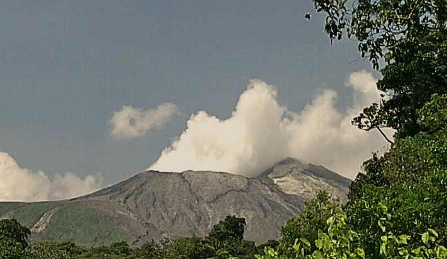
An intense plume of steam continues to be observed emerging from the crater with regular pulses. A very intense tremor is detected, the most energetic in the last five years, characterized by its continuity and a frequency range that oscillates between 0.8 and 8 Hz, despite the fact that geodetic measurements indicate that inflationary activity has decreased over the during the last week. The accumulated deformation on the volcano is the most pronounced recorded since records began in 2017.
Environmental conditions: Light winds towards the South-West.
Activity Level: Caution (3)
Source et photo : Ovsicori.