June 07 , 2021.
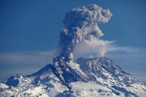
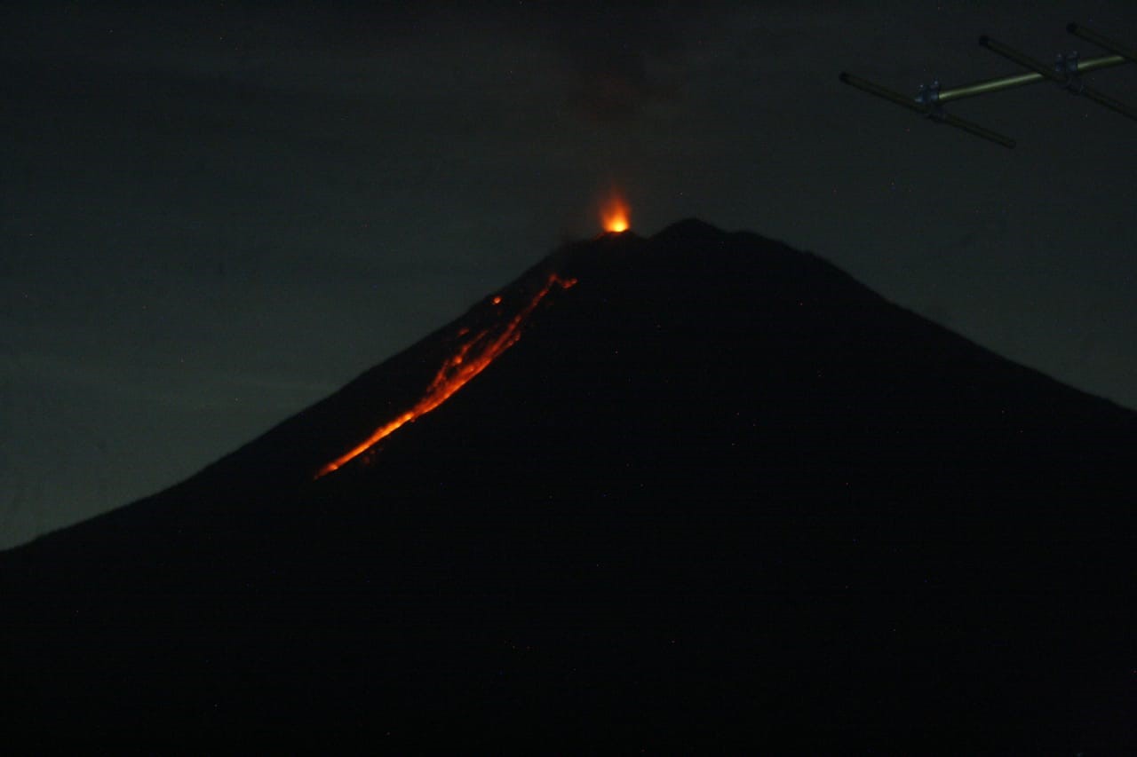
Italy / Sicily , Etna :
Communication on ETNA’s activity, June 6, 2021, 14:26 (12:26 UTC).
The National Institute of Geophysics and Volcanology, Osservatorio Etneo, reports that from around 08:00 UTC, a rapid increase in the mean amplitude values of the volcanic tremor was observed, which currently stands at an average level. The centroid of the volcanic tremor sources remains located in the area of the Southeast Crater at an altitude of about 3000 m. Infrasound activity continues to remain low and infrasound events are localized in the area of the Bocca Nuova crater.
According to the analysis of the images of the surveillance cameras, on the surface no explosive activity is observed at the level of the Southeast Crater.
There is no significant variation in the time series of soil deformation monitoring stations.
Further updates will be communicated shortly.
Source : INGV.
Photo : Boris Behncke.
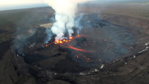
Iceland , Geldingadalur / Fagradalsfjall :
Lava flows over the western protective wall.
Lava started to flow over the western protection wall in the southern Merardalur valley around 1:30 am this morning. The weather bureau’s camera noticed an increase in turbulence and gas emissions from the eruption this morning, and soon after, a flow was seen making its way down the observation hill and finally onto the West protection wall.
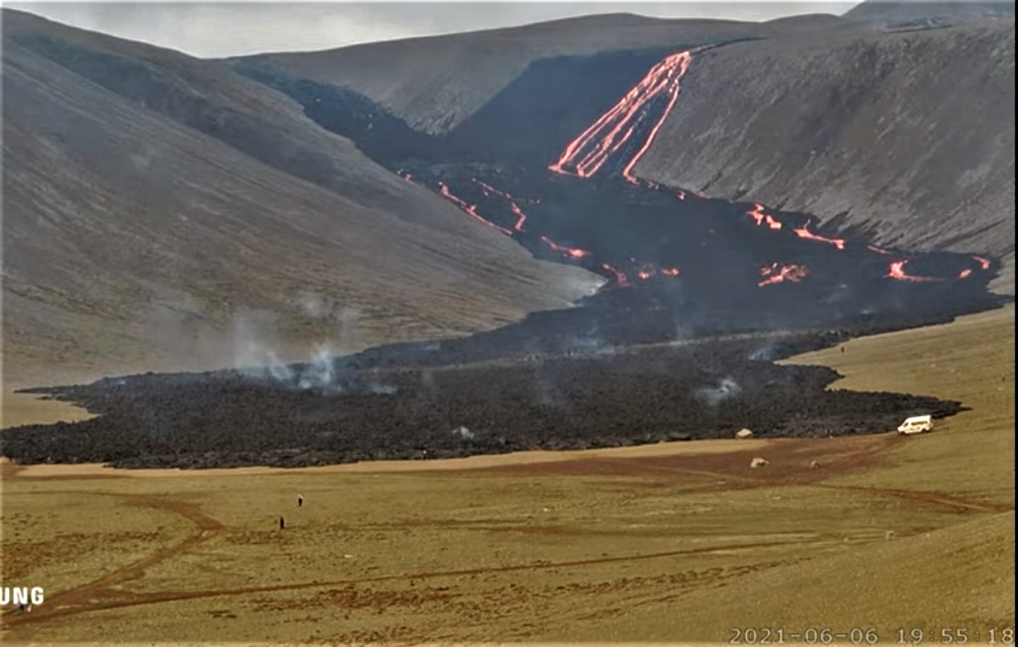
« It’s a rather beautiful flow that just keeps on going, » says Elísabet Pálmadóttir, nature conservation specialist at the Icelandic Meteorological Office. Experts had always expected it to start flowing over both fortifications, but the basins had certainly delayed the lava flow in Nátthaga. “But now it flows into Nátthaga from two places in the southern valleys of Merardalur,” she said.
Source : Vedur is
Photo : UNG.
Philippines , Pinatubo :
PINATUBO VOLCANO BULLETIN: 07 June 2021 08:00 A.M.
Pinatubo Volcano’s monitoring network recorded twenty-five (25) volcanic earthquakes during the 24-hour observation period.
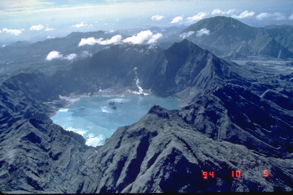
Alert Level 1 (Abnormal) prevails over Pinatubo Volcano, which means that there is low-level unrest that may be related to tectonic processes beneath its edifice and that no imminent eruption is foreseen. Entry into the Pinatubo Crater area must be conducted with extreme caution and should be avoided if possible. Communities and local government units surrounding Pinatubo are reminded to be always prepared for both earthquake and volcanic hazards and to review, prepare and strengthen their contingency, emergency and other disaster preparedness plans. DOST-
PHIVOLCS is closely monitoring the volcano’s condition and any new development will be relayed to all concerned.
Source : Phivolcs .
Photo : GVP , Ray Punungbayan, 1994 (Philippine Institute of Volcanology and Seismology).
Indonesia , Semeru :
VOLCANO OBSERVATORY NOTICE FOR AVIATION – VONA
Issued : June 06 , 2021
Volcano : Semeru (263300)
Current Aviation Colour Code : ORANGE
Previous Aviation Colour Code : orange
Source : Semeru Volcano Observatory
Notice Number : 2021SMR33
Volcano Location : S 08 deg 06 min 29 sec E 112 deg 55 min 12 sec
Area : East java, Indonesia
Summit Elevation : 11763 FT (3676 M)
Volcanic Activity Summary :
Eruption with volcanic ash cloud at 00h00 UTC (07h00 local).
Volcanic Cloud Height :
Best estimate of ash-cloud top is around 13363 FT (4176 M) above sea level, may be higher than what can be observed clearly. Source of height data: ground observer.
Other Volcanic Cloud Information :
Ash cloud moving to north
Remarks :
Seismic activity is characterized by eruption, avalanche and gas emission earthquakes.
Level of activity at Level II (WASPADA). Mount Semeru (3,676 m above sea level) erupts intermittently. There are explosive and effusive eruptions, producing lava flows towards the southern and south-eastern slopes, as well as ejections of incandescent rocks around the summit crater. The last eruption took place on May 14, 2021, the height of the eruption column was not observed.
The volcano is clearly visible until it is covered in fog. The eruption column observed at 400 m was white and gray, oriented towards the south. The weather is sunny to cloudy, the wind is weak in the North, North-East and South.
According to the seismographs of June 6, 2021, it was recorded:
42 eruption / explosion earthquakes
6 emissions earthquakes
1 distant tectonic earthquake
Source : Magma Indonésie , PVMBG.
Photo : pvmbg.
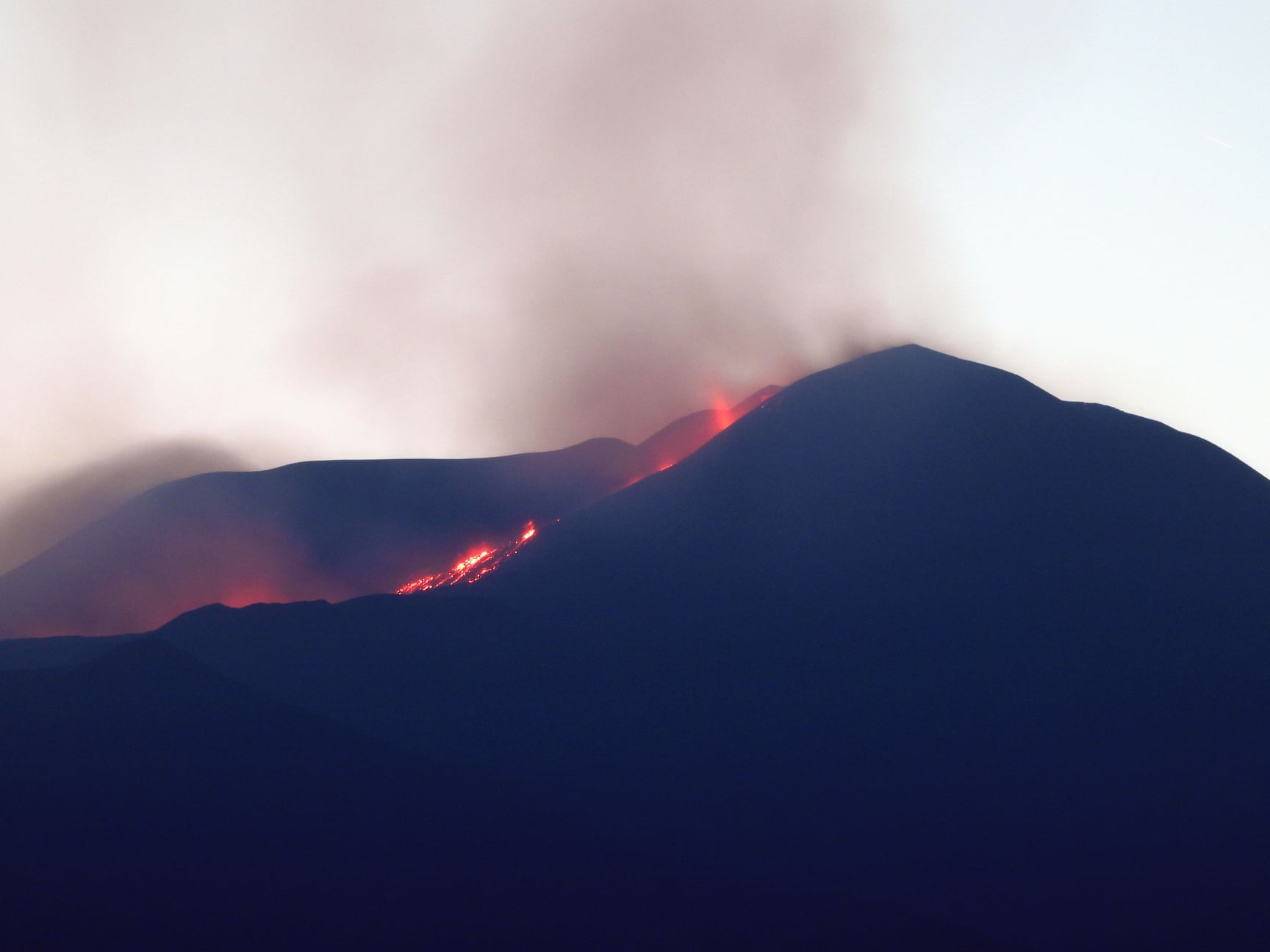
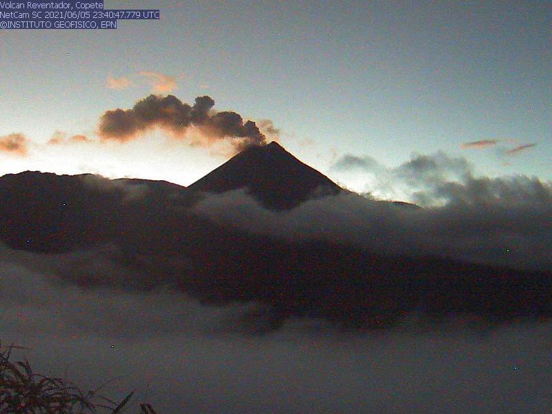
Ecuador , Reventador :
DAILY REPORT OF THE STATE OF THE REVENTADOR VOLCANO, Sunday 06 June 2021.
Information Geophysical Institute – EPN.
Surface activity level: High, Surface trend: increasing.
Internal activity level: Moderate, Internal trend: No change.
Seismicity: From June 05, 2021, 11: 00h to June 06, 2021, 11: 00h:
Explosions (EXP): 10 events
Long period type events (LP): 42
Emission tremor (TREMI): 1
Rains / lahars: Light rains were recorded in the volcano region, without generating lahars.
Emission / ash column: In the afternoon of yesterday, an emission of gas and ash was observed with a height greater than 400 meters in a westerly direction. Additionally, the Washington VAAC reported two gas and ash emissions with a height of 688 meters and a westbound direction.
Other monitoring parameters: FIRMS logs 6 thermal alerts on the Reventador in the last 24 hours.
Observations: An incandescence was observed at the level of the crater last night, the area was clear and the advance of two lava flows on the South-East and North-East flanks was observed. The bulge on the north summit of the volcano persists.
Alert level: Orange.
Source et photo : IGEPN