September 13 , 2023.
Hawaii , Kilauea :
Tuesday, September 12, 2023, 9:31 AM HST (Tuesday, September 12, 2023, 19:31 UTC)
19°25’16 » N 155°17’13 » W,
Summit Elevation 4091 ft (1247 m)
Current Volcano Alert Level: WATCH
Current Aviation Color Code: ORANGE
Activity Summary:
The Kīlauea summit eruption that began on September 10th continues this morning. Eruptive activity is confined to the downdropped block and Halemaʻumaʻu crater within Kīlauea’s summit caldera. No unusual activity has been noted along Kīlauea’s East Rift Zone or Southwest Rift Zone.
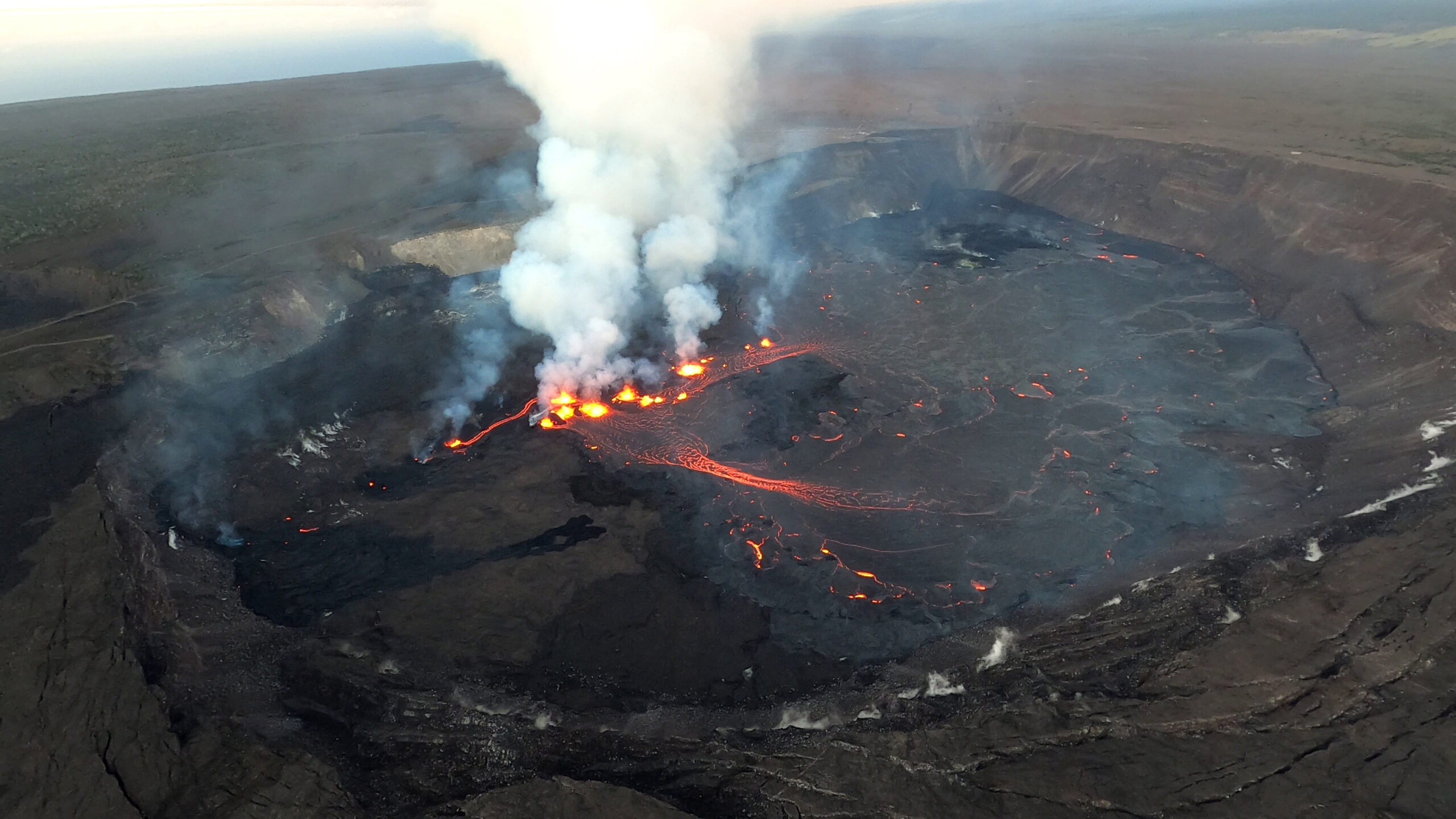
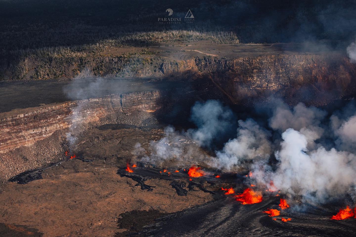
An aerial view of the eruption at the summit of Kīlauea at approximately 6:30 a.m. HST on September 11, 2023. Multiple minor fountains remain active in the eastern portion of Halema‘uma‘u crater floor and on the downdropped block within Kīlauea’s summit caldera.
Halemaʻumaʻu Lava Lake Observations:
Several lava fountains remain active on the western side of the downdropped block within Kīlauea’s summit caldera. The easternmost vents on the downdropped block and the westernmost vents in Halema‘uma‘u became inactive yesterday, and the remaining active vents on the downdropped block span approximately 0.5 miles (750 m). These vents are roughly east-west trending and are feeding channelized lava flows traveling in north and west directions onto Halema‘uma‘u crater floor. The eastern rim of Halema‘uma‘u crater has been buried by new lava flows, and pāhoehoe lava flows cover most of the crater floor except high ground formed during previous eruptive activity in the southwest portions of the crater. Effusion rates appear down from initial eruptive rates, but remain high. Lava fountain heights have decreased since the eruption onset, but remain up to about 10-15 meters (32-50 feet) high this morning. The laser rangefinder is aimed at a western portion of Halema‘uma‘u crater, not near the new eruptive activity, and recorded nearly 5 m (16 feet) of uplift to this locality since the eruption started. This demonstrates that a significant amount of lava has intruded beneath the pre-existing crust within Halema’uma’u.
Summit Observations:
Summit tilt has remained deflationary over the past 24 hours. Summit seismic activity is dominated by eruptive tremor (a signal associated with fluid movement) with very few volcano tectonic earthquakes. Volcanic gas emissions in the eruption area are elevated; a sulfur dioxide (SO2) emission rate of 49,000 tonnes per day was measured yesterday afternoon, September 11. This is down significantly from the 190,000 tonnes per day measured just after the onset of the eruption on Sunday, September 10th.
Source : HVO.
Photos : USGS / M. Patrick , Andrew Hara / Paradise helicopters.
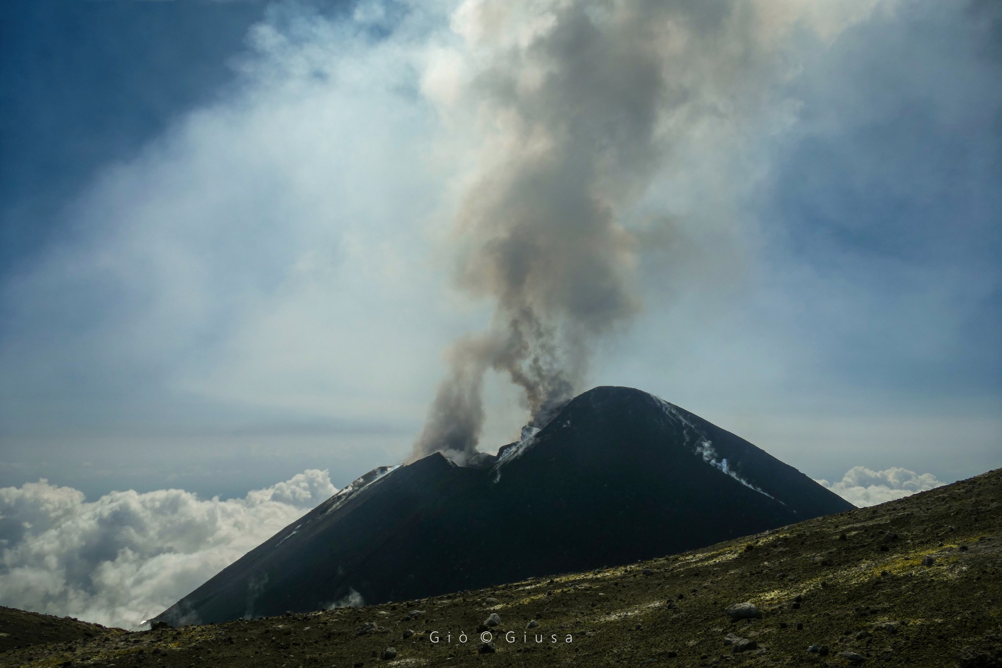
Italy / Sicily , Etna :
SUMMARY STATEMENT OF ACTIVITY
In light of the monitoring data, it appears:
1) VOLCANOLOGICAL OBSERVATIONS: Degassing activity at the summit craters, particularly at the Bocca Nuova crater (BN) and the South-East crater (CSE).
2) SISMOLOGY: Absence of seismic fracturing activity with Ml>=2.0. Stationarity of volcanic tremor parameters.
3) INFRASOUND: Underestimated event occurrence rate during the first five days of the week.
Moderate to high infrasound activity for the remainder of the week.
4) GROUND DEFORMATIONS: Over the past week, ground deformation monitoring networks have not recorded significant changes
5) GEOCHEMISTRY: SO2 flux at medium level
CO2 flux from growing soil on average values.
There is no update on the helium isotope ratio.
The partial pressure of dissolved CO2 does not show significant variations.
6) SATELLITE OBSERVATIONS: Thermal activity observed by satellite was generally weak.
VOLCANOLOGICAL OBSERVATIONS
The monitoring of the volcanic activity of Etna was carried out through the analysis of images from the INGV surveillance camera network, Osservatorio Etneo (INGV-OE). Observations of activity at the summit craters were impossible from September 6 to 8 due to the continued presence of thick cloud cover. In the following days, improved weather conditions made it possible to follow the activity, albeit intermittently.
During the few days of observation, the activity of the summit craters of Etna was characterized by degassing of varying intensity, as reported in the previous week’s bulletin (Rep. N. 36/2003 ETNA). In particular, the Bocca Nuova (BN) crater was characterized by intense degassing accompanied by nocturnal glow.
The Southeast crater showed characteristic continuous degassing from the two vents located in the eastern sector of the cone, and weaker degassing from the numerous fumaroles located along the crater rim.
Finally, the Northeast crater (CNE) and the Voragine crater (VOR) remained obstructed and showed weak fumarolic activity.
Source : INGV.
Photo : Gio Giusa.
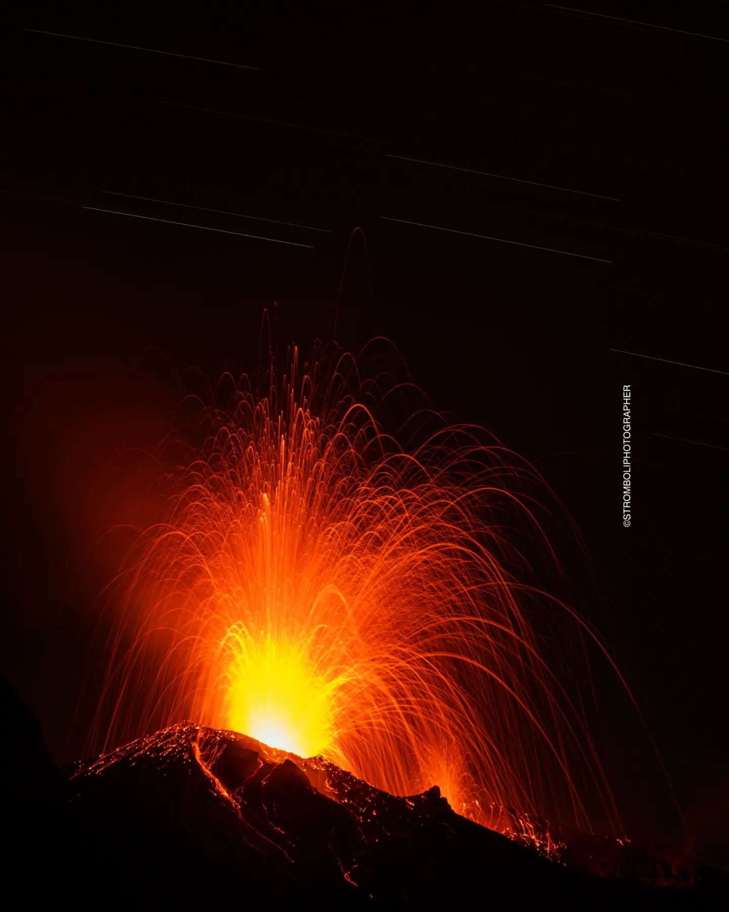
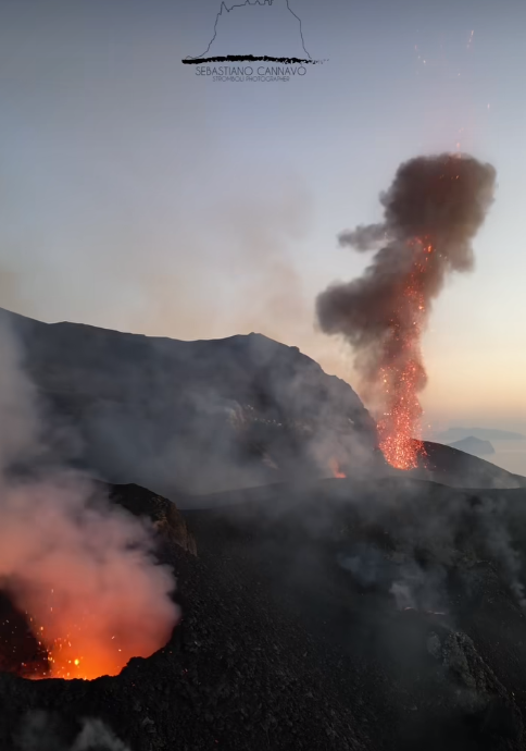
Italy , Stromboli :
SUMMARY STATEMENT OF ACTIVITY
In light of the monitoring data, it appears:
1) VOLCANOLOGICAL OBSERVATIONS: Ordinary explosive activity of the Strombolian type of medium level and with splashing activity in the North crater area, intensity of explosions varying from low to medium in the North and Central-South zone.
2) SISMOLOGY: The monitored seismological parameters do not show significant variations.
3) GROUND DEFORMATIONS: The island’s ground deformation monitoring networks showed no significant changes to report for the period under review.
4) GEOCHEMISTRY: SO2 flux at an average and increasing level
The CO2 flow in the Pizzo area shows stable values at average levels.
There is no update on the C/S ratio in the plume.
There is no update on the isotope ratio of dissolved helium in groundwater.
5) SATELLITE OBSERVATIONS: Thermal activity observed by satellite was generally weak with rare and isolated anomalies of moderate level.
VOLCANOLOGICAL OBSERVATIONS
In the observed period, the eruptive activity of Stromboli was characterized through the analysis of images recorded by the INGV-OE surveillance cameras at altitude 190m (SCT-SCV), from
Pizzo and Punta dei Corvi and thanks to an inspection carried out in the summit area by INGV staff on September 9. Overall, the explosive activity was mainly produced by 3 (three) eruptive chimneys located in the northern zone of the crater and by 2 (two) chimneys located in the South Central zone.
Observations of explosive activity captured by surveillance cameras
In the area of the North crater (N), with two vents located in sector N1 and one in sector N2, explosive activity of varying intensity from low to medium was observed, respectively less than 80 and 150 meters higher than the crater terrace. The products emitted in the eruption were mainly coarse materials (bombs and lapilli) sometimes mixed with fine materials (ashes). Furthermore, splashing activity was observed in sector N1 with an increase on September 4. The average frequency of explosions varied between 6 and 9 events/h. In the South-Central (CS) zone, sectors S1 and C did not show significant activity while sector S2, with two active vents, mainly showed explosive activity of varying intensity from low to medium emitting coarse material mixed with fine material. The average frequency of explosions fluctuated between 5 and 7 events/h. The average total frequency of explosive activity was placed at an average level oscillating between 11 and 14 events/h.
Field observations as of September 9, 2023
On September 9, an inspection was carried out in the summit area between 11:30 a.m. and 1:00 p.m. (local time), in order to check the morpho-structural structure of the crater area and observe the explosive activity produced by the crater areas. During the first hour of observations, explosive activity was sustained, with launches of coarse material produced from both crater areas.
Vent N1, located in the North Crater area, produced jets with an occasional distribution of spatter, the fallout of which occurred almost entirely on the Sciara del Fuoco. The S2 of the Central-South crater area produced jets approximately 200 m high from the third crater with fallout exclusively on the crater terrace and the Sciara side.
No type of fresh product has been identified on the Pizzo. Towards the end of the first hour of observation, the activity experienced a decrease in both frequency and intensity, with the emission of mainly ash-like material mixed with coarse material. Overall, the frequency of explosions was established at an average value of 12 to 14 events/h, with a medium-high intensity with jets of up to 200 m in both S2 and N1.
During the inspection, variations in the morpho-structural structure of the crater areas were observed compared to the observations during the previous month’s inspection, in detail:
– N1: a vent on the sciara side which produced projections and explosive activity of coarse matter
– N2: two vents, one of which produces detonations with little or no emission of material; the other in explosive activity emitting coarse materials. Between N1 and N2 there are the remains of a hornito which is no longer active.
– Central: three vents, i.e. 2 hornitos and a vent inside a squat cone which produced gas puff activity. At the base of the two hornitos, deposits attributable to small rheomorphic flows were visible, probably due to slight previous projection activity.
– S1: a degassing hornito
– S2: several vents, the most active of which is a hornito with a mouth large enough to allow high jets of mainly coarse material.
Source : INGV.
Photos : Stromboli stati d’animo / Sebastiano Cannavo.
Chile , Villarica :
Special Report on Volcanic Activity (REAV), La Araucanía and Los Ríos regions, Villarrica volcano, September 12, 2023, 7:17 p.m. local time (mainland Chile)
The National Geology and Mining Service of Chile (Sernageomin) announces the following PRELIMINARY information, obtained through the monitoring equipment of the National Volcanic Monitoring Network (RNVV), processed and analyzed at the Observatory of Volcanoes of the Southern Andes (Ovdas):
On Tuesday September 12, 2023, at 7:00 p.m. local time (Tuesday September 12, 2023 10:00 p.m. UTC), monitoring stations installed near the Villarrica volcano recorded an earthquake associated with fluid dynamics inside the volcanic system (LP type) .

The characteristics of the earthquake, after its analysis, are as follows:
ORIGINAL TIME: 7:00 p.m. local time (10:00 p.m. UTC)
REDUCED TRAVEL: 268.52 (cm*cm)
ACOUSTIC SIGNAL: 1.3 Pascals (Pa) reduced to 1 km
COMMENTS:
The crater of the volcano could not be observed due to cloudiness in the area, no changes were recorded in the seismic behavior of the volcano following the reported event.
The volcanic technical alert is maintained at the Yellow level.
Source : Sernageomin.
Photo : volcanologia en Chile .
Colombia , Chiles / Cerro Negro :
Weekly activity bulletin of the Chiles and Cerro Negro Volcanic Complex (CVCCN)
Regarding the monitoring of the activity of the CHILES AND CERRO NEGRO VOLCANOES, the MINISTRY OF MINES AND ENERGY, through the COLOMBIAN GEOLOGICAL SERVICE (SGC), reports that:
During the week between September 5 and 11, 2023, a decrease in the number of earthquakes was observed, while the energy released remained similar to that recorded the previous week.
The predominance of seismicity linked to the fracture of rock materials within the volcanic complex was maintained.
Most of the earthquakes were located towards the south of the Chiles volcano, with distances up to 3.5 km, depths less than 5 km compared to the height of its summit (4,700 m above sea level). of the sea) and a maximum magnitude of 2.9. No earthquakes were reported as felt.
The recording of the deformation processes of the volcanic edifice continued, which are detected instrumentally by sensors installed on the volcanoes and by satellite sensors.
The seismicity occurring in the zone of influence of the Chiles – Cerro Negro volcanic complex is part of a fluctuating process that began at the end of 2013 and continues its course until now. The largest recent increase began on March 9, 2023, with the recording of more than 226,000 earthquakes in the last 6 months, most associated with the fracturing of rocks within the volcanic system, some of them being reported as felt by residents residing near the epicentral zone.
The recorded seismicity shows variations in its occurrence and mainly in its energy levels, due to the complex interaction between the CVCCN magmatic system, the hydrothermal system and the geological faults of the region. The occurrence of earthquakes of greater magnitude is likely to generate instability on slopes, landslides and structural damage to buildings, access roads, bridges, etc., aspects which must continue to be taken into account by authorities and communities residing in the zone of influence of these volcanoes.
The probability of the occurrence of energetic earthquakes that could be felt by residents in the CVCCN zone of influence remains.
The level of activity of the volcanoes remains at the level:
YELLOW LEVEL ■ (III): CHANGES IN THE BEHAVIOR OF VOLCANIC ACTIVITY
Source : SGC
Photo : Travelgrafía