April 24 , 2018.
Ambae , Vanuatu :
VANUATU VOLCANO ALERT BULLETIN N°4 – AMBAE ACTIVITY
Monday April 23rd 2018
15°24’0”S 167°50’0”E
Summit 4908ft (1496m)
Current Vanuatu Volcano Alert Level: Level 3
Ambae volcano is continuing in the minor eruption state; Its Volcanic Alert Level remains at Level 3 .
The volcanic eruption at Lake Voui continues. The volcanic activity is likely to continue at similar levels, consistent with Volcanic Alert Level 3. Activity may also show changes with periods of stronger or weaker activity from time to time. The Danger Zone for life safety is limited at 3 km radius from the active vent and areas located in the Yellow Zone .
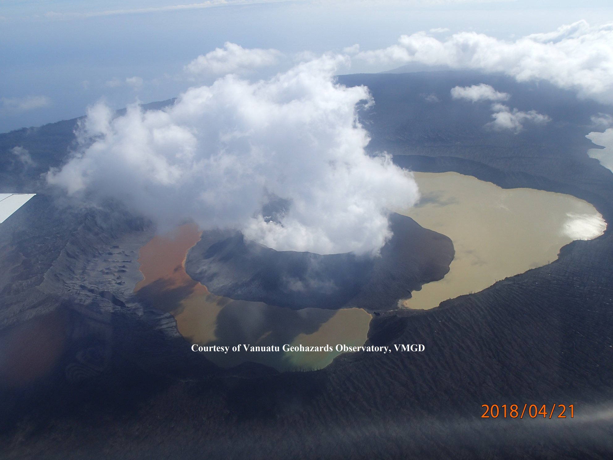
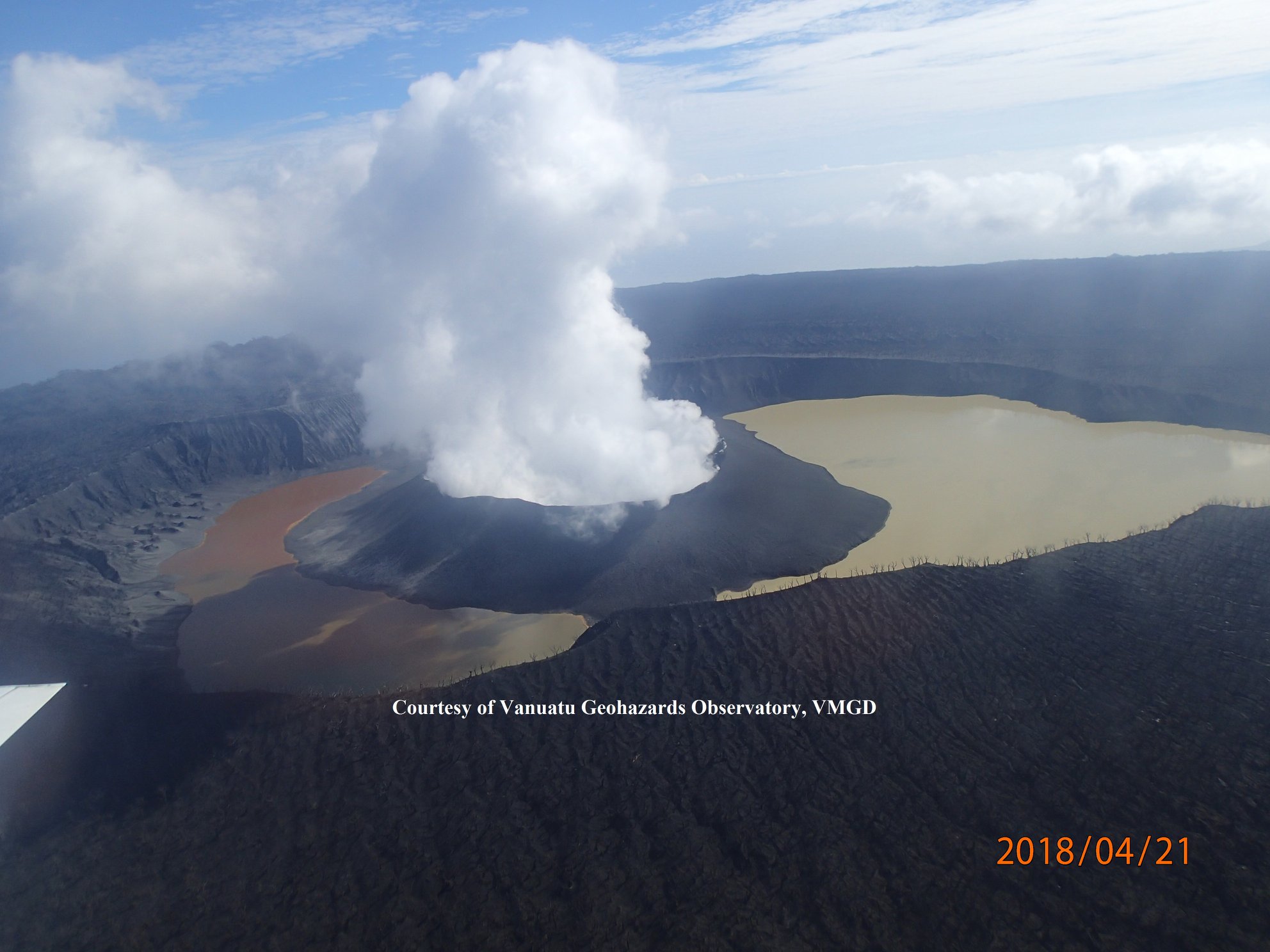
Observations on 21st April 2018 confirm that the eruptions in April have changed the volcanic cone in Lake Voui. The cone is now larger and a large crater has formed. A small Lake is present in the active crater. During April, the eruptions were typically volcanic ash forming and some lava fountain. This created ash fall and scoria fall on Ambae. The eruptions are also producing volcanic gas and acid rain. Gas will continue to be smelt.
The presence of ash that has fallen on Ambae has changed the behavior of streams and creeks when it rains. The creeks and streams can produce floods and carry a lot more debris (sands, gravel and boulders). The flow path of streams and creeks could change due to the flood debris. Landslide may occur at some areas during heavy rain fall.
These observations and the analysis of seismic data confirm that the minor level of volcano activity is continuing. The volcano activity consist of ongoing emission of steam and gases, with volcanic ash during explosions.
The current activity can include ashes and gases emission causing some impact to villages. This is consistent with the Alert Level 3 activity. Level 3 indicates ‘Minor eruption; Danger is at 3 km around the volcanic vent and areas that exposed to the wind direction’ . The possibility that the Ambae volcano activity escalate to the level of moderate eruption is low .
Source : Geohazard
Piton de la Fournaise , La Réunion :
Volcanological observatory of Piton de la Fournaise
Activity Bulletin from Monday, April 23, 2018 to 12:00 (local time).
Since April 21st, the seismic activity above the Piton de la Fournaise summit has resumed with 24 earthquakes registered on April 22nd. These superficial volcano-tectonic earthquakes (<2 km deep) were recorded below the summit zone.

Figure 1: Histogram showing the number of superficial volcano-tectonic earthquakes recorded under the summit craters between April 4 (end of the last eruption) and April 22, 2018. (© OVPF / IPGP)
This resumption of seismicity and the acceleration observed yesterday are the result of:
– the continued inflation (swelling) of the building observed following the end of the eruption of April 3-4 (up to 2.5 cm of elongation at the summit in 15 days), synonymous with a deep refeeding magma and pressurization of the superficial magmatic reservoir (Figure 2);

Figure 2: Illustration of the deformation during the last twelve months (the injection of magma of May 17, 2017 is represented by a black bar and the eruptions of July 14-August 28, 2017 and April 3-4, 2018 are represented in yellow) . Here is shown a baseline (distance between two GPS receivers) crossing the Dolomieu crater from north to south (in black the raw data, in blue the data smoothed over a week). A rise is synonymous with elongation and therefore swelling of the volcano; conversely, a decrease is synonymous with contraction and therefore deflation of the volcano. (© OVPF / IPGP)
– a large increase in the CO2 concentration in the soil observed in the far field following the end of the eruption of April 3-4, followed, from April 19, by a very strong drop in concentrations (Figure 3). This geochemical evolution also highlights a continuation of the deep recharge and a possible transfer to lower depths (shallow reservoir) since mid-April (lower CO2 ground).

Figure 3: Average CO2 concentration in the soil at the Volcanological Observatory (Bourg Murat) between February 1 and April 23, 2018 (the eruption of April 3-4, 2018 is shown in red). Values are normalized to the maximum value recorded. (© OVPF / IPGP)
Conclusion: The acceleration of the seismicity observed yesterday shows that the pressurization of the reservoir is accelerating and that the latter is weakened.
Source : OVPF
Sabancaya , Peru :
Explosive activity increased slightly, averaging 19 explosions / day. The predominance of events associated with fluid movements (long period type) continues. The events associated with ash emissions (Tremor type) have increased mainly over the last 2 days, reaching up to 11 hours of Tremor. The earthquakes that indicate the rise of the magma (hybrid type) remain low in number and energy.
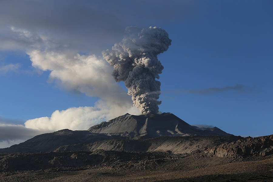
Eruptive columns of gas and ash reached a maximum height of about 2200 m above the crater. The dispersal occurred within a radius of about 40 km, mainly in the northwest, west, southwest direction.
Between 16 and 19 April, the volcanic gas flow (SO2) recorded on April 17 a maximum value of 3421 tons / day, a value considered large.
The method of measuring the deformation did not show any significant changes compared to the previous week.
Five thermal anomalies were recorded according to the MIROVA system, with values between 2 MW and 48 MW VRP (Radiated Volcano Power).
In general, eruptive activity maintains moderate levels. A slight increase in volcanic activity over the next few days is not excluded.
Source : IGP
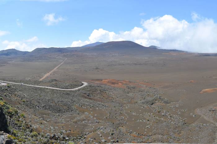
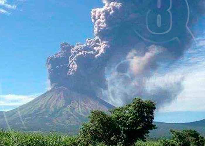
San Cristobal , Nicaragua :
A degassing process of the San Cristóbal volcano, followed by a minimal emanation of ash around its flanks, was recorded at 1:30 am Sunday afternoon.
The population of Chinandega has not felt any tremor and has followed its Sunday rest routine to perform the prayers called by the Catholic and Evangelical churches, given the crisis that Nicaragua is experiencing through the reforms of the INSS.
« It is a typical activity of a volcano that remains active, the micro – seismas are imperceptible and obey the intense heat, » said Álvaro Romero, member of Chinandega Comupred.
The official explained that no meeting was organized for such an activity and that the staff was not mobilized.
The San Cristobal volcano, the highest peak in Nicaragua, does not emit smoke and its summit is hidden among the gray clouds.
Source : El Nuevo Diario
Photo : TN8
Kilauea , Hawai :
19°25’16 » N 155°17’13 » W,
Summit Elevation 4091 ft (1247 m)
Current Volcano Alert Level: WATCH
Current Aviation Color Code: ORANGE
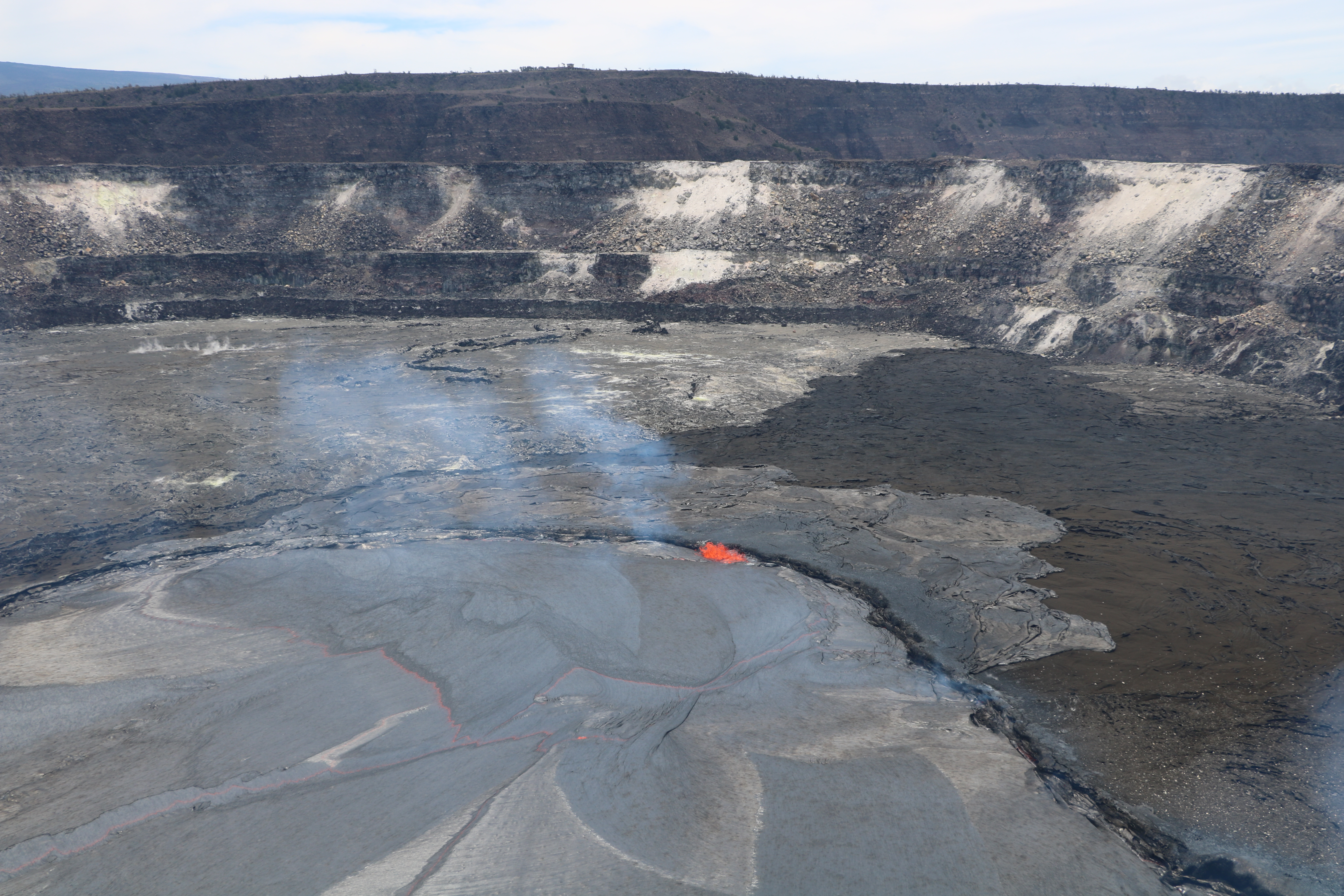
A wider view of the lava lake and recent overflows. This photo is taken from the Halema‘uma‘u Crater rim, and looks northwest. Jaggar Museum and HVO can be seen on the skyline.
Activity Summary:
Eruptions continue at Kīlauea Volcano’s summit and East Rift Zone. The summit lava lake overflowed the Overlook crater rim several times in the past day as summit tiltmeters continued to record an overall inflationary tilt. Puʻu ʻŌʻō cone continues the inflationary trend of the past several weeks, and the Episode 61g lava flow is active above Pulama pali. The flow does not pose a threat to nearby communities at this time. There is currently no active lava on the pali, the coastal plain, or entering the ocean.
Beginning around midnight on Saturday, April 21, Kīlauea Volcano’s summit lava lake rose high enough that lava briefly spilled onto the floor of Halema‘uma‘u. Since then, additional overflows occurred in four pulses on April 22–23. The largest one occurred during the fourth pulse, which started at 6:30 a.m. today (Monday, April 23) and continued for about three hours, covering about a third of the crater floor with shiny black lava.

Early this morning, HVO geologists used a laser range-finder to measure the depth to the lava lake surface at its peak level. The area around Halema‘uma‘u remains closed to the public due to ongoing volcanic hazards, including high sulfur dioxide gas emissions and unexpected rockfalls and explosions.
Source : HVO