June 02, 2021. EN. Italy / Sicily : Etna , United States : Yellowstone , Saint Vincent : Soufrière Saint Vincent , Italy : Stromboli , Indonesia : Semeru .

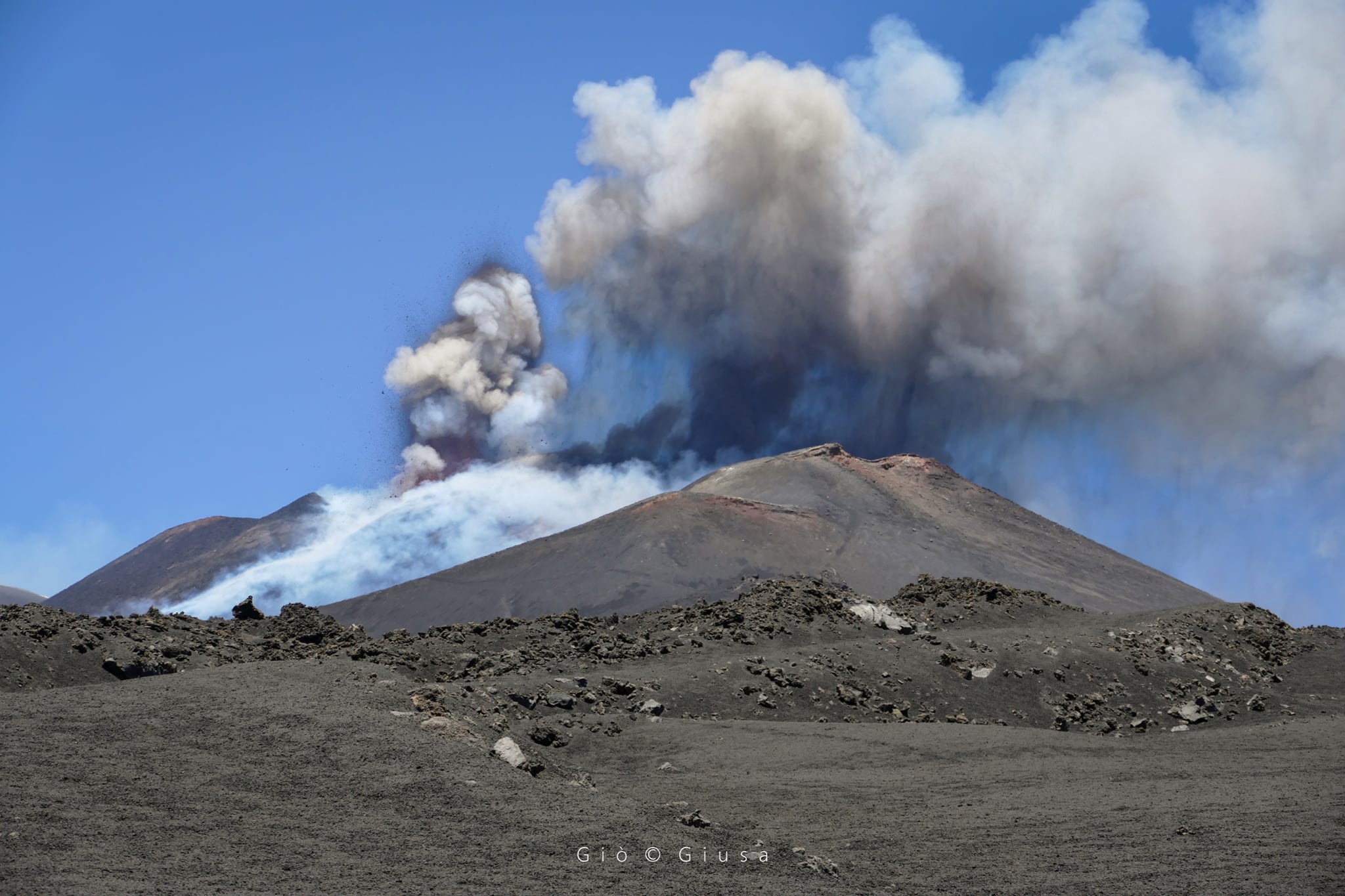
June 02 , 2021.


Italy / Sicily , Etna :

Weekly bulletin from May 24, 2021 to May 30, 2021, (issue date June 01, 2021)

SUMMARY OF THE STATE OF ACTIVITY
In the light of surveillance data, it is highlighted:
1) VOLCANOLOGICAL OBSERVATIONS: Eruptive episodes at the Southeast Crater; degassing activity of other summit craters.
2) SEISMOLOGY: Weak seismic activity of fracturing; the amplitude of the tremor varied from medium-low levels to high levels recorded during paroxysmal events
3) INFRASOUND: High infrasound activity concomitantly with lava fountain episodes at the Southeast Crater, low in the remaining period.
4) DEFORMATIONS: The GNSS network showed a weak tendency for deflation during the week. The inclinometric network showed simultaneous variations with the lava fountain events.

Map of the summit craters of Etna. BN: Bocca Nuova, VOR: Voragine; NEC: northeast crater; SEC: south-eastern crater. The topographic reference frame on which the morphological updates have been superimposed concerns the 2014 DEM developed by the Aerogeophysical Laboratory-Section Rome 2; map of the flow from 05/24/2021.

5) GEOCHEMISTRY: SO2 flux at an average level, with intra-daily values at a high level
The CO2 flux from the soil shows average values.
The partial pressure of dissolved CO2 in groundwater reaches background values.
No new data from the C / S ratio is available.
The helium isotope ratio shows a downward trend, remaining on average values (sampling of 05/14/2021).
6) SATELLITE OBSERVATIONS: The thermal activity in the summit area is high to very high level.


VOLCANOLOGICAL OBSERVATIONS
During the week, the monitoring of the volcanic activity of Etna was carried out by analyzing the images of the surveillance cameras of the INGV, Osservatorio Etneo (INGV-OE) and thanks to various inspections carried out by the staff of the INGV-OE, one of them (May 26) in the summit area.
During the week, there were several eruptive episodes at the Southeast Crater (SEC), which occurred on May 24, 25, 26, 27, 28 and 30, respectively. Most of these events consisted of the resumption of Strombolian activity at the Southeast Crater (SEC) followed by a gradual intensification of the eruptive phenomenon until, in some cases, the stage of a sustained lava fountain. This activity was also accompanied by lava overflows heading southwest, always remaining in the summit area. Due to adverse weather conditions, there is insufficient data to perform a correct flow mapping. Finally, degassing activity was observed at the level of the other summit craters.

The first eruptive episode of the week from the Southeast Crater (SEC) occurred on May 24 from 19:00 UTC. The most intense phase was reached between 20:35 UTC and 21:45 UTC.
The activity ended around 10:10 a.m. UTC. On the morning of May 25, around 08:20 UTC, ash was observed near the Southeast Crater (SEC). This activity formed a light eruptive cloud about 4000 m high, dispersed towards the East-North-East. Explosive activity resumed in the afternoon at around 4:20 p.m. UTC and it was only after half an hour that an increase in Strombolian activity at the Southeast Crater (SEC) was recorded. The most intense phase took place between 18:25 and 19:00 UTC. The activity ended around 8:15 p.m. UTC.

Two more eruptive episodes occurred on May 26 and reached the phase of greatest intensity at around 1:50 a.m. and 11:00 a.m. UTC, respectively. On May 27, the Southeast Crater (SEC) was the
protagonist of a new eruptive episode, which intensified around 12:50 UTC. Due to bad weather conditions, it was not possible to observe the eruptive phenomenon from the INGV-OE surveillance cameras. During this event, a fall of pyroclastic material was reported in Giarre, Milo and Fornazzo. Three other eruptive episodes occurred on May 28, in the morning, late afternoon and evening. During the morning, the activity, which started around 06:30 UTC, peaked at around 07:00 UTC and then ended at 07:30 UTC. For this event, a fall of volcanic ash in Giarre was reported by INGV-OE personnel in the field. This activity anticipated two other very close episodes, the first, very mild and short, started at 3:40 p.m. UTC and was already finished by 4:15 p.m., the second, more powerful, started around 7:15 p.m. UTC and finished at 9:05 p.m. UTC. Finally, the last episode of the week of May 30, which started around 3:45 a.m. UTC, lasted about two hours.

The information on the height of the eruptive cloud was obtained from the analysis of data, when available, satellite images and the ECV calibrated camera.
The maximum height measured during all of these events is 7000 m above sea level. In general, the deposits consist mainly of fine material. Taking into account all the eruptive episodes, the sector of the volcano most affected by the fallout of ash and lapilli was that of the east. Finally, most of these episodes produced lava overflows that spread southwest along the sides of the Southeast Crater. During the same inspection, the INGV-OE confirmed the absence of eruptive activity at Voragine, Bocca Nuova and at the Northeast Crater.

Source : INGV

Read the article: https://www.ct.ingv.it/index.php/monitoraggio-e-sorveglianza/prodotti-del-monitoraggio/bollettini-settimanali-multidisciplinari/506-bollettino-settimanale-sul-monitoraggio-vulcanico-geochimico-e-sismico-del-vulcano-etna20210601/file

Photos : Guide Alpine Vulcanologiche Etna ( 26 /05) , Gio Giusa ( 26 /05) .


United States , Yellowstone :

44°25’48 » N 110°40’12 » W,
Summit Elevation 9203 ft (2805 m)
Current Volcano Alert Level: NORMAL
Current Aviation Color Code: GREEN

Recent work and news
In the past month there were two major water eruptions of Steamboat Geyser, on May 5 and 31. This brings the total number of eruptions for the year to 12.

During the month of May, Yellowstone Volcano Observatory scientists installed 15 semi-permanent GPS stations in and around Yellowstone National Park. These stations are deployed every spring and recovered in the fall, operating during the period of largely snow-free conditions, and they serve to augment the network of continuous GPS stations, which operate year-round. Scientists also performed maintenance on the temperature monitoring network at Norris Geyser Basin, replacing batteries and damaged equipment as needed. June will see additional work, including the deployment of nodal seismic stations in the Norris Geyser Basin, especially in the area of Steamboat Geyser and Cistern Spring. The goal of the seismic experiment is to better image the hydrothermal plumbing system that feeds individual thermal features at Norris Geyser Basin.

View of Castle Geyser, near Old Faithful, in eruption, taken from the boardwalk, November 5, 2019.

Seismicity
During May 2021, the University of Utah Seismograph Stations, responsible for the operation and analysis of the Yellowstone Seismic Network, located 72 earthquakes in the Yellowstone National Park region. The largest event was a microearthquake of magnitude 2.5 located 7 miles south of West Thumb, Yellowstone National Park, on May 23 at 5:53 AM MDT.

No swarm activity was observed in April.

Yellowstone earthquake activity remains at background levels.

Ground deformation
Deformation rates and styles at Yellowstone, as recorded by continuous GPS stations, have been steady over the past year. Subsidence of Yellowstone Caldera, which has been ongoing since 2015, continued at an average rate of 2–3 cm (about 1 in) per year. In the area of Norris Geyser Basin, no significant uplift or subsidence has been detected by a nearby GPS station since the start of 2020.

Source : YVO.

Photo : Shaul Hurwitz /USGS .


Saint Vincent , Soufrière Saint Vincent :

La Soufriere Volcano – SCIENTIFIC UPDATE 31/05/21 6:00PM

– Seismic activity at La Soufrière, St Vincent has remained low since the tremor associated with the explosion and ash venting on 22 April.
– From 5:40am on 30 May to 8:00am (local time) on 31 May, there has been no recorded seismicity associated with La Soufrière.
– Persistent steaming is observable from the observatory once the cloud cover is high enough.
– Thermal anomalies continue to be detected by the NASA FIRMS alert system.

This image taken on 29May shows the new look of La Soufriere, Saint Vincent from the Leeward (western) side. Professor Robertson has labelled the photo so we can notice the 1812 crater with tis lake, the 1979 crater rim, the 2021 explosion crater and the lowest point along the rim: the Larakai Gap. One can note that a lake is still present in the same location prior to this eruption. The alert is still at Orange and access to the volcano is still prohibited at this time.

– Thermal anomalies do not indicate an explosive event is imminent but that there is a source of heat, most likely from a small body of magma left over, close to the floor of the Summit Crater.
– The volcano continues to be in a state of unrest. Escalation in activity can still take place with little or no warning.

– The volcano is at alert level ORANGE

Source : UWI.

Photo : Francesco Gomez & Sandra Montabard, Martinique.


Italy , Stromboli :

Weekly bulletin from May 24, 2021 to May 30, 2021, (issue date June 01, 2021)

SUMMARY OF THE STATE OF ACTIVITY

In the light of surveillance data, it is highlighted:
1) VOLCANOLOGICAL OBSERVATIONS: Ordinary explosive volcanic activity of Strombolian type accompanied by splashing activity sometimes intense in zone N2. The total frequency of events showed values ​​ranging from medium-low to medium (8-14 events / h). The intensity of the explosions varied from low to medium in the North crater area and medium-high in the Center-South area.
2) SEISMOLOGY: The seismological parameters monitored do not show significant changes, except for the increase in the amplitude of the tremor on May 24-25.
3) DEFORMATIONS: A weak transient deformation is noted in the inclinometric signal of Timpone del Fuoco in the morning of Saturday, May 29, 2021.
4) GEOCHEMISTRY: SO2 flux at an average level
The C / S ratio in the plume is at average values.
The isotopic ratio of He dissolved in the thermal aquifer remains at an average level.
5) SATELLITE OBSERVATIONS: The thermal activity in the summit area is moderate to low.


VOLCANOLOGICAL OBSERVATIONS
In the observation period, the eruptive activity of Stromboli was characterized by analyzing the images recorded by the surveillance cameras INGV-OE located at an altitude of 190 m, in Punta Corvi and at an altitude of 400 m.

Ground observations made on May 26 by INGV staff confirmed the absence of power to the flow observed by satellite already on May 24. In addition, observations indicated the presence at crater N2 of at least 6 active vents characterized by splashing, at least 4 of which are aligned and simultaneously produce eruptive activity. In addition, it was observed that the slag cone which occupied the central zone of the Center-North zone until May 16 is partially destroyed and without explosive activity. Behind him was formed a great depression. Finally, during the inspection of Pizzo on May 26, no product associated with the collapse of May 19 was found.
The splash activity at the mouth of the N2 crater was almost completely absent or very modest on May 27, when ash emissions and gas jets resumed in both the North area and the Center-South area. from the crater.

N2 crater area, white arrows indicate active vents, blue line the collapse limit, SdF = Sciara del Fuoco.

As part of the activities of the UNO / INGV-DPC Project, a DSM of the North area of ​​the crater terrace was developed through the analysis of data collected on May 27, in order to estimate by subtraction with the DSM of 7 May, the volume of material involved in the event on May 19. The results of the analyzes indicated that the collapse involved both the area of ​​the northern crater and the upper part of the nearby Sciara del Fuoco. The thickness of the lost material varies between 22 and 2 m while the material accumulated under the crater terrace has on the contrary a variable thickness between 2 and 12 m. There is a significant increase of 12 meters in the southern sector of the N2 crater from May 7 which highlights an increase in Strombolian activity in the period preceding the landslide.
Overall, the volume of material involved in the collapse, expressed as lost volume, amounts to 79,000 ± 7,000 m3. However, part of the collapsed area has already been filled in by flow and splash activity and, as mentioned above, crater N2 was likely larger than the May 7 relief. It follows that the missing volume must necessarily be greater. The volume accumulated in the investigated sector is equal to 13,600 ± 4,500 m3. The threshold value for detectable height differences is ± 0.5 m.

Shaded diagram of the crater area of ​​May 7 and 27, 2021, respectively (A and B); in (C) difference expressed in m between the DSM of 27 and 07 May 2021, the color scale from red to blue indicates the thicknesses in m of the accumulated material and the lost material respectively. The lines of different colors delimit the areas of the crater, in (B) the red circles indicate the active mouths and SdF = Sciara del Fuoco.

In the area of ​​the North crater, the N1 crater, with two emission points, produced explosions of varying intensity from low to medium (sometimes the products reached 150 m in height) emitting coarse materials (lapilli and bombs) . The N2 mouthpiece, with four emission points, showed explosive activity of varying intensity from low to medium-high (sometimes the products reached 250 m in height) emitting mainly coarse material with splash activity that was intense for short intervals. The average frequency of explosions varied from 6 to 13 events / h.
In the Center-South zone at least two emission points were detected with explosions emitting mainly fine materials with medium and sometimes high intensity (the products exceeded 250 m in height). The explosive activity showed average hourly frequency values ​​between less than 1 and 4 events / h.

Source : INGV.

Read the article https://www.ct.ingv.it/index.php/monitoraggio-e-sorveglianza/prodotti-del-monitoraggio/bollettini-settimanali-multidisciplinari/507-bollettino-settimanale-sul-monitoraggio-vulcanico-geochimico-e-sismico-del-vulcano-Stromboli20210601/file

Photos : INGV.


Indonesia , Semeru :

VOLCANO OBSERVATORY NOTICE FOR AVIATION – VONA.

Issued : June 01 , 2021
Volcano : Semeru (263300)
Current Aviation Colour Code : ORANGE
Previous Aviation Colour Code : orange
Source : Semeru Volcano Observatory
Notice Number : 2021SMR31
Volcano Location : S 08 deg 06 min 29 sec E 112 deg 55 min 12 sec
Area : East java, Indonesia
Summit Elevation : 11763 FT (3676 M)


Volcanic Activity Summary :
Eruption with volcanic ash cloud at 23h16 UTC (06h16 local). Eruption and ash emission is continuing

Volcanic Cloud Height :
Best estimate of ash-cloud top is around 13683 FT (4276 M) above sea level, may be higher than what can be observed clearly. Source of height data: ground observer.

Other Volcanic Cloud Information :
Ash-cloud moving to southeast

Source : Magma Indonésie .

Photo : Umarul Faruq

02 Juin 2021. FR. Italie / Sicile : Etna , Etats-Unis : Yellowstone , Saint Vincent : Soufrière Saint Vincent , Italie : Stromboli , Indonésie : Semeru .

02 Juin 2021.


Italie / Sicile , Etna :

Bulletin hebdomadaire du 24 Mai 2021 au 30 Mai 2021, (date d’émission 01 Juin 2021)

SOMMAIRE DE L’ÉTAT D’ACTIVITÉ
À la lumière des données de surveillance, il est mis en évidence:
1) OBSERVATIONS VOLCANOLOGIQUES: Épisodes éruptifs au Cratère Sud-Est; activité de dégazage des autres cratères sommitaux.
2) SISMOLOGIE: Faible activité sismique de fracturation; l’amplitude du tremor variait de niveaux moyens-faibles à des niveaux élevés enregistrés pendant les événements paroxystiques
3) INFRASONS : Activité infrasonore élevée concomitamment aux épisodes de fontaine de lave au Cratère Sud-Est, faible dans la période restante.
4) DÉFORMATIONS: Le réseau GNSS a montré une faible tendance à la déflation au cours de la semaine. Le réseau inclinométrique a montré des variations simultanées aux événements de fontaine de lave.

Carte des cratères sommitaux de l’Etna. BN : Bocca Nuova, VOR : Voragine ; NEC : cratère nord-est ; SEC : cratère sud-est. Le référentiel topographique sur lequel ont été superposées les mises à jour morphologiques concerne le DEM 2014 élaboré par le Laboratoire d’Aérogéophysique-Section Rome 2 ;  carte de la coulée du 24/05/2021.

5) GÉOCHIMIE: flux de SO2 à un niveau moyen, avec des valeurs infra-quotidiennes à un niveau élevé
Le flux de CO2 du sol montre des valeurs moyennes.
La pression partielle de CO2 dissous dans les eaux souterraines atteint les valeurs de fond.
Aucune nouvelle donnée du rapport C / S n’est disponible.
Le rapport isotopique de l’hélium montre une tendance à la baisse, restant sur des valeurs moyennes (échantillonnage du 14/05/2021).
6) OBSERVATIONS SATELLITES: L’activité thermale dans la zone du sommet est de haut à très haut niveau.


OBSERVATIONS VOLCANOLOGIQUES
Au cours de la semaine, le suivi de l’activité volcanique de l’Etna a été réalisé en analysant les images des caméras de surveillance de l’INGV, Osservatorio Etneo (INGV-OE) et grâce à diverses inspections effectuées par le personnel de l’INGV-OE, l’une d’entre elles (le 26 mai) dans la zone du sommet .
Au cours de la semaine, il y a eu plusieurs épisodes éruptifs au Cratère Sud-Est (SEC), qui se sont produits respectivement les 24, 25, 26, 27, 28 et 30 mai. La plupart de ces événements consistaient en la reprise de l’activité strombolienne au Cratère Sud-Est (SEC) suivie d’une intensification progressive du phénomène éruptif jusqu’au, dans certains cas, stade de fontaine de lave soutenue. Cette activité était également accompagnée de débordements de lave qui se dirigeaient vers le Sud-Ouest, restant toujours dans la zone du sommet. En raison de conditions météorologiques défavorables, les données sont insuffisantes pour effectuer une cartographie correcte des flux.  Enfin, une activité de dégazage a été observée au niveau des autres cratères sommitaux.

Le premier épisode éruptif de la semaine du Cratère Sud-Est (SEC) s’est produit le 24 mai à partir de 19h00 UTC. La phase la plus intense a été atteinte entre 20h35 UTC et 21h45 UTC .
L’activité s’est terminée vers 10 h 10 UTC. Le matin du 25 mai, vers 08h20 UTC, des cendres ont été observées auprès du Cratère Sud-Est (SEC). Cette activité a formé un léger nuage éruptif d’environ 4000 m de haut, dispersé vers l’Est-Nord-Est. L’activité explosive a repris dans l’après-midi vers 16h20 UTC et ce n’est qu’après une demi-heure qu’une augmentation de l’activité strombolienne au Cratère Sud-Est (SEC) a été enregistrée. La phase la plus intense s’est déroulée entre 18h25 et 19h00 UTC . L’activité s’est terminée vers 20h15 UTC.

Deux autres épisodes éruptifs se sont produits le 26 mai et ont atteint la phase de plus grande intensité vers 01h50 et 11h00 UTC, respectivement . Le 27 mai, le Cratère Sud-Est (SEC) était le 
protagoniste d’un nouvel épisode éruptif, qui s’est intensifié vers 12h50 UTC . En raison de mauvaises conditions météorologiques, il n’a pas été possible d’observer le phénomène éruptif depuis les caméras de surveillance INGV-OE. Au cours de cet événement, une chute de matière pyroclastique a été signalée à Giarre, Milo et Fornazzo. Trois autres épisodes éruptifs se sont produits le 28 mai, en matinée, en fin d’après-midi et en soirée. Au cours de la matinée, l’activité, qui a débuté vers 06h30 UTC, a atteint son intensité maximale vers 07h00 UTC puis s’est terminée à 07h30 UTC  . Pour cet événement, une chute de cendres volcaniques à Giarre a été signalée par le personnel d’INGV-OE sur le terrain. Cette activité a anticipé deux autres épisodes très proches, le premier, très doux et court, a commencé à 15h40 UTC et était déjà terminé à 16h15 , le second, plus puissant, a commencé vers 19h15 UTC et terminé à 21h05 UTC . Enfin, le dernier épisode de la semaine du 30 mai, qui a débuté vers 03h45 UTC, a duré environ deux heures  .

Les informations sur la hauteur du nuage éruptif ont été obtenues à partir de l’analyse des données, lorsqu’elles étaient disponibles, des images satellites et de la caméra calibrée ECV. 
La hauteur maximale mesurée lors de tous ces événements est de 7000 m au-dessus du niveau de la mer. En général, les dépôts se composent principalement de matériaux fins.  Compte tenu de tous les épisodes éruptifs, le secteur du volcan le plus touché par les retombées de cendres et de lapilli était celui de l’Est. Enfin, la plupart de ces épisodes ont produit des débordements de lave qui se sont répandus vers le Sud-Ouest le long des flancs du Cratère Sud-Est. Au cours de la même inspection , l’INGV-OE a confirmé l’absence d’activité éruptive à la Voragine, la Bocca Nuova et au Cratère Nord-Est

Source : INGV

Lire l’article https://www.ct.ingv.it/index.php/monitoraggio-e-sorveglianza/prodotti-del-monitoraggio/bollettini-settimanali-multidisciplinari/506-bollettino-settimanale-sul-monitoraggio-vulcanico-geochimico-e-sismico-del-vulcano-etna20210601/file

Photos : Guide Alpine Vulcanologiche Etna ( 26 /05) , Gio Giusa ( 26 /05) .


Etats-Unis , Yellowstone :

44°25’48 » N 110°40’12 » O,
Élévation du sommet : 9203 pi (2805 m)
Niveau d’alerte volcan actuel : NORMAL
Code couleur de l’aviation actuel : VERT

Travaux récents et actualités
Au cours du mois dernier, il y a eu deux éruptions d’eau majeures du Steamboat Geyser, les 5 et 31 mai. Cela porte le nombre total d’éruptions pour l’année à 12.

Au cours du mois de mai, les scientifiques de l’observatoire du volcan Yellowstone ont installé 15 stations GPS semi-permanentes dans et autour du parc national de Yellowstone. Ces stations sont déployées chaque printemps et récupérées à l’automne, fonctionnant pendant la période de conditions largement sans neige, et elles servent à augmenter le réseau de stations GPS continues, qui fonctionnent toute l’année. Les scientifiques ont également effectué la maintenance du réseau de surveillance de la température à Norris Geyser Basin, remplaçant les batteries et les équipements endommagés au besoin. Juin verra des travaux supplémentaires, y compris le déploiement de stations sismiques nodales dans le Norris Geyser Basin, en particulier dans la région de Steamboat Geyser et Cistern Spring. L’objectif de l’expérience sismique est de mieux imager le système de plomberie hydrothermale qui alimente les caractéristiques thermiques individuelles du Norris Geyser Basin.

Vue du Castle Geyser, près d’Old Faithful, en éruption, prise depuis la promenade, le 5 novembre 2019.

Sismicité
En mai 2021, les stations sismographiques de l’Université de l’Utah, responsables de l’exploitation et de l’analyse du réseau sismique de Yellowstone, ont localisé 72 tremblements de terre dans la région du parc national de Yellowstone. Le plus grand événement a été un microséisme de magnitude 2,5 situé à 7 miles au Sud de West Thumb, dans le parc national de Yellowstone, le 23 mai à 5h53 MDT.

Aucune activité d’essaim n’a été observée en avril.

L’activité sismique de Yellowstone reste à des niveaux de fond.

Déformation du sol
Les taux et les styles de déformation à Yellowstone, tels qu’enregistrés par les stations GPS en continu, sont restés stables au cours de la dernière année. L’affaissement de Yellowstone Caldera, qui dure depuis 2015, s’est poursuivi à un rythme moyen de 2 à 3 cm (environ 1 pouce) par an. Dans la région du Norris Geyser Basin, aucun soulèvement ou affaissement significatif n’a été détecté par une station GPS à proximité depuis le début de 2020.

Source : YVO.

Photo : Shaul Hurwitz /USGS .


Saint Vincent , Soufrière Saint Vincent :

Volcan La Soufrière – MISE À JOUR SCIENTIFIQUE  , 31 Mai 2021 , 18:00.

– L’activité sismique à La Soufrière, St Vincent est restée faible depuis le trémor associé à l’explosion et l’évacuation des cendres du 22 avril.
– De 5h40 le 30 mai à 8h00 (heure locale) le 31 mai, aucune sismicité associée à La Soufrière n’a été enregistrée.
– Une émission de vapeur persistante est observable depuis l’observatoire une fois que la couverture nuageuse est suffisamment élevée.
– Les anomalies thermiques continuent d’être détectées par le système d’alerte NASA FIRMS.

Cette image prise le 29 mai montre le nouveau look de La Soufrière Saint-Vincent du côté sous le vent (Ouest). Le professeur Robertson a étiqueté la photo afin que nous puissions remarquer le cratère de 1812 avec son lac, le bord du cratère de 1979, le cratère de l’explosion de 2021 et le point le plus bas le long du bord : le Larakai Gap. On peut noter qu’un lac est toujours présent au même endroit avant cette éruption. Le niveau d’alerte est toujours à Orange et l’accès au volcan est toujours interdit pour le moment.

– Les anomalies thermiques n’indiquent pas qu’un événement explosif est imminent, mais qu’il existe une source de chaleur, très probablement provenant d’un petit corps de magma restant, près du sol du cratère sommital.
– Le volcan continue d’être dans un état d’agitation. L’escalade de l’activité peut toujours avoir lieu avec peu ou pas d’avertissement.

– Le volcan est au niveau d’alerte ORANGE.

Source : UWI.

Photo : Francesco Gomez & Sandra Montabard, Martinique.


Italie , Stromboli :

Bulletin hebdomadaire du 24 Mai 2021 au 30 Mai 2021, (date d’émission 01 Juin 2021)

SOMMAIRE DE L’ÉTAT D’ACTIVITÉ

À la lumière des données de surveillance, il est mis en évidence:
1) OBSERVATIONS VOLCANOLOGIQUES : Activité volcanique explosive ordinaire de type strombolienne accompagnée d’une activité d’éclaboussures parfois intense dans la zone N2. La fréquence totale des événements a montré des valeurs allant de niveaux moyens-bas à moyens (8-14 événements / h). L’intensité des explosions a varié de faible à moyenne dans la zone du cratère Nord et moyenne-élevée dans la zone Centre-Sud.
2) SISMOLOGIE : Les paramètres sismologiques suivis ne montrent pas de changements significatifs, à l’exception de l’augmentation de l’amplitude du tremor les 24-25 Mai .
3) DEFORMATIONS : Une faible déformation transitoire est notée dans le signal inclinométrique de Timpone del Fuoco dans la matinée du samedi 29 mai 2021.
4) GEOCHIMIE : Flux de SO2 à un niveau moyen
Le rapport C/S dans le panache se situe à des valeurs moyennes.
Le rapport isotopique de l’He dissous dans l’aquifère thermique reste à un niveau moyen.
5) OBSERVATIONS SATELLITES : L’activité thermique dans la zone sommitale est de niveau modéré à faible.


OBSERVATIONS VOLCANOLOGIQUES
Dans la période d’observation, l’activité éruptive du Stromboli a été caractérisée en analysant les images enregistrées par les caméras de surveillance INGV-OE situées à une altitude de 190 m, à Punta Corvi et à une altitude de 400 m.

Les observations au sol réalisées le 26 mai par le personnel d’INGV ont confirmé l’absence d’alimentation de la coulée observée par satellite déjà le 24 mai. De plus, les observations ont indiqué la présence au niveau du cratère N2 d’au moins 6 évents actifs caractérisés par des éclaboussures, dont au moins 4 sont alignés et produisent simultanément une activité éruptive . Par ailleurs, il a été observé que le cône de scories qui occupait la zone centrale de la zone Centre-Nord jusqu’au 16 mai est partiellement détruit et sans activité explosive. Derrière lui a été formé une grande dépression. Enfin, lors de l’inspection du Pizzo le 26 mai, aucun produit associé à l’effondrement du 19 mai n’a été retrouvé.
L’activité d’éclaboussures à l’embouchure du cratère N2 était presque totalement absente ou très modeste le 27 mai, lorsque les émissions de cendres et les jets de gaz ont repris à la fois dans la zone Nord et dans la zone Centre-Sud du cratère.

Zone du cratère N2, les flèches blanches indiquent les évents actifs, la ligne bleue la limite d’effondrement, SdF = Sciara del Fuoco.

Dans le cadre des activités du Projet UNO/INGV-DPC , un DSM de la zone Nord de la terrasse du cratère a été élaboré à travers l’analyse des données recueillies le 27 mai, afin d’estimer par soustraction avec le DSM de 7 mai, le volume de matériel impliqué lors de l’événement du 19 mai. Les résultats des analyses ont indiqué que l’effondrement impliquait à la fois la zone du cratère Nord et la partie supérieure de la Sciara del Fuoco à proximité.  L’épaisseur de la matière perdue varie entre 22 et 2 m tandis que la matière accumulée sous la terrasse du cratère a au contraire une épaisseur variable entre 2 et 12 m. Il y a une augmentation significative de 12 mètres dans le secteur Sud du cratère N2 à partir du 7 mai qui met en évidence une augmentation de l’activité strombolienne dans la période précédant le glissement de terrain.
Globalement, le volume de matière impliqué dans l’effondrement exprimé en volume perdu s’élève à 79 000 ± 7 000 m3. Cependant, une partie de la zone effondrée a déjà été comblée par l’activité d’écoulement et d’éclaboussures et, comme mentionné ci-dessus, le cratère N2 était probablement plus grand que le relief du 7 mai. Il s’ensuit que le volume manquant doit nécessairement être supérieur. Le volume accumulé dans le secteur investigué est égal à 13 600 ± 4 500 m3. La valeur seuil des différences de hauteur détectables est égale à ± 0,5 m.

Shéma ombré de la zone du cratère des 7 et 27 mai 2021, respectivement (A et B) ; en (C) différence exprimée en m entre le DSM du 27 et du 07 mai 2021, l’échelle de couleur du rouge au bleu indique respectivement les épaisseurs en m de la matière accumulée et de la matière perdue. Les lignes de différentes couleurs délimitent les zones du cratère, en (B) les cercles rouges indiquent les bouches actives et SdF = Sciara del Fuoco.

Dans la zone du cratère Nord, le cratère N1, avec deux points d’émission, a produit des explosions d’intensité variable de faible à moyenne (parfois les produits ont atteint 150 m de hauteur) émettant des matériaux grossiers (lapilli et bombes). L’embouchure N2, avec quatre points d’émission, montrait une activité explosive d’intensité variable de faible à moyenne-élevée (parfois les produits atteignaient 250 m de hauteur) émettant un matériel principalement grossier avec une activité d’éclaboussure qui était intense pendant de courts intervalles. La fréquence moyenne des explosions variait de 6 à 13 événements/h.
Dans la zone Centre-Sud au moins deux points d’émission ont été détectés avec des explosions émettant des matériaux principalement fins avec une intensité moyenne et parfois élevée (les produits dépassaient 250 m de hauteur). L’activité explosive a montré des valeurs de fréquence horaire moyenne comprises entre moins de 1 et 4 événements/h.

Source : INGV.

Lire l’article https://www.ct.ingv.it/index.php/monitoraggio-e-sorveglianza/prodotti-del-monitoraggio/bollettini-settimanali-multidisciplinari/507-bollettino-settimanale-sul-monitoraggio-vulcanico-geochimico-e-sismico-del-vulcano-Stromboli20210601/file


Indonésie , Semeru :

AVIS D’OBSERVATION DU VOLCAN POUR L’AVIATION – VONA.

Émis : 01 juin 2021
Volcan : Semeru (263300)
Code Couleur Aviation Actuel : ORANGE
Code Couleur Aviation précédent : orange
Source : Observatoire du volcan Semeru
Numéro d’avis : 2021SMR31
Emplacement du volcan : S 08 deg 06 min 29 sec E 112 deg 55 min 12 sec
Région : Java oriental, Indonésie
Élévation du sommet : 11763 FT (3676 M).


Résumé de l’activité volcanique :
Eruption avec nuage de cendres volcaniques à 23h16 UTC (06h16 locale). L’éruption et l’émission de cendres se poursuivent

Hauteur des nuages volcaniques :
La meilleure estimation du sommet du nuage de cendres est d’environ 13683 FT (4276 M) au-dessus du niveau de la mer, peut être plus élevée que ce qui peut être clairement observé. Source des données de hauteur : observateur au sol.

Autres informations sur les nuages volcaniques :
Nuage de cendres se déplaçant vers le Sud-Est

Source : Magma Indonésie .

Photo : Umarul Faruq