July 17 , 2022.
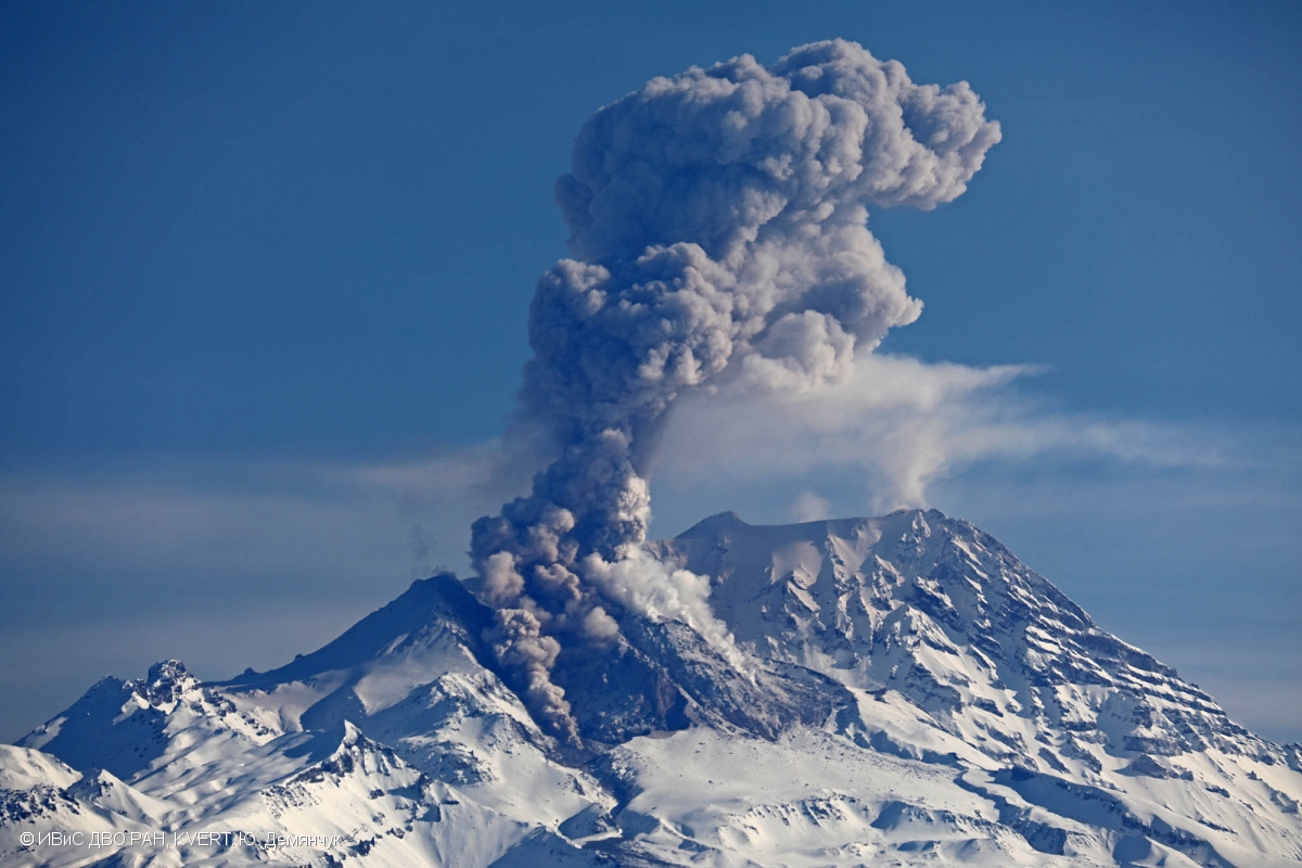
Kamchatka , Sheveluch :
VOLCANO OBSERVATORY NOTICE FOR AVIATION (VONA)
Issued: July 16 , 2022
Volcano: Sheveluch (CAVW #300270)
Current aviation colour code: ORANGE
Previous aviation colour code: orange
Source: KVERT
Notice Number: 2022-75
Volcano Location: N 56 deg 38 min E 161 deg 18 min
Area: Kamchatka, Russia
Summit Elevation: 3283 m (10768.24 ft), the dome elevation ~2500 m (8200 ft)
Volcanic Activity Summary:
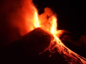
A growth of the lava dome continues, a strong fumarolic activity, and an incandescence of the lava dome, explosions, and hot avalanches accompanies this process. Video and satellite data by KVERT showed an ash plume up to 4.5 km a.s.l. extending to the east from the volcano.
The extrusive eruption of the volcano continues. Ash explosions up to 10-15 km (32,800-49,200 ft) a.s.l. could occur at any time. Ongoing activity could affect international and low-flying aircraft.
Volcanic cloud height:
4500 m (14760 ft) AMSL Time and method of ash plume/cloud height determination: 20220716/2100Z – Himawari-8
Other volcanic cloud information:
Distance of ash plume/cloud of the volcano: 50 km (31 mi)
Direction of drift of ash plume/cloud of the volcano: E / azimuth 82 deg
Time and method of ash plume/cloud determination: 20220716/2100Z – Himawari-8
Source : Kvert.
Photo : Volkstat ru.
Indonesia , Anak Krakatau :
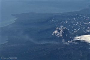
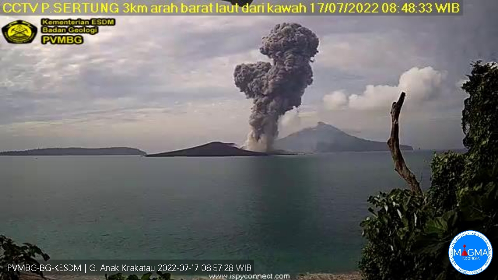
Mount Anak Krakatau erupted on July 16 and 17, 2022. The second at 08:47 WIB with an ash column height observed at ± 2000 m above the summit (± 2157 m above sea level). It is observed that the ash column is gray / black with a thick intensity, oriented towards the South. This eruption was recorded on a seismograph with a maximum amplitude of 56 mm and a duration of 79 seconds.
VOLCANO OBSERVATORY NOTICE FOR AVIATION – VONA
Issued : July 16 , 2022
Volcano : Anak Krakatau (262000)
Current Aviation Colour Code : ORANGE
Previous Aviation Colour Code : orange
Source : Anak Krakatau Volcano Observatory
Notice Number : 2022KRA62
Volcano Location : S 06 deg 06 min 07 sec E 105 deg 25 min 23 sec
Area : Lampung, Indonesia
Summit Elevation : 502 FT (157 M)
Volcanic Activity Summary :
-Eruption with ash clouds at 16h39 UTC (23h39 local time). The eruption lasted for 35 seconds.
-Eruption with ash clouds at 01:47 UTC (08:47 local time). The eruption lasted for 79 seconds.
Volcanic Cloud Height :
Best estimate of ash-cloud top is around 5302 FT (1657 M) above sea level, may be higher than what can be observed clearly. Source of height data: ground observer.
Other Volcanic Cloud Information :
Visuals directly from the cctv were observed eruptions with the color of the thick black eruption smoke 1500m from the top of the volcano, the wind direction slowly to the Northeast.
Remarks :
-Eruption recorded on seismogram with maximum amplitude 50 mm and maximum duration 35 second.
-Eruption recorded on seismogram with maximum amplitude 56 mm and maximum duration 79 second.
Source et photo : Magma Indonésie .
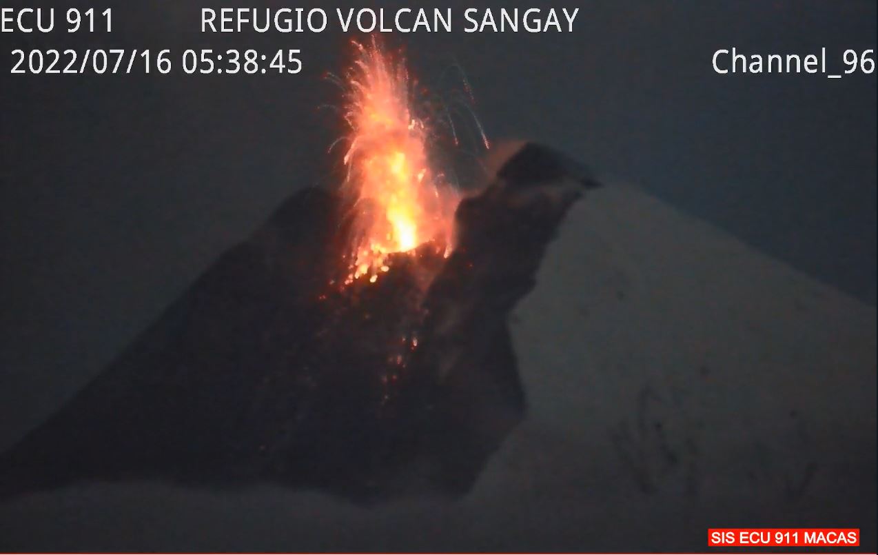
Ecuador , Sangay :
DAILY REPORT OF THE STATE OF SANGAY VOLCANO, Saturday July 16, 2022.
Information Geophysical Institute – EPN.
Surface Activity Level: High, Surface Trend: No change.
Internal activity level: High, Internal trend: No change.
Seismicity: From July 15, 2022, 11:00 a.m. to July 16, 2022, 11:00 a.m.:
Due to technical problems in the reference station, the counting of events was carried out for a duration of 13 hours of operation.
Explosion (EXP) 753
Long Periods (LP) 8
Emission Tremors (TREMI ) 15.
Rains / Lahars:
Light rain was recorded via the Windy app.
Emission / ash column:
Gas and ash emissions were observed up to 1000 meters above the level of the crater in a northwest direction. The Washington VAAC reported gas and ash emissions up to 1,170 meters above the summit, trending west and northwest.
Gas:
The MOUNTS system reported 162.7 tons of SO2, measured on 07/15/2022 at 2:21 p.m. TL.
Other Monitoring Parameters:
FIRMS recorded 16 thermal anomalies, MIROVA reported 1 high (232 MW) and 2 moderate thermal anomalies, over the past 24 hours.
Observation:
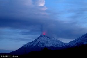
The volcano area was partially cleared this morning, the rest of the time it remained mostly cloudy. Through images from ECU-911, descent of incandescent material was observed on the southeast flank. In addition, no ash fall report was received.
Alert level: Orange.
Source et photo : IGEPN.
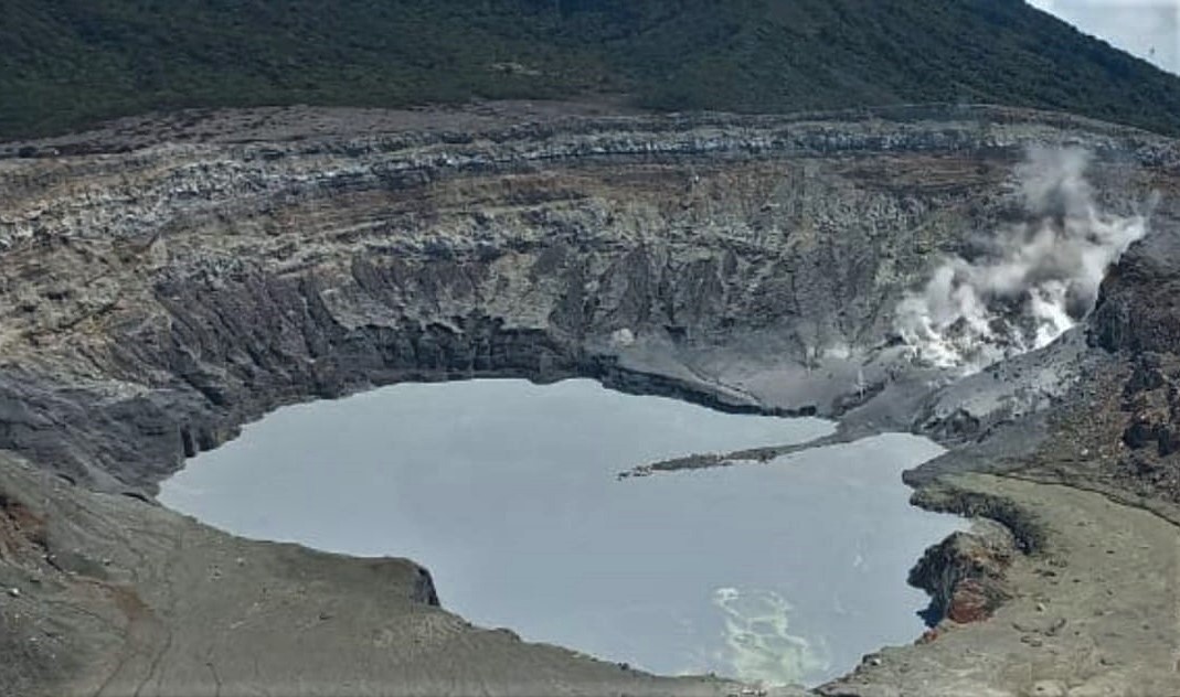
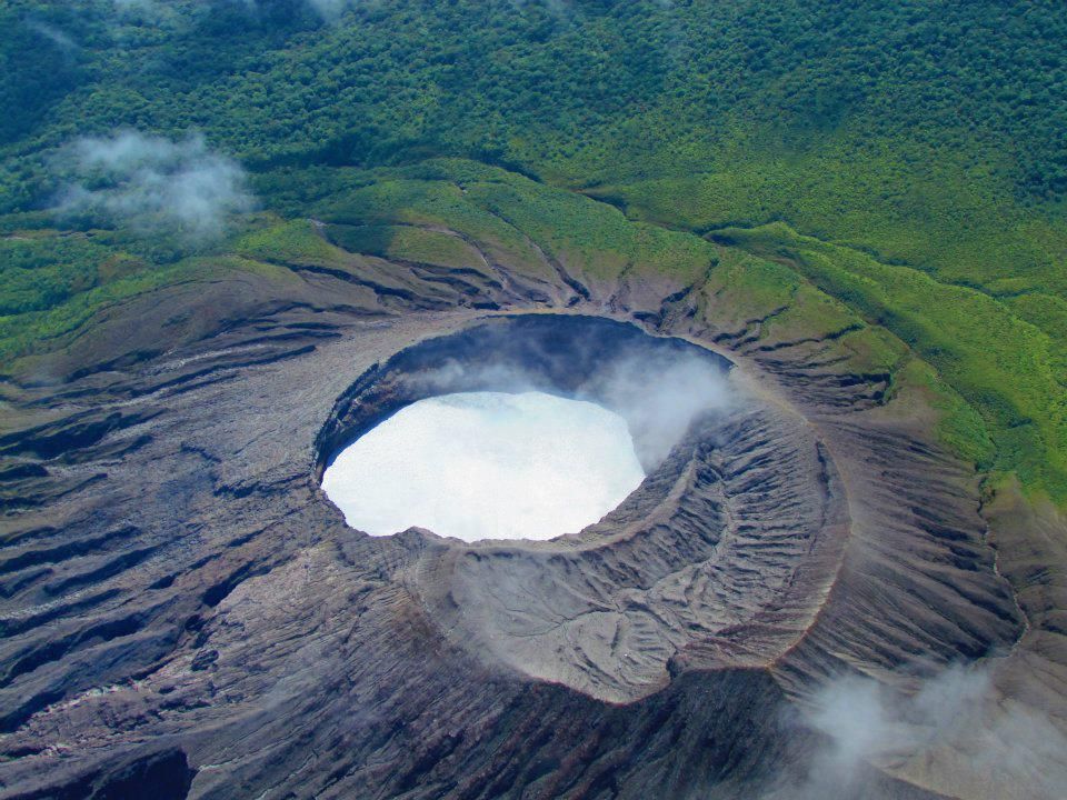
Costa Rica , Turrialba / Poas / Rincon de la Vieja / Irazu :
Turrialba Volcano
Latitude: 10.025°N; Longitude: 83.767°W;
Altitude: 3340 m above sea level
Current activity level: warning
Possible events: Small eruptions, bubbling or geyser, significant emission of acid gases, rise in temperature (incandescence), seismic swarms or volcanic tremor, slight inflation-extension of the volcanic edifice.
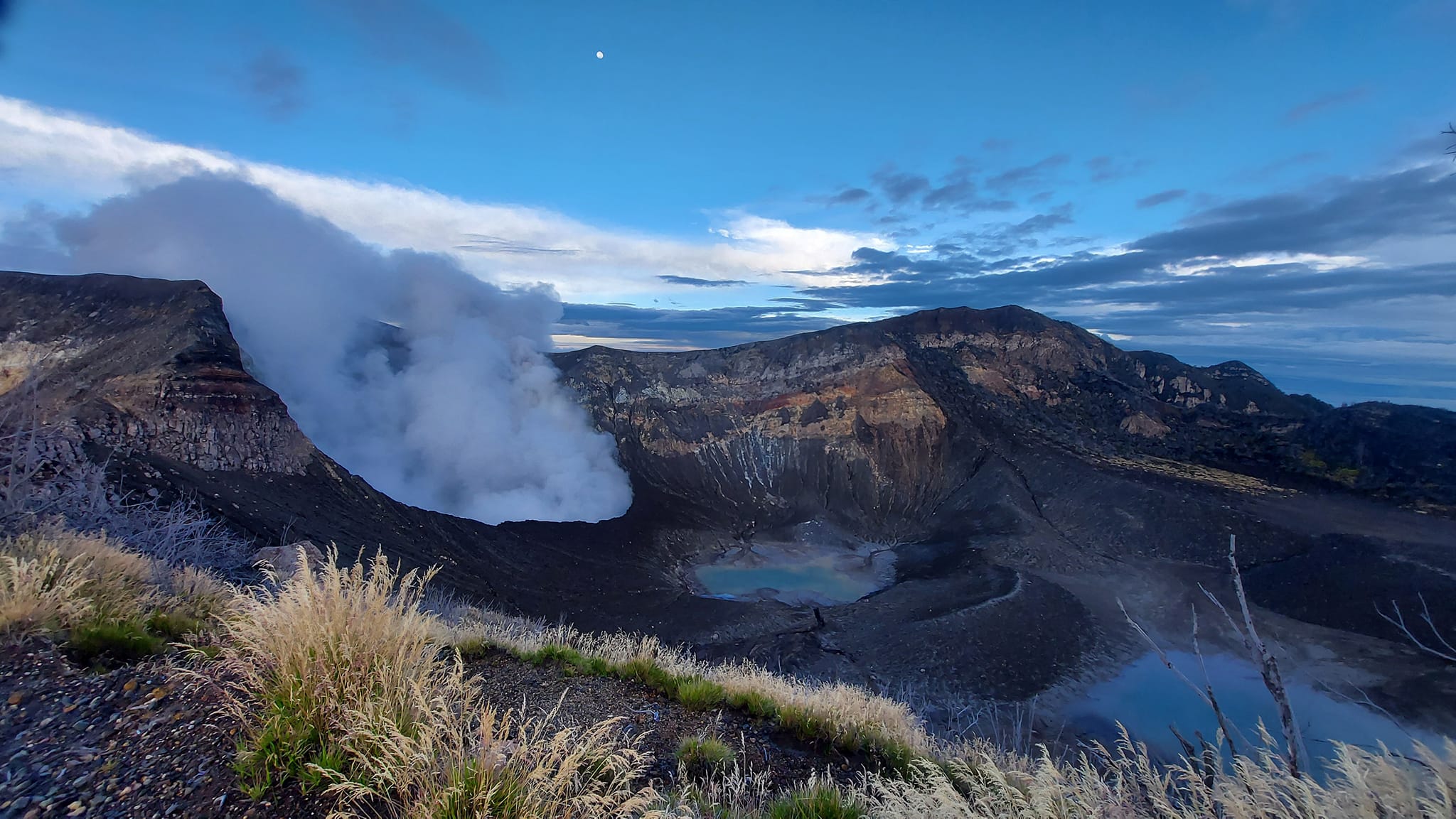
The last phreatic eruption occurred on February 27. Seismic activity remains stable, similar to previous weeks. Geodetic monitoring shows that the Irazú-Turrialba massif continues with a tendency to deflation. The SO2 flux has a weekly average of 247 +/- 129 t/d, a value similar to the previous week.
Poas Volcano
Latitude: 10.2°N; Longitude: 84.233°W;
Altitude: 2780 m above sea level
Current activity level: warning
Possible events: Small eruptions, bubbling or geysers, significant emission of acid gases, rise in temperature (incandescence), seismic swarms or volcanic tremor, slight inflation-extension of the volcanic edifice.
Seismic activity remains stable at a low level. The geodetic network shows slight subsidence and no definite horizontal displacement. The SO2/CO2 ratio has a weekly average of 0.28 +/- 0.12 stable, and the H2S/SO2 ratio has a weekly average of 0.01 +/- 0.005, stable at a low level. The SO2 flux measured with the DOAS station has a weekly average of 96 +/- 43 t/d, a value similar to the previous week. The maximum SO2 concentration at the lookout was around 4 ppm over the past week. The level of the lake has risen about 40 cm during the week, the lake is about to expand on the Playón. Despite the extension of the lake, it maintains a high temperature of around 42°C. A small landslide was observed from the southern rim of the crater generating a small wave in the lake on July 5, around 8:20 a.m.
Rincon de la Vieja Volcano
Latitude: 10.83°N; Longitude: 85.324°W;
Altitude: 1895m.
Current activity level: warning
Possible events: Small eruptions, bubbling or geysers, significant emission of acid gases, rise in temperature (incandescence), seismic swarms or volcanic tremor, slight inflation-extension of the volcanic edifice.
The last eruption was on June 27. Seismic activity continues to decline. No tremor recorded, the RSAM is very low, disappearance of VT type events, then disappearance of « tornillos » type events and LPs. Geodetic monitoring does not show a clear pattern of deformation. The flow of SO2 is maintained with a baseline around 50 t/d, the weather did not allow many measurements to be made.
Irazu Volcano
Latitude: 9.979°N; Longitude: 83.852°W;
Altitude: 3432 m above sea level
Current activity level: Calm
Possible events: tectonic earthquakes, occasional low frequency earthquakes, hydrothermal activity (fumaroles, diffuse gas, hot springs, etc.).

Two small landslides were recorded in the towers sector on July 5 and the Channel 23 antenna was reportedly affected. The permanent GNSS monitoring station of the main landslide in the antenna sector does not show any significant acceleration. The CO2 concentration in the diffuse degassing zone on the northern flank of the volcano shows a decreasing value (517 +/- 10 ppm).
Source : Ovsicori.
Photos : Parque Nacional, Max Arturo Castillo , , Raul Mora / RSN / UCR , Herediahoy.com.
Mexico , Popocatepetl :
July 16, 11:00 a.m. (July 16, 4:00 p.m. GMT)
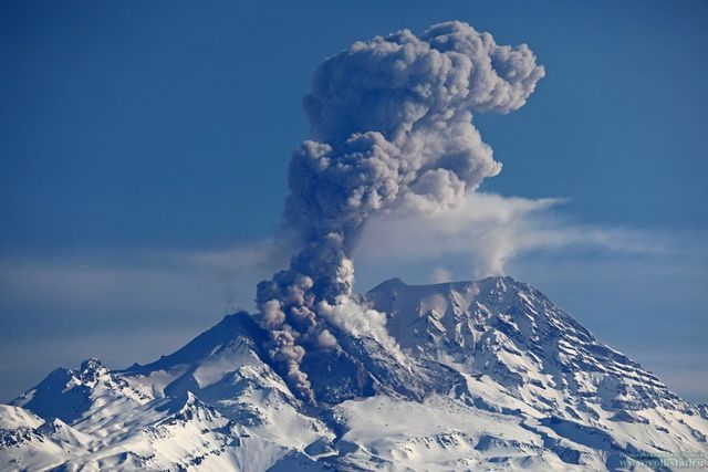
During the last 24 hours, according to the monitoring systems of the Popocatépetl volcano, 39 low intensity exhalations have been detected, accompanied by water vapor and volcanic gases. In addition, 20 minutes of low amplitude tremor were recorded.
During the morning and at the time of this report, the continuous emission of water vapor and gas which disperses in a West-Northwest direction was observed.
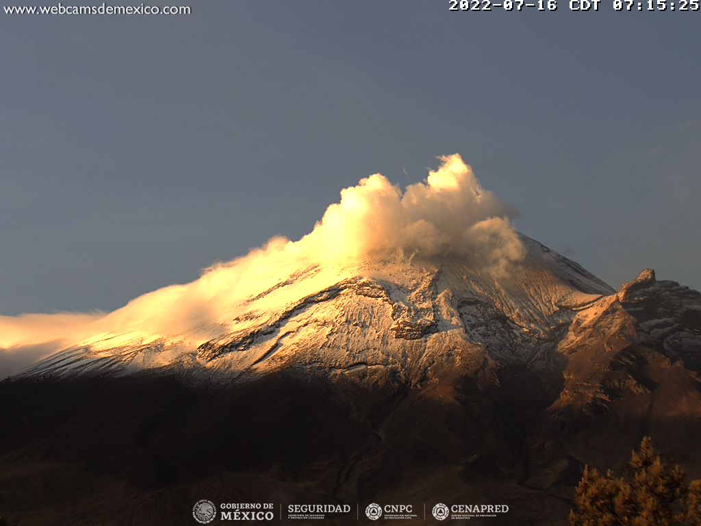
CENAPRED urges NOT TO APPROACH the volcano and especially the crater, because of the danger of falling ballistic fragments and, in case of heavy rains, to stay away from the bottom of the ravines because of the danger of mudslides and of debris.
The Popocatépetl volcanic alert traffic light is in YELLOW PHASE 2.
Source et photo: Cenapred.