October 24 , 2022.
Kamchatka , Bezymianny :
VOLCANO OBSERVATORY NOTICE FOR AVIATION (VONA)
Issued: October 23 , 2022.
Volcano: Bezymianny (CAVW #300250)
Current aviation colour code: RED
Previous aviation colour code: orange
Source: KVERT
Notice Number: 2022-143
Volcano Location: N 55 deg 58 min E 160 deg 35 min
Area: Kamchatka, Russia
Summit Elevation: 2882 m (9452.96 ft)
Volcanic Activity Summary:
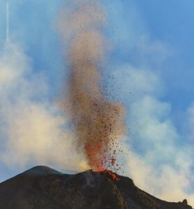
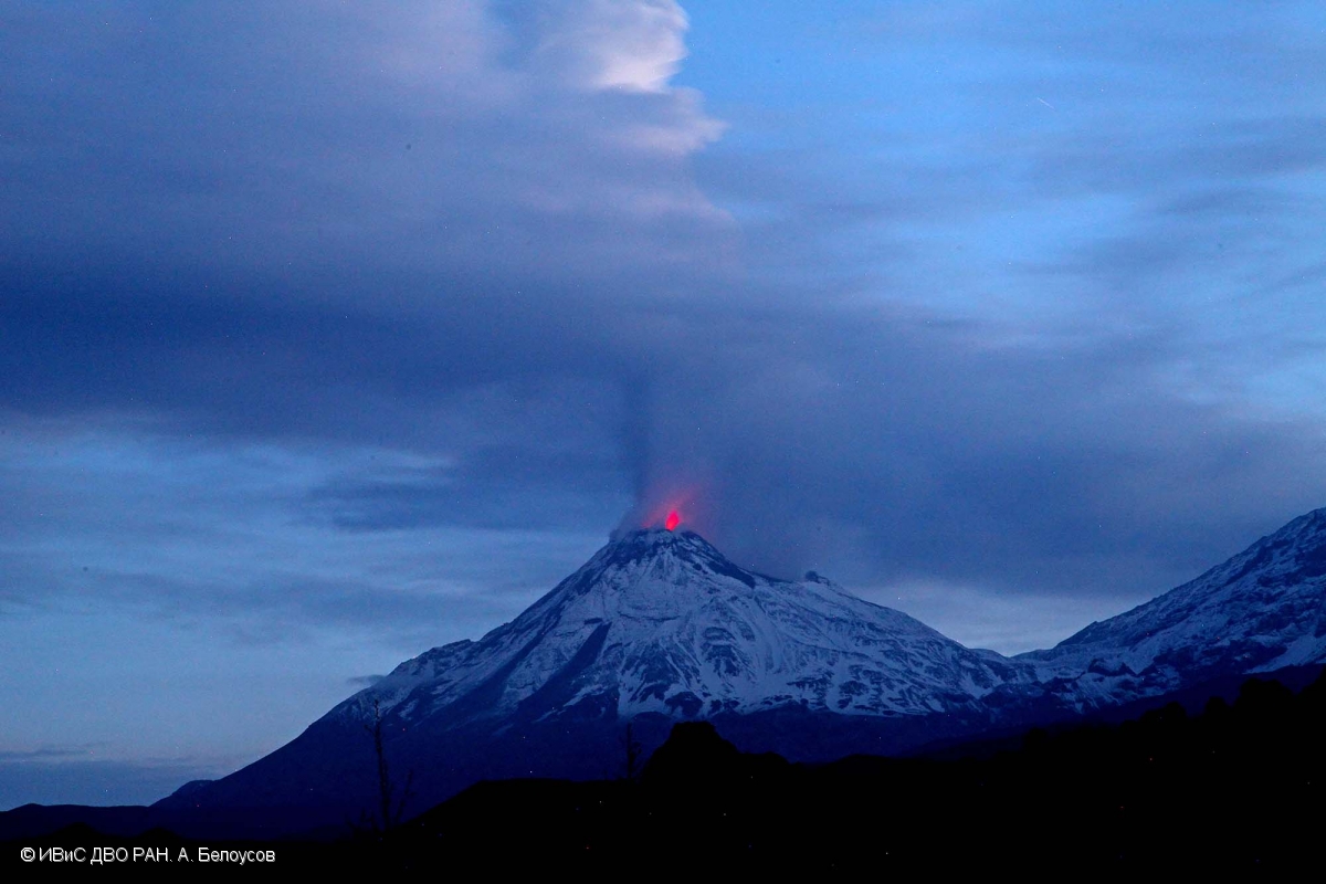
The strong explosive eruption of the volcano occurr. Explosions sent ash up to 10 km a.s.l., ash plume extended to the east of the volcano.
The explosive eruption of the volcano continues. Ongoing activity could affect international and low-flying aircraft.
Volcanic cloud height:
10000 m (32800 ft) AMSL Time and method of ash plume/cloud height determination: 20221023/1140Z – Himawari-8 14m15
Other volcanic cloud information:
Distance of ash plume/cloud of the volcano: 10 km (6 mi)
Direction of drift of ash plume/cloud of the volcano: ENE / azimuth 78 deg
Time and method of ash plume/cloud determination: 20221023/1140Z – Himawari-8 14m15
Source : Kvert.
Photo : A. Belousov, IVS FEB RAS
Ecuador , Cotopaxi :
Information on the activity of the COTOPAXI volcano, SUNDAY OCTOBER 23, 2022.
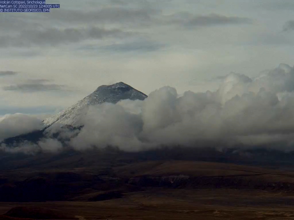
On Sunday, October 23, the summit of the Cotopaxi volcano appeared with a layer of dark gray ash, the result of emissions from the previous days. This photo taken today by the Sincholagua camera shows the summit of Cotopaxi. The October 21 emissions were accompanied by a seismic signal called a volcanic tremor, which lasted 4 hours and then decreased in intensity in the early hours of October 22.
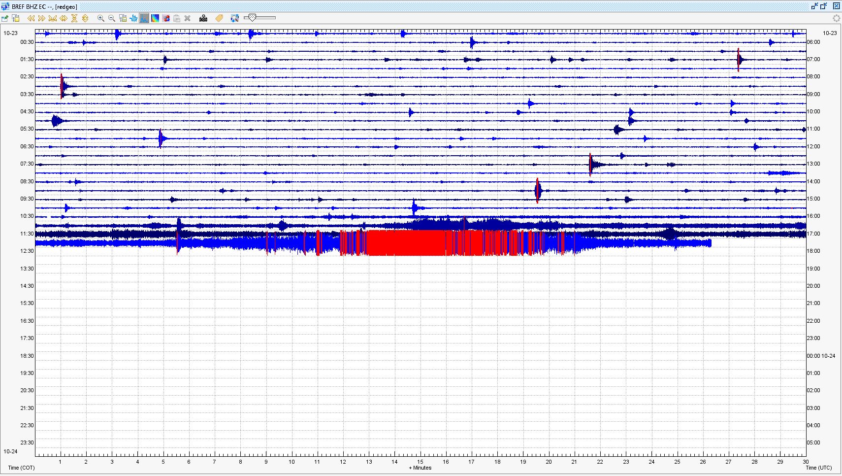
Since yesterday morning until now, the level of seismicity in the Cotopaxi has dropped, as shown in the attached image of the recording of the seismic station of the Refuge (BREF). The Geophysical Institute maintains permanent monitoring of the activity of the volcano and will inform of changes in due course.
Information on the activity of the COTOPAXI volcano, SUNDAY OCTOBER 23, 2022.
Since 11:15 am today, a high frequency tremor signal has been recorded at the BREF seismic station. Other stations located on the northern flank record this signal. Due to the frequencies and amplitudes of the track, it is possible that it is related to small secondary lahars which are caused by the weathering of the ice cap by the ash mantle that now sits atop.
The park wardens of the Cotopaxi National Park are vigilant about the possible descent of these secondary flows and are in communication with the IGEPN.
SUNDAY OCTOBER 23, 2022
Some media reported that there were lahars on the Cotopaxi volcano today. It is true that the high frequencies associated with seismic tremor recorded by our instrumental monitoring network suggest the descent of lahars (flows of water and debris on the flanks of a volcano). Frequencies were above 10 Hz and even up to 50 Hz, which is a common level for lahars.
The lahars that were generated between 11:15 a.m. and 1:00 p.m. today were of the SECONDARY type. This means that they were not co-eruptive. Rather, they are the product of a limited thaw of the snow/glacier layer which is now covered by a layer of ash. This layer of ash facilitates the melting of a surface fraction of the ice, generating water which mixes with the debris in its path to generate small lahars. These flows were short-range and did not reach nearby rivers, such as the Cutuchi and the Pita.
Tomorrow, a commission of engineers from the Geophysical Institute will visit the mouths of the ravines on the northeast flank of the Cotopaxi volcano to verify the presence or absence of secondary lahar deposits and take the necessary measures.
Source et photos :IGEPN.
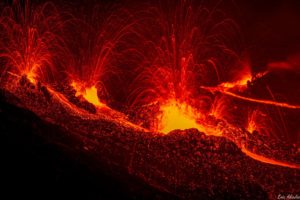
Iceland , Katla :
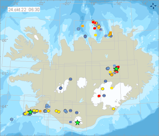
Tonight at 00:46 a M3.7 earthquake was measured in southern Mýrdalsjökull glacier / Katla volcano.
Yesterday at 09:59 a M3.1 earthquake was detected east of Sýlingafell on Reykjanesskagi.
On October 22nd at 23:11 a earthquake M4.1 was measured just north of Mt. Herðubreið. IMO received reports that the earthquake was felt in the town of Akureyri. Since then numerous earthquakes have been detected in the area and IMO’s automatic detection network has located more than 1000 earthquakes in the area.
Week overview 10 October – 16 October
Around 900 earthquakes were located last week by the automatic SIL seismic network, of which about 575 earthquakes have been manually detected. This is an increase in seismicity since last week where about 420 earthquakes were detected. This is due to a seismic swarm east of Grímsey and on Reykjaneshrygg. The largest earthquake of the week was a M4.4 on the 16th of October at 22:11 and was located on Reykjaneshrygg. A total of three earthquakes were detected over M4 in this week, all on Reykjaneshrygg. There was also increased activity in Grímsvötn and in Mýrdalsjökull.
Travelers to Grímsfjall should check that a fairly large crack has opened up halfway up the road east of the mountain, between drive points often referred to as A1 and A2.
It’s not a small crack but a crevice that could easily engulf cars. It would be advisable to drive a bit south of the traditional route up the hill.
Source : Vedur is
Photos : Vedur is , Andri Gunnarsson.
Hawaii , Kilauea :
19°25’16 » N 155°17’13 » W,
Summit Elevation 4091 ft (1247 m)
Current Volcano Alert Level: WATCH
Current Aviation Color Code: ORANGE
Activity Summary:
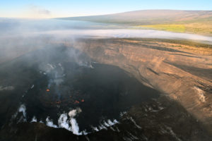
The summit eruption of Kīlauea Volcano, within Halemaʻumaʻu crater, continued over the past 24 hours. All recent eruptive activity has been confined to the crater. No significant changes have been observed at the summit or in either rift zone.
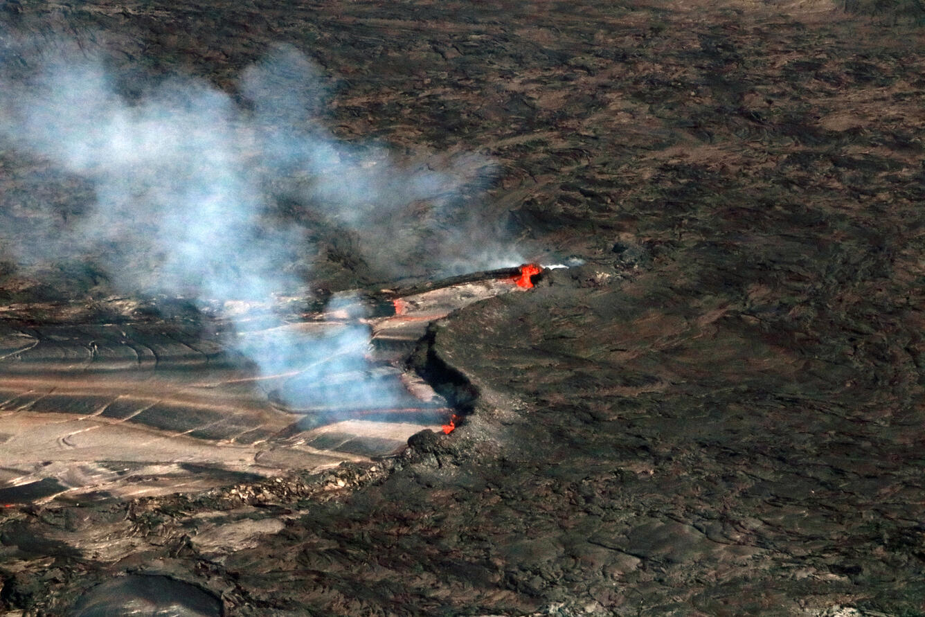
Halemaʻumaʻu Lava Lake Observations:
Eruption of lava from the western vent into the active lava lake and onto the crater floor continued over the past 24 hours. The active part of the lava lake has been steady over the past 24 hours. Overflight measurements from October 5, 2022, indicated that the crater floor had seen a total rise of about 143 meters (469 feet), and that 111 million cubic meters (29.2 billion gallons) of lava had been effused since the beginning of this eruption on September 29, 2021.
Summit Observations:
Summit tiltmeters recorded no appreciable deformation over the last 24 hours. Volcanic tremor remains above background levels. A sulfur dioxide (SO2) emission rate of approximately 1,800 tonnes per day (t/d) was measured on September 30, 2022.
Rift Zone Observations:
No unusual activity has been noted along the East Rift Zone or Southwest Rift Zone; low rates of ground deformation and seismicity continue along both. Measurements from continuous gas monitoring stations downwind of Puʻuʻōʻō in the middle East Rift Zone remain below detection limits for SO2, indicating that SO2 emissions from Puʻuʻōʻō are negligible.
Source : HVO.
Photo : UGSS / K. Mulliken.
Alaska , Semisopochnoi :
51°55’44 » N 179°35’52 » E,
Summit Elevation 2625 ft (800 m)
Current Volcano Alert Level: ADVISORY
Current Aviation Color Code: YELLOW
Low-level eruption at Semisopochnoi volcano is currently paused. No explosions or significant seismic activity were detected over the past day. Clouds obscured most satellite and web camera views over the past day.
Small eruptions producing minor ash deposits within the vicinity of the active north crater of Mount Cerberus and ash clouds usually under 10,000 ft (3 km) above sea level have characterized the recent activity. Small explosions and associated ash emissions could resume and may be difficult to detect during periods of high winds and/or when thick cloud cover obscures the volcano. Ash emissions over the past several years of activity have typically reached altitudes of less than 10,000 ft (3 km) above mean sea level.
Semisopochnoi volcano is monitored by local seismic and infrasound sensors, satellite data, web cameras, and regional infrasound and lightning networks.
Source : AVO.
Photo : Lerner, Allan / Alaska Volcano Observatory / U.S. Geological Survey .