February 26 , 2021 .
Italy / Sicily , Etna :
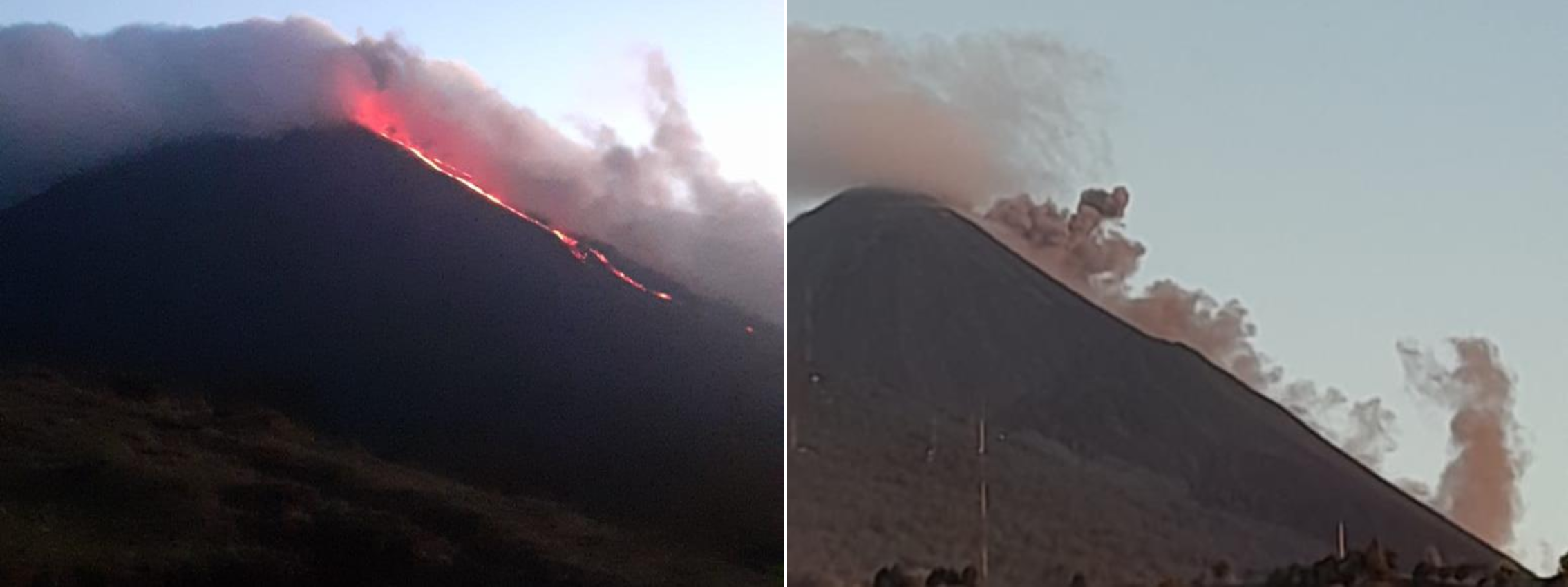
COMMUNICATION ON THE ACTIVITY OF ETNA, 25 February 2021, 12:26 (11:26 UTC).
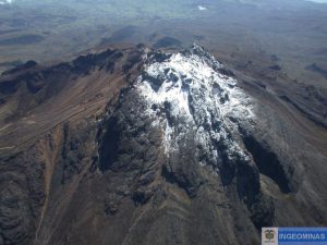
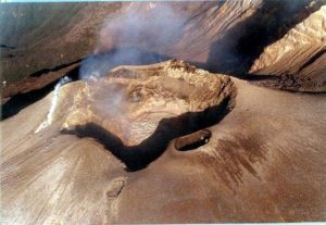
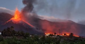
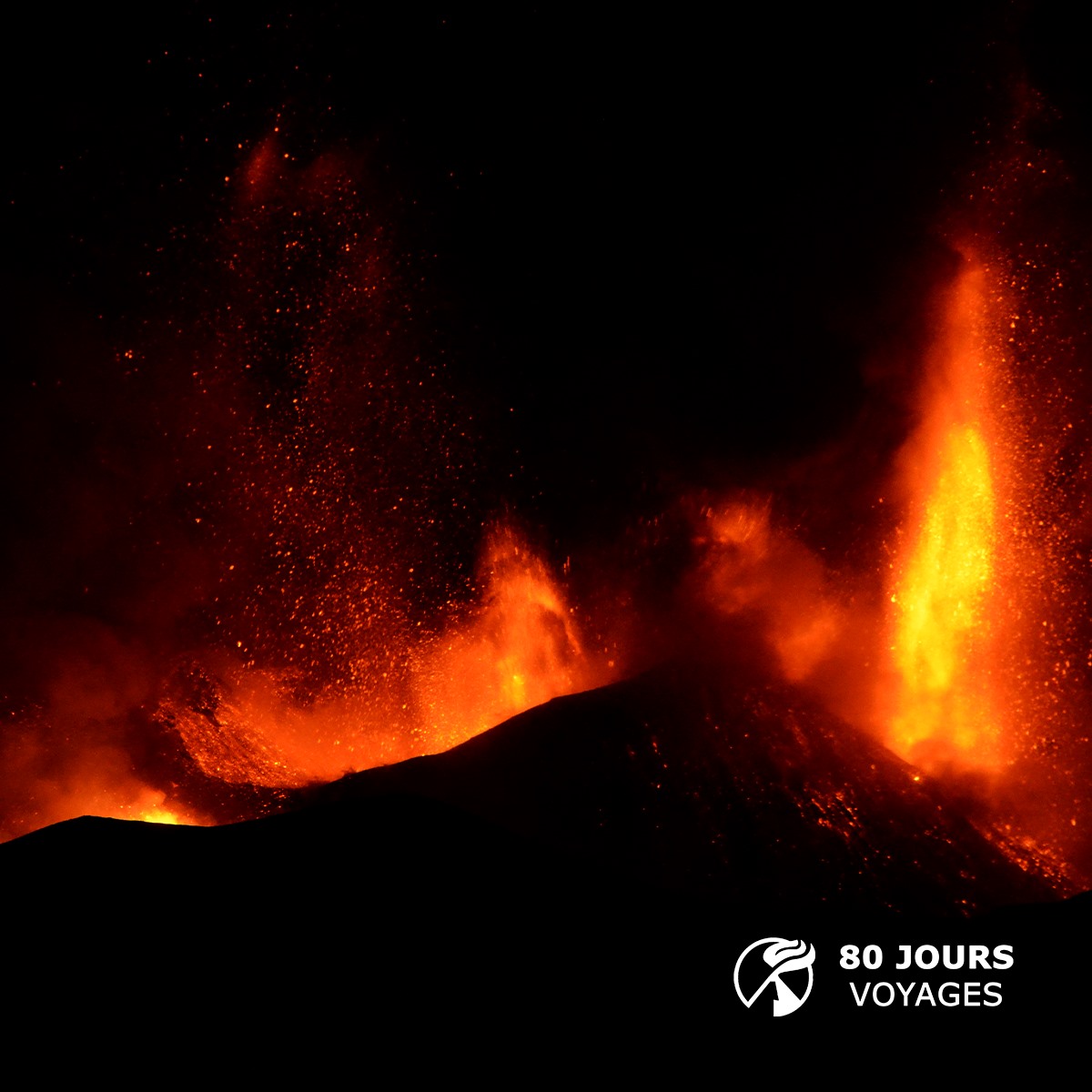
The National Institute of Geophysics and Volcanology, Osservatorio Etneo, announces that at 11:25 a.m. GMT, the eruptive activity at the Southeast Crater has ended. The lava flows are no longer supplied, the fronts of the longest flow of Valle del Bove are cooling. The southwest lava flow has only traveled a few hundred meters overlapping the previous ones. Explosive activity persists in the other craters, where explosive phenomena occur sporadically accompanied by ash emissions, which rapidly disperse into the atmosphere.
The phase of decreasing the average amplitude of the tremor continued until it reached medium-low values in the first hours of the day.
Subsequently, a moderate increase was observed towards average values where it still persists. The source of the tremor is located in the area of the craters of Bocca Nuova and Voragine at a depth of about 2600 m above sea level. From the early hours of the morning, infrasound activity also took off. showed a moderate increase in the number and energy of events, which are located at the Southeast Crater.
Analysis of the inclinometric data showed variations at all stations along with the lava fountain episode of 24, with maximum values (around 2 microradians) recorded at the Cratere del Piano station (ECP). The analysis of the inclinometric signals of the last 12 hours does not show any significant change.
Analysis of GPS network data for the past 24 hours shows fluctuations of an amplitude within the margin of error, and no significant variation is recorded.
Source : INGV.
Photo : Sylvain Chermette / 80 Jours Voyages .
Saint Vincent , Soufrière Saint Vincent :
LA SOUFRIÈRE BULLETIN , FEBRUARY 24, 2021 8:00 PM
The camera set up at the La Soufrière Volcano was replaced.
There are plans in place to install a new seismic station at Bamboo Range on the eastern (Windward) side of the volcano. Equipment for installation is being prepared by the Seismic Research Centre and Soufrière Monitoring Unit Team.
Some maintenance work was done on the equipment installed at NEMO and this station is now fully operational.
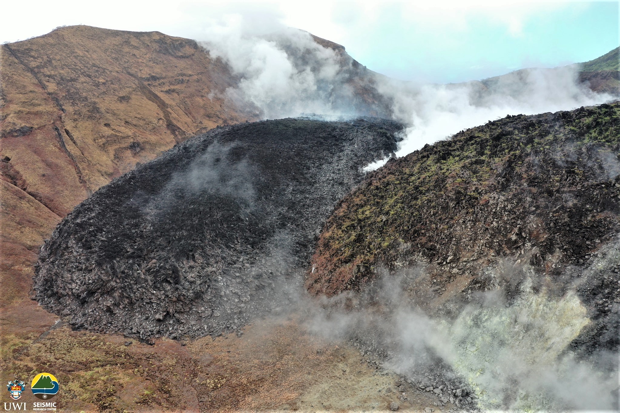
February 12, 2021. View of the new and the old dome. The volume of the dome is now estimated at 6.83 million m3 and 618 m in length, 232 m in width and 90 m in height. Photo: SMU, Kemron Alexander.
NEMO staff will be conducting a drive through in the Rose Bank Community on Friday 26th February 2021. The purpose of this drive through is to update residents on the state of the La Soufrière Volcano, and to provide information on evacuation procedures and individual preparedness.
The National Emergency Management Organisation is reminding the public that no evacuation order or notice has been issued.
NEMO continues to appeal to the public to desist from visiting the La Soufrière Volcano, especially going into the crater, since doing so is extremely dangerous.
Source : Nemo
Philippines , Taal :
TAAL VOLCANO BULLETIN: 26 February 2021 08:00 A.M.
In the past 24-hour period, the Taal Volcano Network recorded one hundred thirteen (113) volcanic tremor episodes having durations of one (1) to thirty-four (34) minutes. Despite these, only weak steam-laden plumes were emitted by fumarolic activity at the vents of the Main Crater. Temperature highs of 74.6°C and pH of 1.59 were last measured from the Main Crater Lake respectively on 18 and 12 February 2021. Ground deformation parameters from continuous electronic tilt on Volcano Island record a slight deflation around the Main Crater since October 2020 but overall, very slow and steady inflation of the Taal region has been recorded by continuous GPS data after the eruption.
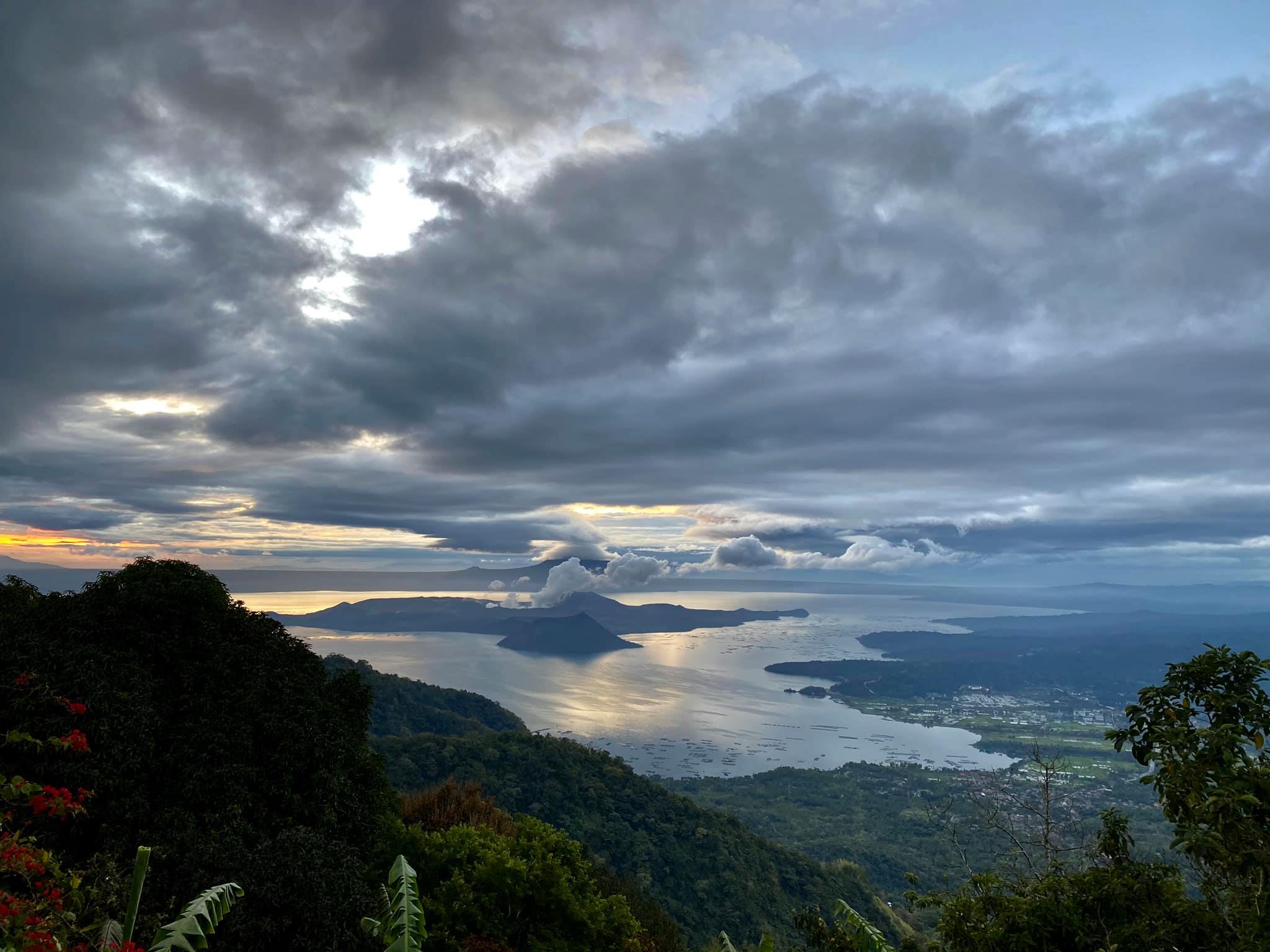
Entry to the island, which is a permanent danger zone, is strictly prohibited.
The National Disaster Risk Reduction and Management Council advised local government units to continuously assess the preparedness of residents of barangays around Taal Lake.
Phivolcs Director Renato Solidum said there is an increasing likelihood of a phreatic eruption but it would be limited to Volcano Island.
Source : Phivolcs , Philstar .
Photo : Raffy Tima.
Indonesia , Merapi :
A hot avalanche cloud occurred on Mount Merapi on February 26, 2021 at 04.39 WIB, recorded on a seismogram with an amplitude of 55mm, and a duration of 130sec. The height of the column was not observed due to the fog. The estimated sliding distance is – + 1500 m towards the southwest.
Level of activity level III (SIAGA) since November 5, 2020 at 12:00 WIB. The Merapi volcano (2968 m altitude) erupted continuously. The last strong eruption took place on June 21, 2020 with the height of the eruption column at 6000 m above the summit. It was observed that the color of the ash column was gray.
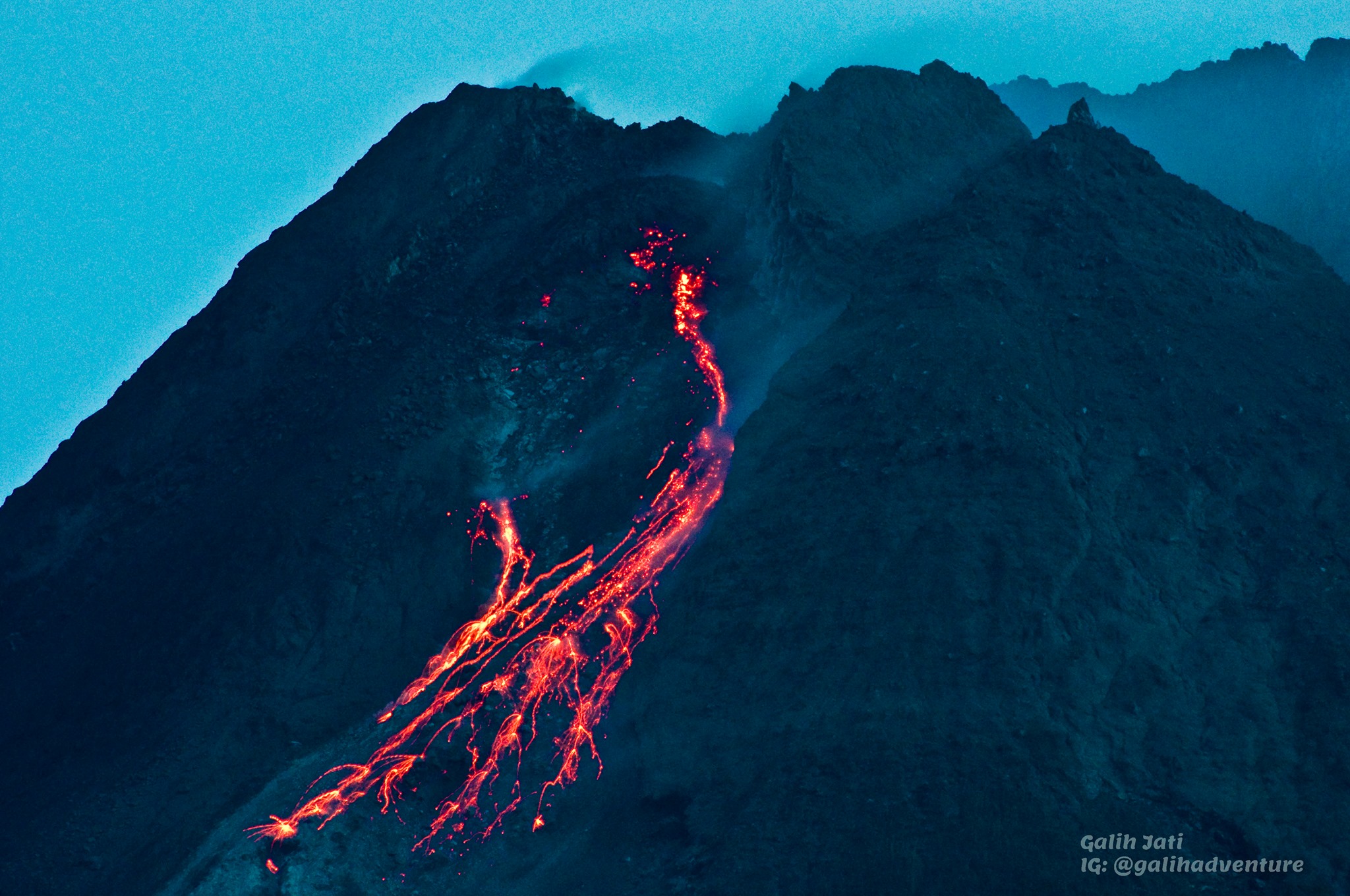
The volcano is clearly visible until it is covered in fog. The crater emits white smoke, of moderate to strong intensity, about 50 meters high from the summit. The weather is sunny to rainy, with weak to strong winds to the east, southeast, south and west. The air temperature is around 27 ° C. Humidity 56-92%. Atmospheric pressure 565-708 mmHg.
According to the seismographs of February 25, 2021, it was recorded:
2 hot cloud avalanche earthquakes
198 avalanche earthquakes
2 emission earthquakes
1 hybrid / multi-phase earthquake.
Source : PVMBG, BPPTKG.
Photo : Yohannes Tyas Galih Jati
Guatemala , Pacaya :
SPECIAL VOLCANOLOGICAL BULLETIN, February 24, 2021, 8:04 p.m. local time
UPDATE OF THE ACTIVITY STATE OF THE PACAYAN VOLCANO
Over the past few days, the amplitude of the seismic signals recorded by the instruments of the stations installed on the Pacaya volcano has shown a notable decrease, as can be seen on the RSAM graph of the PCG5 station in the figure below.
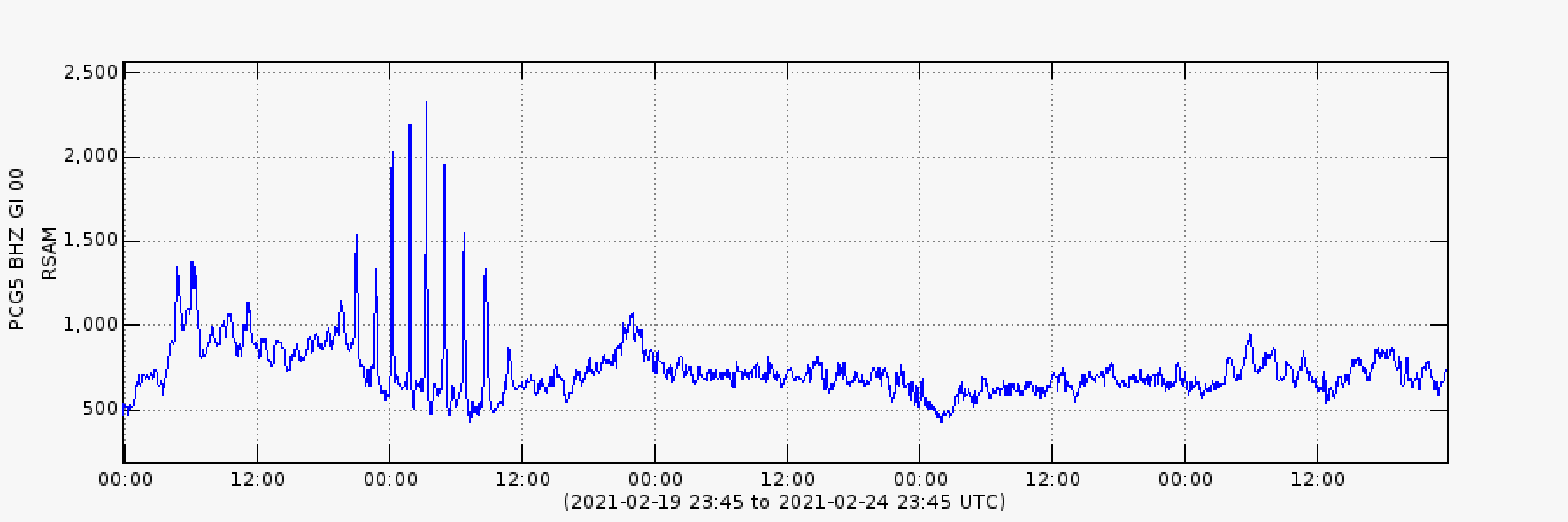
Figure 1. Average of the seismic amplitudes recorded by the PCG5 station over the last 5 days, showing increasing pulses on Saturday afternoon-night, then the decrease and the tendency to maintain a certain level of energy, with slight increases and sporadic.
OVPAC has reported weak to moderate explosions, which raise incandescent material to heights of up to 200 meters above Mackenney Crater. Also sporadic increases in activity, which produced the emission of thick columns of ash from the Mackenney crater, which the strong wind displaces on the southern and southwest flanks, causing ash falls in the villages of Los Pocitos, Pacaya, El Rodeo and El Patrocinio. These disperse in a south and southwest direction at distances greater than 30 kilometers. Effusive activity is maintained on the southern flank, with an active lava flow that originates 300 meters below the crater and reaches a length of 1,100 meters, on the course of which and especially in the front there are avalanches. constants of incandescent blocks which descend to 300 meters beyond the flow front.
It is not excluded that the volcanic activity generates new pulses of increase in the hours or the next days, which produce more emissions of ash columns, explosions with ballistic projections, as well as the increase of the length or emergence of new lava flows. on the flanks around the volcanic cone.
INSIVUMEH provides visual and instrumental monitoring of volcanic activity using seismic stations and field observers.
Source : Insivumeh .