August 25 , 2023.
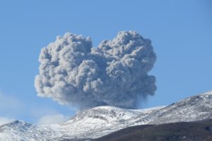
Colombia , Chiles / Cerro Negro :
Weekly activity bulletin of the Chiles and Cerro Negro Volcanic Complex (CVCCN)
Regarding the monitoring of the activity of the CHILES AND CERRO NEGRO VOLCANOES, the MINISTRY OF MINES AND ENERGY, through the COLOMBIAN GEOLOGICAL SERVICE (SGC), reports that:
For the period from August 15 to 21, 2023 and compared to the immediately preceding weeks, the seismic activity continues to gradually decrease compared to the seismic increase that began on August 5, even if it persists at significant levels, especially in terms of ‘occurrence. . The predominance of earthquakes associated with the fracturing of rocks inside the volcanic edifice is maintained, followed by seismicity linked to the movement of fluids.
Earthquakes associated with rock fracturing occurred mainly south of the Chiles volcano, at distances up to 4 km, with depths less than 6 km from its summit (4,700 m altitude) and a maximum magnitude of 2.6. No felt earthquakes were reported.
Deformation processes continue in different sectors of the volcanic edifice, detected instrumentally by sensors installed in the volcanoes as well as by satellite sensors.
The volcanic activity that occurred in the zone of influence of the Chiles–Cerro Negro volcanoes is part of a fluctuating process that has been occurring since late 2013. The most recent increase began on March 9, 2023, with the recording of more of 215,000 earthquakes in the last 5 months, most related to rock fracturing, which show variations mainly in energy levels and which are associated with the complex interaction of the CVCCN magmatic system, the hydrothermal system and the tectonics of the region (geological faults).
The probability of occurrence of energetic earthquakes that can be felt by the inhabitants of the area of influence is maintained.
In this probable context of activity in the CVCCN, the occurrence of earthquakes of greater magnitude may generate instability on the slopes, landslides and structural damage to the infrastructures located in the area, such as buildings, roads access points, bridges, etc. These aspects must continue to be taken into account by the authorities and communities residing in the area of influence of these volcanoes.
The activity level of the volcanoes remains at:
YELLOW LEVEL ■ (III): CHANGES IN THE BEHAVIOR OF VOLCANIC ACTIVITY
Source : SGC
Photo : Ingeominas
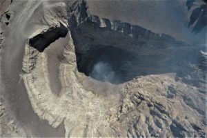
Hawaii , Kilauea :
Thursday, August 24, 2023, 9:41 AM HST (Thursday, August 24, 2023, 19:41 UTC)
19°25’16 » N 155°17’13 » W,
Summit Elevation 4091 ft (1247 m)
Current Volcano Alert Level: ADVISORY
Current Aviation Color Code: YELLOW
Activity Summary:
Kīlauea volcano is not erupting. Kīlauea summit is currently exhibiting signs of elevated unrest. No unusual activity has been noted along Kilauea’s East Rift Zone or Southwest Rift zone.
Summit Observations:
Elevated, swarm-like, seismic activity continues at Kīlauea’s summit, concentrated in an area south of the summit caldera. Most earthquakes have been at a depth of 1-2 miles (2-3 km) below the surface, with no upward migration. The recent general trend of inflationary tilt on summit tiltmeters continued through the past day, but with some variability. The earthquake activity and tiltmeter data indicate that Kīlauea summit is becoming increasingly pressurized. Similar episodes of earthquake and ground deformation activity occurred in November 2020 and August 2021, prior to eruptions in December 2020 and September 2021. The activity is currently confined within Kīlauea summit region and if it continues, could escalate to an eruption in the coming days, weeks, or months. The activity could also decrease due to intrusion of magma underground or other changes, resulting in no eruption. Furthermore, levels of activity may continue to rise and fall during this period. Sulfur dioxide (SO2) emissions from the summit remain low; the most recent SO2 emission rate, of approximately 86 tonnes per day, was measured on August 15.
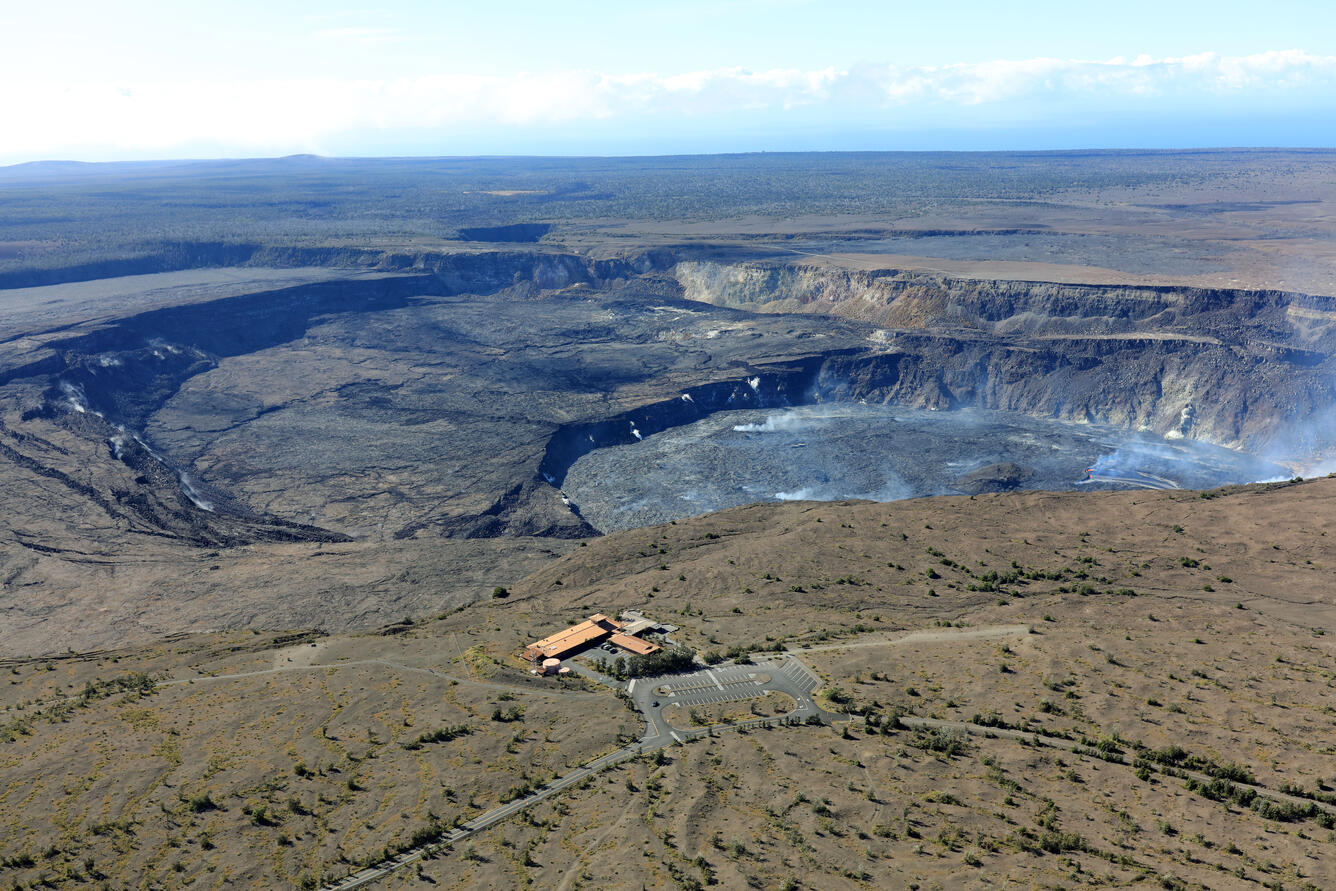
Halemaʻumaʻu crater Observations:
No active lava has been observed since June 19.
East Rift Zone Observations:
No unusual activity has been noted along the East Rift Zone or Southwest Rift Zone; steady rates of ground deformation and seismicity continue along both. Measurements from continuous gas monitoring stations downwind of Puʻuʻōʻō in the middle East Rift Zone remain below detection limits for SO2, indicating that SO2 emissions from Puʻuʻōʻō are negligible.
Source : HVO
Photo : USGS / K. Mulliken ( archive).
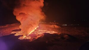
Philippines , Mayon :
MAYON VOLCANO BULLETIN 25 August 2023 8:00 AM
In the past 24-hour period, slow effusion of lava from the summit crater of Mayon Volcano continued to feed the established lava flows on the Bonga (southeastern), Mi-isi (south), and Basud (eastern) gullies. The lava flows have maintained their respective advances to approximately 3.4 kilometers, 2.8 kilometers, and 1.1 kilometers from the crater. Rockfall and pyroclastic density currents or PDCs generated by collapses of the lava flow margins as well as of the summit dome deposited debris still within four (4) kilometers of the crater. The Mayon Volcano Network recorded a total of fifteen (15) volcanic earthquakes including fourteen (14) tremor events lasting three (3) to thirty-six (36) minutes. Additionally, the network detected one hundred fifty-six (156) rockfall events and six (6) PDC events.
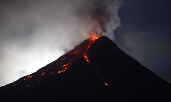
Volcanic sulfur dioxide (SO2) emission averaged 735 tonnes/day on 23 August 2023. Short-term observations from electronic tilt and GPS monitoring indicate pronounced inflation of southeastern middle slopes since the beginning of August 2023. Longer-term ground deformation parameters from EDM, precise leveling, continuous GPS, and electronic tilt monitoring indicate that Mayon is still generally inflated relative to baseline levels.
Alert Level 3 is maintained over Mayon Volcano, which means that it is currently in a relatively high level of unrest and hazardous eruption within weeks or even days could still be possible.
Source : Phivolcs
Photo : Auteur inconnu
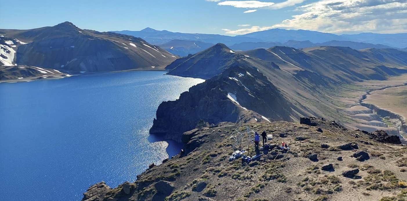
Chile , Laguna del Maule :
Seismology
The seismological activity of the period was characterized by the recording of:
920 VT type seismic events, associated with rock fracturing (Volcano-Tectonic type). The most energetic earthquake presented a value of Local Magnitude (ML) equal to 3.5, located 8.4 km south-south-west of the center of the lagoon, at a depth of 1.7 km compared to the average height of the lagoon.
4 LP-type seismic events, associated with fluid dynamics within the volcanic system (Long Period type). The size of the largest earthquake, evaluated from the Reduced Displacement (DR) parameter, was equal to 1.3 cm2.
1 HB-type seismic event, associated with both rock fracturing and fluid dynamics within the volcanic system (Hybrid). This earthquake presented a reduced displacement value (DR) of 49 cm2 and a local magnitude value (ML) equal to 2.3, located 9 km southwest of the Barrancas volcanic complex, southeast sector of Laguna del Maule.
Fluid Geochemistry
No anomalies in sulfur dioxide (SO2) emissions into the atmosphere have been reported in the area near the volcanic complex, according to data published by the Tropopheric Monitoring Instrument (TROPOMI) and the Ozone Monitoring Instrument (OMI) .
Satellite thermal anomalies
During the period, no thermal alert was recorded in the area associated with the volcanic complex, according to the analytical processing of Sentinel 2-L2A satellite images, in combination with false color bands.
Geodesy
The geodetic activity of the period was characterized by:
– Monitoring lines with average rates similar to historical values, observed in the volcanic complex, adjusting a maximum of 1.39 cm / month.
– Horizontal strain rates similar to previous periods, with some minor variations.
– Thanks to satellite radar interferometry, no signal associated with deformation due to the heavy presence of snow in the area is detected.
Although the seismicity record decreased compared to previous periods, mainly due to a loss of sensitivity of the instrumental network, in the absence of new seismic swarms, 9 energetic volcanotectonic events with ML > 2 occurred. The process of volcanic deformation persists with growth rates similar to those historically recorded, with values in line with the usual averages. Apparently, no change associated with volcanic activity is observed. From the above, it is deduced that the volcanic system still remains above its base threshold, therefore its technical alert remains yellow and a possible assignment radius of 2 km around the anomalous CO2 zone detected in previous years in a sector to the southwest of the lagoon in the Troncoso channel.
YELLOW TECHNICAL ALERT: Changes in volcanic activity behavior
Observation:
The impact zone is considered to be that contained within a radius of 2 km around the passive CO2 degassing zone.
Source : Sernageomin
Photo : neuqueninforma.gob.ar
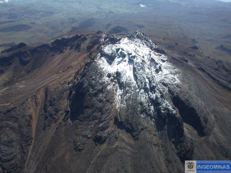
Costa Rica , Platanar-Porvenir-Volcán Viejo :
Technical report OVSICORI-UNA
Platanar-Porvenir-Volcán Viejo volcanic complex. Information related to the July 15, 2023 landslide
Updated August 18, 2023
Preview:
On July 15, 2023 at 10:12 p.m. local time, the OVSICORI-UNA seismographic network recorded a slow translational landslide in the Platanar-Porvenir-Volcán Viejo volcanic complex. After the publication of the preliminary information on July 27, 2023, OVSICORI-UNA conducted a site visit on July 28, allowing photogrammetry of the upper zone of the landslide and a more precise reassessment of the preliminary information.
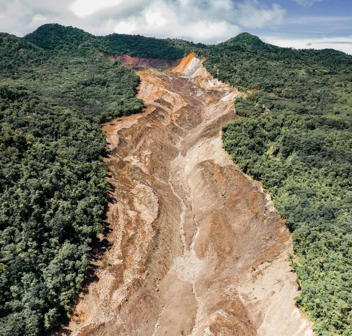
● At 10:12 p.m. (10:12 p.m.) on July 15, 2023, a signal related to a slow translational landslide was detected, preceded by a tectonic tremor which indicates the process of preparation for the rupture of this large landslide.
● The duration of this event was approximately 10 minutes.
● Until July 17, at least 7 other events associated with smaller landslides have been recorded.
● Terrain models of the upper part of the impacted area have been produced using drone flights and 2 areas can be defined:
○ 1) the main landslide area which represents a differential volume of 10 million cubic meters of material over the first 600 m of the affected area and an area of 30 hectares,
these values have an uncertainty of +/-20%, and
○ 2) an erosion area greater than 40 hectares with a differential volume greater than 7 million m3.
● The presence of several lagoons in the affected area has been verified, the largest covered an area of 3,400 m2 without a visible outlet, it could accumulate an additional volume of about 15,000 m3 of water before finding an outlet, according to the terrain model.
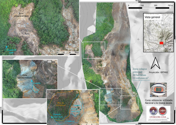
● This lagoon was formed by the accumulation of water behind a block with a volume of 270,000 m3.
● The presence of hydrothermal zones at the limit of the landslide rupture is confirmed, as shown by the geological map of the area.
● A waterlogged area of approximately 6 hectares was discovered adjacent to the landslide area.
● New fractures were observed about 500 meters west of the landslide.
Source et photos : Ovsicori