February 06 , 2021 .
Indonesia , Merapi :
Mont Merapi activity report, from January 29 to February 04, 2021.
OBSERVATION RESULTS
Visual
The weather around Mount Merapi is generally sunny in the morning, while the afternoon until evening is foggy. There is white smoke, thin to thick with low pressure. A maximum smoke height of 100m is observed from the Mount Merapi observation post in Kaliurang on January 31, 2021 at 09:30 WIB.
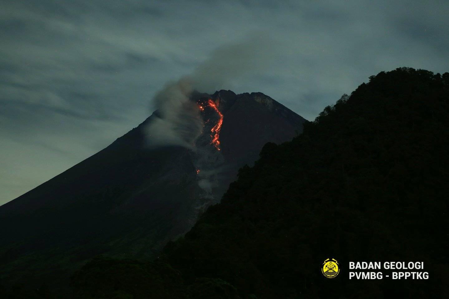
Avalanche of heat clouds occurred once with a sliding distance of 600 meters to the southwest and recorded on a seismogram with a maximum amplitude of 25 mm and a duration of 100 seconds.
On February 4, 2021, the volume of the 2021 lava dome on the Southwest Cliff was measured at 117,400 m3. There was a growth of the lava dome with a growth rate of 12,600 m3 / day. Analysis of the Southeast sector from February 4 to January 26, 2021 shows a change in the morphology of the crater area that is believed to be dome growth.
Seismicity
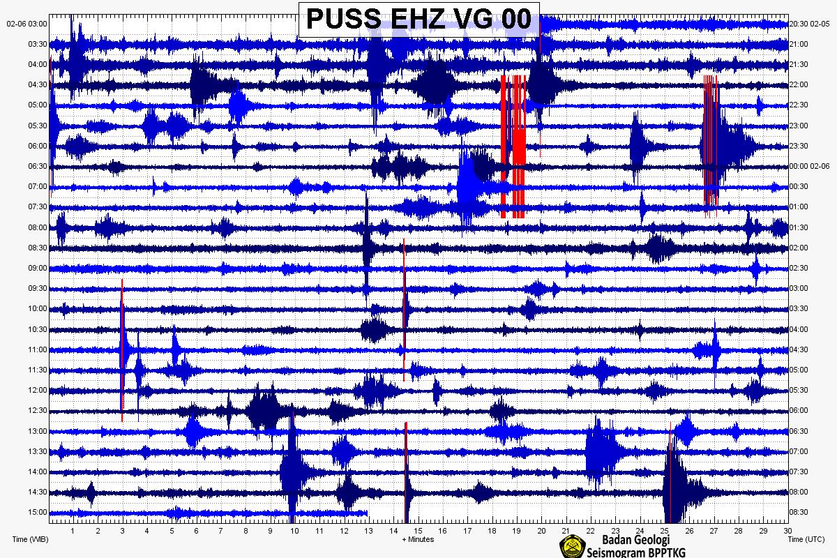
This week, the seismicity of Mount Merapi recorded:
1 hot cloud avalanche earthquake (AP),
31 multi-phase earthquakes (MP),
574 avalanche earthquakes (RF),
14 emission earthquakes (DG)
8 tectonic earthquakes (TT).
The seismic intensity this week is lower than last week.
Deformation
The deformation of Mount Merapi which was monitored using EDM and GPS this week showed no significant changes.
Rain and lahars:
This week there was rain at Mount Merapi Observation Post with the highest rainfall intensity of 111mm / hour for 70 minutes at Kaliurang Post on January 29, 2021. It was reported that there was additional flow into the Boyong River on February 3. 2021.
Conclusion
Based on the results of visual and instrumental observations, it is concluded that:
1. The volcanic activity of Mount Merapi is still quite high in the form of effusive eruption activity. The status of the activity is defined at the “SIAGA” level.
Source : BPPTKG.
Italy / Sicily , Etna :
COMMUNICATION ON THE ACTIVITY OF ETNA [UPDATE n. 125].
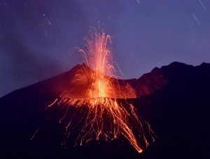
The National Institute of Geophysics and Volcanology, Osservatorio Etneo, announces that the analysis of the images of the surveillance cameras INGV-OE and the observations made by the staff of the INGV during an inspection carried out in the summit area on the 5th February, show that Strombolian activity in the Southeast Crater continues, with a frequency and intensity varying over time. This morning, starting around 04:30 UTC, an intensification of Strombolian activity at the vents present in the eastern summit sector of the cone produced a cloud of diluted ash for about an hour which dispersed to the east.
Intense Strombolian activity continues from various vents present at the bottom of the Bocca Nuova crater, with the launching of material that even exceeds the edge of the crater. Strombolian and effusive activity is observed at the level of the Voragine crater feeding a small intracrater lava flow directed towards the Bocca Nuova. Intra-crater explosive activity at the Northeast Crater also continues. The amplitude of the volcanic tremor, while maintaining high values, does not show significant variations. The location of the source of the tremor and the infrasonic activity are also stationary.
The signals from the soil deformation monitoring stations did not register any significant changes.
Further updates will be communicated shortly.
Source et photo : INGV.
Chile , Nevados of Chillan :
During the period, 244 seismic events classified as being of volcano-tectonic type were recorded, associated with fragile rupture processes in volcanic systems; the most energetic event recorded a local magnitude (ML) value of 3.4 and was located 2 km east of the active crater, with a depth of 3.2 km.
In addition, 1,349 seismic events classified as being of long period type were recorded, associated with the dynamics of fluids present in a volcanic system; the higher with the higher energy obtained a reduced displacement (DR) equal to 360 cm2. Finally, 593 seismic events were classified as type tremor, associated with the sustained dynamics of the fluids present in a volcanic system; the largest of them had a DR value equal to 330 cm2.
– 676 events were identified as discrete explosive activity. The higher energy explosion had a seismic signal associated with a DR equal to 360 cm2.
– According to volcanic surveillance cameras, explosive and effusive activity was recorded during this fortnight.
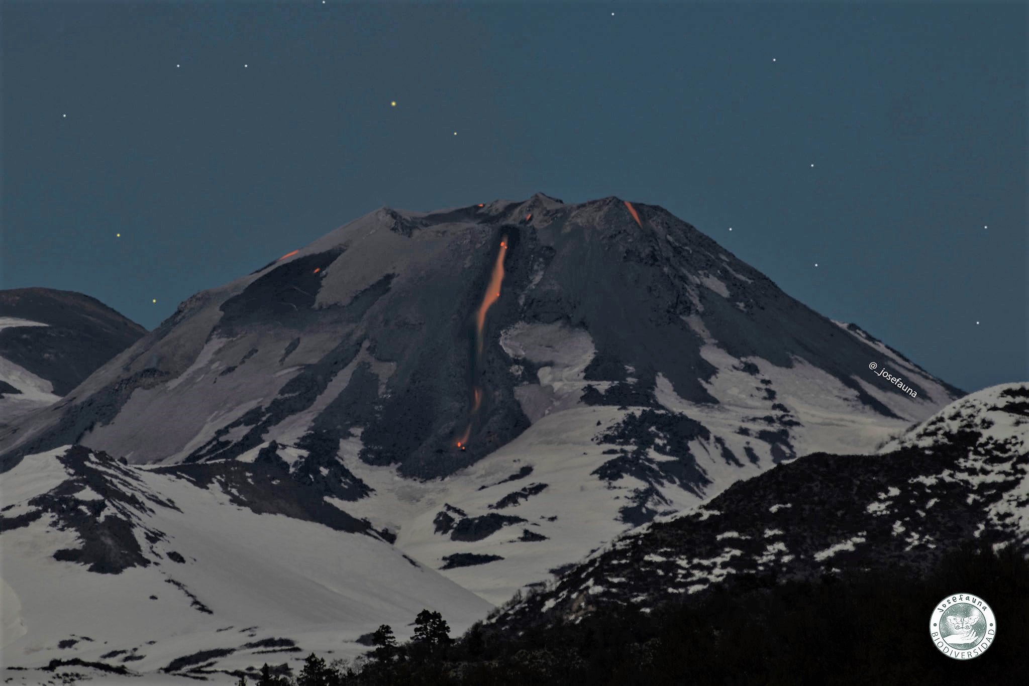
Explosive events are characterized by the generation of eruptive columns less than 1420 m above crater level, with varying particulate matter content. The type of explosive activity coming from the dome is maintained, with the generation of deposits of fragments on the slope, without significant progress, of the order of 1 meter for this fortnight. When weather conditions permitted, nocturnal incandescence was observed recurrently and focused mainly on the E zone of the crater and on some occasions on the lava flow.
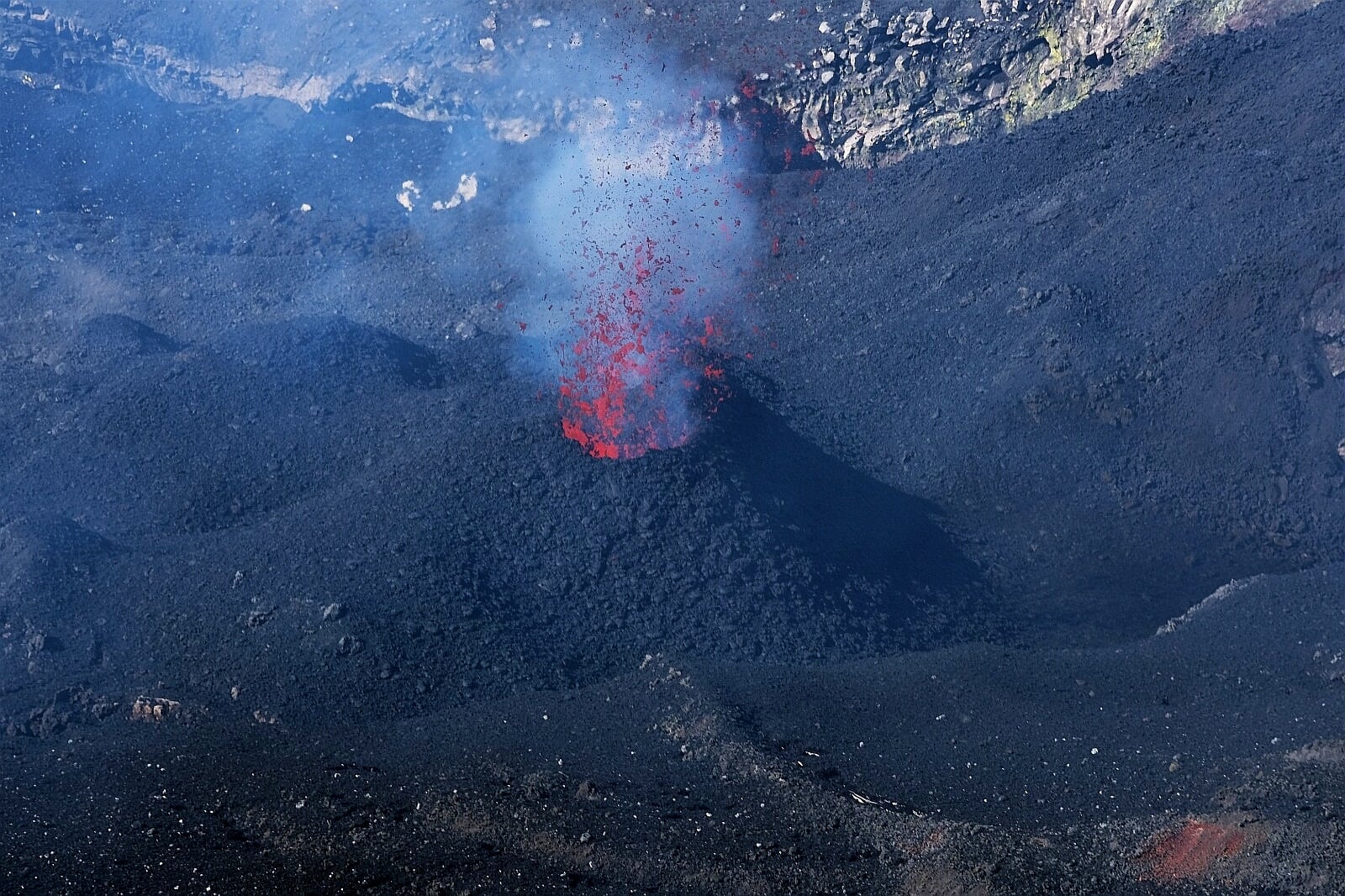
– Concerning the effusive activity, the continuity of growth of the dome is recognized without significant variations in its morphology. Concerning the L5 lava flow, an intense and continuous degassing has been recorded from its frontal zone since January 23, 2021, the development of which continues until the end of the period evaluated. This phenomenon coincides with the identification of a new elevation of the thermal radiation anomaly located on the lava front from Sentinel L2 A satellite images, between January 23 and 25, 2021. From the analysis SkySat, Planet Scope and Sentinel L2 A satellite images in true color, a lava front range of 808 m from the crater rim and a speed of 0.04 m / h is estimated, with further development of its channel central, which has grown by at least 40 m in width in its proximal area.
In turn, according to surveillance cameras, an acceleration in the emission rate is recorded, accompanied by a change in the forward dynamics of the forehead, the morphology of the side « dikes » and the incipient development of side lobes in the proximal area of the crater. The sum of these results is interpreted as a change in the rheology of the L5 lava flow. – By processing the available thermal images, maximum temperatures of 305 ° C were observed during the occurrence of explosions and 244 ° C for the L5 lava flow, currently located on the north slope. An increase in the average temperature observed for the L5 lava flow from January 17, from 90 ° C to 111 ° C, is demonstrated, which is consistent with the evolution of the rheology of the L5 lava flow. , according to the geological history obtained during the second half of the month.
Source : Sernageomin .
Photos : REAV Servicio Nacional de Geología y Minería. Josefauna.
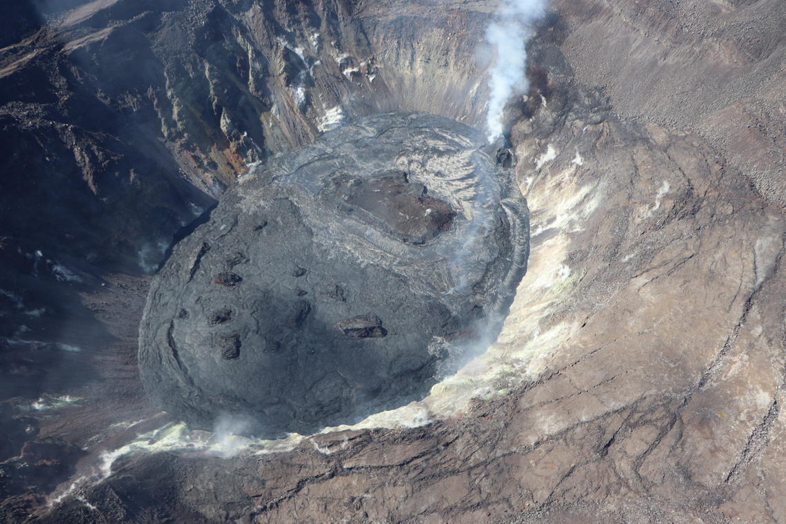
Hawaii , Kilauea :
19°25’16 » N 155°17’13 » W,
Summit Elevation 4091 ft (1247 m)
Current Volcano Alert Level: WATCH
Current Aviation Color Code: ORANGE
Activity Summary:
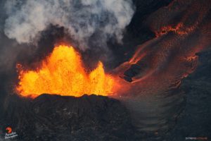
Kīlauea Volcano is erupting. Lava activity is confined to Halemaʻumaʻu with lava erupting from a vent on the northwest side of the crater. As of the morning of February 5, the lava in the western, active portion of the lake in Halemaʻumaʻu was about 211 m (692 ft) deep, with the eastern portion of the lava lake solidified at the surface. SO2 emission rates remain elevated.
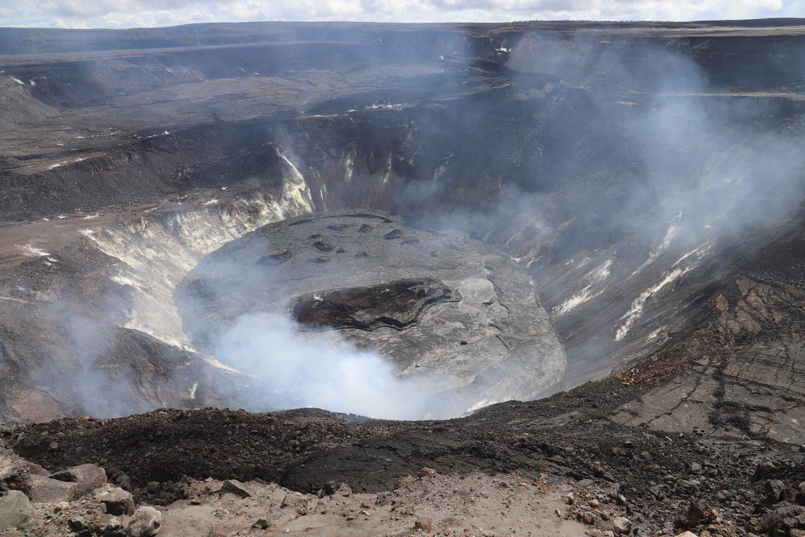
View of the lava lake in Halema‘uma‘u from the western rim of the crater, looking eastward. Volcanic gases emitted from the western fissure obscure the built-up spatter cone. The active western portion of the lake (lower) has a silvery grey color, while the stagnant eastern portion of the lake (upper) is a dark duller grey. The main island is prominent within the active portion of the lake, and the smaller islands are visible in the stagnant portion. The levee on the southern (right) side is also visible.
Summit Observations:
The most recent sulfur dioxide emission rate measurements from February 1 are about 2,200 t/d—lower than the emission rates from the pre-2018 lava lake (3,000–6,500 t/d). The summit tiltmeters show the continuation of deflationary tilt over the past day. Seismicity remains elevated but stable, with elevated tremor and a few minor earthquakes.
Halemaʻumaʻu lava lake Observations:
Lava from the west vent continues to supply Halema‘uma‘u crater with lava. The elevation of the western portion of the lake lake dropped slightly (about 1 meter, or yard) over the past day, likely related in part to a slight decrease in eruption rate that has been observed during previous summit deflation episodes.
An aerial view of Halema‘uma‘u crater from the northeast during a helicopter overflight of the Kīlauea summit eruption on February 1. The dull black color on the eastern (lower left) portion of the lava lake is the inactive surface. The more reflective silver surface is the western (upper right) active portion of the lava lake, with the gas plume marking the location of the west vent. The perched rim is visible along the perimeter of the lake. Many small islands remain in the inactive half of the lake, with only the main island located in the active half of the lava lake.
As of the morning of February 5, lava was about 211 m (692 ft) deep in the active western portion of the lava lake in Halemaʻumaʻu. Eruptive activity continues at the western fissure, supplying lava to the lava lake via a lava stream at the inlet site along the west margin. Yesterday, HVO geologists observed continued supply at the inlet site, and no major changes in the lake. Active surface lava remains largely confined to the western half of the lake, as before. The western portion of the lake continues to have scattered crustal foundering. The stagnant eastern area of the lake was measured yesterday at about 5 m (16 feet) lower than the perched, elevated, and active western portion. A series of surface cracks separates the active from the stagnant part of the lake. The islands remain stationary over the past week.
Source : HVO
Photos : USGS / N. Deligne , UGSS / B. Carr.