June 03 , 2018.
Pu’u ‘Ō’ō / Kilauea , Hawai :
Friday, June 1, 2018, 10:29 PM HST (Saturday, June 2, 2018, 08:29 UTC)
19°25’16 » N 155°17’13 » W,
Summit Elevation 4091 ft (1247 m)
Current Volcano Alert Level: WARNING
Current Aviation Color Code: RED
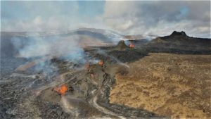
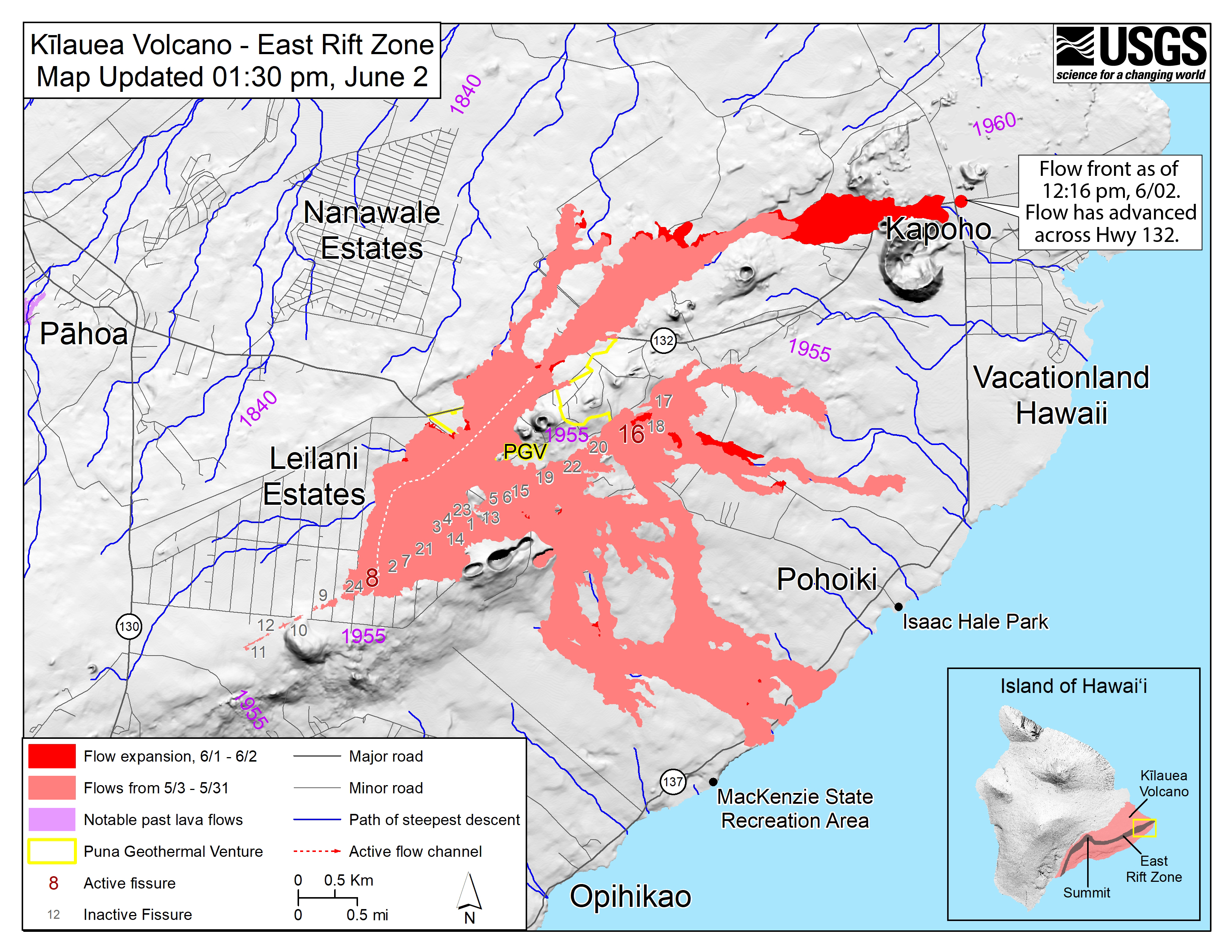
Kīlauea Volcano Lower East Rift Zone
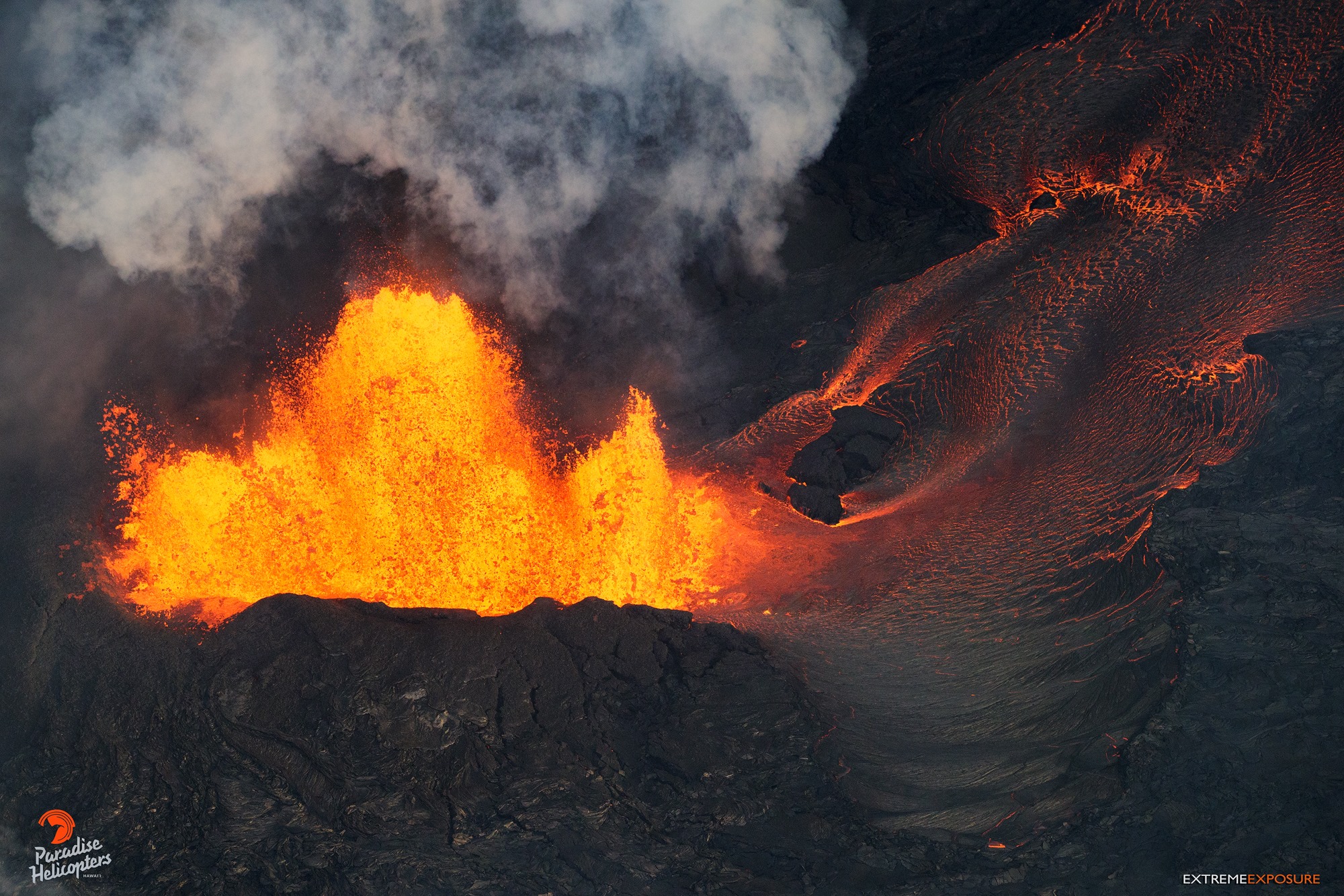
Vigorous eruption of lava continues from the lower East Rift Zone (LERZ) fissure system in the area of Leilani Estates and Lanipuna Gardens.
Fountaining at Fissure 8 is reaching 180 – 220 feet in height and continues to feed a channelized lava flow to the northeast along Highway 132 and down into the Four Corners region (at the intersection of Highways 132 and 137). Small overflows from the channel are occurring along its length, including in a few places near the intersection of Highway 132 and Pohoiki road. As of 9:50 PM HST the flow front was approximately 0.28 miles from the intersection. The more western branches of the Fissure 8 flow either stalled or advanced only short distances.
https://www.facebook.com/ExtremePursuit/videos/507452662983675/
Fissure 18 appears to be crusted over or inactive. The flows that had been moving toward Highway 137 are either inactive or moving very slowly. Fissure 22 appears to be inactive.
Pele’s hair and other lightweight volcanic glass from high fountaining of Fissure 8 are falling downwind of the fissure and accumulating on the ground within Leilani Estates. Winds may waft lighter particles to greater distances. Residents are urged to minimize exposure to these volcanic particles, which can cause skin and eye irritation similar to volcanic ash.
HVO field crews are on site tracking the fountains, lava flows, and spattering from multiple fissures as conditions allow and are reporting information to Hawaii County Civil Defense.
Volcanic gas emissions remain very high from the fissure eruptions. Trade wind conditions are bringing vog to the south and west sides of the Island of Hawaii.
Magma continues to be supplied to the lower East Rift Zone. Earthquake locations have not moved farther downrift in the past few days and the number of located earthquakes remains low.
Seismicity remains relatively low with numerous small magnitude earthquakes and low amplitude background tremor.
Additional ground cracking and outbreaks of lava in the area of the active fissures are possible. Residents downslope of the region of fissures should heed all Hawaii County Civil Defense messages and warnings.
USGS/HVO continues to monitor the lower East Rift Zone activity 24/7 in coordination with Hawaii County Civil Defense.
Kīlauea Volcano Summit
A small explosion occurred form the summit at 1:39 PM HST. Ash emissions are overall decreased, however, possibly reflecting the accumulation of rubble at the base of the growing summit crater. Earthquake activity remains high due to ongoing summit deflation. Additional explosive events that could produce minor amounts of ash fall downwind are possible at any time. Volcanic gas emissions at the summit remain high.
Saturday, June 2, 2018, 9:20 AM HST (Saturday, June 2, 2018, 19:20 UTC)
Kīlauea Volcano Lower East Rift Zone
Vigorous eruption of lava continues from the lower East Rift Zone (LERZ) fissure system in the area of Leilani Estates and Lanipuna Gardens.
Fountaining at Fissure 8 continued unabated overnight, feeding a channelized lava flow to the northeast along Highway 132 and down into the Four Corners region (at the intersection of Highways 132 and 137). As of 6:40 AM HST, the flow front was approximately 100 yards west of the intersection and advancing along a broad front over 300 yards in width extending both north and south of Highway 132. Small overflows from the Fissure 8 channel are common, some of which are occurring near the intersection of Highway 132 and Pohoiki road. Other branches of the Fissure 8 lava flow were inactive.
https://www.facebook.com/kevin.carpenter84/videos/10212545972867861/
The only other lava flow noted by the morning overflight was at Fissure 16, which was weakly active.
Pele’s hair and other lightweight volcanic glass from high fountaining of Fissure 8 are falling downwind of the fissure and accumulating on the ground within Leilani Estates. Winds may waft lighter particles to greater distances. Residents are urged to minimize exposure to these volcanic particles, which can cause skin and eye irritation similar to volcanic ash.
HVO field crews are on site tracking the fountains, lava flows, and spattering from multiple fissures as conditions allow and are reporting information to Hawaii County Civil Defense.
Volcanic gas emissions remain very high from the fissure eruptions. Trade wind conditions are bringing vog to the south and west sides of the Island of Hawaii.
Magma continues to be supplied to the lower East Rift Zone. Earthquake locations have not moved farther downrift in the past few days and the number of located earthquakes remains low. Seismicity remains relatively low with numerous small magnitude earthquakes and low amplitude background tremor.
Additional ground cracking and outbreaks of lava in the area of the active fissures are possible. Residents downslope of the region of fissures should heed all Hawaii County Civil Defense messages and warnings.
USGS/HVO continues to monitor the lower East Rift Zone activity 24/7 in coordination with Hawaii County Civil Defense.
Kīlauea Volcano Summit
Earthquake activity at the summit overnight was calm. Ash emissions are low as revealed by webcam views this morning. Small explosive events, like that of Friday afternoon, could produce minor amounts of ash fall downwind at any time. Volcanic gas emissions at the summit remain high.
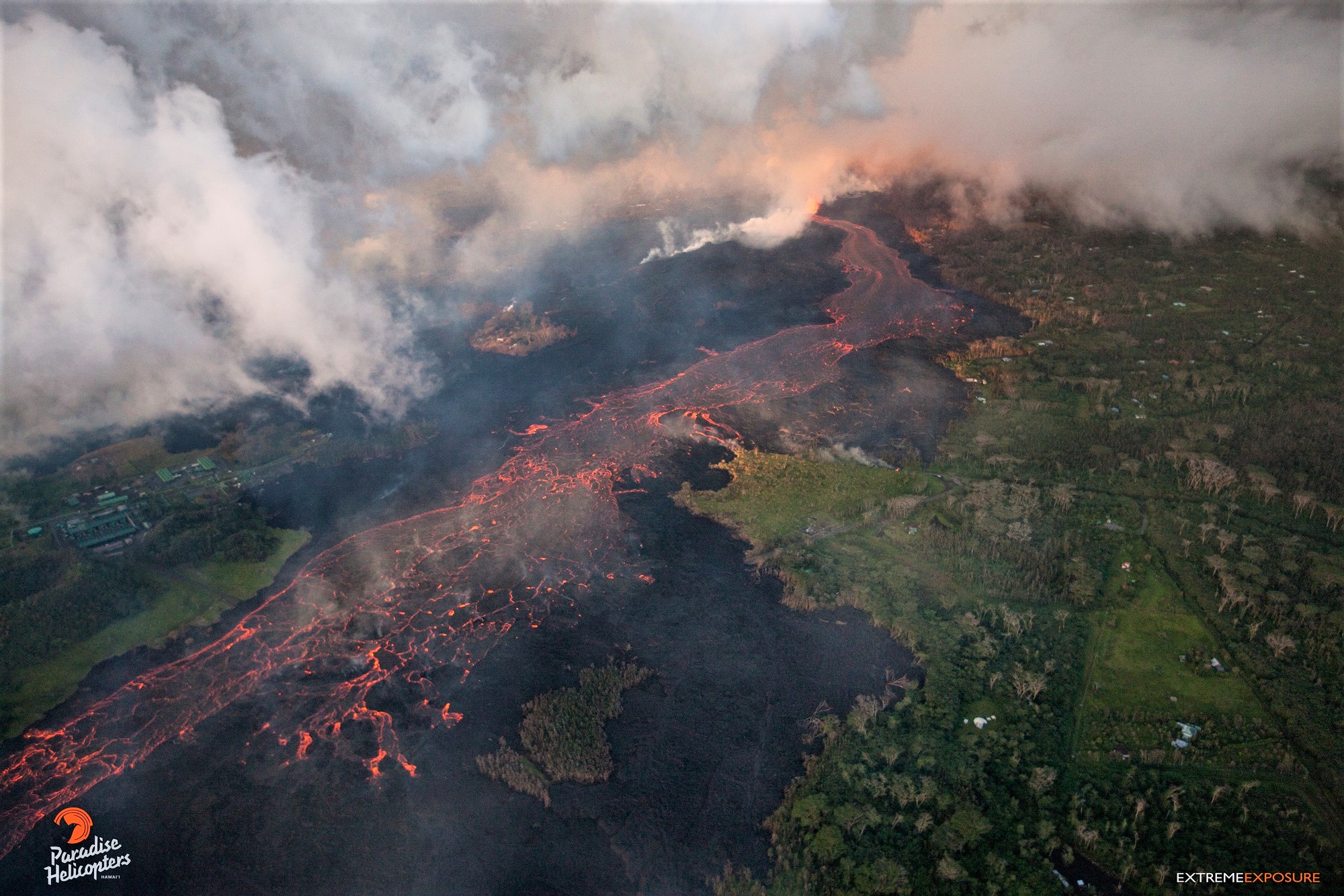
East Rift Zone Eruption: SAT, 06/02/18, 6PM – Update 4
This is a Civil Defense Message for Saturday, June 2 at 6:00 in the evening.
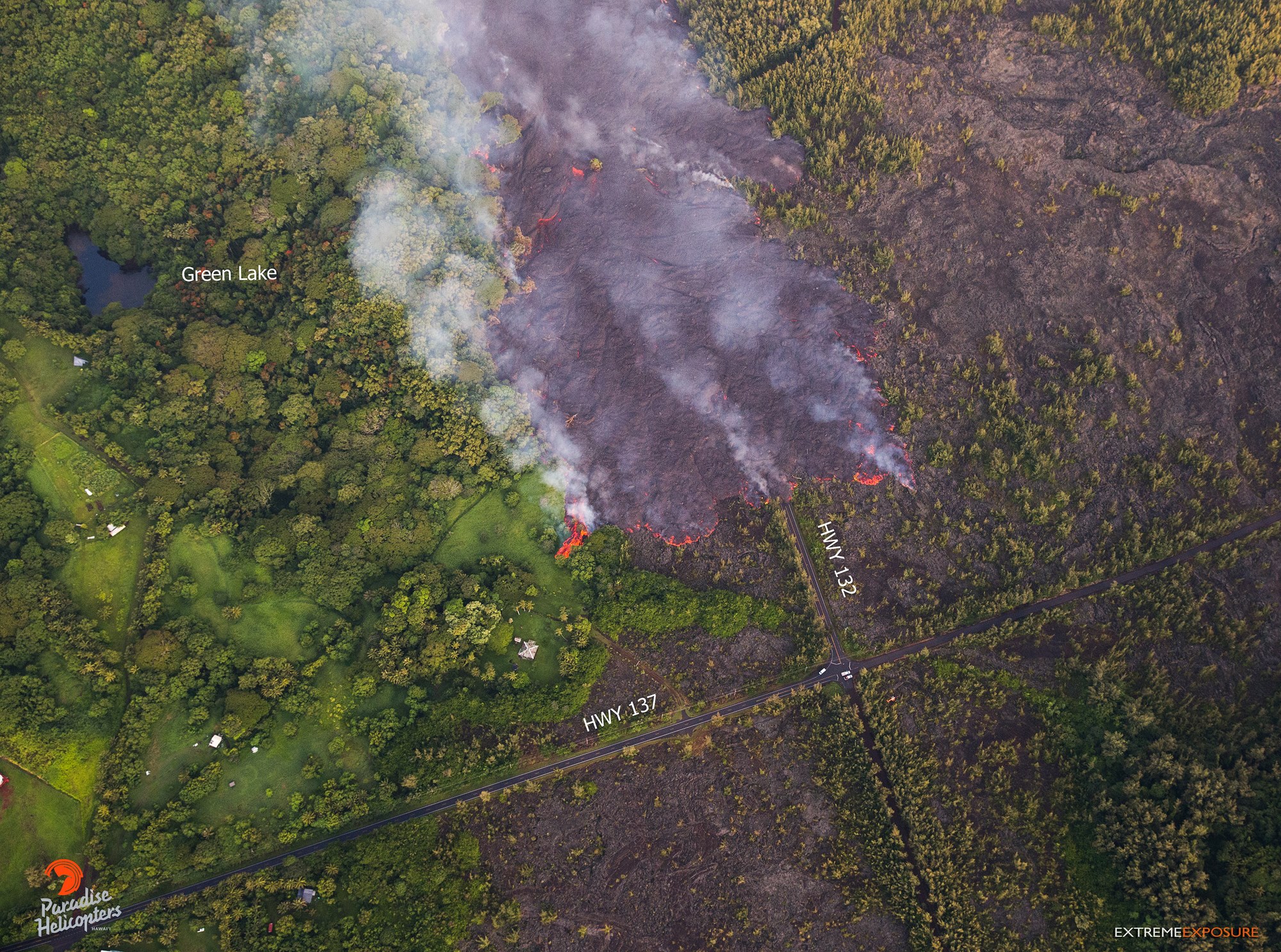
Hawaiian Volcano Observatory reports that vigorous lava eruptions continue throughout the lower East Rift Zone in Leilani Estates and Lanipuna Gardens. Fissure 8 is feeding a large channelized flow traveling along Highway 132, the Pahoa-Kapoho Road.
Lava has crossed Government Beach Road and Highway 137, and inundated the Four Corners intersection. The flow is moving downslope toward the ocean into Kapoho Beach Lots.
The northern flow front is above Four Corners, near the intersection. The southern flow front crossed Highway 137, Kalapana-Kapoho Road, 300 feet south of the Four Corners intersection. Part of the flow hit Green Lake and is creating a steam plume in the area. The flow is moving downslope toward the ocean.
Due to lava crossing Highway 137, the following policies are in effect:
There is no access to Kapoho, Vacationland, Highway 132, and Highway 137.
On roadways:
Government Beach Road, between Kahakai Boulevard and Cinder Road, is open to Waa Waa and Papaya Farms Road residents only with official credentials. There is no curfew.
Volcanic gas emissions remain high at the Kilauea summit and in the fissure system. Residents in communities downwind should take action to limit exposure to gas and ash. On the coast, be aware of laze gas from the ocean entry.
Source : HVO , Civil Défense .
Photos : Bruce Omori.
Carte : USGS.
Vidéos : Extreme Pursuit , Kevin Carpenter.
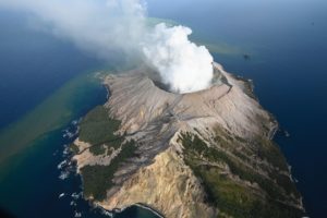
Yellowstone , United – States :
Friday, June 1, 2018, 3:36 PM MDT (Friday, June 1, 2018, 21:36 UTC)
44°25’48 » N 110°40’12 » W,
Summit Elevation 9203 ft (2805 m)
Current Volcano Alert Level: NORMAL
Current Aviation Color Code: GREEN
Recent work and news
May was an exceptional month for the Yellowstone Volcano Observatory (YVO)!
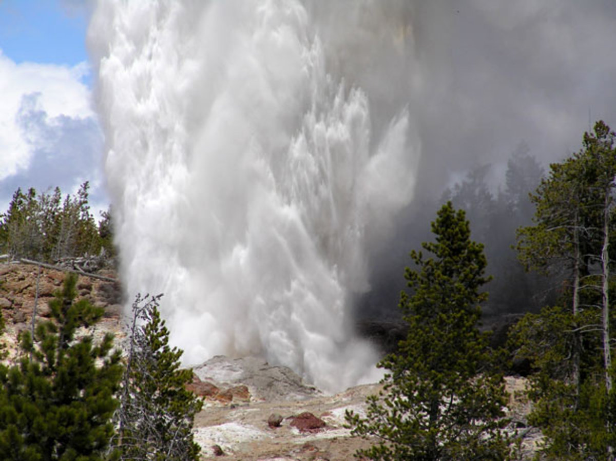
(1) Steamboat Geyser erupted 4 times during the month (May 4, 13, 19, and 27), bringing the total number of eruptions in 2018 to 7. The eruptions display a rough periodicity, occurring every 7-8 days. University of Utah scientists deployed a portable seismic array around the geyser in early May and have captured three eruptions so far. It is hoped that these data will help to map the geyser’s plumbing system, perhaps revealing insights into how intermittent geysers work.

Steamboat geyser in the steam phase of eruption on March 16, 2018. the steam phase usually follows a few- to tens-of-minutes water phase and can last for hours to days. National Park Service photograph by Behnaz Hosseini.
(2) The 2018 YVO coordination meeting was held during May 7-8. Scientists from almost all YVO member institutions presented the results of research and monitoring efforts, developed plans for strengthening communications with each other and the public, and discussed the priorities for future research. It was agreed that thermal areas, which represent the boundary between deep Earth processes and surface biology, are the most important areas requiring additional study, and YVO is hoping to develop a coordinated research plan to address the topic soon. In addition to the scientific meeting, a public event was held in Gardiner, Montana, on May 7, when over 70 people had the chance to have their Yellowstone questions answered and to interact with YVO scientists.
(3) Field season is upon us! Several YVO scientists took advantage of the coordination meeting to conduct field operations. This included geologic studies and the maintenance of continuous monitoring equipment. Of special note was the deployment of 12 semi-permanent GPS stations around the Park, which will record data on site (without a radio link) and be retrieved in October. These data fill some « gaps » between continuous GPS stations and will help researchers better understand the characteristics and causes of ground motion in the region.
Seismicity
During May 2018, the University of Utah Seismograph Stations, responsible for the operation and analysis of the Yellowstone Seismic Network, located 123 earthquakes in the Yellowstone National Park region. The largest event was a minor earthquake of magnitude 3.1 that occurred about nine miles northeast of West Yellowstone, MT, on May 6 at 8:54 AM MDT. No earthquakes were reported « felt » in the Yellowstone region in May.
Activity continued in the area of last summer’s Maple Creek swarm, with 70 May earthquakes. This persistent seismicity includes the largest event of the month (the aforementioned magnitude 3.1 earthquake on May 6).
Earthquake sequences like these are common and account for roughly 50% of the total seismicity in the Yellowstone region.
Yellowstone earthquake activity remains at background levels.
Ground deformation
Subsidence of all parts of Yellowstone caldera continued throughout May at rates of a few centimeters per year — a pattern that has been ongoing since 2015. Uplift rates in the area of Norris Geyser Basin, measured by station NRWY, have similarly been on the order of a few centimeters per year.
The Yellowstone Volcano Observatory (YVO) provides long-term monitoring of volcanic and earthquake activity in the Yellowstone National Park region. Yellowstone is the site of the largest and most diverse collection of natural thermal features in the world and the first National Park. YVO is one of the five USGS Volcano Observatories that monitor volcanoes within the United States for science and public safety.
Source : USGS
Photos : USGS
San Miguel ( Chaparrastique ) El Salvador :
Special Report No 12
The changes in activity of the Chaparrastic volcano persist. Date and time of publication: 2018-06-01 14:30:00
As of Tuesday, May 22, there has been a significant increase in the number of earthquakes on the volcano (Figure 1), with predominantly low and high frequency earthquakes, with depths less than 1.5 km deep, located in the crater area. None of them was perceived by the population. Due to their spectral characteristics, they are related to sudden and periodic changes in fluid pressure inside the volcano. This situation indicates the probability that in the future there will be an event with gas and ash emissions as during previous crises, or, with less probability, the presence of lava in the crater area.
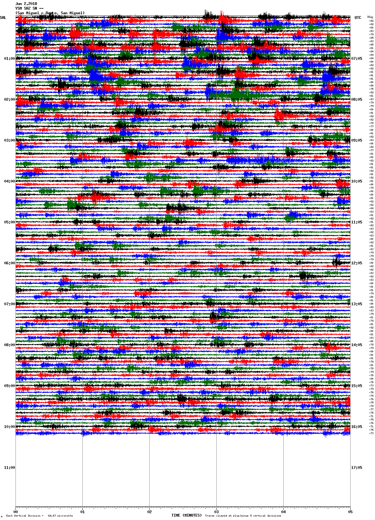
Fig. 1. Seismogram of the Chaparrastique volcano on June 2, 2018.
In the last 24 hours, the values of the seismic vibration of the volcano have fluctuated between 142 and 176 RSAM units, with an average time of 142 units, when the acceptable threshold is 150 units.
The earthquakes of the volcano show a predominance of low and high frequency earthquakes. None of them are perceived by the population.
The spectra show low frequency bands, related to the increase in the number of earthquakes from day 22, indicating a change of pressure by the movement of fluids inside the volcano.
MARN continues the systematic monitoring of the volcano and maintains close communication with the Directorate General of Civil Protection and local observers. In addition, he calls tourists and mountaineers to stay away from the top of the volcano due to sudden changes in his behavior.
The next report will be published on Friday, June 8th. In the event of a significant change, another special report will be published.
Source : Marn
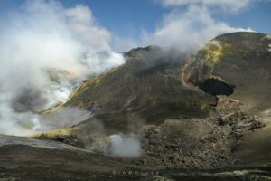
Merapi , Indonesia :
Level II Activity Level (WASPADA).
Since yesterday until this morning, visually the volcano can be observed clearly until the appearance of fog. Crater smoke is observed as white, low pressure and low to high intensity with an altitude of 800 m above the peak. The wind is weak to moderate in the southwest and northwest.
According to the seismographs, on June 2, 2018, it was recorded:
7 earthquakes of falling rocks.
5 hybrid earthquakes
14 earthquakes of emission
3 distant tectonic earthquakes.
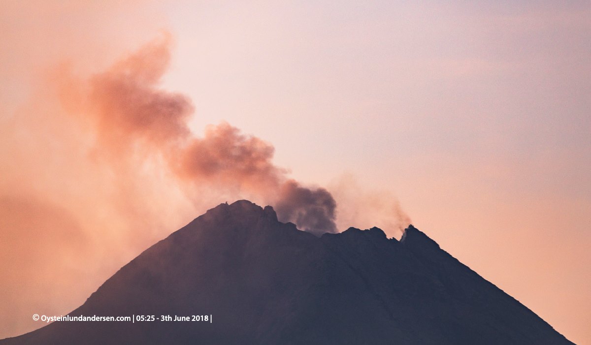
Small ashfall reported North of Merapi earlier today, approx. 30min after this photo was taken.
Recommendations:
Climbing activities are temporarily not recommended, except for the benefit of investigation and research related to disaster mitigation efforts.
A radius 3 km around the summit is forbidden to the population.
People living around the volcano must be made aware of the activities of G. Merapi.
If there are significant changes in Merapi activity, the Merapi Activity Alert will be revised.
VONA:
The last code Vona sent was a color code ORANGE, published on June 1, 2018 at 21:07 pm, related to the eruption with the altitude of the ash column about 3968 m above sea level , about 1000 m above the summit. The column of ashes was heading northwest.
Source : VSI
Photo : Øystein Lund Andersen