September 05 , 2020.
Russia / Kurile Islands , Ebeko :
VOLCANO OBSERVATORY NOTICE FOR AVIATION (VONA).
Issued: September 05 , 2020 .
Volcano: Ebeko (CAVW #290380)
Current aviation colour code: ORANGE
Previous aviation colour code: orange
Source: KVERT
Notice Number: 2020-178
Volcano Location: N 50 deg 41 min E 156 deg 0 min
Area: Northern Kuriles, Russia
Summit Elevation: 3791.68 ft (1156 m)
Volcanic Activity Summary:
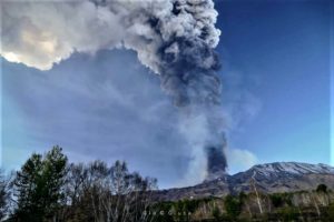
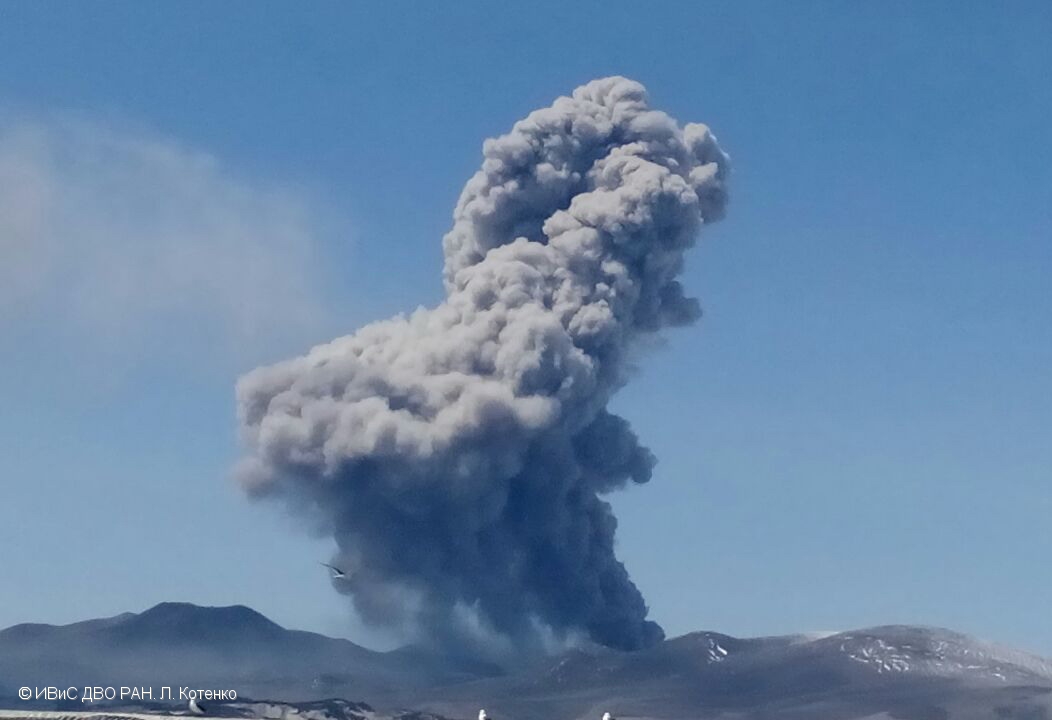
A moderate eruptive activity of the volcano continues. According to visual data by volcanologists from Severo-Kurilsk, explosions sent ash up to 3.5 km a.s.l., an ash cloud is drifting to the south-east of the volcano.
This activity of the volcano continues. Ash explosions up to 19,700 ft (6 km) a.s.l. could occur at any time. Ongoing activity could affect low-flying aircraft and airport of Severo-Kurilsk.
Volcanic cloud height: 9840-11480 ft (3000-3500 m) AMSL Time and method of ash plume/cloud height determination: 20200905/0434Z – Visual data
Other volcanic cloud information: Distance of ash plume/cloud of the volcano: 2 mi (3 km)
Direction of drift of ash plume/cloud of the volcano: SE
Time and method of ash plume/cloud determination: 20200905/0434Z – Visual data.
Source : Kvert.
Photo : L. Kotenko, IVS FEB RAS .
Indonesia , Sinabung :
VOLCANO OBSERVATORY NOTICE FOR AVIATION – VONA.
Issued : September 04 , 2020 .
Volcano : Sinabung (261080)
Current Aviation Colour Code : ORANGE
Previous Aviation Colour Code : orange
Source : Sinabung Volcano Observatory
Notice Number : 2020SIN25
Volcano Location : N 03 deg 10 min 12 sec E 98 deg 23 min 31 sec
Area : North Sumatra, Indonesia
Summit Elevation : 7872 FT (2460 M)
Volcanic Activity Summary :
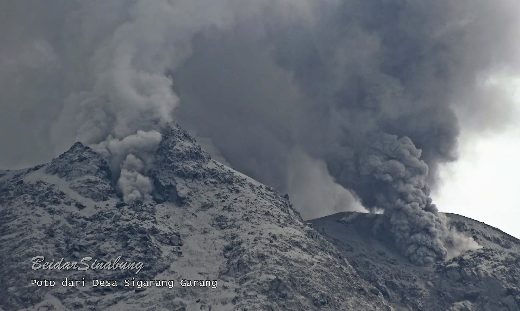
Eruption with volcanic ash cloud at 22h13 UTC (05h13 local). Eruption and ash emission is continuing.
Volcanic Cloud Height :
Best estimate of ash-cloud top is around 10432 FT (3260 M) above sea level, may be higher than what can be observed clearly. Source of height data: ground observer.
Other Volcanic Cloud Information :
Ash-cloud moving to north-northeast
Remarks :
Seismic activity is characterized by continuous volcanic tremor
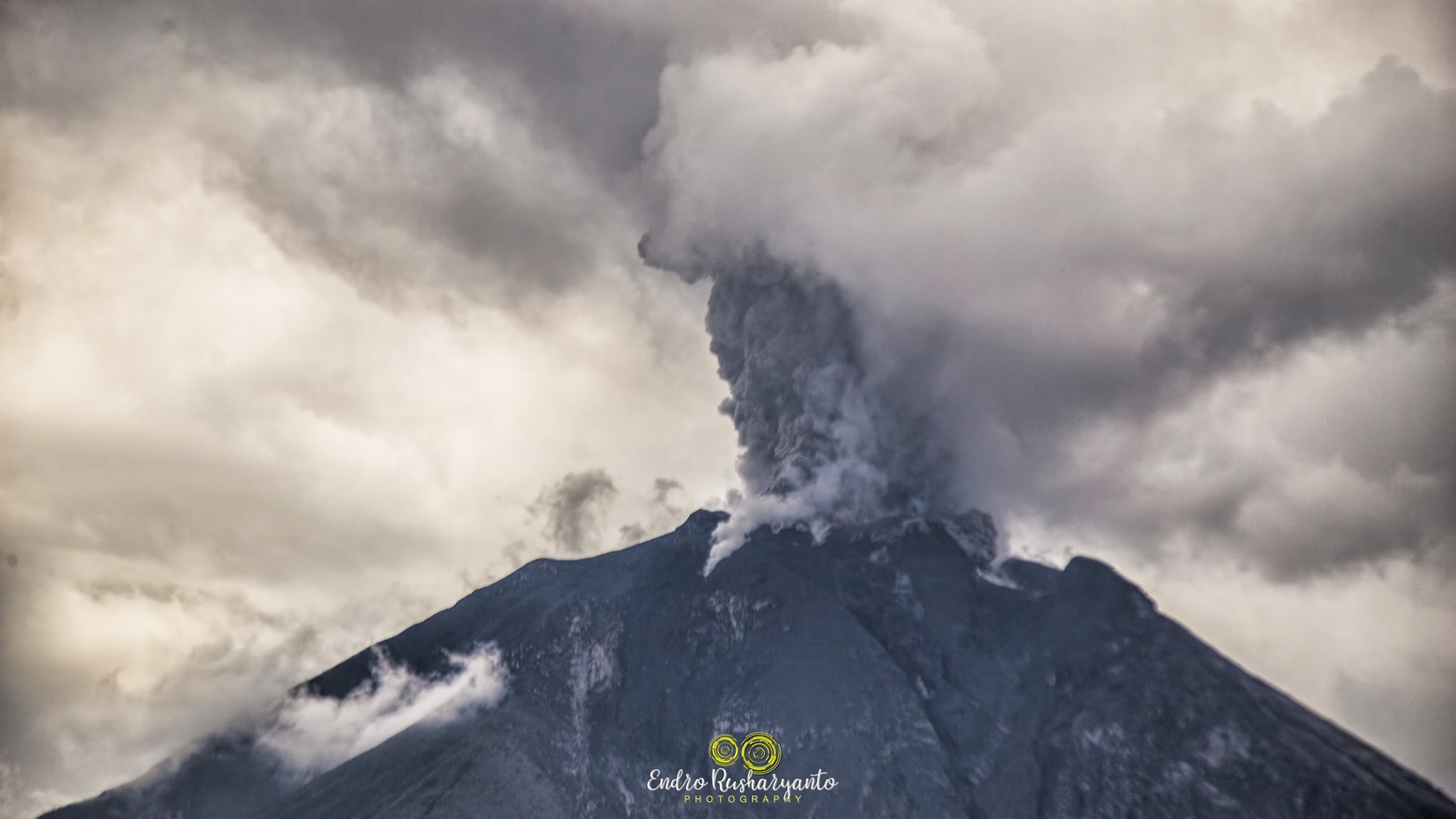
The activity level has been at level III (SIAGA) since May 20, 2019 at 10:00 a.m. Mount Sinabung (2460 m above sea level) has been erupting since 2013. The last eruption occurred on September 5, 2020 with the height of the eruption column at 800 meters above the summit.
The volcano was clearly visible until it was covered in fog. The crater emits thick white smoke, with a moderate height of around 100 meters above the summit. The weather is cloudy, rain, light winds to the South-West, West and North-West.
According to the seismographs of September 4, 2020, it was recorded:
5 emission earthquakes
3 low frequency earthquakes
2 hybrid earthquake
1 deep volcanic earthquake
2 local tectonic earthquakes
4 distant tectonic earthquakes
Recommendation:
Communities and visitors / tourists should not conduct activities in villages that have been displaced, as well as within a radial radius of 3 km around the summit of Mount Sinabung, and within a sector radius of 5 km for the southern sector -East and 4 km for the East-North sector.
Source :Magma Indonésie , PVMBG.
Photo : Beidar Sinabung , Endro Rusharyanto via Sadrah Peranginangin .
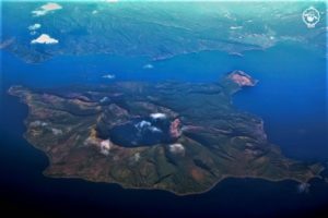
Ecuador , Sangay / Cotopaxi / Cayambe :
SURVEILLANCE REPORT OF OVERFLIGHTS OF SANGAY, COTOPAXI AND CAYAMBE VOLCANOES
As part of the volcanic monitoring work that the Geophysical Institute of the National Polytechnic performs periodically, an overview of the Sangay, Cayambe and Cotopaxi volcanoes was carried out between August 18 and 19, 2020. For this, they had the logistical support of the aircraft CESSNA-206 of the company Alas de Socorro del Ecuador (ADSE), according to the route shown in Fig. 1, from Shell (Province of Pastaza).
The objectives proposed to assess the surface activity and morphological changes of these volcanoes were related to taking photographs, infrared (IR) images and measuring volcanic gases. The temperature values considered here are expressed in maximum apparent temperature (TMA), which corresponds to the incident radiation in the thermal camera.
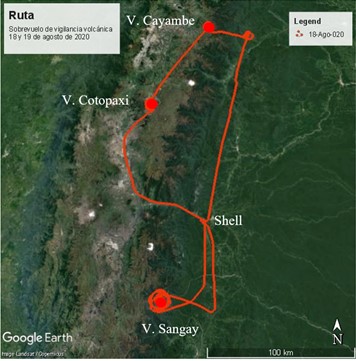
Figure 1. Map with the route of the surveillance flight carried out on August 18 and 19, 2020 (Google Earth Base).
Sangay volcano:
Climatic conditions in the Sangay volcano sector were regular. Almost all of the volcano was cloudy except for a part of the summit and the south-eastern flank, which currently shelters a ravine formed since the previous year as a result of a continuous erosive process (Fig. 2) . This area is easily recognizable from the summit to the base of the volcano when weather conditions permit.
Thanks to the analysis of infrared images, it was possible to determine the presence of an active lava flow, emitted very close to the summit and descending through the ravine, the width of which could be calculated at about 435 m (Fig. 2). It was estimated that the TMA of the lava flow reached 396 ° C and was 80 and 580 m wide and long, respectively. This recent lava flow was observed to be localized on previous lava flows. Below the front of this active lava flow, the presence of hot volcanic material (TMA <100 ° C) has been identified, which could be associated with the continued collapses of the lava flow fronts that cause the formation of pyroclastic flows. which are regularly channeled into this ravine.

Figure 2. Left: Photograph of the southeast flank of Sangay volcano, showing the infrared analysis zone in a red rectangle. Right: Composite image of several infrared images showing part of the ravine on the south-eastern flank and an active lava flow that descended inside and did not reach a length greater than about 580 m. Photography and IR image: S. Vallejo Vargas, IG EPN, 2020 08 18.
In addition, during the overflight, continuous gas emissions and at least two explosions with medium ash content were observed in a westerly direction.
Cotopaxi volcano:
So far in 2020, the activity recorded on the Cotopaxi volcano has been characterized by sporadic emissions of volcanic gases from the crater of the volcano. None of the monitoring parameters (seismicity, deformation, volcanic gases (SO2)) showed an anomaly over a period of time.
During the aerial surveillance carried out on the volcano on August 19, despite the intense cloudiness around the volcanic building, the summit was perfectly clear. Under these conditions, weak but continuous emissions of volcanic gases from the internal crater were identified (Fig. 3).

Figure 3. South-South-East view of the crater of the Cotopaxi volcano where the so-called ring of sand is observed, as well as a slight emission of volcanic steam and gases from the internal crater. Photograph: F. Naranjo, IG EPN, 2020 08 18.
Regarding the temperatures recorded by infrared monitoring, the analysis performed, which is shown in Fig. 4, did not show temperature values outside the normal ranges. For the northern flank, in the area known as Yanasacha, an average TMA of 27.3 ° C was estimated. For the areas surrounding the central crater, with reference to what is called the sand ring, the areas of thermal anomalies showed similar temperatures, TMA = 27.3 ° C. The area which concerns the eastern sector had a TMA of 33.4 ° C, while for the South and West zones, 18.9 ° C and 10.4 ° C respectively. On the other hand, the measurements taken on the walls of the duct in the inner crater reached a TMA = 18.1 ° C, similar to the low temperatures obtained in December 2019.
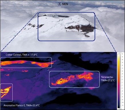
Figure 4. Photograph (top) and IR image (bottom) of the view from the northeast of the volcano, where we can see the Yanasacha sectors (on the northern flank), the eastern anomalies and of the background. south-west of the central crater with their respective TMA values. Photography and IR image: F. Naranjo / S. Vallejo Vargas, IG EPN, 2020 08 18.
Cayambe volcano:
So far in 2020, the activity recorded on the Cayambe volcano has not shown any variations in any of the monitoring parameters (seismicity, deformation, volcanic gases (SO2)). During monitoring, the volcano was partly cloudy, however, the summit was clear (Fig. 5).
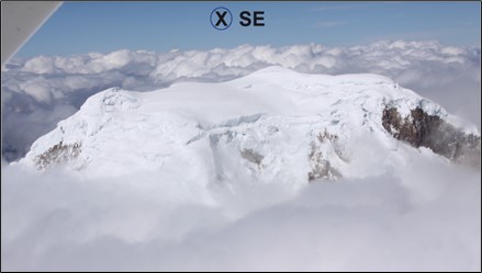
Figure 5. View of the summit from the south-eastern sector during the surveillance overflight of 08/19/2020. Photograph: F. Naranjo, IG EPN, 2020 08 18.
According to infrared monitoring, no abnormal temperature value was detected on the volcano. However, there are areas where the rocks, due to their steep slopes and the effects of solar radiation, do not allow the accumulation of snow or glaciers, and their measurements did not exceed a TMA of 21.5 ° C ( Fig. 6). These values are similar to those measured in previous observations.

Figure 6. Photograph (top) and IR image (bottom) of the view of the South-South-East sector (SSE) of the Cayambe volcano, where sectors with rocks without ice cover are identified, influenced by solar radiation. Photography / IR Image: F. Naranjo / S. Vallejo, IG EPN, 2020 08 18.
General conclusions
The Sangay volcano continues to exhibit significant surface activity, which is characterized by the generation of lava flows (TMA ~ 396 ° C) emitted near the summit and descending along the south-eastern flank while being channeled by the ravine. present on this flank. The collapse of the fronts of the lava flows generates the accumulation of volcanic matter along the mentioned ravine. In addition, the presence of continuous gas emissions and sporadic low ash explosions were observed, as observed during the visit. During the overflight, the generation of pyroclastic flows was not observed.
The Cotopaxi volcano does not present representative changes for the different sectors with thermally anomalous zones around the summit of the volcano (inside the crater and its sides).
The Cayambe volcano shows no change from the temperatures observed around its summit.
Source : FN, SV, PR, DA, BB , Institut géophysique / Ecole polytechnique nationale.
Iceland , Reykjanes Peninsula :
Yesterday at 12:39 pm an earthquake of M3.1 was detected in the northeastern part of the Katla caldera, near Austmannsbunga. Few minutes before another earthquake of M2.7 was detected within the same area. Few smaller aftershocks followed but no signs of volcanic tremor.
Wednesday evening (2.9.20) at 22:53 a M3.0 occurred just west of Kleifarvatn in the Reykjanes peninsula. The earthquake was felt in the capital area.

Around 2900 earthquakes were detected by the IMO¿s SIL seismic network this week and around 1250 of them have been manually located. This is a lot more activity than last week when around 1300 earthquakes were located. The activity in the North continues and around 500 earthquakes were located there this week. The activity on Reykjanesskagi also continues and around 2100 earthquakes were located there this week. The largest earthquake of the week a M4.2 on August 26th at 16:15 near Fagradalsfjalli and was felt in large parts of the SW corner of Iceland. Two earthquakes where detected in Grímsvatn this week and all was quiet near Hekla.
Source : Vedur is .