
April 20 , 2020.
Italy , Champs Phlégréens :
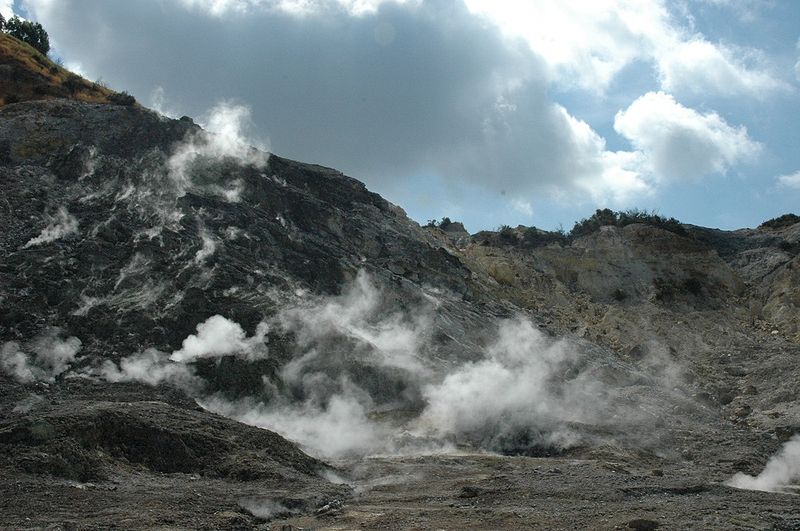
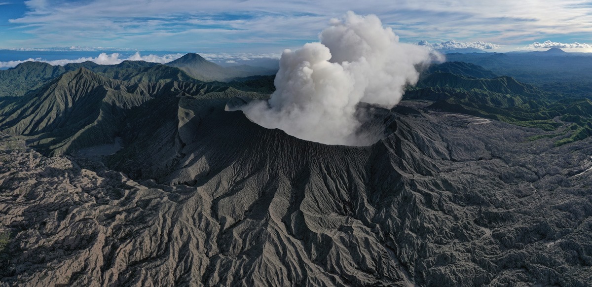
Campi Flegrei, Solfatara – Pisciarelli region. Fake video on the web. No new crater.
by the editorial staff of INGVvulcani
Regarding a video circulating on the net which reports alarming news concerning a « crater » which would have formed « during the Easter holidays » in the Campi Flegrei region, the following is declared:
– the « crater » to which the video refers is the Pisciarelli smoking area;
– the so-called « crater » was not formed during the Easter holidays, but has been active for more than 10 years;
– the INGV « Vesuvian Observatory » section makes continuous measurements (24 hours a day) in the area thanks to the use of geochemical stations which measure: the temperature of the fumarole, the CO2 flow and the CO2 concentration measured in air.
In addition, with the use of seismic stations, the fumarolic tremor is also monitored (24 hours a day);
– the INGV « Vesuvian Observatory » section carries out inspections and sampling at least once a week in the Pisciarelli area;
– the evolution of the process of intensification of hydrothermal activity in the region of Pisciarelli is well known and constantly described in scientific articles and in Bulletins published weekly and monthly and available on the link: http: // www .ov.ingv.it / ov / it / bollettini.html
– the Pisciarelli area has been closed to the public for security reasons since November 2018 (ordinance n ° 190 dated 30.11.2018 by the mayor of Pozzuoli).
Consequently, the content of the video apparently made in violation of the aforementioned union ordinance, the existing orders for the containment of Covid-19 (ordinances of the President of the Campania region and of the Presidency of the Council of Ministers) are denied and also contain elements of possible triggering of alarms which will be rapidly reported to the competent authorities.
During this COVID-19 emergency period, the INGV guarantees the full operation of its seismic, volcanic and tsunami warning rooms in Rome, Naples and Catania and the availability of emergency groups, in complete safety for all those work there
Source : INGV Vulcani .
Photo : , Manuel Mauer / Wikipédia
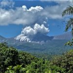
Italy , Stromboli :
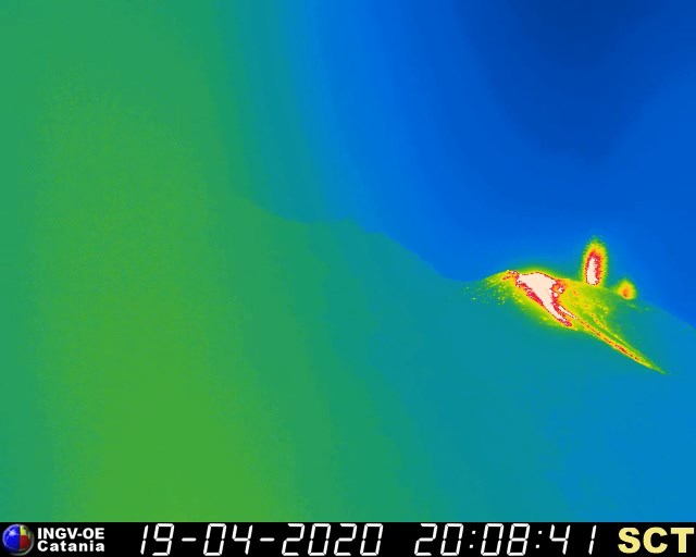
PRESS RELEASE ON VOLCANIC ACTIVITY from 19 April 2020, 20:39:20 H UTC (22:39:20 H LOCAL HOURS) – STROMBOLI.
The National Institute of Geophysics and Volcanology, Etnean Observatory, communicates that from approximately 19:52 h UTC, the surveillance cameras observe a modest lava overflow of the North zone of the crater terrace of Stromboli, which is – currently – confined to the summit area. From the overflow front stands out hot blocks that roll along the Sciara del Fuoco. Ordinary Strombolian activity persists in both areas of the North and South Center craters.
The characteristics of the seismic signal do not show any significant change compared to the previous period. The magnitude of the tremor, the frequency and intensity of the explosions are stationary.
The deformation and GPS stations of Stromboli do not reveal significant variations.
WEEKLY ACTIVITY BULLETIN OF THE VOLCANO STROMBOLI. (April 10 to April 16, 2020).
The activity was characterized by a very strong explosive phase with Strombolian explosions rich in pyroclastic material located mainly in the area of the North craters and by continuous degassing in the area of the Center South craters. This activity is associated with a high number of seismic events of the VLP type which remain confined in the most superficial part of the duct and with acoustic pressures with constantly very high values (max 4.3 bar). The flows of SO2 and CO2 during the past week have remained stable at a BAS value and associated with very low C / S values typical of the pre-effusive phases.
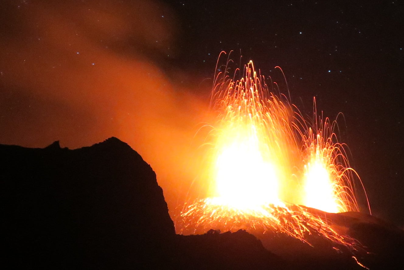
Thermal anomalies by satellite (MODIS) generally reveal moderate values (max 73 MW) in agreement with the high explosive activity associated with a low effusive activity. The general table described by the monitored parameters conforms to a superficial magmatic column very rich in overpressure gas.
On April 14 at 04:12 UTC, soil deflation at the OHO tiltmeter was recorded at 0.38 micro-radiant heaters of approximately 30 minutes. The signal characteristics and the lack of evidence from thermal and visible cameras suggested that an intra-crater overflow with small volumes of magma involved, as described in the extraordinary statement sent.
On April 15 at 07:22 UTC, the cameras showed the occurrence of a lava overflow which generated rolling events associated with a very large seismic signal of about 20 minutes, responsible for a rapid increase in the tremor seismic. Satellite images indicate that the lava overflow was weakly fed by effusive rates of 0.2-0.3 m3 / s, as described in the extraordinary press releases sent. At this moment, the overflow phase seems to have ended.
The global analysis of the geophysical and geochemical parameters highlights during the week a constant level of volcanic activity on high values.
Source : INGV Vulcani .
Photos : INGV , Andrei Nikiforov.
Costa Rica , Rincon de la Vieja :
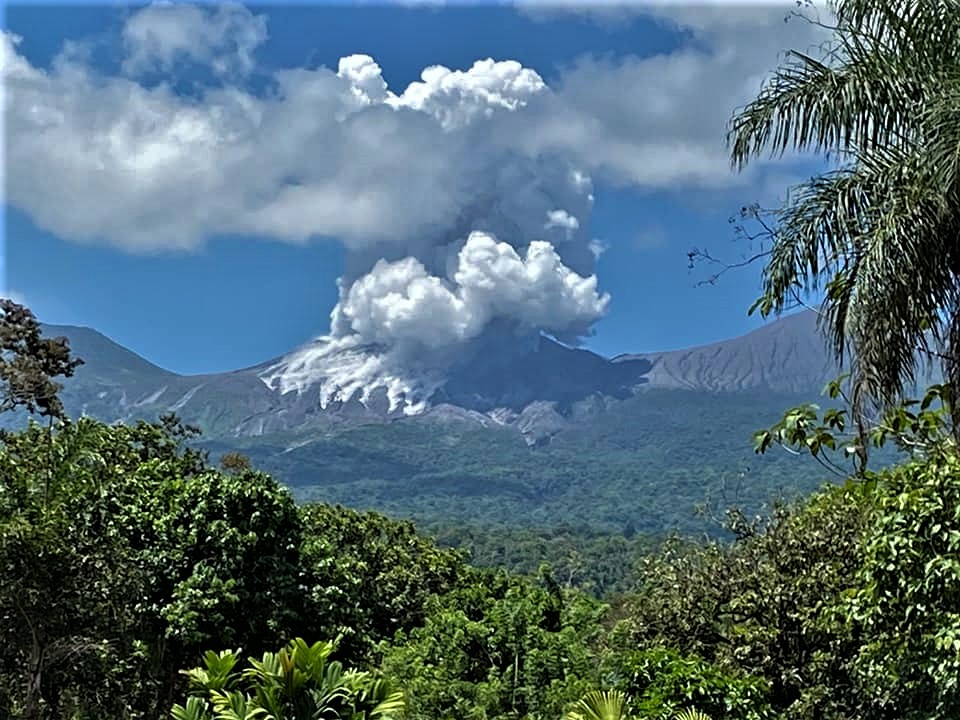
At 10:14 a.m. local time on April 19, 2020, an eruption was recorded on the Rincon de la Vieja volcano, with a column that rose 1,500 meters above the height of the crater and 3,416 meters above sea level. – above sea level (11,204.48 ft).
Duration of activity: less than a minute.
Seismic activity is more important than that of yesterday.
The wind direction is unknown at this time.
In the past few hours, several small eruptions have been observed which did not extend beyond the edge of the crater (for example at 5.30 a.m.). However, at 10:14 a.m., the ejected volcanic material (solid / liquid) reached a height of about 300 m above the crater, generating a plume of vapor (gas) which rose about 1,500 m. .
This eruption produced a lahar. There are still no reports of damage in cities near the volcano.
Source : Ovsicori .
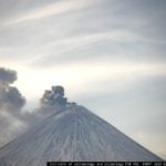
Indonesia , Dukono :
Level of activity at level II (WASPADA). Mount Dukono (1229 m above sea level) is experiencing a continuous eruption. The last eruption occurred on March 26, 2020 with an eruption column height of 400 meters above the summit.
The volcano is covered with fog. No smoke from the crater is observed. The weather is sunny to cloudy, the winds are light to moderate to the North and the Northeast.
According to the seismographs of April 19, 2020, it was recorded:
1 eruption / explosion earthquakes.
2 distant tectonic earthquakes
Continuous tremor (Microtremor) with a maximum amplitude of 0.5 to 4 mm (dominant value 2 mm)
Recommendation:
The communities around G. Dukono and visitors / tourists must not move, climb and approach the crater of Malupang Warirang within a radius of 2 km.
Since volcanic ash eruptions occur periodically and the ash dispersion follows the wind direction and speed, so the ash is not fixed, it is recommended that the community around G. Dukono always have masks / nose and mouth cover to be used when necessary to avoid threats of the danger of volcanic ash in the respiratory system.
VOLCANO OBSERVATORY NOTICE FOR AVIATION – VONA.
Issued: April 19 , 2020
Volcano: Dukono (268010)
Current Aviation Colour Code: ORANGE
Previous Aviation Colour Code: orange
Source: Dukono Volcano Observatory
Notice Number: 2020DUK26
Volcano Location: N 01 deg 41 min 35 sec E 127 deg 53 min 38 sec
Area: North Maluku, Indonesia
Summit Elevation: 3933 FT (1229 M)
Volcanic Activity Summary:
Eruption with volcanic ash cloud at 23h41 UTC (08h41 local).
Volcanic Cloud Height:
Best estimate of ash-cloud top is around 5533 FT (1729 M) above sea level, may be higher than what can be observed clearly. Source of height data: ground observer.
Other Volcanic Cloud Information:
Ash-cloud moving to southeast
Remarks:
Eruption and ash emission is continuing.
Source : PVMBG. Magma Indonésie .
Photo : Martin Rietze


No comment yet, add your voice below!