August 18 , 2018.
Indonesia , Anak Krakatau :
VOLCANO OBSERVATORY NOTICE FOR AVIATION – VONA.
Issued: August 17 , 2018 .
Volcano: Anak Krakatau (262000)
Current Aviation Colour Code: ORANGE
Previous Aviation Colour Code: orange
Source: Anak Krakatau Volcano Observatory
Notice Number: 2018KRA30
Volcano Location: S 06 deg 06 min 07 sec E 105 deg 25 min 23 sec
Area: Lampung, Indonesia
Summit Elevation: 976 FT (305 M)
https://www.facebook.com/Oystein.Lund.Andersen/videos/10161130178275389/
Volcanic Activity Summary:
Eruption with ash clouds at 11:30 UTC (18:30 local time). The eruption lasted for 59 seconds. Eruption and ash emission is continuing.
Volcanic Cloud Height:
Best estimate of ash-cloud top is around 2576 FT (805 M) above sea level, may be higher than what can be observed clearly. Source of height data: ground observer.
Other Volcanic Cloud Information:
Ash-cloud moving to north.
Remarks:
Eruption recorded on seismogram with maximum amplitude 41 mm and maximum duration 59 second.
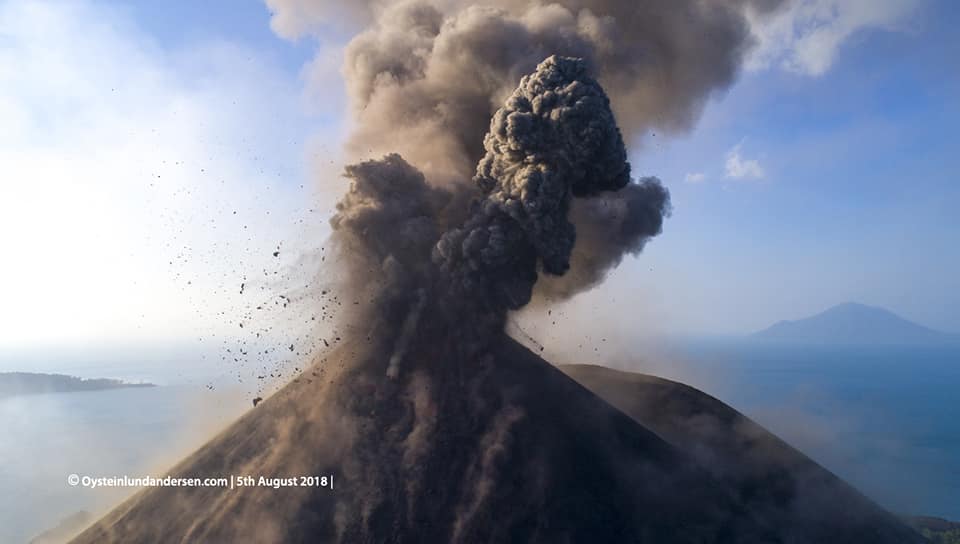
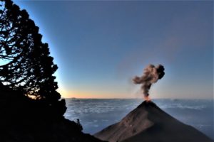
Information on the eruption of Anak Krakatau
August 17, 2018
An eruption of Mount Anak Krakatau, Lampung, occurred on August 17, 2018 at 18:30 with a height of ash column observed at ± 500 m above the summit (± 805 m above sea level). The column of ash observed is black with a thick intensity inclined towards the north. This eruption is recorded on seismograms with a maximum amplitude of 41 mm and a duration of ± 59 seconds.
Currently, the Anak Krakatau is at status level II (Waspada) with a recommendation: people / tourists are not allowed to approach the crater within a radius of 2 km around the crater.
Source : Magma Indonésie , PVMBG
Photo et Vidéo : Oystein Lund Andersen.
Nicaragua , Telica :
The Telica volcano ejected a column of gas 200 meters high.
The Telica volcano, in the department of León, ejected a column of gas and ash 200 meters high, this August 15th. No affected person has been reported.
The authorities maintain permanent surveillance of the volcano to prevent any eventuality.
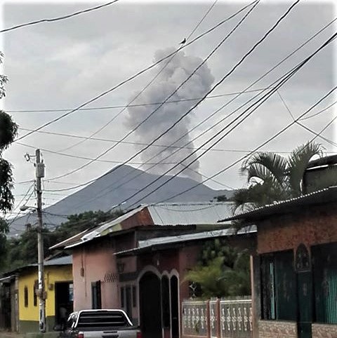
The Telica volcano is an active volcano 30 kilometers from León. The last violent eruption took place in 1948, but since then, the volcano has been expelling smoke with roars.
The height of the volcano is just over one kilometer (1,061 meters), it has a large crater 120 meters deep and 700 in diameter.
The Telica started its activity in May 2015 and the last explosion took place on November 29, 2015, considered the strongest and the most violent.
She covered the sky from all over the West for several minutes. The ashes fell in large quantities in less than a minute.
The streets were completely covered with ashes. The volcano has thrown large stones and continues to make explosions.
Source : lajornadanet.com
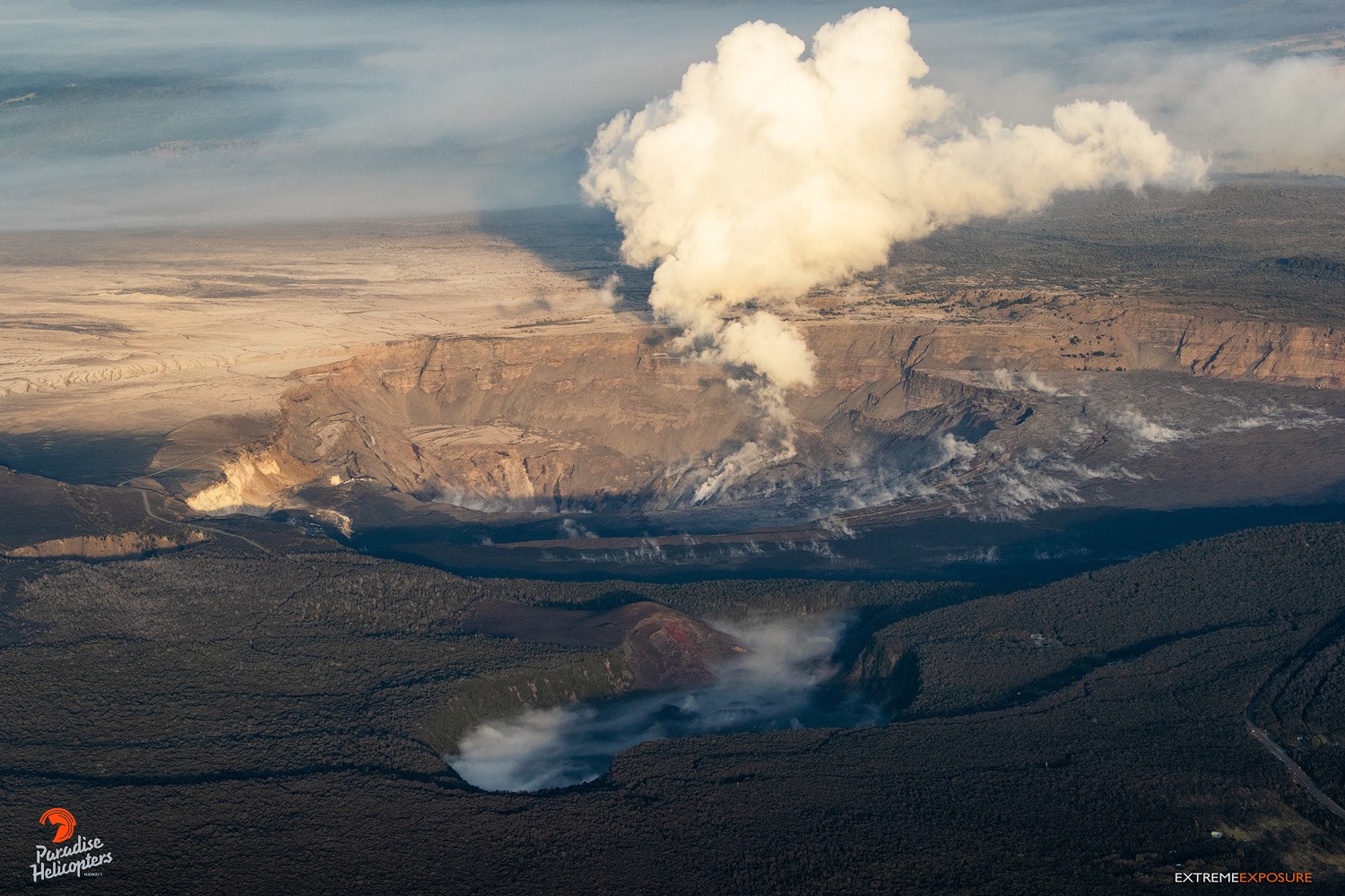
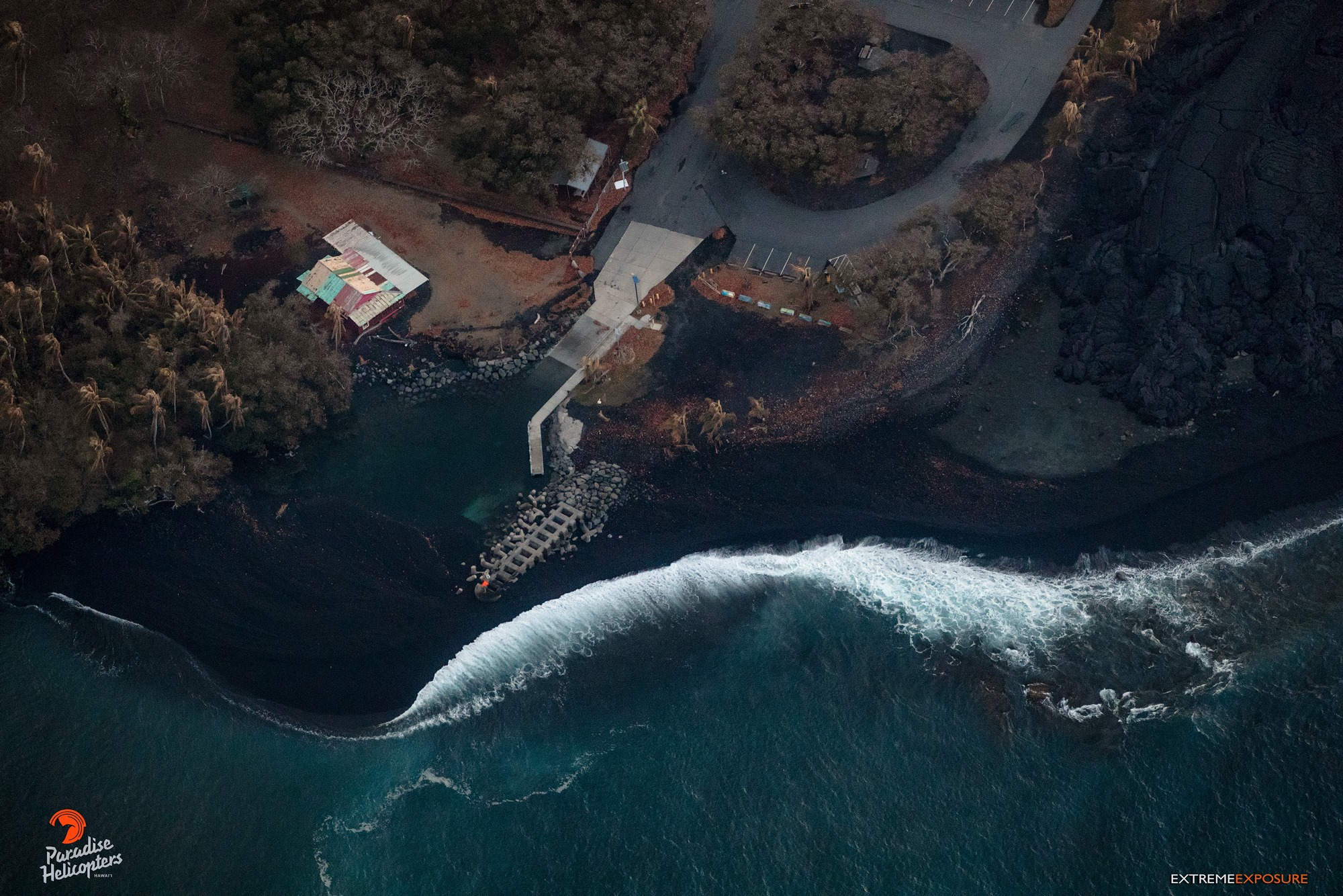
Hawai , Kilauea :
HVO/USGS Volcanic Activity Notice
Current Volcano Alert Level: WATCH
Previous Volcano Alert Level: WARNING
Current Aviation Color Code: ORANGE
Issued: Friday, August 17, 2018, 8:39 AM HST
Source: Hawaiian Volcano Observatory
Notice Number:
Location: N 19 deg 25 min W 155 deg 17 min
Elevation: 4091 ft (1247 m)
Area: Hawaii
Volcanic Activity Summary: Lowering Alert Level from WARNING to WATCH
In light of the reduced eruptive activity at Kīlauea Volcano over the last several days, HVO is lowering the Alert Level for ground based hazards from WARNING to WATCH. This change indicates that the hazards posed by crater collapse events (at the Kīlauea summit) and lava flows (Lower East Rift Zone; LERZ) are diminished. However, the change does not mean with absolute certainty that the LERZ eruption or summit collapses are over. It remains possible that eruption and collapse activity could resume.
Although no signs of imminent hazardous activity are present at this time, residents of the region near recently active fissures should stay informed, heed Civil Defense warnings, and be prepared, if necessary, to self-evacuate.
The aviation color code remains at ORANGE.
The Hawaiian Volcano Observatory (HVO) will continue to closely monitor Kīlauea’s seismicity, deformation, and gas emissions for any sign of reactivation, and maintain visual surveillance of the summit and LERZ. HVO will continue to issue daily updates and additional messages as needed.
Remarks: Background and Prognosis
Kīlauea Volcano has remained quiet for well over a week now, with no collapse events at the summit since August 2. Except for a small, crusted-over pond of lava deep inside the fissure 8 cone and a few scattered ocean entries, lava ceased flowing in the LERZ channel on August 6. Sulfur dioxide (SO2) emissions rates at the summit and LERZ are also drastically reduced (the combined rate is lower than at any time since late 2007).
It remains too soon to tell if this diminished activity represents a temporary lull or the end of the LERZ lava flows and/or summit collapses. In 1955, similar pauses of 5 and 16 days occurred during an 88-day-long LERZ eruption. During the Mauna Ulu eruption (1969-1974), a 3.5 month pause occurred in late 1971.
HVO will continue to record detailed visual observations and scrutinize incoming seismic, deformation, and gas data, looking for evidence of significant movement of magma or pressurization as would be expected if the system was building toward renewed activity.
Source : HVO
Photo s: Bruce Omori / Extreme Exposure Fine Art Gallery
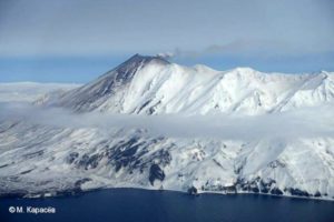
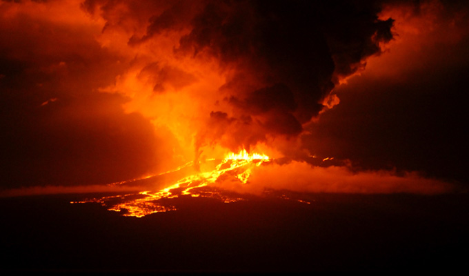
Ecuador / Galapagos , Sierra Negra :
Update of eruptive activity
RESUME :
The eruption of the Sierra Negra volcano began this year on June 26, and continues until now with the emission of lava flows. However, the intensity of the rash was variable and several pulses of increased activity were recognized. The number of earthquakes per day recorded by the IG-EPN network as of July 31st is 121 events and this number is smaller compared to previous days. However, seismicity continues, being higher than at baseline levels prior to June 26th, which was 38 earthquakes per day.
The highest activity impulses were recorded on August 4 and 9. The activity has decreased in intensity in recent days, but the lava flows apparently continue to enter the sea as seen in satellite images of August 15. It should be noted that the area where eruptive activity is still ongoing, the Elizabeth Bay area, where the lavas apparently continue to enter the sea, is far from any human population or agricultural activities and is only accessible by boat .
SEISMIC MONITORING
From the beginning of the eruption of Sierra Negra, an increase in the number of earthquakes and their magnitude was highlighted. Between June 26 and July 30, an average of 265 earthquakes per day was recorded. The maximum number of events was recorded on June 29 with 940 earthquakes. In recent days, since July 31, the number of earthquakes per day is 121, that is to say, it continues to be higher than the level recorded before June 26, 38 earthquakes per day (Fig 1 ). As of June 26, there have been several episodes of volcanic tremors that will be analyzed later ..
It should be noted that since June 26, there have been 15 earthquakes of magnitude greater than M4.0. The most important were the earthquake of July 4 at 18:30 (TG) of magnitude M5,2, that of July 22 at 12:16. with a magnitude of M4.7, the same day at 12:49 with a magnitude of M4.8 and that of July 25 at 9:47 with a magnitude of M4.9 with an epicenter in the southern part of the island.
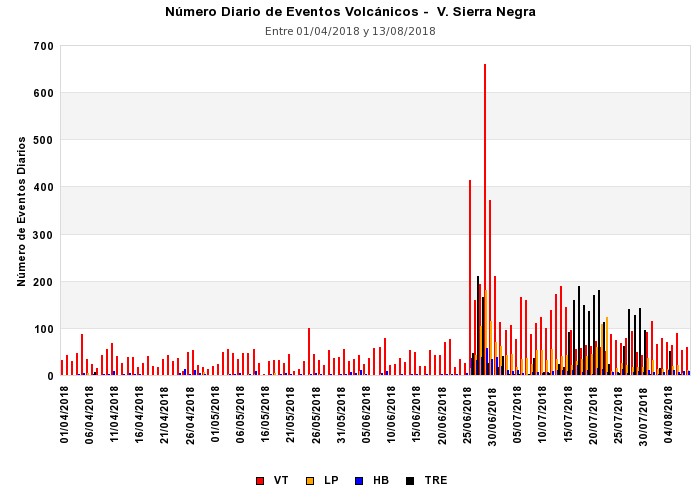
Figure 1.- Daily number of earthquakes on the Sierra Negra volcano. The increase in the number of earthquakes since the beginning of the eruptive activity on June 26, 2018 is highlighted.
Volcanic tremor:
It was very interesting to note that the June 26 eruption was accompanied by an intense seismic tremor at the VH1 station, the closest to the active vents at that time. A weak tremor signal has also been recorded in the acoustic component. Subsequently, smaller seismic tremor pulses were recorded, which decreased their amplitudes with time. The most significant seismic events took place on the 1st, 2nd, 8th and 30th of July. In August, they were recorded on days 4 and 8 (Figure 2). The highest spectral amplitudes were in the order of 1 to 4 Hz, which precludes its origin being related to microseismic noise generated by disturbances within the ocean.
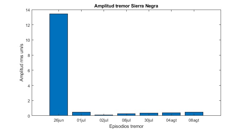
Figure 2.- Normalized amplitude of tremor episodes, with date of occurrence.
THERMAL SURVEILLANCE AND ERUPTION INTENSITY:
In FIG. 3, a graph of the amount of heat (radiant energy) generated during the current eruptive phase, detected by the infrared sensors of the MODVOLC satellite system and which can be associated with the intensity of the eruptive activity. As indicated in our previous report (Special Report No. 16), several activity impulses were recorded in which the intensity of the eruption increased: at the beginning of June 26, and later, other peaks were detected: 2, 8, 10, 13, 18 and 23 July. All of these activity impulses occurred in the vent located in the lower portion of the north flank of the volcano (Crack 4) with the exception of lava emissions that occurred on the first day of the eruption along the fissures. located on the middle and upper flanks (cracks 1, 2,3 and 5).
Subsequently, another pulse of activity was detected on July 28 when it was observed that in general the size of these pulses decreased (Fig. 3). However, on August 4, a new impulse of activity was recorded, the intensity was higher and on August 9, the pulse was even more important (8,298 MWatts) and the second after the pulse of July 2 (11 778 MWatts), according to data provided by MODVOLC. As of August 9, the number and intensity of thermal anomalies had decreased, as reported by MODVOLC (Fig. 1), MIROVA (Fig. 4) and FIRMS. This would show that at present the eruption continues with the emission of lava from crack 4, the only one currently active, that the intensity of the eruption has decreased and that until August 15, we could observe on the satellite images that the lava continued to penetrate into the sea.
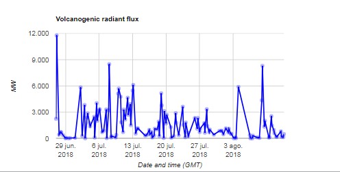
Figure 3.- Measurement of the heat (radiant flux) generated by the eruption between June 26 and August 15, 2018, according to the information provided by the MODVOLC satellite system.
…/…
CONCLUSIONS
The eruption of the Sierra Negra volcano, which began on June 26 this year, continues with the emission of lava flows that apparently continue to enter the sea.
Since July 31, the number of earthquakes per day is 121, a decrease from what has been recorded since the beginning of the eruption until that date. In any case, the seismicity continues to be higher than the level before June 26, 38 earthquakes per day.
Since the beginning of the eruption, the intensity of the activity has been variable and several high activity pulses have been recognized. In recent days, new eruptive pulses have been recognized, the most important being recorded on August 4 and 9, after which this activity has slightly decreased. These increased activity impulses were accompanied by significant episodes of seismic tremor.
As stated in the previous report (Special Report No. 16), the interaction between hot lava and cold ocean water generates large explosions and large amounts of volcanic gases, which are a danger to people. on board ships nearby; As this situation continues to occur, it is recommended to avoid approaching these sites and maintain a safe distance.
It should also be noted that gas emissions are permanent and can reach concentrations that can cause discomfort in humans and affect vegetation. It is recommended not to approach lava emission areas or areas where the volcanic plume is observed.
The Geophysical Institute-EPN maintains frequent contacts with the authorities of the Galapagos National Park by communicating the evolution of the eruption and continuously continuing the activities of monitoring and assessment of the threat.
Source : IGEPN
Photo : blacknews.ro