
July 01 , 2018.
Kilauea , Hawai :
Saturday, June 30, 2018, 10:14 AM HST (Saturday, June 30, 2018, 20:14 UTC)
19°25’16 » N 155°17’13 » W,
Summit Elevation 4091 ft (1247 m)
Current Volcano Alert Level: WARNING
Current Aviation Color Code: ORANGE
Kīlauea Volcano Lower East Rift Zone
The eruption in the lower East Rift Zone (LERZ) continues with no significant change during the past 24 hours.
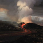
Fountains from Fissure 8 spatter cone continue to supply lava to the open channel with intermittent small, short-lived overflows. These overflows rarely extend beyond the existing flow field. No active overflows were observed during this morning’s helicopter overflight.The spatter cone is now about 55 m (180 ft) tall at its highest point, and fountains rarely rise above that point. At the coast, the northern margin of the flow field is still oozing fresh lava at several points in the area of Kapoho Beach Lots.
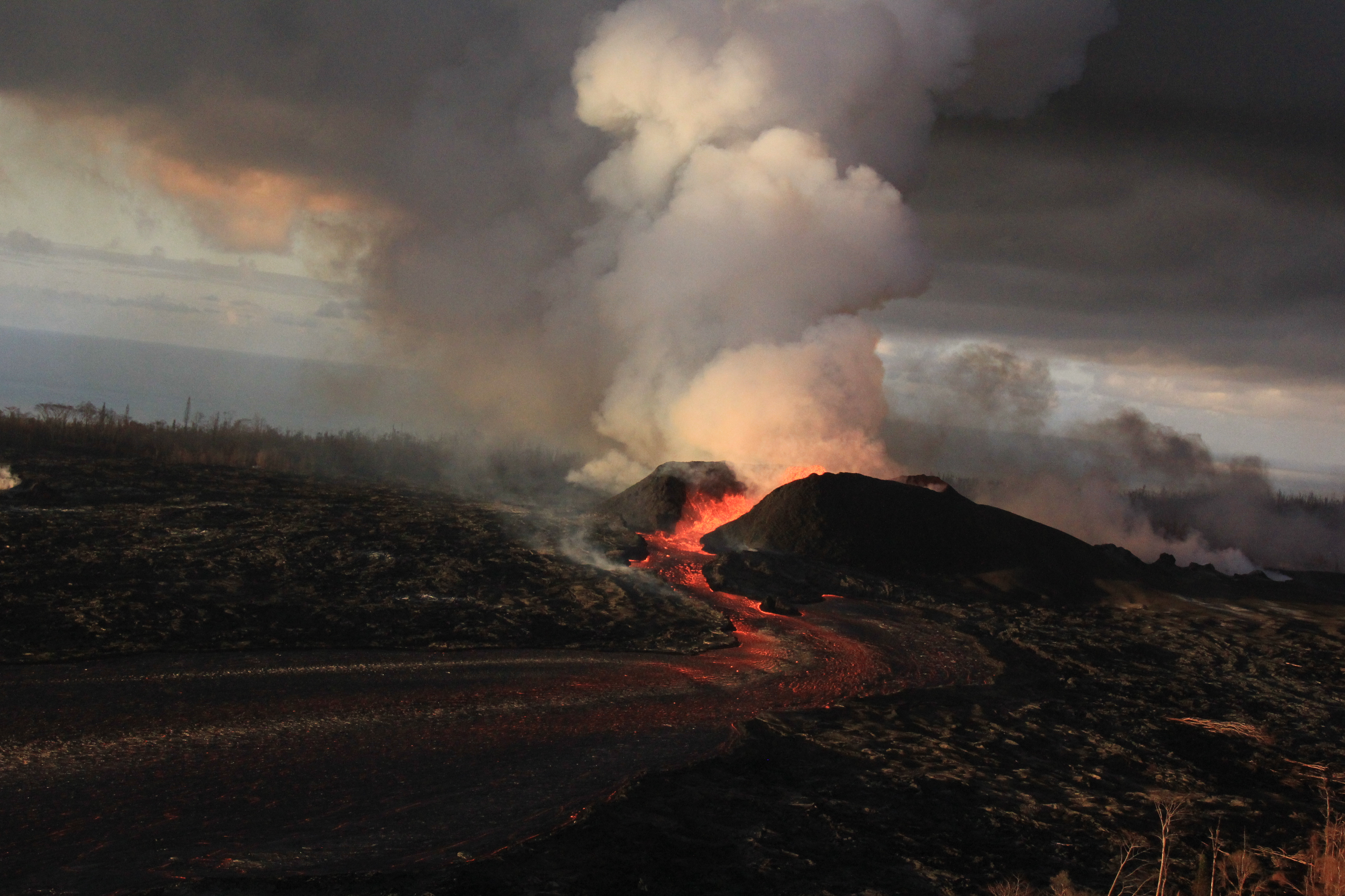
Fountains from the fissure 8 spatter cone continue to supply lava to an open channel. The spatter cone is now about 55 m (180 ft) tall at its highest point. As observed during this morning’s helicopter overflight, the fountains rarely rise above the rim of the spatter cone.
Lava was entering the sea over a broad area this morning primarily on the northern side of the entry area. As shown by yesterday’s thermal map of the flow field, the lava channel has crusted over about 0.8 km (0.5 mi) inland of the ocean entry; lava is moving beneath the crust and into still-molten interior of earlier flows before it enters the sea in multiple oozeouts.
Pele’s hair and other lightweight volcanic glass fragments from the lava fountain at Fissure 8 continue to fall downwind of the fissure, dusting the ground within a few hundred meters (yards) of the vent. High winds may waft lighter particles to greater distances. Residents are urged to minimize exposure to these volcanic particles, which can cause skin and eye irritation similar to volcanic ash.
HVO field crews are on site tracking the fountains, lava flows, and spattering from Fissure 8 as conditions allow and are reporting information to Hawaii County Civil Defense. Observations are also collected on a daily basis from cracks in the area of Highway 130; no changes in temperature, crack width, or gas emissions have been noted for several days.
Volcanic gas emissions remain very high from Fissure 8 eruptions.
The ocean entry is a hazardous area. Venturing too close to an ocean entry on land or the ocean exposes you to flying debris from sudden explosive interaction between lava and water. Also, the lava delta is unstable because it is built on unconsolidated lava fragments and sand. This loose material can easily be eroded away by surf, causing the new land to become unsupported and slide into the sea. Additionally, the interaction of lava with the ocean creates « laze », a corrosive seawater plume laden with hydrochloric acid and fine volcanic particles that can irritate the skin, eyes, and lungs.
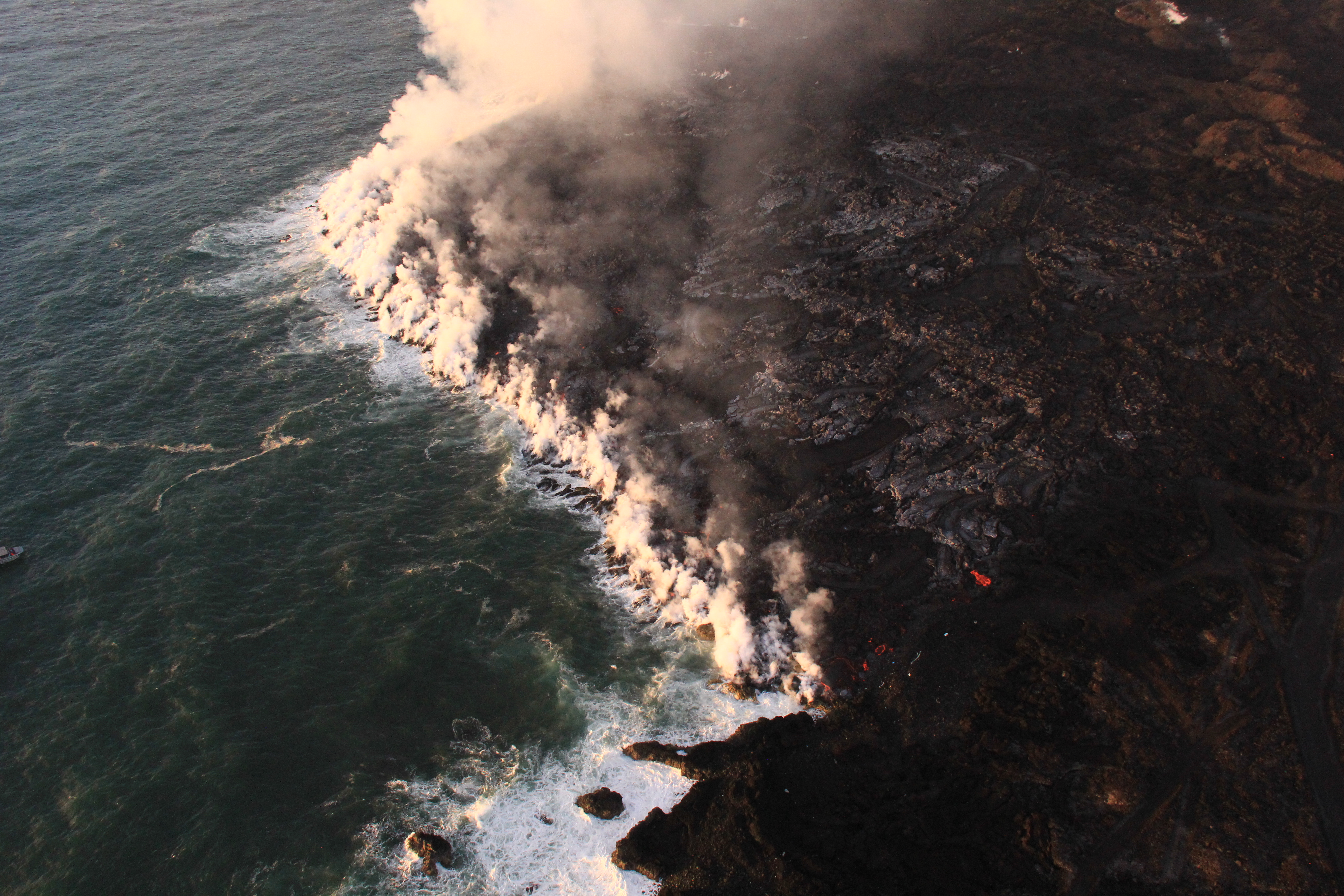
Lava was entering the ocean over a broad area this morning. This image shows an active entry area along the northern flow front at Kapoho. View to the south.
Magma continues to be supplied to the Lower East Rift Zone. Seismicity remains relatively low in the area with numerous small magnitude earthquakes and low amplitude background tremor. Higher amplitude tremor is occasionally being recorded on seismic stations close to the ocean entry.
Kīlauea Volcano Summit
After the collapse/explosive event at 07:51 AM HST yesterday, seismicity dropped abruptly from a high of 30-35 earthquakes per hour (many in the magnitude 2-3 range) prior to the collapse explosion down to 10 or fewer earthquakes per hour afterwards. This morning, the summit seismicity is again at 30-35 earthquakes per hour as we await the next collapse/explosive event. Inward slumping of the rim and walls of Halemaʻumaʻu continues in response to ongoing subsidence at the summit.
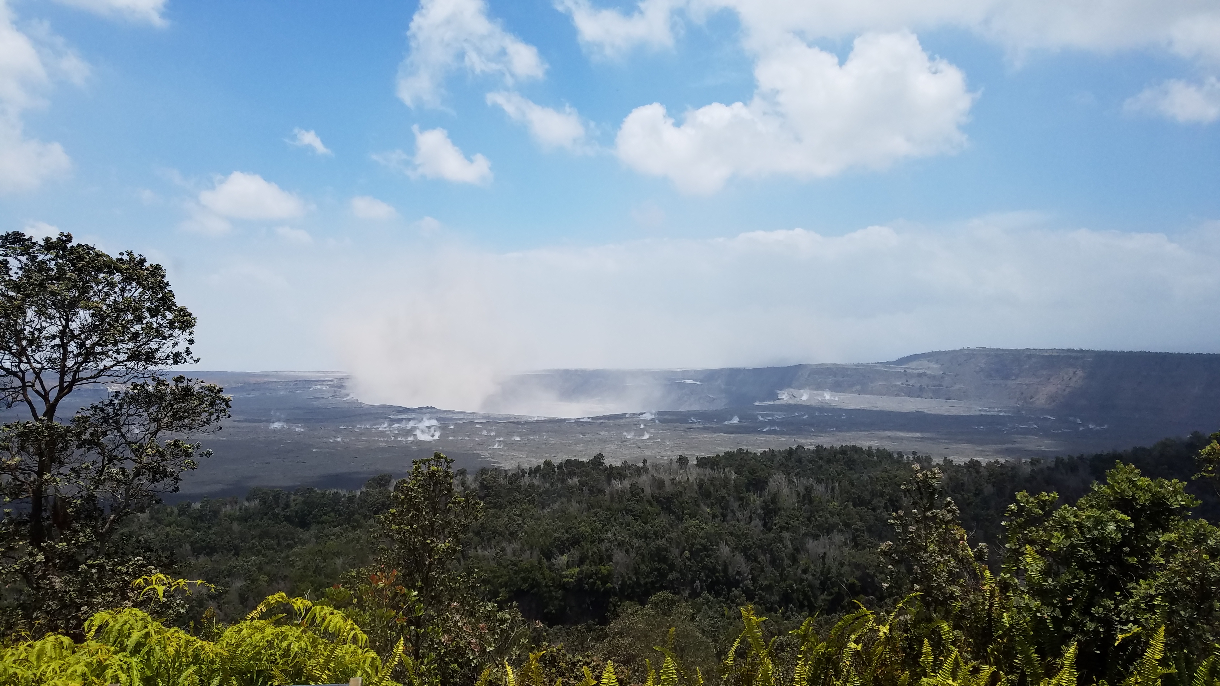
View of Kīlauea Volcano’s summit. The brown visible dust coming from Halema‘uma‘u is from rockfalls.
Sulfur dioxide emissions from the volcano’s summit have dropped to levels that are about half those measured prior to the onset of the current episode of eruptive activity. This gas and minor amounts of ash are being transported downwind, with small bursts of ash and gas accompanying intermittent explosive activity
Source : HVO.
Photos : USGS.
Vidéo : Hawaii County Civil Defense / Ryan Finlay.
Ebeko , Kamchatka :
VOLCANO OBSERVATORY NOTICE FOR AVIATION (VONA)
Issued: July 01 , 2018.
Volcano: Ebeko (CAVW #290380)
Current aviation colour code: ORANGE
Previous aviation colour code: orange
Source: KVERT
Notice Number:2018-57
Volcano Location: N 50 deg 41 min E 156 deg 0 min
Area: Northern Kuriles, Russia
Summit Elevation: 3791.68 ft (1156 m)
Volcanic Activity Summary:
A moderate explosive activity of the volcano continues. According to visual data by volcanologists from Severo-Kurilsk, explosions sent ash up to 3.2 km a.s.l., and an ash plume drift to the south-east from the volcano. Satellite data by KVERT showed the volcano was quiet.
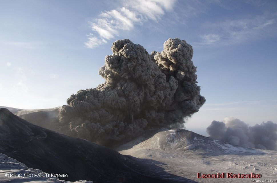
A moderate gas-steam with some amount of ash activity of the volcano continues. Ash explosions up to 16,400 ft (5 km) a.s.l. could occur at any time. Ongoing activity could affect low-flying aircraft and airport of Severo-Kurilsk.
Volcanic cloud height:
10496 ft (3200 m) AMSL Time and method of ash plume/cloud height determination: 20180701/0133Z – Visual data
Other volcanic cloud information:
Distance of ash plume/cloud of the volcano: 2 mi (3 km)
Direction of drift of ash plume/cloud of the volcano: SSE
Time and method of ash plume/cloud determination: 20180701/0133Z – Visual data
Source : Kvert
Photo : L. Kotenko, IVS FEB RAS , 10/12/2016 .
Fuego , Guatemala :
Type of activity: Vulcanian
Morphology: Composite Stratovolcano
Location: 14 ° 28’54˝ Latitude N; 90 ° 52’54˝ Longitude W.
Height: 3,763msnm.
The rains present today in the area of the Fuego volcano, generate lahars in the Canyon Seca and the Mineral river, these canals are tributaries of the Pantaleón river, whose flow considerably increases.
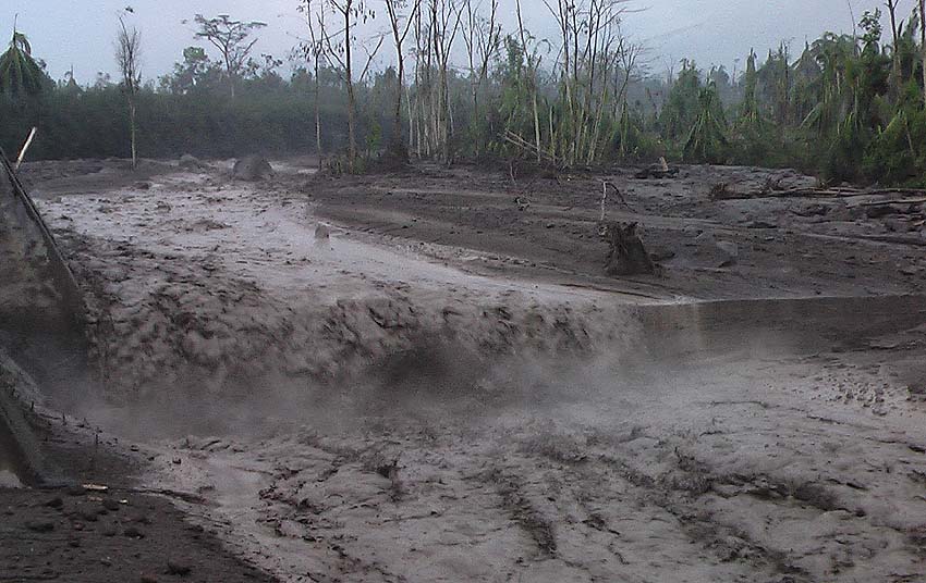
These lahars are presented with abundant fine materials making them pasty, they drag blocks of 2-3 meters in diameter, trunks and branches of trees, which generates vibrations in their path. These are materials of the recent eruption that descend, feeling the smell of Sulfur and emanating steam in their path.
Due to the rains that can be generated in the afternoon and evening, the probability of lahars occurring in one of the main ravines is not excluded.
Source : Insivumeh
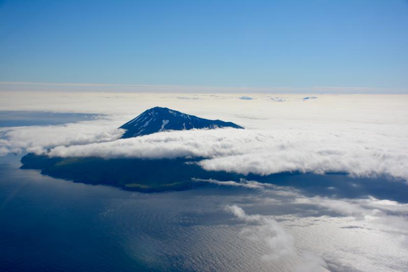
Cleveland , Alaska :
52°49’20 » N 169°56’42 » W,
Summit Elevation 5676 ft (1730 m)
Current Volcano Alert Level: WATCH
Current Aviation Color Code: ORANGE
Unrest continues at Cleveland volcano. Elevated surface temperatures at the summit were observed in satellite data over the past day. These thermal signals are consistent with observations earlier this week of a lava flow in the summit crater and may be evident now due to decreased cloud cover over the volcano. Low-level seismic activity is ongoing, but nothing unusual was observed in seismic or pressure sensor (infrasound) data over the past day.
Cleveland volcano is monitored by only two seismic stations, which restricts AVO’s ability to detect precursory unrest that may lead to an explosive eruption. Rapid detection of an ash-producing eruption may be possible using a combination of seismic, infrasound, lightning, and satellite data.
Source : AVO
Photo : Lyons, John , Juillet 2016


No comment yet, add your voice below!