July 16, 2020. EN . Japan : Nishinoshima , Italy / Sicily : Etna , Philippines : Bulusan , Chile : Nevados of Chillan , Japan : Suwanosejima .

July 16 ,  2020.


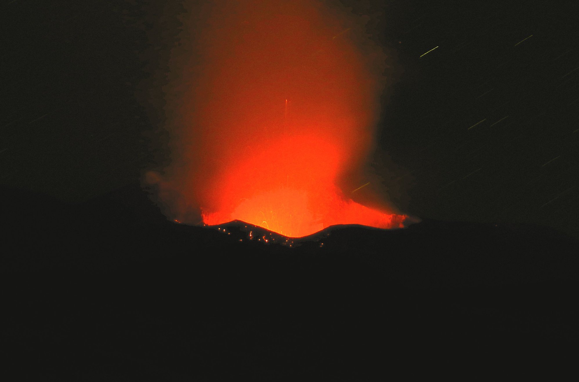
Japan , Nishinoshima :

About the active eruption activity on Nishinoshima:

Observations from the sea made by the oceanic weather observation vessel « Ryofu Maru » on July 11, the active eruption continued on Nishinoshima.
On July 11, the Japanese Meteorological Agency announced that the marine weather observation vessel « Ryofu Maru ».

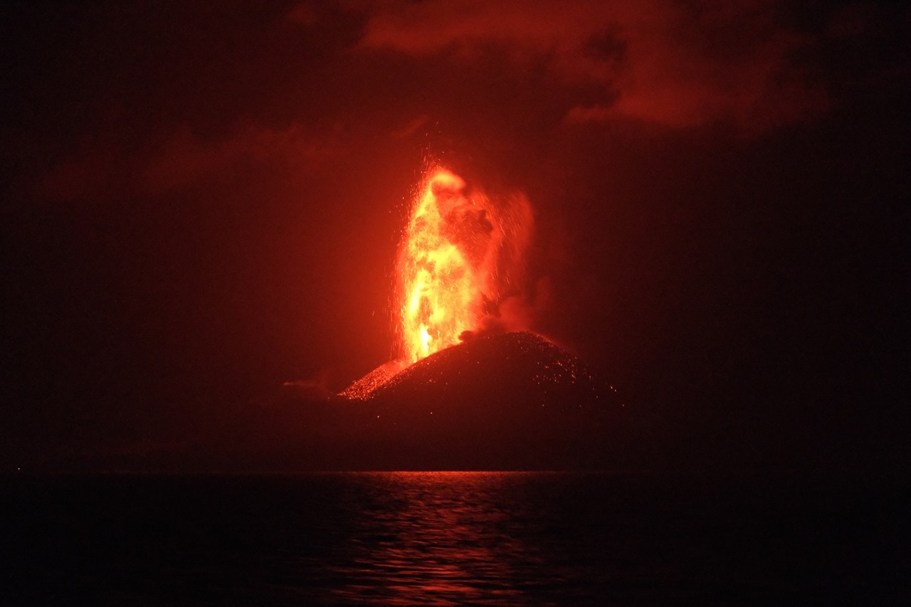
On Nishinoshima, a large amount of volcanic ash is continuously ejected from the summit crater, demonstrating an active eruption.
It has been confirmed that the fires have continued. In addition, large volcanic blocks are found at the foot of the pyroclastic cone.
At night, hot lava was emitted up to about 200 m above the edge of the crater.

Currently, a crater warning (risk of mountaineering) has been announced on Nishinoshima Island.
In a radius of about 2.5 km around the upper crater, large jets disperse along the trajectory of the eruption
Watch out for stones and lava flows.


The Japanese weather agency has two marine weather observation vessels (Ryofu Maru, Keifu Maru) which are used for ocean observations and ocean weather observations in the Pacific Northwest.
In addition to the above, long-distance observations, ash collections, volcanic gas samples from Itotorijima and Nishinoshima, where volcanic activity is active, as well as volcanic observations such as emission monitoring are also carried out .

Source : JMA.

Read the article (in Japanese) : https://www.jma.go.jp/jma/press/2007/15b/nishinoshima_200715.pdf?fbclid=IwAR3xIzD6X8CFS27KSORUkUVZt40xs2y7fJgjFJDMVGG2j3SLpj8TVngnaQA


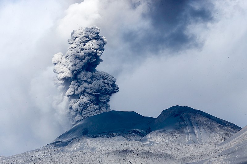
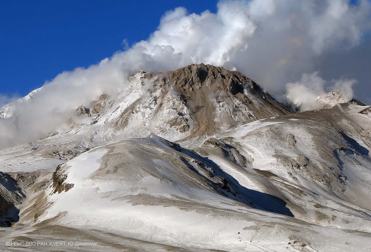
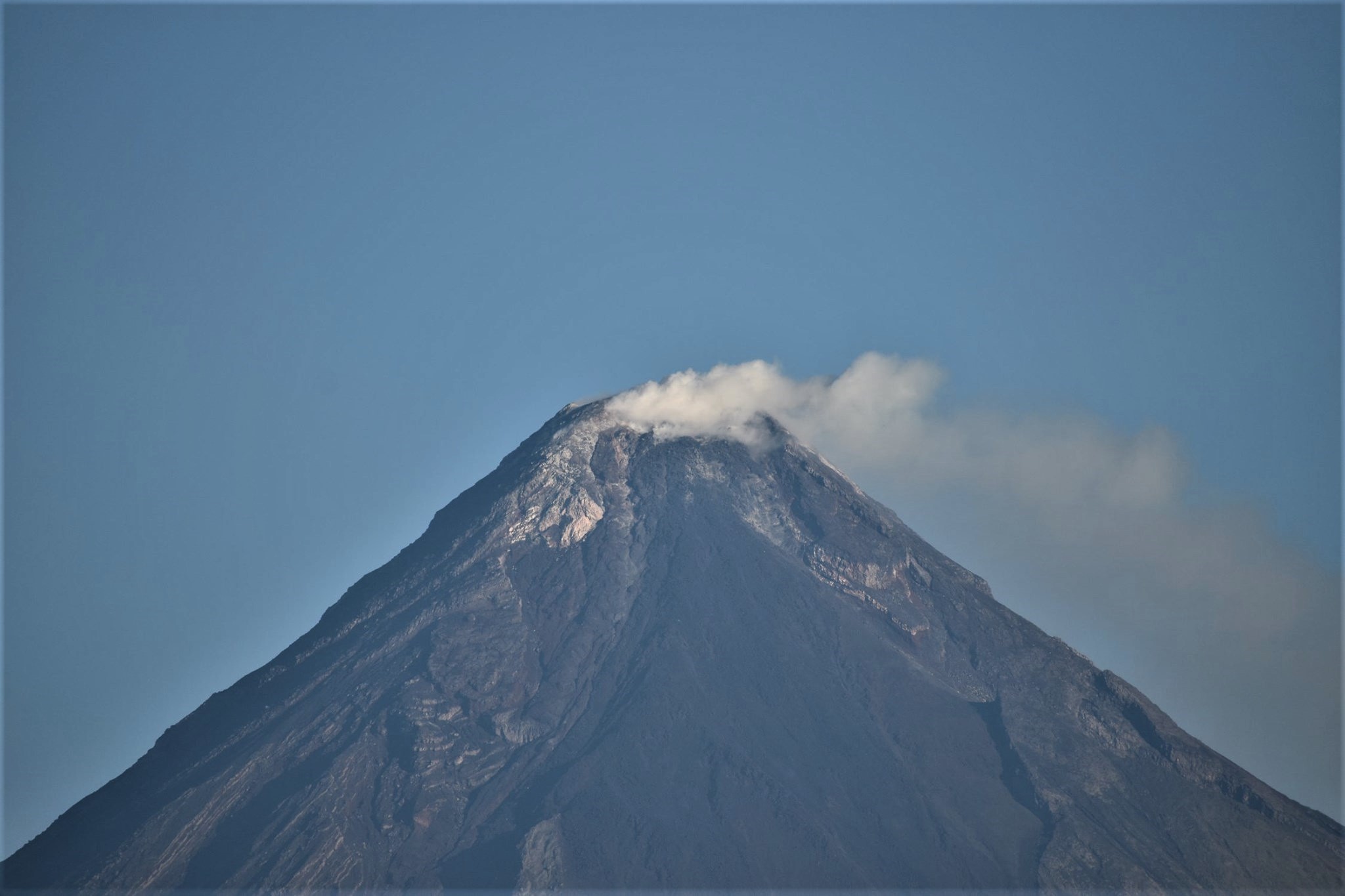
Italy / Sicily , Etna :

ETNA PRESS RELEASE [UPDATE n. 60]

The National Institute of Geophysics and Volcanology, Etneo Observatory, reports that from the early hours of the morning, a moderate increase in explosive activity was observed at the craters of New Southeast Crater and Voragine, which feed activity Strombolian of variable character with shreds emitted above the edges of the crater and weak ash emissions which disperse quickly near the summit area.

Regarding the amplitude of the volcanic tremor, there are no significant changes compared to what was communicated previously and shows oscillations, sometimes important, around average and sometimes high values. The location of the tremor source is in the New Southeast Crater (NSEC) area, at an altitude of 2,900 to 3,000 m. The infrasonic activity also shows no significant change and continues to be localized in the New Southeast Crater (NSEC) area.
Regarding the Etna soil deformation monitoring networks (GNSS and inclinometric), they did not show any significant variation.

Other updates will be communicated shortly.

Source et photo : INGV.


Philippines , Bulusan :

BULUSAN VOLCANO BULLETIN 16 July 2020 08:00 A.M.

Bulusan Volcano’s monitoring network recorded forty-six (46) volcanic earthquakes during the 24-hour observation period. Ground deformation data from continuous GPS measurements indicate short-term inflation of the edifice since late February 2020. These parameters indicate that volcanic processes are underway beneath the edifice that may be caused by deep-seated degassing or hydrothermal activity or magmatic intrusion.

Alert Level 1 (Abnormal) status prevails over Bulusan Volcano, which means that it is currently in an abnormal condition. Local government units and the public are reminded that entry into the four-kilometer radius Permanent Danger Zone (PDZ) is strictly prohibited and that vigilance within the two-kilometer Extended Danger Zone (EDZ) on the southeastern sector must be exercised due to the increased possibilities of sudden and hazardous phreatic eruptions. Civil aviation authorities must also advise pilots to avoid flying close to the volcano’s summit as ash from any sudden phreatic eruption can be hazardous to aircraft. Furthermore, people living within valleys and along river/stream channels especially on the southeast, southwest and northwest sector of the edifice should be vigilant against sediment-laden stream flows and lahars in the event of heavy and prolonged rainfall. DOST-PHIVOLCS is closely monitoring Bulusan Volcano’s condition and any new development will be communicated to all concerned stakeholders.

Source et photo : Phivolcs.


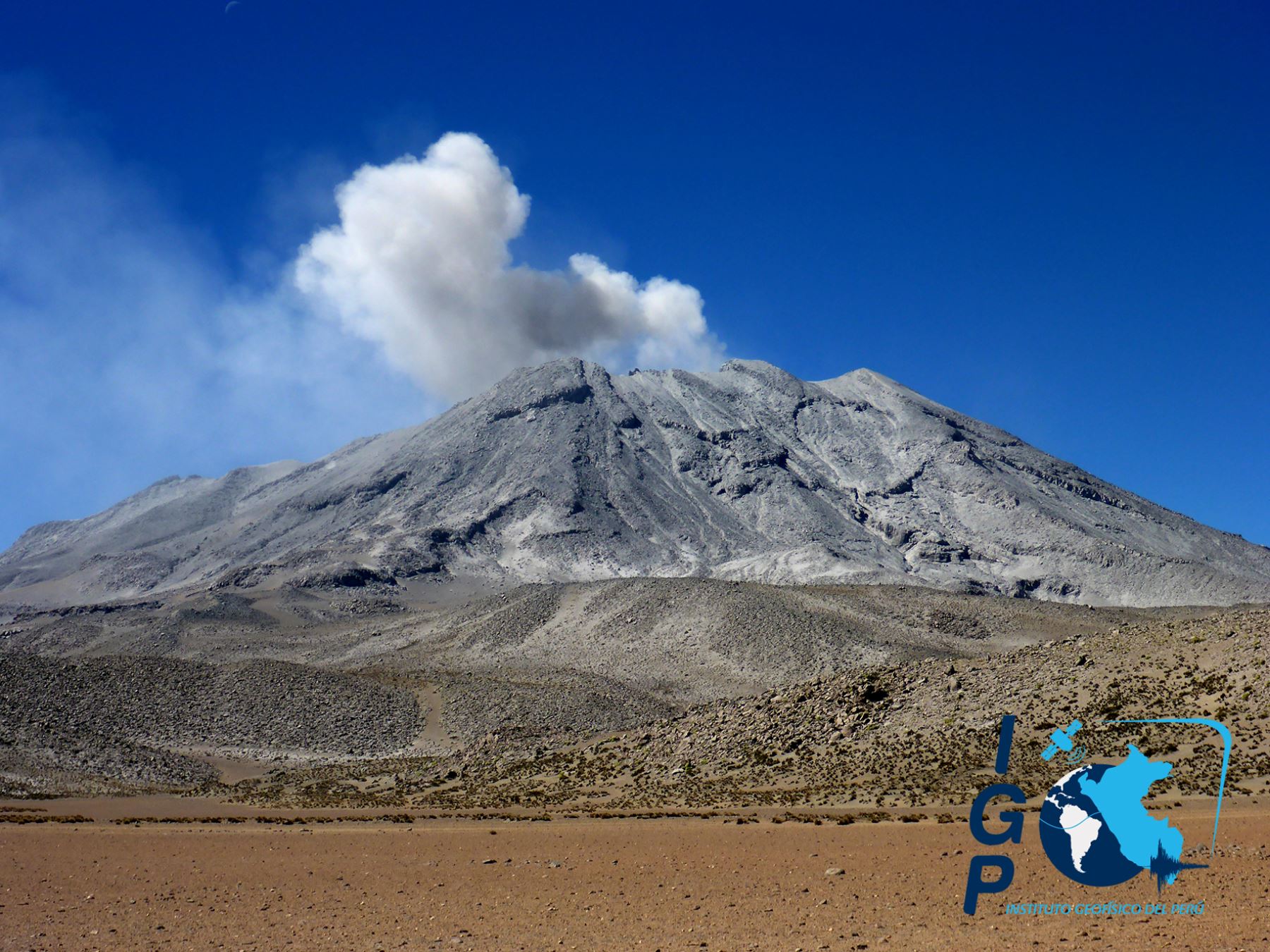
Chile , Nevados of Chillan :

Special report of volcanic activity (REAV), Region of Ñuble, volcanic complex of Nevados de Chillán
July 15, 2020, 7:50 p.m. Local time (Continental Chile)

The National Geological and Mining Service of Chile (Sernageomin) publishes the following information, obtained by the surveillance teams of the National Volcanic Surveillance Network (RNVV), processed and analyzed at the South Andean Volcanological Observatory (Ovdas):

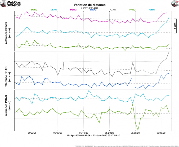
The eruptive cycle of the Nevados de Chillán volcanic complex (CVNCh) continues to evolve in a sustained manner and with significant changes. The data provided by the geodetic stations installed around the complex show significant variations in the movements of the stations, in the vertical and horizontal components. It is observed that the 3 closest stations to the crater rose between 2 and 4 cm approximately during the last 5 days, starting a new period of ascent / descent, as previously observed and reported. On the other hand, the horizontal displacements vary between 0.6 and 2.0 cm approximately over the same period. The station furthest from the crater, located more than 10 km from the active crater, shows no significant variations and its elevation during the last month was practically zero. Due to the above, it is concluded that the deformation is concentrated in areas closer to the active crater and therefore that the source of pressure which produces them would be at more superficial levels or related to the ascent and magmatic movements.


According to data reported by MIROVA (www.mirovaweb.it), thanks to the analysis of MODIS images, thermal alerts are maintained, with maximum values ​​of 3 MW for July 15, associated with the location of the lava flow .
Thanks to the analysis of SkySat Collect satellite images of July 13, 2020 and Sentinel L2A of July 14, 2020, the evolution of two effusive morphologies currently active in the Nicanor crater is recognized. First, the sustained advance of the lava flow called « L5 » is recorded (REAV Nevados de Chillán volcanic complex, July 2, 2020, 8:20 p.m. local time), with a 268 m extension from the edge of the crater in north direction. An average rate of advance of the L5 lava flow of 0.8 m / h was determined, with values ​​fluctuating between 0.2 m / h and 1.8 m / h. In addition, the development of a new lobe of the lava flow « L5 » is detected, whose extension has exceeded the eastern edge of the Nicanor crater, descending on the eastern slope up to 55 m. Its presence was first detected on July 14 from surveillance cameras and it was verified on thermal camera images that it had higher radiation values ​​than the rest of the volcanic building (similar to casting of lava « L5 »). On the other hand, the progression of another lava body called L6 is observed, which also exceeded the northern limit of the Nicanor crater, extending over 194 m on the northeast slope of the volcanic building and next to the L5 lava flow. The two effusive bodies correspond to the peaks of thermal radiation anomalies according to Sentinel L2A. However, the evolution of « L5 » and « L6 » shows differences in texture, speed and distribution, which is why they have so far been classified as separate items.

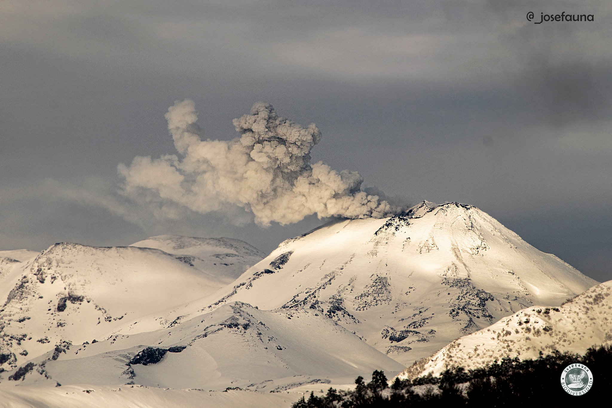
Regarding seismic data, the high seismicity production of fluids continues, linked to the extrusion of magmatic materials towards the surface and / or to intermittent explosions, accompanied by the emission of particulate matter of low to moderate heights. In addition, in recent weeks, high energy volcano-tectonic events have been recorded, with local magnitudes (ML) greater than or equal to 3.0.

Source : Sernageomin.

Photo et video : Josefauna.


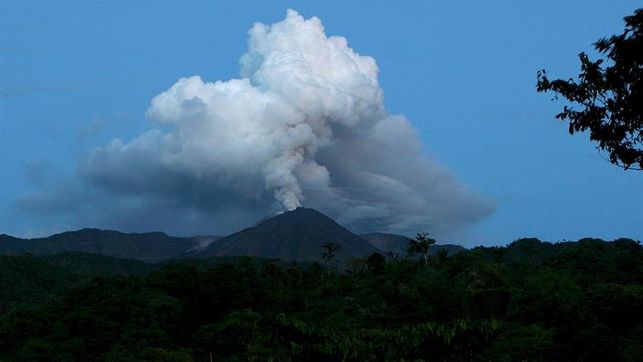
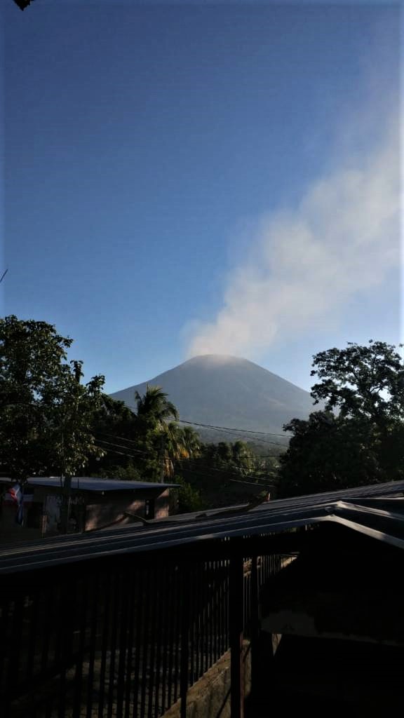
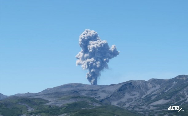
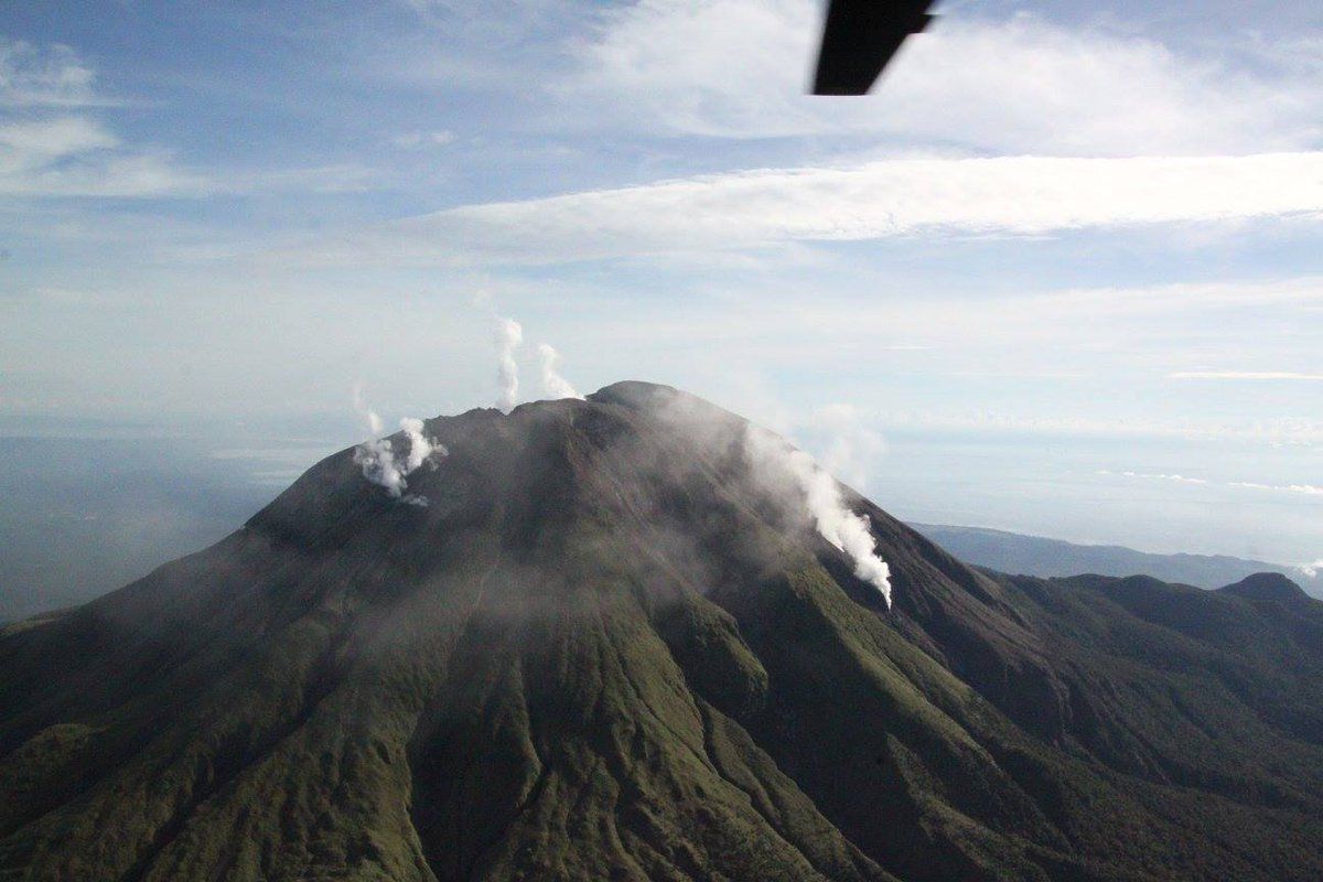
Japan , Suwanosejima :

29.638°N, 129.714°E
Elevation 796 m

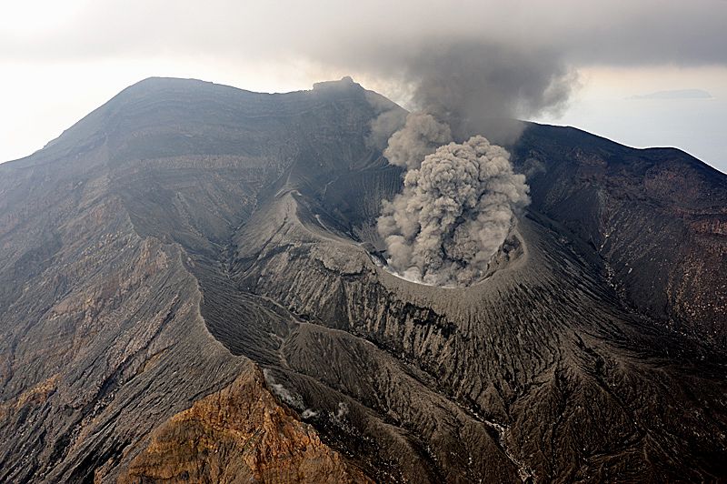
JMA reported that nighttime incandescence at Suwanosejima’s Ontake Crater was occasionally visible during 3-10 July. An eruptive event on 5 July generated a grayish white plume that rose 800 m above the crater rim and ejected material 300 m from the crater. The Tokyo VAAC noted that an ash plume rose to 2.1 km (7,000 ft) a.s.l. and drifted NE on 12 July based on satellite images and JMA information. The Alert Level remained at 2 (on a 5-level scale).

Sources: GVP ,Japan Meteorological Agency (JMA), Tokyo Volcanic Ash Advisory Center (VAAC) .

Photo :  H.Seo

July 13, 2020. EN. Hawaii : Mauna Loa , Alaska : Makushin , Philippines : Kanlaon , Ecuador : Sangay / Reventador , El Salvador : San Miguel (Chaparrastique) .

July 13 , 2020.


Hawaii, Mauna Loa :

19°28’30 » N 155°36’29 » W,
Summit Elevation 13681 ft (4170 m)
Current Volcano Alert Level: ADVISORY
Current Aviation Color Code: YELLOW

Activity Summary:
Mauna Loa Volcano is not erupting. Rates of deformation and seismicity have not changed significantly over the past week and remain above long-term background levels.


Observations:
During the past week, HVO seismometers recorded 56 small-magnitude (< M2.0) earthquakes on the volcano. Most of these earthquakes occurred at shallow depths of less than 8 kilometers (~5 miles) below sea level. The largest earthquake was a magnitude 3.3 (M3.3) event that occurred on the upper Southwest Rift Zone, on July 9.

Global Positioning System (GPS) measurements show long-term slowly increasing summit inflation, consistent with magma supply to the volcano’s shallow storage system.

Gas concentrations and fumarole temperatures at both the summit and the Sulphur Cone on the Southwest Rift Zone remain stable and below 2 ppm SO2 and ~98 C (206 F).

Webcams show no changes to the landscape.

Source : HVO.

Photo : GVP


Alaska , Makushin :

53°53’24 » N 166°55’30 » W,
Summit Elevation 5906 ft (1800 m)
Current Volcano Alert Level: ADVISORY
Current Aviation Color Code: YELLOW

Small earthquakes continue at Makushin as part of an earthquake sequence that started on June 15. No eruptive activity was observed in cloudy satellite views or in webcam images.

The earthquake sequence may be associated with volcanic unrest, but there have been no signs of deformation or surface activity noted in other monitoring data. It is likely that we would see additional signs of unrest prior to an eruption, should it occur. The volcano is monitored with a network of seismic and GPS instruments, a web camera, satellite data, and regional infrasound and lightning detection instruments.

If an eruption were to occur, the main hazard would likely be from airborne ash and ash fall.

Source : AVO.

Photo : Whitaker, Jacob ( 2019) .


Philippines , Kanlaon :

KANLAON VOLCANO BULLETIN 13 July 2020 08:00 A.M.

Kanlaon Volcano’s monitoring network recorded eighteen (18) volcano-tectonic earthquakes on the western flanks and three (3) volcanic earthquakes during the 24-hour observation period. Moderate emission of white steam-laden plumes that rose 500 meters before drifting northwest was observed. Sulfur dioxide (SO2) emission was measured at an average of 169 tonnes/day on 7 July 2020. Ground deformation data from continuous GPS measurements indicate a slight deflation of the lower and mid slopes since January 2020. However, short-term electronic tilt monitoring on the southeastern flanks recorded inflation on the lower to mid slopes that began on June 21, 2020. These parameters indicate hydrothermal or magmatic processes occurring beneath the edifice.

DOST-PHIVOLCS would like to remind the public that Kanlaon Volcano is at Alert Level 1, which means that it is at an abnormal condition and has entered a period of unrest. The local government units and the public are strongly reminded that entry into the 4-kilometer radius Permanent Danger Zone (PDZ) must be strictly prohibited due to the further possibilities of sudden and hazardous steam-driven or phreatic eruptions. Civil aviation authorities must also advise pilots to avoid flying close to the volcano’s summit as ejecta from any sudden phreatic eruption can be hazardous to aircraft.

DOST-PHIVOLCS is closely monitoring Kanlaon Volcano’s activity and any new development will be relayed to all concerned.

Source et photo : Phivolcs.


Ecuador , Sangay / Reventador :

SANGAY VOLCANO, MONDAY JULY 13, 2020.

The Geophysical Institute of the National Polytechnic School reports that:
Today, the SAGA seismic station records from 9:30 p.m. (TL) until now, a high frequency signal, associated with the appearance of mudslides and debris (lahars) that descend through the volcano gorges.

This phenomenon has been recurrent since May 2019 and it comes from the fact that the intense rains on the volcano, remobilize the material accumulated throughout these months of activity. Proximity to rivers is not recommended.
The Geophysical Institute of the National Polytechnic School monitors activity in the volcano and will inform of changes that may be recorded.

REVENTADOR VOLCANO :

DAILY REPORT OF THE CONDITION OF THE VOLCANO REVENTADOR, Monday July 13, 2020.
Information Geophysical Institute – EPN.

Surface activity level: Moderate, Surface trend: Rising.
Internal activity level: High, Internal trend: No change.

Seismicity: From July 11, 2020, 11:00 a.m. to July 12, 2020, 11:00 a.m.
Long Period Type (LP): 45 events
Explosions (EXP): 38 events
Emission tremors (TE): 5 events
Harmonic Tremors (TA): 3 events.

Rains / lahars: Not recorded.

Emission / ash column: Various emissions of gas and ash have been observed with heights up to 600 meters, as well as other emissions greater than 1000 meters above the crater level, dispersing in the west direction and North West. The Washington VAAC has reported gas and ash emissions up to 988 meters above the summit in a westerly and northwestern direction.

Other monitoring parameters: no change.

Observations: The sector of the volcano was cleared from dawn until the beginning of the morning today, the rest of the weather remained mainly cloudy. In the early morning, an incandescence was observed in the crater and blocks rolled up to 500 meters below the summit on all sides of the volcano. For the moment, the volcano is cloudy.

Alert level: Orange.

Source : IGEPN.

Photo : EDIIMA 


El Salvador , San Miguel (Chaparrastique) :

Location: San Miguel Department
Altitude: 2130 meters above sea level
Type of volcano: Stratovolcan
Activity type: Strombolian-Vulcanian
Last major eruption: December 29, 2013.

During the month of June which has just passed, the volcano San Miguel presented a low level of activity considered in continuous phase, that is to say at its usual level. The seismic vibration continued to fluctuate between 60 and 85 RSAM units in the average day. No earthquake was perceived by the population living in the region.

Emissions of sulfur dioxide (SO2) remain low and emissions continue, indicating that the volcano’s magmatic system is continuing its crystallization process. In general, the activity of the volcano has remained stable, but it is not excluded that it suddenly changes as before, so it is suggested to mountaineers and the general population to avoid visiting the crater area.

Source : Marn .

Photo : Jorge Rivas

13 Juillet 2020. FR . Hawaii : Mauna Loa , Alaska : Makushin , Philippines : Kanlaon , Equateur : Sangay / Reventador , El Salvador : San Miguel (Chaparrastique) .

13 Juillet 2020.


Hawaii, Mauna Loa :

19 ° 28’30 « N 155 ° 36’29 » O,
Élévation du sommet : 13681 pi (4170 m)
Niveau actuel d’alerte volcanique: AVIS
Code couleur actuel de l’aviation: JAUNE

Résumé de l’activité:
Le volcan Mauna Loa n’est pas en éruption. Les taux de déformation et de sismicité n’ont pas changé de façon significative au cours de la semaine dernière et restent supérieurs aux niveaux de fond à long terme.


Observations:
Au cours de la semaine dernière, les sismomètres du HVO ont enregistré 56 tremblements de terre de petite magnitude (<M2,0) sur le volcan. La plupart de ces tremblements de terre se sont produits à des profondeurs peu profondes de moins de 8 kilomètres (~ 5 milles) sous le niveau de la mer. Le plus grand tremblement de terre a été un événement de magnitude 3,3 (M3,3) qui s’est produit dans la zone supérieure du Rift Sud-Ouest, le 9 juillet.

Les mesures du système de positionnement mondial (GPS) montrent une inflation du sommet à long terme qui augmente lentement, compatible avec l’approvisionnement en magma du système de stockage peu profond du volcan.

Les concentrations de gaz et les températures des fumerolles au sommet et à Sulphur Cone , dans la zone de Rift Sud-Ouest restent stables et inférieures à 2 ppm de SO2 et ~ 98 C (206 F).

Les webcams ne montrent aucun changement au paysage.

Source : HVO.

Photo : GVP


Alaska , Makushin :

53 ° 53’24 « N 166 ° 55’30 » O,
Élévation du sommet : 5906 pi (1800 m)
Niveau actuel d’alerte volcanique: AVIS
Code couleur actuel de l’aviation: JAUNE

De petits tremblements de terre se poursuivent sur le Makushin dans le cadre d’une séquence de tremblements de terre qui a commencé le 15 juin. Aucune activité éruptive n’a été observée dans les vues satellite nuageuses ou dans les images webcam.

La séquence de tremblement de terre peut être associée à des troubles volcaniques, mais aucun signe de déformation ou d’activité de surface n’a été noté dans d’autres données de surveillance. Il est probable que nous verrions des signes supplémentaires de troubles avant une éruption, si cela se produisait. Le volcan est surveillé avec un réseau d’instruments sismiques et GPS, une caméra Web, des données satellite et des instruments régionaux de détection des infrasons et de la foudre.

Si une éruption devait se produire, le principal danger proviendrait probablement des cendres en suspension dans l’air et des chutes de cendres.

Source : AVO.

Photo : Whitaker, Jacob ( 2019) .


Philippines , Kanlaon :

BULLETIN D’ACTIVITE DU VOLCAN KANLAON , 13 juillet 2020 , 08:00 A.M.

Le réseau de surveillance du volcan Kanlaon a enregistré dix-huit (18) tremblements de terre volcano-tectoniques sur les flancs Ouest et trois (3) tremblements de terre volcaniques au cours de la période d’observation de 24 heures. On a observé une émission modérée de panaches blancs chargés de vapeur qui se sont élevés de 500 mètres avant de dériver vers le Nord-Ouest. Les émissions de dioxyde de soufre (SO2) ont été mesurées à une moyenne de 169 tonnes / jour le 7 juillet 2020. Les données de déformation du sol provenant de mesures GPS continues indiquent une légère déflation des pentes inférieures et moyennes depuis janvier 2020. Cependant, la surveillance électronique à court terme de l’inclinaison sur les flancs Sud-Est, a enregistré une inflation sur les pentes inférieures à moyennes qui ont commencé le 21 juin 2020. Ces paramètres indiquent des processus hydrothermaux ou magmatiques se produisant sous l’édifice.

Le DOST-PHIVOLCS souhaite rappeler au public que le volcan Kanlaon est au niveau d’alerte 1, ce qui signifie qu’il se trouve dans un état anormal et est entré dans une période de troubles. Il est vivement rappelé aux collectivités locales et au public que l’entrée dans la zone de danger permanent (PDZ) d’un rayon de 4 kilomètres doit être strictement interdite en raison des possibilités supplémentaires d’éruptions soudaines et dangereuses , de vapeur ou phréatiques. Les autorités de l’aviation civile doivent également conseiller aux pilotes d’éviter de voler près du sommet du volcan car les éjectas de toute éruption phréatique soudaine peuvent être dangereux pour les avions.

Le DOST-PHIVOLCS surveille de près l’activité du volcan Kanlaon et tout nouveau développement sera relayé à toutes les personnes concernées.

Source et photo : Phivolcs.


Equateur , Sangay / Reventador :

VOLCAN SANGAY , LUNDI 13 JUILLET 2020.

L’Institut géophysique de l’École nationale polytechnique rapporte que:
Aujourd’hui, la station sismique SAGA enregistre à partir de 21h30 environ (TL) jusqu’à présent, un signal haute fréquence, associé à l’apparition de coulées de boue et de débris
(lahars) qui descendent par les gorges du volcan.

Ce phénomène est récurrent depuis mai 2019 et il provient du fait que les pluies intenses sur le volcan, remobilisent le matériel accumulé tout au long de ces mois d’activité. La proximité des rivières n’est pas recommandée.
L’Institut géophysique de l’École nationale polytechnique surveille l’activité dans le volcan et informera des changements qui pourraient être enregistrés.

VOLCAN REVENTADOR :

RAPPORT QUOTIDIEN DE L’ETAT DU VOLCAN REVENTADOR , Lundi 13 Juillet 2020.
Information Geophysical Institute – EPN.

Niveau d’activité Superficiel: Modérée , Tendance de surface : En hausse .
Niveau d’activité interne: Haut , Tendance interne : Pas de changement.

Sismicité : Du 11 Juillet 2020, 11:00h au 12 Juillet 2020, 11:00h :
Type Longue Période (LP): 45 événements
Explosions (EXP): 38 événements
Tremors d’émission (TE) : 5 événements
Tremors Harmoniques (TA) : 3 événements.

Pluies / lahars: Non enregistrés.


Emission / colonne de cendres: Diverses émissions de gaz et de cendres ont été observées avec des hauteurs allant jusqu’à 600 mètres, ainsi que d’autres émissions supérieures à 1000 mètres au-dessus du niveau du cratère, se dispersant dans le sens Ouest et Nord-Ouest. Le Washington VAAC a signalé des émissions de gaz et de cendres jusqu’à 988 mètres au-dessus du sommet en direction Ouest et Nord-Ouest.

Autres paramètres de surveillance: aucun changement.

Observations: Le secteur du volcan a été dégagé de l’aube jusqu’au début de la matinée d’aujourd’hui, le reste du temps est resté principalement nuageux. Au petit matin, une incandescence a été observée dans le cratère et des blocs ont roulé jusqu’à 500 mètres sous le sommet de tous les côtés du volcan. Pour le moment, le volcan est nuageux.

Niveau d’alerte: Orange.

Source : IGEPN.

Photo : EDIIMA 


El Salvador , San Miguel (Chaparrastique) :

Localisation: département de San Miguel
Altitude: 2130 mètres au-dessus du niveau de la mer
Type de volcan: Stratovolcan
Type d’activité: Strombolienne-Vulcanienne
Dernière éruption importante: 29 décembre 2013.

Au cours du mois de juin qui vient de s’écouler, le volcan San Miguel a présenté un faible niveau d’activité considéré en phase continue, c’est-à-dire à son niveau habituel . La vibration sismique a continué de fluctuer entre 60 et 85 unités RSAM en jour moyen. Aucun tremblement de terre n’a été perçu par la population vivant dans la région.

Les émissions de dioxyde de soufre (SO2) restent faibles et les émissions continuent, indiquant que le système magmatique du volcan maintient son processus de cristallisation. De manière générale, l’activité du volcan est restée stable, mais il n’est pas exclu qu’il change soudainement comme auparavant, il est donc suggéré aux alpinistes et à la population générale d’éviter de visiter la zone du cratère.

Source : Marn .

Photo : Jorge Rivas

July 07 , 2020. EN. Philippines : Bulusan , Peru : Sabancaya , Peru : Ubinas , Costa Rica : Turrialba , Indonesia : Dukono .

July 07 , 2020.


Philippines , Bulusan :

BULUSAN VOLCANO BULLETIN (UPDATED) 06 July 2020 06:00 P.M.

This serves as a notice for the raising of the alert status of Bulusan from Alert Level 0 (normal) to Alert Level 1 (abnormal).

Bulusan Volcano’s monitoring network has recorded a total of fifty-three (53) volcanic earthquakes since 03 July 2020 including forty-three (43) low frequency events that are associated with weak and shallow hydrothermal or magmatic gas activity within the edifice. The increased seismicity could be succeeded by steam-driven or phreatic eruptions at the summit crater or from flank vents on the upper to middle slopes, despite the absence of visible degassing or steaming from the active vents this year. Ground deformation data from continuous GPS measurements also indicate a short-term inflation of the edifice since late February 2020. These parameters indicate that volcanic processes are underway beneath the edifice that may be caused by deep-seated degassing or hydrothermal activity or magmatic intrusion.

Alert Level 1 (abnormal) status now currently prevails over Bulusan Volcano, which means that it is currently in an abnormal condition. Local government units and the public are reminded that entry into the four-kilometer radius Permanent Danger Zone (PDZ) is strictly prohibited and that vigilance within the two-kilometer Extended Danger Zone (EDZ) on the southeastern sector must be exercised due to the increased possibilities of sudden and hazardous phreatic eruptions. Civil aviation authorities must also advise pilots to avoid flying close to the volcano’s summit as ash from any sudden phreatic eruption can be hazardous to aircraft. Furthermore, people living within valleys and along river/stream channels especially on the southeast, southwest and northwest sector of the edifice should be vigilant against sediment-laden stream flows and lahars in the event of heavy and prolonged rainfall. DOST-PHIVOLCS is closely monitoring Bulusan Volcano’s condition and any new development will be communicated to all concerned stakeholders.

Source et photo : Phivolcs .


Peru , Sabancaya :

Analysis period: June 29 to July 5, 2020, Arequipa, July 6, 2020.
Alert level: ORANGE

The Peruvian Geophysical Institute (IGP) reports that the eruptive activity of the Sabancaya volcano remains at moderate levels; that is to say with the continuous recording of explosions with columns up to 3.5 km above the summit of the volcano and consequent emissions of ash and gas. Therefore, for the following days, no significant change is expected regarding its eruptive activity.

The IGP recorded and analyzed the occurrence of approximately 602 earthquakes of volcanic origin, associated with the circulation of fluids (magma, gas, etc.) on the Sabancaya volcano (Arequipa region). In addition, an average of 20 low to medium intensity explosions were recorded daily.


The monitoring of the deformation of the volcanic structure, using GNSS data (processed with fast orbits), does not present any significant anomalies; however, slight inflation was recorded in the North and Southeast sector of the Sabancaya. Visual surveillance identified columns of gas and ash up to 3.5 km above the summit of the volcano, which were scattered towards the South, South-East, North and North-East sectors of the Sabancaya.
Satellite surveillance identified the presence of 7 thermal anomalies with values ​​between 2 MW and 18 MW, associated with the presence of a body of lava on the surface of the crater of the volcano.

RECOMMENDATIONS:
• Maintain the volcanic alert level in orange.
• Do not approach within a radius of less than 12 km from the crater. In the event of ash fall, cover your nose and mouth with rags or wet masks. Keep doors and windows of houses closed.
• Implement prevention and mitigation actions in the face of increased volcanic activity.

Source : IGP.

Photo : Ministerio de Defensa del Perú


Peru , Ubinas :

Analysis period: June 29 to July 5, 2020, Arequipa, July 6, 2020
Alert level: ORANGE
Suggested alert level: GREEN

The Geophysical Institute of Peru (IGP) reports that the Ubinas volcano (Moquegua region) continued to record a slight increase in its seismic activity during the analysis period; therefore, it is suggested that the authorities and the population keep an eye on the bulletins issued by the IGP.

During the analysis period, the occurrence of 51 earthquakes with a magnitude less than M2.3 was identified, events associated with the fracturing processes of the rocks that occur inside the volcano. These earthquakes were located 4 km northeast and 3 km southeast of the volcano, at a depth of 6.8 km and 2.7 km, respectively. Similarly, 11 seismic signals were recorded, associated with the movements of volcanic fluids (water vapor and gas). There was no seismic activity related to the rise of magma.


Surveillance cameras recorded columns of gas and water vapor that reached heights up to 300 m above the summit of the volcano; these emissions were dispersed to the northeast and southeast sectors of the volcano.
The monitoring of the deformation of the volcanic structure and the satellite monitoring through the SENTINEL, OMI-NASA (SO2 gas) and MIROVA (thermal anomalies) systems did not record any anomalies during the period.

RECOMMENDATIONS:
• Stay informed at all times of the volcanic activity of Ubinas thanks to the bulletins published by the IGP: (http://www.igp.gob.pe/servicios/centro-vulcanologico-nacional/).
• Do not approach within a radius of less than 3 km around the crater of the volcano.
• Do not neglect preventive actions in the event of a possible increase in volcanic activity.

Source : IGP.


Costa Rica , Turrialba :

No significant change is observed in the gas observations, but there are oscillations. The CO2 / SO2 ratio varies approximately between 7.9 and 18.7; while the H2S / SO2 ratio remains between 0.2 and 0.5. On the other hand, the SO2 concentration varies between 2.3 and 3.2 ppm. Small ash emissions were observed by the webcam yesterday (July 4) at 12:45 p.m. and today at 12:50 a.m., 1:29 a.m. and 3:20 p.m. (GMT-6). Deformation data indicates a contraction of the volcanic building.


July 6, 2020. At 9 am, a passive emanation of ash was observed on the Turrialba volcano, reaching a few meters above the top of the crater. A fall of ash is reported in the upper parts of Goicoechea, Rancho Redondo and Vista de Mar.


At the time of this report, winds were blowing from the northwest.
Seismicity is dominated by LP type events.

Source : Ovsicori.


Indonesia , Dukono :

VOLCANO OBSERVATORY NOTICE FOR AVIATION – VONA.

Issued : July 07 , 2020 
Volcano : Dukono (268010)
Current Aviation Colour Code : ORANGE
Previous Aviation Colour Code : orange
Source : Dukono Volcano Observatory
Notice Number : 2020DUK57
Volcano Location : N 01 deg 41 min 35 sec E 127 deg 53 min 38 sec
Area : North Maluku, Indonesia
Summit Elevation : 3933 FT (1229 M)

Volcanic Activity Summary :
Eruption with volcanic ash cloud at 23h58 UTC (08h58 local).

Volcanic Cloud Height :
Best estimate of ash-cloud top is around 4573 FT (1429 M) above sea level, may be higher than what can be observed clearly. Source of height data: ground observer.

Other Volcanic Cloud Information :
Ash-cloud moving to west.

Remarks : Eruption and ash emission is continuing.

Source : Magma Indonésie.

Photo : Martin Rietze


07 Juillet 2020. FR . Philippines : Bulusan , Pérou : Sabancaya , Pérou : Ubinas , Costa Rica : Turrialba , Indonésie : Dukono .

07 Juillet 2020.


Philippines , Bulusan :

BULLETIN D’ACTIVITE DU VOLCAN BULUSAN (MIS À JOUR) , 06 juillet 2020 , 18h00 .

Cela sert de préavis pour l’augmentation du statut d’alerte du volcane Bulusan du niveau d’alerte 0 (normal) au niveau d’alerte 1 (anormal).

Le réseau de surveillance du volcan Bulusan a enregistré un total de cinquante-trois (53) tremblements de terre volcaniques depuis le 03 juillet 2020, y compris quarante-trois (43) événements de type basse fréquence qui sont associés à une activité hydrothermal faible et peu profonde ou une activité de gaz magmatiques à l’intérieur de l’édifice.  La sismicité accrue pourrait être remplacée par des éruptions de vapeur ou phréatiques depuis le cratère du sommet ou par des évents de flancs sur les pentes supérieures à moyennes, malgré l’absence de dégazage visible ou de vapeur depuis les évents actifs cette année. Les données de déformation du sol provenant de mesures GPS continues indiquent également une inflation à court terme de l’édifice depuis fin février 2020. Ces paramètres indiquent que des processus volcaniques sont en cours sous l’édifice qui peuvent être causés par un dégazage profond ou une activité hydrothermale ou une intrusion magmatique.

Le statut d’alerte de niveau 1 (anormal) prévaut actuellement sur le volcan Bulusan, ce qui signifie qu’il est actuellement dans un état anormal. Il est rappelé aux collectivités locales et au public que l’entrée dans la zone de danger permanent (PDZ) d’un rayon de quatre kilomètres est strictement interdite et que la vigilance dans la zone de danger étendu (EDZ) de deux kilomètres sur le secteur Sud-Est doit être exercée en raison de l’augmentation possibilités d’éruptions phréatiques soudaines et dangereuses. Les autorités de l’aviation civile doivent également conseiller aux pilotes d’éviter de voler près du sommet du volcan, car les cendres de toute éruption phréatique soudaine peuvent être dangereuses pour les avions. De plus, les personnes vivant dans les vallées et le long des canaux des rivières / cours d’eau, en particulier dans le secteur Sud-Est, Sud-Ouest et Nord-Ouest de l’édifice, doivent être vigilantes contre les écoulements et les lahars chargés de sédiments en cas de fortes pluies prolongées. Le DOST-PHIVOLCS surveille de près l’état du volcan Bulusan et tout nouveau développement sera communiqué à toutes les parties prenantes concernées.

Source et photo : Phivolcs .


Pérou , Sabancaya :

Période d’analyse: 29 juin au 5 juillet 2020 , Arequipa, 6 juillet 2020 .
Niveau d’alerte: ORANGE

L’Institut géophysique du Pérou (IGP) rapporte que l’activité éruptive du volcan Sabancaya reste à des niveaux modérés; c’est-à-dire avec l’enregistrement continu d’explosions avec des colonnes jusqu’à 3,5 km d’altitude au-dessus du sommet du volcan et d’émissions conséquentes de cendres et de gaz. Par conséquent, pour les jours suivants, aucun changement significatif n’est attendu concernant son activité éruptive.

L’IGP a enregistré et analysé la survenue d’environ 602 tremblements de terre d’origine volcanique, associés à la circulation de fluides (magma, gaz, etc.) sur le volcan Sabancaya (région d’Arequipa). De plus, une moyenne de 20 explosions d’intensité faible à moyenne ont été enregistrées quotidiennement.


Le suivi de la déformation de la structure volcanique, à l’aide de données GNSS (traitées avec des orbites rapides), ne présente pas d’anomalies significatives; cependant, une légère inflation a été enregistrée dans le secteur Nord et Sud-Est du Sabancaya. La surveillance visuelle a identifié des colonnes de gaz et de cendres jusqu’à 3,5 km d’altitude au-dessus du sommet du volcan, qui étaient dispersées vers les secteurs Sud, Sud-Est, Nord et Nord-Est du Sabancaya.
La surveillance par satellite a identifié la présence de 7 anomalies thermiques avec des valeurs comprises entre 2 MW et 18 MW, associées à la présence d’un corps de lave à la surface du cratère du volcan.

RECOMMANDATIONS:
• Maintenir le niveau d’alerte volcanique en orange.
• Ne pas s’ approcher dans un rayon inférieur à 12 km du cratère. En cas de chute de cendres, se couvrir le nez et la bouche avec des chiffons ou des masques humides. Garder les portes et les fenêtres des maisons fermées.
• Mettre en œuvre des actions de prévention et d’atténuation face à l’augmentation de l’activité volcanique.

Source : IGP.

Photo : Ministerio de Defensa del Perú


Pérou , Ubinas :

Période d’analyse: 29 juin au 5 juillet 2020, Arequipa, 6 juillet 2020
Niveau d’alerte: ORANGE
Niveau d’alerte suggéré: VERT

L’Institut géophysique du Pérou (IGP) rapporte que le volcan Ubinas (région de Moquegua) a continué d’enregistrer au cours de la période d’analyse une légère augmentation de son activité sismique; en conséquence, il est suggéré aux autorités et à la population de garder un œil sur les bulletins émis par l’IGP.

Au cours de la période d’analyse, l’occurrence de 51 tremblements de terre d’une magnitude inférieure à M2,3 a été identifiée, événements associés aux processus de fracturation des roches qui se produisent à l’intérieur du volcan. Ces tremblements de terre étaient situés à 4 km au Nord-Est et à 3 km au Sud-Est du volcan, à une profondeur de 6,8 km et 2,7 km, respectivement. De même, 11 signaux sismiques ont été enregistrés, associés aux mouvements des fluides volcaniques (vapeur d’eau et gaz). Il n’y a pas eu d’activité sismique liée à la remontée du magma.


Les caméras de surveillance ont enregistré des colonnes de gaz et de vapeur d’eau qui ont atteint des hauteurs allant jusqu’à 300 m au-dessus du sommet du volcan;  ces émissions ont été dispersées vers les secteurs Nord-Est et Sud-Est du volcan.
La surveillance de la déformation de la structure volcanique et la surveillance par satellite à travers les systèmes SENTINEL, OMI-NASA (gaz SO2) et MIROVA (anomalies thermiques) n’ont pas enregistré d’anomalies au cours de la période.

RECOMMANDATIONS:
• Rester informé à tout moment de l’activité volcanique de l’Ubinas grâce aux bulletins publiés par l’IGP: (http://www.igp.gob.pe/servicios/centro-vulcanologico-nacional/).
• Ne pas s’ approcher dans un rayon inférieur à 3 km autour du cratère du volcan.
• Ne pas négliger les actions préventives en cas d’augmentation éventuelle de l’activité volcanique.

Source : IGP.


Costa Rica , Turrialba :

Aucun changement significatif n’est observé dans les observations des gaz, mais on note des oscillations  . Le rapport CO2 / SO2 oscille approximativement entre 7,9 et 18,7; tandis que le rapport H2S / SO2 reste entre 0,2 et 0,5. En revanche, la concentration de SO2 varie entre 2,3 et 3,2 ppm. De petites émissions de cendres ont été observées par la webcam hier (4 juillet) à 12h45 et aujourd’hui à 00h50, 01h29 et 15h20 (GMT-6). Les données de déformation indiquent une contraction du bâtiment volcanique.


6 juillet 2020. À 9 heures du matin, une émanation passive de cendres a été observée sur le volcan Turrialba, atteignant quelques mètres au-dessus du sommet du cratère. Une chute de cendres est signalée dans les parties hautes de Goicoechea,  Rancho Redondo et Vista de Mar.


Au moment de ce rapport, les vents soufflaient du Nord-Ouest.
La sismicité est dominée par les événements de type LP.

Source : Ovsicori.


Indonésie , Dukono :

AVIS D’OBSERVATION DU VOLCAN POUR L’AVIATION – VONA.

Émis: 07 Juillet 2020 
Volcan: Dukono (268010)
Code couleur actuel de l’aviation: ORANGE
Code couleur de l’aviation précédent: orange
Source: Observatoire du volcan Dukono
Numéro de l’avis: 2020DUK57
Emplacement du volcan: N 01 deg 41 min 35 sec E 127 deg 53 min 38 sec
Région: Maluku Nord, Indonésie
Altitude du sommet: 3933 FT (1229 M).

Résumé de l’activité volcanique:
Éruption avec nuage de cendres volcaniques à 23h58 UTC (08h58 local).

Hauteur des nuages volcaniques:
La meilleure estimation du sommet du nuage de cendres est d’environ 1473 M (4573 FT) au-dessus du niveau de la mer, peut être plus élevée que ce qui peut être observé clairement. Source des données de hauteur: observateur au sol.

Autres informations sur les nuages volcaniques:
Nuage de cendres se déplaçant vers l’Ouest.

Remarques: L’éruption et l’émission de cendres se poursuivent.

Source : Magma Indonésie.

Photo : Martin Rietze


June 29, 2020. EN . Alaska : Makushin , Kamchatka : Sheveluch , Philippines : Kanlaon , Indonesia : Dukono , Ecuador : Sangay .

June 29 , 2020 .


Alaska , Makushin :

53°53’24 » N 166°55’30 » W,
Summit Elevation 5906 ft (1800 m)
Current Volcano Alert Level: ADVISORY
Current Aviation Color Code: YELLOW

Occasional small earthquakes continue at Makushin from an earthquake sequence that started on June 16. Clouds blocked views of the volcano in satellite and web camera images over the past day.

Makushin summit hike by Jacob Whitaker, August 8, 2019.

This earthquake sequence may be associated with volcanic unrest, but there have been no signs of deformation or surface activity noted in other monitoring data. It is likely that we would see additional signs of unrest prior to an eruption, should it occur. The volcano is monitored with a network of seismic and GPS instruments, a web camera, satellite data, and regional infrasound and lightning detection instruments.

If an eruption were to occur, the main hazard would likely be from airborne ash and ash fall. Wind trajectory plots and hypothetical ash fall model information is available at https://www.avo.alaska.edu/activity/Makushin.php These models are updated twice per day in a hypothetical mode and will be updated immediately if there is an eruption. Seismic data, web camera images, and information products are also available at this site.

Source : AVO.

Photo : Whitaker, Jacob.


Kamchatka , Sheveluch :

VOLCANO OBSERVATORY NOTICE FOR AVIATION (VONA).

Issued: June 28 , 2020
Volcano: Sheveluch (CAVW #300270)
Current aviation colour code: ORANGE
Previous aviation colour code: orange
Source: KVERT
Notice Number: 2020-144
Volcano Location: N 56 deg 38 min E 161 deg 18 min
Area: Kamchatka, Russia
Summit Elevation: 10768.24 ft (3283 m), the dome elevation ~8200 ft (2500 m)

Volcanic Activity Summary:
A growth of the lava dome continues, a strong fumarolic activity sometimes with some amount of ash, and an incandescence of the dome blocks and hot avalanches accompanies this process. A re-suspended ash extended about 140 km to the east from the volcano.
This eruption continues. Ash explosions up to 32,800-49,200 ft (10-15 km) a.s.l. could occur at any time. Ongoing activity could affect international and low-flying aircraft.

Volcanic cloud height:
8200-9840 ft (2500-3000 m) AMSL Time and method of ash plume/cloud height determination: 20200628/0030Z – NOAA 18 (4m5)

Other volcanic cloud information:
Distance of ash plume/cloud of the volcano: 87 mi (140 km)
Direction of drift of ash plume/cloud of the volcano: E / azimuth 95 deg
Time and method of ash plume/cloud determination: 20200628/0030Z – NOAA 18 (4m5)

Source : Kvert .

Photo : Yu. Demyanchuk, IVS FEB RAS, KVERT.


Philippines , Kanlaon :

KANLAON VOLCANO BULLETIN 29 June 2020 08:00 A.M.

Kanlaon Volcano’s seismic monitoring network recorded sixteen (16) volcano-tectonic earthquakes on the western flanks and four (4) volcanic earthquakes in the summit area during the 24-hour observation period. Moderate emission of white steam-laden plumes that rose 300 meters before drifting northeast and northwest was observed. Sulfur dioxide (SO2) emission was measured at an average of 116 tonnes/day on 27 June 2020. Ground deformation data from continuous GPS measurements indicate a slight deflation of the lower and mid slopes since January 2020. However, short-term electronic tilt monitoring on the southeastern flanks recorded inflation on the lower to mid slopes that began on June 21, 2020. These parameters indicate hydrothermal or magmatic processes occurring beneath the edifice.

DOST-PHIVOLCS would like to remind the public that Kanlaon Volcano is at Alert Level 1, which means that it is at an abnormal condition and has entered a period of unrest. The local government units and the public are strongly reminded that entry into the 4-kilometer radius Permanent Danger Zone (PDZ) must be strictly prohibited due to the further possibilities of sudden and hazardous steam-driven or phreatic eruptions. Civil aviation authorities must also advise pilots to avoid flying close to the volcano’s summit as ejecta from any sudden phreatic eruption can be hazardous to aircraft. DOST-PHIVOLCS is closely monitoring Kanlaon Volcano’s activity and any new development will be relayed to all concerned.

Source : DOST-PHIVOLCS.

Photo : Phivolcs .


Indonesia , Dukono :

VOLCANO OBSERVATORY NOTICE FOR AVIATION – VONA

Issued: June 28 , 2020
Volcano :Dukono (268010)
Current Aviation Colour Code: ORANGE
Previous Aviation Colour Code : orange
Source: Dukono Volcano Observatory
Notice Number: 2020DUK53
Volcano Location :N 01 deg 41 min 35 sec E 127 deg 53 min 38 sec
Area:North Maluku, Indonesia
Summit Elevation :3933 FT (1229 M)

Volcanic Activity Summary:
Eruption with volcanic ash cloud at 22h32 UTC (07h32 local).

Volcanic Cloud Height:
Best estimate of ash-cloud top is around 5533 FT (1729 M) above sea level, may be higher than what can be observed clearly. Source of height data: ground observer.

Other Volcanic Cloud Information:
Ash-cloud moving to west.

Remarks:
Eruption and ash emission is continuing.

Source : Magma Indonésie .

Photo : Rainwater Media via Sherine France.


Ecuador , Sangay :

DAILY REPORT OF THE STATE OF SANGAY VOLCANO, Sunday June 28, 2020.

Surface activity level: High, Surface trend: No change.
Internal activity level: High, Internal trend: No change.

Seismicity: From June 27, 2020, 11:00 a.m. to June 28, 2020, 11:00 a.m .:
Long-term events: 19
Explosions: 168
Transmission tremor: 4

Rains / lahars: Sporadic rains were reported, which did not generate lahars. The eruptive activity accumulates significant quantities of pyroclastic material on the sides of the Sangay volcano, which can trigger the descent of mudslides and debris (lahars). It is recommended not to approach rivers in the area. * In the event of heavy rain, lahars can be generated in the Volcán, Upano and other tributaries. *

Emission / ash column: A gas and ash emission was observed with a maximum height of 1500 meters above the summit dispersing in a northwest direction. The Washington VAAC reported gas and ash emissions with heights between 870 and 1170 meters above the summit in a west and northwest direction. There have been no reports of ash falling

Other monitoring parameters: No changes.

Observations: The volcanic sector cleared at the end of the afternoon yesterday, the rest of the time, it remained mainly cloudy.

Alert level: yellow.

Source : IGEPN.

Photo : el universo

29 Juin 2020 . FR . Alaska : Makushin , Kamchatka : Sheveluch , Philippines : Kanlaon , Indonésie : Dukono , Equateur : Sangay .

29 Juin 2020 .


Alaska , Makushin :

53 ° 53’24 « N 166 ° 55’30 » O,
Élévation du sommet : 5906 pi (1800 m)
Niveau d’alerte volcanique actuel: AVIS
Code couleur actuel de l’aviation: JAUNE

De petits tremblements de terre occasionnels se poursuivent sur le Makushin à partir d’une séquence de tremblements de terre qui a commencé le 16 juin. Des nuages ​​ont bloqué des vues du volcan sur les images satellite et les caméras Web au cours de la dernière journée.

Vue du sommet du Makushin par Jacob Whitaker, 8 août 2019.

Cette séquence de tremblement de terre peut être associée à des troubles volcaniques, mais aucun signe de déformation ou d’activité de surface n’a été noté dans d’autres données de surveillance. Il est probable que nous verrions des signes supplémentaires de troubles avant une éruption, si cela se produisait. Le volcan est surveillé avec un réseau d’instruments sismiques et GPS, une caméra Web, des données satellite et des instruments régionaux de détection des infrasons et de la foudre.

Si une éruption devait se produire, le principal danger proviendrait probablement des cendres en suspension dans l’air et des chutes de cendres. Les graphiques de trajectoire du vent et les informations sur les modèles de chute de cendres hypothétiques sont disponibles à https://www.avo.alaska.edu/activity/Makushin.php . Ces modèles sont mis à jour deux fois par jour en mode hypothétique et seront mis à jour immédiatement en cas d’éruption . Des données sismiques, des images de caméras Web et des produits d’information sont également disponibles sur ce site.

Source : AVO.

Photo : Whitaker, Jacob.


Kamchatka , Sheveluch :

AVIS D’OBSERVATION DU VOLCAN POUR L’AVIATION (VONA).

Délivré: 28 juin 2020
Volcan: Sheveluch (CAVW # 300270)
Code couleur actuel de l’aviation: ORANGE
Code couleur de l’aviation précédent: orange
Source: KVERT
Numéro de l’avis: 2020-144
Emplacement du volcan: N 56 deg 38 min E 161 deg 18 min
Région: Kamchatka, Russie
Altitude du sommet: 10768,24 pi (3283 m), l’élévation du dôme ~ 8200 pi (2500 m).

Résumé de l’activité volcanique:
La croissance du dôme de lave continue, une forte activité fumerolienne parfois avec une certaine quantité de cendres, une incandescence des blocs du dôme et des avalanches chaudes accompagne ce processus. Un nuage de cendres remis en suspension s’étendait à environ 140 km à l’Est du volcan.
Cette éruption continue. Des explosions de cendres jusqu’à 32800-49200 pi (10-15 km)d’altitude pourraient survenir à tout moment. L’activité en cours pourrait affecter les avions internationaux volant à basse altitude.

Hauteur des nuages ​​volcaniques:
8200-9840 ft (2500-3000 m) AMSL Temps et méthode de détermination du panache de cendres / hauteur des nuages: 20200628 / 0030Z – NOAA 18 (4m5)

Autres informations sur les nuages ​​volcaniques:
Distance du panache de cendres / nuage du volcan: 140 km
Direction de la dérive du panache de cendres / nuage du volcan: E / azimut 95 deg
Temps et méthode de détermination du panache de cendres / nuages: 20200628 / 0030Z – NOAA 18 (4m5).

Source : Kvert .

Photo : Yu. Demyanchuk, IVS FEB RAS, KVERT.


Philippines , Kanlaon :

BULLETIN D’ACTIVITE VOLCAN KANLAON , 29 juin 2020 , 08:00 A.M.

Le réseau de surveillance sismique du volcan Kanlaon a enregistré seize (16) tremblements de terre volcano-tectoniques sur les flancs Ouest et quatre (4) tremblements de terre volcaniques dans la zone du sommet au cours de la période d’observation de 24 heures. Des émissions modérées de panaches blancs chargés de vapeur qui se sont élevés de 300 mètres avant de dériver vers le Nord-Est et le Nord-Ouest ont été observées. Les émissions de dioxyde de soufre (SO2) ont été mesurées à une moyenne de 116 tonnes / jour le 27 juin 2020. Les données de déformation du sol provenant de mesures GPS continues indiquent une légère déflation des pentes inférieures et moyennes depuis janvier 2020. Cependant, selon la surveillance électronique à court terme de l’inclinaison sur les flancs Sud-Est, une inflation a été enregistrée sur les pentes inférieures à moyennes qui a commencé le 21 juin 2020. Ces paramètres indiquent des processus hydrothermaux ou magmatiques se produisant sous l’édifice.

Le DOST-PHIVOLCS souhaite rappeler au public que le volcan Kanlaon est au niveau d’alerte 1, ce qui signifie qu’il se trouve dans un état anormal et est entré dans une période de troubles. Il est vivement rappelé aux collectivités locales et au public que l’entrée dans la zone de danger permanent (PDZ) d’un rayon de 4 kilomètres doit être strictement interdite en raison des possibilités supplémentaires d’éruptions soudaines et dangereuses de vapeur ou phréatiques. Les autorités de l’aviation civile doivent également conseiller aux pilotes d’éviter de voler près du sommet du volcan, car les éjectas de toute éruption phréatique soudaine peuvent être dangereux pour les avions. Le DOST-PHIVOLCS surveille de près l’activité du volcan Kanlaon et tout nouveau développement sera relayé à toutes les personnes concernées.

Source : DOST-PHIVOLCS.

Photo : Phivolcs .


Indonésie , Dukono :

AVIS D’OBSERVATION DU VOLCAN POUR L’AVIATION – VONA

Émis: 28 Juin 2020 
Volcan: Dukono (268010)
Code couleur actuel de l’aviation: ORANGE
Code couleur de l’aviation précédent: orange
Source: Observatoire du volcan Dukono
Numéro de l’avis: 2020DUK53
Emplacement du volcan: N 01 deg 41 min 35 sec E 127 deg 53 min 38 sec
Région: North Maluku, Indonésie
Altitude du sommet: 3933 FT (1229 M).

Résumé de l’activité volcanique:
Éruption avec nuage de cendres volcaniques à 22h32 UTC (07h32 local).

Hauteur des nuages volcaniques:
La meilleure estimation du sommet du nuage de cendres se situe à environ 1733 M (5533 FT) au-dessus du niveau de la mer, ce qui peut être supérieur à ce qui peut être observé clairement. Source des données d’altitude: observateur au sol.

Autres informations sur les nuages volcaniques: nuage de cendres se déplaçant vers l’ouest.

Remarques: L’éruption et l’émission de cendres se poursuivent.

Source : Magma Indonésie .

Photo : Rainwater Media via Sherine France.


Equateur , Sangay :

RAPPORT QUOTIDIEN DE L’ETAT DU VOLCAN SANGAY , Dimanche 28 Juin 2020 .

Niveau d’activité Superficiel: Haut , Tendance de surface : Pas de changement .
Niveau d’activité interne: Haut , Tendance interne : Pas de changement.

Sismicité : Du 27 Juin 2020, 11:00 au 28 Juin 2020, 11:00 :
Evènements de type longue périodes : 19
Explosions : 168
Tremor d’émission : 4


Pluies / lahars: Des pluies sporadiques ont été signalées, qui n’ont pas généré de lahars. L’activité éruptive accumule des quantités importantes de matières pyroclastiques sur les flancs du volcan Sangay, ce qui peut déclencher la descente de coulées de boue et de débris (lahars). Il est recommandé de ne pas s’approcher des rivières du secteur. * En cas de fortes pluies, des lahars peuvent être générés dans les rios Volcán, Upano et autres affluents. *

Emission / colonne de cendres: Une émission de gaz et de cendres a été observée avec une hauteur maximale de 1500 mètres au-dessus du sommet se dispersant en direction du Nord-Ouest. Le Washington VAAC a signalé des émissions de gaz et de cendres avec des hauteurs comprises entre 870 et 1170 mètres au-dessus du sommet dans une direction Ouest et Nord-Ouest. Il n’y a eu aucun rapport de chute de cendres

Autres paramètres de surveillance: Sans changements .

Observations: Le secteur volcanique s’est dégagé en fin d’après-midi hier, le reste du temps , il est resté principalement nuageux.

Niveau d’alerte: jaune.

Source : IGEPN.

Photo : el universo

June 28, 2020. EN. Russia / Kurile Islands : Ebeko , Vanuatu Archipelago : Lopevi , Philippines : Taal / Mayon / Kanlaon , Guatemala : Fuego .

June 28 ,  2020.


Russia / Kuril Islands , Ebeko :

VOLCANO OBSERVATORY NOTICE FOR AVIATION (VONA)

Issued: June 27 , 2020.
Volcano: Ebeko (CAVW #290380)
Current aviation colour code: ORANGE
Previous aviation colour code: orange
Source: KVERT
Notice Number: 2020-141
Volcano Location: N 50 deg 41 min E 156 deg 0 min
Area: Northern Kuriles, Russia
Summit Elevation: 3791.68 ft (1156 m)

Volcanic Activity Summary:
A moderate eruptive activity of the volcano continues. According to visual data by volcanologists from Severo-Kurilsk, explosion sent ash up to 1.9 km a.s.l., an ash cloud is drifting to the south-east of the volcano.
This eruptive activity continues. Ash explosions up to 19,700 ft (6 km) a.s.l. could occur at any time. Ongoing activity could affect low-flying aircraft and airport of Severo-Kurilsk.

Volcanic cloud height:
6232 ft (1900 m) AMSL Time and method of ash plume/cloud height determination: 20200627/0324Z – Visual data

Other volcanic cloud information:
Distance of ash plume/cloud of the volcano: 3 mi (5 km)
Direction of drift of ash plume/cloud of the volcano: ESE / azimuth 110 deg
Time and method of ash plume/cloud determination: 20200627/0324Z – Visual data

Source : Kvert.


Vanuatu Archipelago , Lopevi :

16°30’23”S 169°20’18”E
Summit 4635ft (1413m)
Current Alert Level: Level 2

Lopevi volcano is continuing in the major unrest state. The Volcanic Alert Level remains at Level 2 .

Lopevi volcano activity is continuing to be unstable in the level of major unrest. With the current state, the volcanic activity is likely to increase at any time but it could also remain at the same level for a longtime. Volcanic hazards remain on the island of Lopevi due to the current ongoing volcanic activity. The danger zone for life safety is limited to on the island of Lopevi.

Latest observations and daily analysis of the Lopevi seismic data from the volcano monitoring system confirm that Lopevi volcanic activity conditions remains unstable and its activity is currently continuing in the high level of unrest. The activity continues to occur in the active craters near the summit crater. The volcano activity consists of continuous emission of steam plume.

In the past, small or short-lived eruptions have followed volcanic unrest at Lopevi. The chance for an eruptive phase to follow the current volcanic unrest, like in January 2017, is likely.

With this current volcanic activity, it is a useful reminder that eruptions can occur with little or no warning.

Source :Geohazard.

Photo : Auteur inconnu.


Philippines , Taal / Mayon / Kanlaon :

TAAL VOLCANO BULLETIN: 28 June 2020 08:00 A.M.

In the past 24-hour period, the Taal Volcano Network recorded one (1) volcanic earthquake that is associated mainly with rock-fracturing processes beneath and around the edifice. Weak steaming or fumarolic activity that drifted south-southwest was observed from fissure vents along the Daang Kastila Trail.

MAYON VOLCANO BULLETIN: 28 June 2020 08:00 A.M.

Mayon Volcano’s seismic monitoring network recorded one (1) volcanic earthquake during the 24-hour observation period. Moderate emission of white steam-laden plumes that crept downslope before drifting to the general west was observed. Sulfur dioxide (SO2) emission was last measured at an average of 591 tonnes/day on 23 June 2020. Ground deformation data from Precise Leveling surveys on 12–19 June 2020 indicate a slight inflation of the edifice relative to February 2020 survey. Electronic tilt data also indicated non-steady inflation of the middle to upper edifice that began in late 2019. This follows an inflationary trend that has been recorded by continuous GPS monitoring since the middle of 2019.

KANLAON VOLCANO BULLETIN: 28 June 2020 08:00 A.M.

Kanlaon Volcano’s seismic monitoring network recorded thirty (30) volcano-tectonic earthquakes on the western flanks and one (1) volcanic earthquake in the summit area during the 24-hour observation period. Moderate emission of white steam-laden plumes that rose 300 meters before drifting northwest was observed. Sulfur dioxide (SO2) emission was measured at an average of 116 tonnes/day on 27 June 2020. Ground deformation data from continuous GPS measurements indicate a slight deflation of the lower and mid slopes since January 2020. Short-term electronic tilt monitoring on the southeastern flanks recorded continuing deflation on the lower slopes but inflation on the mid slopes since April 2020. These parameters indicate that hydrothermal or magmatic activity is occurring beneath the edifice.

Source : Phivolcs.

Photos : Tomasz Lepich , Julien Monteillet , dost .


Guatemala , Fuego :

Atmospheric conditions: Clear
Wind: East Precipitation: 0.00 mm.

Activity:
The Fuego volcano observatory reports low to moderate explosions, ranging from 8 to 13 per hour, which are accompanied by columns of gray ash, reaching a height between 4500 and 4800 m (14 764 to 15 748 feet) which disperse in the west and southwest direction for a maximum distance of 15 kilometers. Incandescent pulses rose on the crater from 100 to 300 meters (328 to 984 feet).


The avalanches are moderate to strong in the direction of the Seca, Taniluyá, Ceniza, Lajas and Honda ravines with boulders reaching the vegetation. The explosions generated low to moderate rumblings, 4 loud ones were counted; with moderate to strong shock waves that vibrate the roofs and windows of neighboring cities. Weak sounds similar to those of a train locomotive were heard for 8 to 25 minutes. Ash falls are reported in the villages of: Panimaché I, Morelia, Santa Sofía, Finca Palo Verde, Sangre de Cristo, Yepocapa and others.

Source : Insivumeh.

Photo : Conred

28 Juin 2020. FR . Russie / Iles Kuriles : Ebeko , Archipel du Vanuatu : Lopevi , Philippines : Taal / Mayon / Kanlaon , Guatemala : Fuego .

28 Juin 2020.


Russie / Iles Kuriles , Ebeko :

AVIS D’OBSERVATION DU VOLCAN POUR L’AVIATION (VONA)

Délivré: 27 juin 2020.
Volcan: Ebeko (CAVW # 290380)
Code couleur actuel de l’aviation: ORANGE
Code couleur de l’aviation précédent: orange
Source: KVERT
Numéro de l’avis: 2020-141
Emplacement du volcan: N 50 deg 41 min E 156 deg 0 min
Région: Kuriles du Nord, Russie
Altitude du sommet: 3791,68 pi (1156 m)

Résumé de l’activité volcanique:
Une activité éruptive modérée du volcan se poursuit. Selon les données visuelles des volcanologues de Severo-Kurilsk, une explosion a envoyé des cendres jusqu’à 1,9 km d’altitude, un nuage de cendres dérive vers le Sud-Est du volcan.
Cette activité éruptive se poursuit. Des explosions de cendres jusqu’à 19700 ft (6 km) d’altitude pourraient survenir à tout moment. L’activité en cours pourrait affecter les avions volant à basse altitude et l’aéroport de Severo-Kurilsk.

Hauteur des nuages ​​volcaniques:
6232 ft (1900 m) AMSL Heure et méthode de détermination du panache de cendres / hauteur des nuages: 20200627 / 0324Z – Données visuelles

Autres informations sur les nuages ​​volcaniques:
Distance du panache de cendres / nuage du volcan: 5 km
Direction de la dérive du panache de cendres / nuage du volcan: ESE / azimut 110 deg
Temps et méthode de détermination du panache de cendres / nuages: 20200627 / 0324Z – Données visuelles.

Source : Kvert.


Archipel du Vanuatu  , Lopevi :

16 ° 30’23 ”S 169 ° 20’18” E
Sommet 4635ft (1413m)
Niveau d’alerte actuel: niveau 2

Le volcan Lopevi  poursuit son activité dans un état d’agitation majeur. Le niveau d’alerte volcanique reste au niveau 2.

L’activité du volcan Lopevi continue d’être instable au niveau des troubles majeurs. Avec l’état actuel, l’activité volcanique est susceptible d’augmenter à tout moment mais elle pourrait également rester au même niveau pendant longtemps. Les risques volcaniques demeurent sur l’île de Lopevi en raison de l’activité volcanique en cours. La zone de danger pour la sécurité des personnes est limitée à l’île de Lopevi.

Les dernières observations et analyses quotidiennes des données sismiques de Lopevi provenant du système de surveillance des volcans confirment que les conditions d’activité volcanique de Lopevi restent instables et que son activité se poursuit actuellement dans le haut niveau d’agitation. L’activité continue de se produire dans les cratères actifs près du cratère sommital. L’activité volcanique consiste en une émission continue de panache de vapeur.

Dans le passé, des éruptions de petite ou de courte durée ont suivi des troubles volcaniques sur Lopevi. La chance pour une phase éruptive de suivre les troubles volcaniques actuels, comme en janvier 2017, est probable.

Avec cette activité volcanique actuelle, c’est un rappel utile que les éruptions peuvent se produire avec peu ou pas d’avertissement.

Source :Geohazard.

Photo : Auteur inconnu.


Philippines , Taal / Mayon / Kanlaon :

BULLETIN D’ACTIVITE DU VOLCAN TAAL: 28 juin 2020 08:00 A.M.

Au cours des dernières 24 heures, le réseau de capteurs du volcan Taal a enregistré un (1) tremblement de terre volcanique associé principalement à des processus de fracturation des roches sous et autour de l’édifice. Une faible émission de vapeur ou activité fumerolienne qui a dérivé vers le Sud-Sud-Ouest a été observée dans les évents de fissure le long du sentier Daang Kastila.

BULLETIN D’ACTIVITE DU VOLCAN MAYON: 28 juin 2020 08:00 A.M.

Le réseau de surveillance sismique du volcan Mayon a enregistré un (1) tremblement de terre volcanique au cours de la période d’observation de 24 heures. On a observé une émission modérée de panaches blancs chargés de vapeur qui se sont glissés en aval avant de dériver vers l’Ouest en général. Les émissions de dioxyde de soufre (SO2) ont été mesurées pour la dernière fois à une moyenne de 591 tonnes / jour le 23 juin 2020. Les données de déformation du sol provenant des relevés de nivellement précis du 12 au 19 juin 2020 indiquent une légère inflation de l’édifice par rapport au relevé de février 2020. Les données électroniques d’inclinaison ont également indiqué une inflation non régulière de l’édifice moyen à supérieur qui a commencé fin 2019. Cela suit une tendance inflationniste qui a été enregistrée par une surveillance GPS continue depuis le milieu de 2019.

BULLETIN D’ACTIVITE DU VOLCAN KANLAON: 28 juin 2020 08:00 A.M.

Le réseau de surveillance sismique du volcan Kanlaon a enregistré trente (30) tremblements de terre volcano-tectoniques sur les flancs Ouest et un (1) tremblement de terre volcanique dans la zone du sommet au cours de la période d’observation de 24 heures. On a observé une émission modérée de panaches blancs chargés de vapeur qui se sont élevés de 300 mètres avant de dériver vers le Nord-Ouest. Les émissions de dioxyde de soufre (SO2) ont été mesurées à une moyenne de 116 tonnes / jour le 27 juin 2020. Les données de déformation du sol provenant de mesures GPS continues indiquent une légère déflation des pentes inférieures et moyennes depuis janvier 2020. La surveillance électronique à court terme de l’inclinaison sur le les flancs Sud-Est a enregistré une déflation continue sur les pentes inférieures mais une inflation sur les pentes moyennes depuis avril 2020. Ces paramètres indiquent qu’une activité hydrothermale ou magmatique se produit sous l’édifice.

Source : Phivolcs.

Photos : Tomasz Lepich , Julien Monteillet , dost .


Guatemala , Fuego :

Conditions atmosphériques: Temps clair
Vent: Est Précipitations: 0,00 mm.

Activité:
L’observatoire du volcan Fuego rapporte des explosions faibles à modérées, allant de 8 à 13 par heure, qui sont accompagnées de colonnes de cendres grises, atteignant une hauteur comprise entre 4500 et 4800 m (14 764 à 15 748 pieds) qui se dispersent dans la direction Ouest et Sud-Ouest sur une distance maximale de 15 kilomètres. Des impulsions incandescentes se sont élevées sur le cratère de 100 à 300 mètres (328 à 984 pieds).


Les avalanches sont modérées à fortes en direction des ravins Seca, Taniluyá, Ceniza, Lajas et Honda avec des blocs qui atteignent la végétation. Les explosions ont généré des grondements faibles à modérés , 4 forts ont été comptés; avec des ondes de choc modérées à fortes qui font vibrer les toits et les fenêtres des villes voisines. Des sons faibles similaires à ceux d’une locomotive de train ont été entendus pendant 8 à 25 minutes. Des chutes de cendres sont signalées dans les villages de : Panimaché I, Morelia, Santa Sofía, Finca Palo Verde, Sangre de Cristo, Yepocapa et autres.

Source : Insivumeh.

Photo : Conred

Monday June 22, 2020. EN. Indonesia : Merapi , Alaska : Veniaminof , Russia / Kuril Islands : Ebeko , La Reunion : Piton de la Fournaise , Philippines : Kanlaon , New Zealand : White Island .

Monday June 22, 2020.


Indonesia , Merapi :

Press release on the chronology of the Merapi volcano eruption of June 21, 2020.

An eruption took place in the form of an explosive eruption on June 21, 2020 at 09:13 hours Western Indonesia time and 09:27 hours Western Indonesia time. The two eruptions were recorded on a seismogram with an amplitude of 75 mm and a duration of 328 seconds and 100 seconds. From CCTV Sta. Merbabu, it was observed that the height of the eruption column reached ± 6000 meters above the summit. The direction of the wind during the eruption, oriented to the West caused ash rains in the districts of Magelang and Kulonprogo. The lightest ash rain was reported in the Girimulyo district area, Kulon Progo, which is approximately 45 km from the summit of Mount Merapi at 12:00 WIB.

Explosive eruptions have often occurred at Mount Merapi. In 2019, so far, there have been 15 eruptions. Based on records of eruption events to date, it is known that explosive eruptions can occur suddenly or can be preceded by increased volcanic activity. If volcanic activity increases before the eruption, the form is diverse and inconsistent and therefore cannot be used as an indicator of an explosive eruption. However, it is understood that an increase in volcanic activity increases the chances of an explosive eruption. This information is generally sent to stakeholders for vigilance.

Prior to this explosive eruption, there had been an increase in seismicity since June 8, 2020 which was dominated by an increase in the number of deep volcano-tectonic earthquakes (VTA). On June 20, 2020, the number of VTA earthquakes reached the number of 18. During the period from June 8 to 20, 80 VTA-type earthquakes occurred. The previous increase in the number of VTA-type earthquakes occurred in October 2019-January 2020 with greater energy but was not accompanied by an eruption.

This type of eruption can still occur. With the emergence of VTA earthquakes since October 2019, these explosive eruptions indicate that the supply of magma to the magma chamber is still in progress. The threat of danger to this day is still the same in the form of hot clouds and projections of volcanic materials with a range <3 km based on a dome volume of 200,000 m3 based on the drone data of June 13, 2020 .

The communities must remain calm and do their activities as usual outside the 3 km radius around the summit of Mount Merapi.

Source : BPPTKG.

Photos : BPPTKG , Andy Volcanist.


Alaska , Veniaminof :

56°11’52 » N 159°23’35 » W,
Summit Elevation 8225 ft (2507 m)
Current Volcano Alert Level: ADVISORY
Current Aviation Color Code: YELLOW

Unrest continues at Veniaminof at a decreased level. No observations of seismic tremor over the past day. Satellite and web camera images were obscured by clouds. There have been no signs of eruptive activity during this current period of unrest.


Veniaminof summit cone and 2018 lava flows during summer 2019 field visit.

This seismic activity that was observed earlier in the week typically precedes eruptive activity at Veniaminof but does not mean that an eruption will occur. Eruptive activity usually consists of minor ash emissions, lava fountaining and lava flows from the small cone in the summit caldera. Ash emissions are typically confined to the summit crater, but larger events can result in ash fall in nearby communities and drifting airborne ash.

Veniaminof volcano is monitored with a local real-time seismic network, which will typically allow AVO to detect changes in unrest that may lead to a more significant explosive eruption. AVO combines seismic, infrasound, lightning, and satellite data for rapid detection of such events.

Source : AVO.

Photo : Loewen, Matt.


Russia / Kuril Islands , Ebeko :

VOLCANO OBSERVATORY NOTICE FOR AVIATION (VONA)

Issued: June 22 , 2020 .
Volcano: Ebeko (CAVW #290380)
Current aviation colour code: ORANGE
Previous aviation colour code: orange
Source: KVERT
Notice Number: 2020-123
Volcano Location: N 50 deg 41 min E 156 deg 0 min
Area: Northern Kuriles, Russia
Summit Elevation: 3791.68 ft (1156 m)

Volcanic Activity Summary:
A moderate eruptive activity of the volcano continues. According to visual data by volcanologists from Severo-Kurilsk, explosion sent ash up to 2.2 km a.s.l., an ash cloud is drifting to the south of the volcano.
A moderate eruptive activity of the volcano continues. Ash explosions up to 19,700 ft (6 km) a.s.l. could occur at any time. Ongoing activity could affect low-flying aircraft and airport of Severo-Kurilsk.

Volcanic cloud height:
6560-7216 ft (2000-2200 m) AMSL Time and method of ash plume/cloud height determination: 20200622/0315Z – Visual data

Other volcanic cloud information:
Distance of ash plume/cloud of the volcano: 3 mi (5 km)
Direction of drift of ash plume/cloud of the volcano: S
Time and method of ash plume/cloud determination: 20200622/0315Z – Visual data

Source : Kvert .

Photo : Yuri Demyanchuk .


La Réunion , Piton de la Fournaise :

Activity bulletin of June 22, 2020 at 8:50 am (local time)
Alert level: Vigilance

Since June 16, a resumption of seismicity has been observed under the Piton de la Fournaise. Thus 18 superficial volcano-tectonic earthquakes (<2 km below the summit) were recorded under the summit zone between June 16 and 22 (Figure 1).


Figure 1: Histogram representing the number of surface volcano-tectonic earthquakes recorded between June 1 and June 21, 2020 (© OVPF-IPGP).

This seismicity is accompanied by a resumption of inflation (swelling) at the base and at the top of the Piton de la Fournaise building (Figures 2 and 3). This building inflation is synonymous with pressurization of the surface magmatic reservoir located around 1.5-2.5 km below the summit.


Figure 2: Illustration of the deformation over the past two months. Here are shown baselines (variation in distance between two GPS receivers) crossing the Piton de la Fournaise building, at the top (top), at the base of the terminal cone (in the middle) and in the far field (bottom ). An increase is synonymous with elongation and therefore swelling of the volcano; conversely, a decrease is synonymous with contraction and therefore deflation of the volcano. (© OVPF-IPGP).


Figure 3: Map of soil movements (represented by speed) recorded over the last 15 days at Piton de la Fournaise (© OVPF-IPGP).

In parallel, the CO2 fluxes in the far field soil (Plaine des Cafres and Plaine des Palmistes sectors) which had reached maximum values at the end of the eruption of 2-6 April 2020, continue to decrease, in agreement with deep ascent of magma to more superficial areas of the feeding system. Even if the trend is downward, the absolute values of the CO2 flux through the soil remain very high.

Note that this process of recharging the surface reservoir can take several days to several weeks before the reservoir roof becomes brittle and breaks, thus giving rise to an injection of magma towards the surface and a rash, but can also stop without giving rise to an eruption in the short term.

Source : OVPF.

Read the article http://www.ipgp.fr/fr/ovpf/bulletin-dactivite-22-juin-2020-a-8h50-heure-locale

Photo : IPR.


Philippines , Kanlaon :

KANLAON VOLCANO BULLETIN 22 June 2020 08:00 A.M.

Kanlaon Volcano’s seismic monitoring network recorded one hundred thirty-six (136) volcano-tectonic earthquakes on the western flanks during the 24-hour observation period. Four (4) of these earthquakes at 1:01 AM, 1:04 AM, 1:34 AM, and 2:06 AM were recorded at M3.2-4.7 by the Philippine Seismic Network and were felt at Intensities II to V in La Carlota and Bago City, Negros Occidental and Canlaon City, Negros Oriental. Activity at the vent consisted of moderate emission of white steam-laden plumes that rose 200 meters before drifting southwest. Sulfur dioxide (SO2) emission was measured at an average of 438 tonnes/day on 13 June 2020. Ground deformation data from continuous GPS measurements indicate a slight deflation of the lower and mid slopes since January 2020. Short-term electronic tilt monitoring on the southeastern flanks recorded continuing deflation on the lower slopes but inflation on the mid slopes since April 2020. These parameters indicate that hydrothermal or magmatic activity is occurring beneath the edifice.

DOST-PHIVOLCS would like to remind the public that Kanlaon Volcano is at Alert Level 1 which means that it is at an abnormal condition and has entered a period of unrest. The local government units and the public are strongly reminded that entry into the 4-kilometer radius Permanent Danger Zone (PDZ) must be strictly prohibited due to the further possibilities of sudden and hazardous steam-driven or phreatic eruptions. Civil aviation authorities must also advise pilots to avoid flying close to the volcano’s summit as ejecta from any sudden phreatic eruption can be hazardous to aircraft. DOST-PHIVOLCS is closely monitoring Kanlaon Volcano’s activity and any new development will be relayed to all concerned.

Source et photo : Phivolcs.


New Zealand  , White Island :

Whakaari/White Island: Minor volcanic unrest continues. Aviation Colour code changed to Green, Volcanic Alert Level remains Level 1.
Published: Mon Jun 22 2020 2:25 PM

Based on the continuously decreasing level of volcanic activity and following the drop in Volcanic Alert Level to 1 a week ago on Tuesday 16 June 2020, the Aviation Colour Code is now changed to Green. The Volcanic Alert Level for Whakaari/White Island remains at Level 1.

Unlike the Volcanic Alert Level system that describes the level of activity of New Zealand’s active volcanoes and potential hazards on the ground in their vicinity, the Aviation Colour Code is only used by the aviation industry. Observations and monitoring data over the last few months indicate that Whakaari/White Island continues to progress on a gradual trend back to lower levels of volcanic unrest. Based on the interpretation of all the monitoring data and of their trends over the past few months the Aviation Colour Code is now changed to Green.

The decision to lower the Aviation Colour Code to Green is not as a result of recent changes in a single data set. Instead, it is based on the GNS Science volcano monitoring team’s collective interpretation of all the monitoring data.

The Volcanic Alert Level remains at Level 1. This indicates the most likely hazards are those expected during lower levels of volcanic unrest; steam discharge, volcanic gases, earthquakes, landslides and hydrothermal activity. While Volcano Alert Level 1 is associated with these environmental hazards, it doesn’t rule out the possibility of eruptions occurring with little or no warning.

The Volcanic Alert Level reflects the current level of volcanic unrest or activity and is not a forecast of future activity. Also, the Volcanic Alert Level does not indicate the level of risk, it communicates that the volcano is no longer exhibiting moderate-heightened signs of unrest.

Despite GNS Science’s volcanology monitoring team’s decision to lower the Aviation Colour Code, based on careful consideration of recent observations, an eruption could still occur with little or no advanced warning. Plausible triggers for an eruption remain the collapse of unstable material from the crater walls onto the vents, increased release of gas from the shallow magma, and the ingress of water onto the shallow magma body.

Should any explosive activity produce an ash cloud, the likelihood of ash affecting the mainland remains very low. Under suitable weather conditions, the gas and steam plume may be noticed on the mainland as weak acid rain.

GNS Science and our National Geohazards Monitoring Centre continue to closely monitor Whakaari/White Island for further signs of activity. Further updates will be provided as needed.

Source : Geonet / Brad Scott / Duty Volcanologist .

Photos : The Next California Earthquake , Weatherboy .