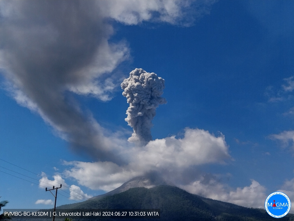
June 27 , 2024.
Indonesia , Lewotobi Laki-laki :
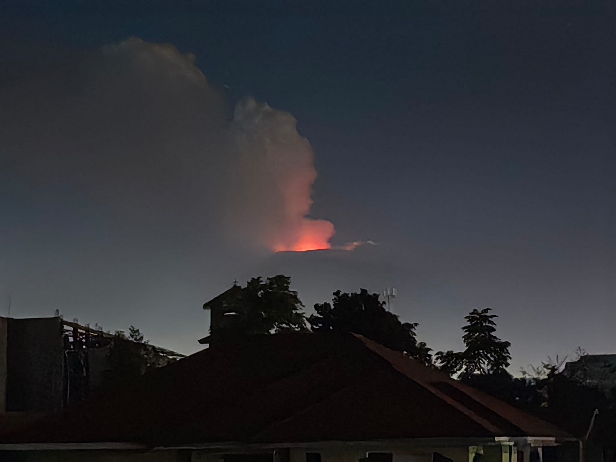
An eruption of Mount Lewotobi Laki – Laki occurred on Thursday June 27, 2024, at 10:27 a.m. WITA with the height of the ash column observed at ± 1000 m above the summit (± 2584 m above the level of the sea). The ash column was observed to be gray with thick intensity, oriented to the West and Northwest. This eruption was recorded on a seismograph with a maximum amplitude of 47.3 mm and a duration of 271 seconds.
VOLCANO OBSERVATORY NOTICE FOR AVIATION – VONA
Issued : June 27 , 2024
Volcano : Lewotobi Laki-laki (264180)
Current Aviation Colour Code : ORANGE
Previous Aviation Colour Code : orange
Source : Lewotobi Laki-laki Volcano Observatory
Notice Number : 2024LWK126
Volcano Location : S 08 deg 32 min 20 sec E 122 deg 46 min 06 sec
Area : East Nusa Tenggara, Indonesia
Summit Elevation : 5069 FT (1584 M)
Volcanic Activity Summary :
Eruption with volcanic ash cloud at 02h27 UTC (10h27 local).
Volcanic Cloud Height :
Best estimate of ash-cloud top is around 8269 FT (2584 M) above sea level or 3200 FT (1000 M) above summit. May be higher than what can be observed clearly. Source of height data: ground observer.
Other Volcanic Cloud Information :
Ash cloud moving from west to northwest. Volcanic ash is observed to be gray. The intensity of volcanic ash is observed to be thick.
Remarks :
Eruption recorded on seismogram with maximum amplitude 47.3 mm and maximum duration 271 second.
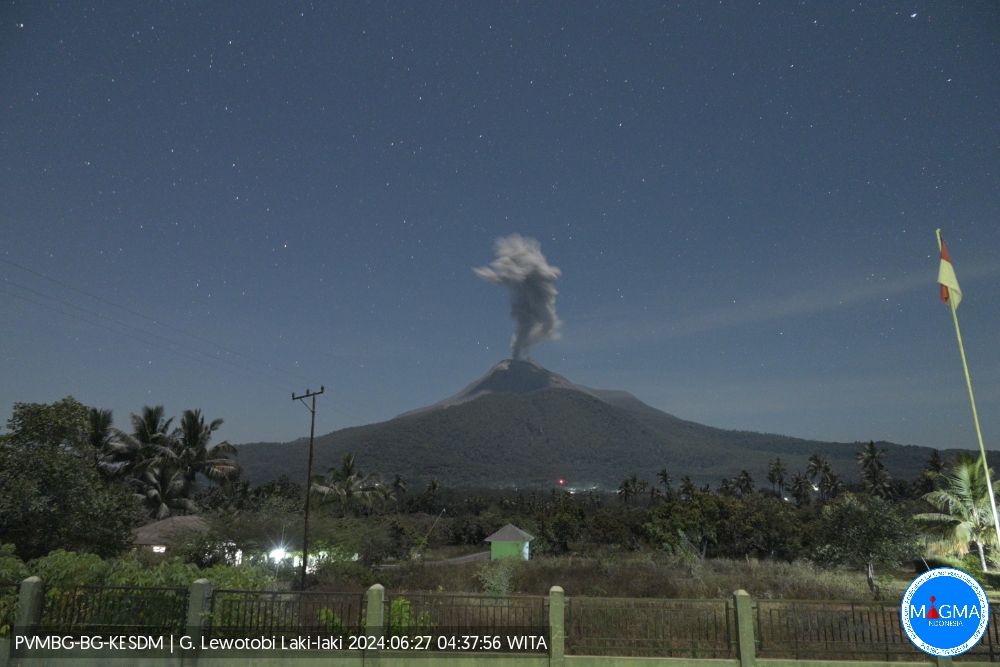
PVMBG reported that eruptive activity at Lewotobi’s Laki-laki volcano continued during 19-25 June. Daily gray or white-and-gray ash plumes rose 100-1,000 m above the summit and drifted SW, W, and NW. According to news articles PVMBG noted that activity remained at high levels and 5-7 intense eruptive events were recorded daily during 16-22 June. Seismicity indicated that magma continued to move to the surface. According to news articles, recent ashfall had contaminated water resources downwind, significantly impacting residents of Dulipali (6 km NNW) in the Ile Bura District and Hokeng Jaya (4 km NW), Klatanlo (5 km NW), Persiapan Padang Pasir, Persiapan Nawokote B, Boru (8 km WNW), Nawokote (5 km W), and Pululera in Wulanggitang District; tanks of clean water were distributed on 23 June. Ashfall was reported in Hikong (15 km W) and Timutawa (15 km WNW), and in agricultural areas in the Taliura District on 22 June, and caused decreased visibility in areas along the Trans-Flores-Highway between Maumere (62 km W) and Larantuka (35 km NE), and in the Wagte and Lela districts. Ashfall on 25 June again impacted residents of Hikong and Timutawa and covered agricultural fields. The Alert Level remained at 2 (the second lowest level on a scale of 1-4) and the public was warned to stay outside of the exclusion zone, defined as a 2-km radius around Laki-laki crater, 3 km to the NNE, and 5 km on the NE flanks.
Sources : PVMBG , GVP.
Italy / Sicily , Etna :
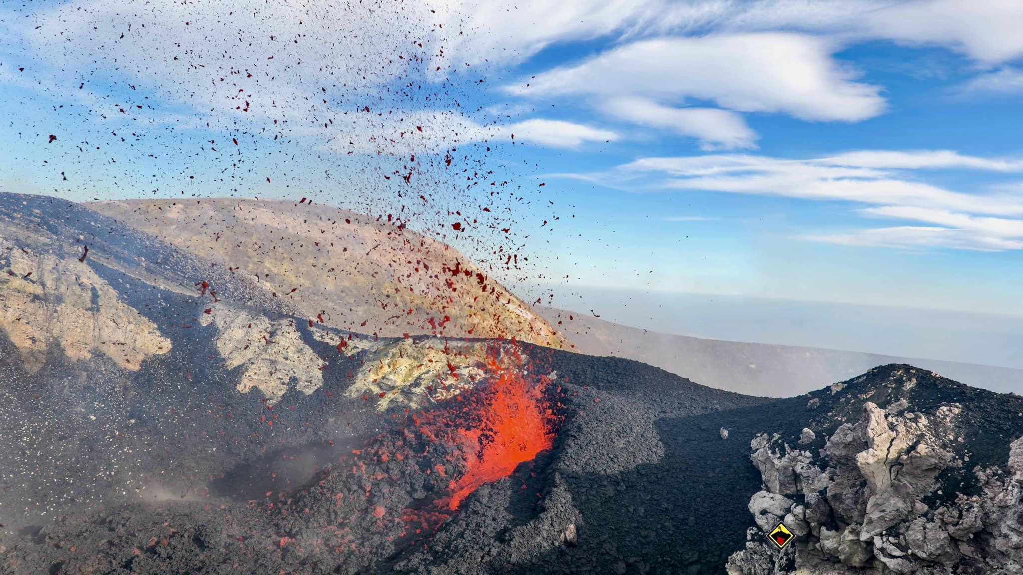
INGV reported that Etna’s Voragine Crater began erupting on 14 June, after more than three years of quiescence, and continued to eject lava through at least 23 June. The activity gradually increased from spattering lava at a new vent to more vigorous with jets of incandescent lava that rose several tens of meters above the crater rim. A new scoria cone grew inside the crater.
Mount Etna, towering above Catania on the island of Sicily, has one of the world’s longest documented records of volcanism, dating back to 1500 BCE. Historical lava flows of basaltic composition cover much of the surface of this massive volcano, whose edifice is the highest and most voluminous in Italy. The Mongibello stratovolcano, truncated by several small calderas, was constructed during the late Pleistocene and Holocene over an older shield volcano. The most prominent morphological feature of Etna is the Valle del Bove, a 5 x 10 km caldera open to the east.
Sources: Sezione di Catania – Osservatorio Etneo (INGV) , GVP.
Photo : Guide Vulcanologiche Etna Nord
Tonga Archipelago , Home Reef :
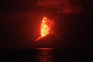
The Tonga Geological Services reported that an eruption at Home Reef was ongoing during 18-25 June. Daily thermal anomalies were identified in satellite images, though the number and intensity of the anomalies were variable. At around 0130 on 21 June an ash-and-gas plume was identified in satellite images drifting SE. Lava continued to expand the SE coastline of the island. The Maritime Alert Level remained at Orange (the second highest level on a four-color scale) and mariners were advised to stay 4 km away from the island, the Aviation Color Code remained at Yellow (the second lowest color on a four-color scale), and the Alert level for residents of Vava’u and Ha’apai remained at Green (the lowest color on a four-color scale).
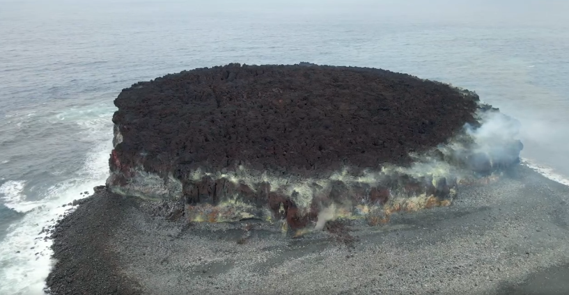
Home Reef, a submarine volcano midway between Metis Shoal and Late Island in the central Tonga islands, was first reported active in the mid-19th century, when an ephemeral island formed. An eruption in 1984 produced a 12-km-high eruption plume, large amounts of floating pumice, and an ephemeral 500 x 1,500 m island, with cliffs 30-50 m high that enclosed a water-filled crater. In 2006 an island-forming eruption produced widespread dacitic pumice rafts that drifted as far as Australia. Another island was built during a September-October 2022 eruption.
Sources : GVP , Tonga Geological Services, Government of Tonga.
Photo : Lacelid Productions ( capture d’écran )
Japan , Sakurajima :
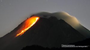
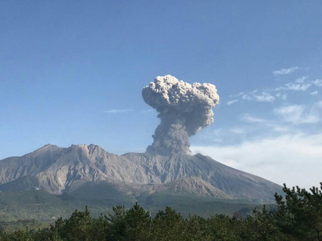
JMA reported ongoing eruptive activity at Minamidake Crater (Aira Caldera’s Sakurajima volcano) during 17-24 June. Nighttime crater incandescence was visible during 17-21 June and very small eruptive events occurred during the rest of the week. An explosion at 0002 on 20 June ejected large blocks 500-700 m above the crater rim and produced an ash plume that rose 1.3 km above the crater rim and drifted NW. The Alert Level remained at 3 (on a 5-level scale), and the public was warned to stay 1 km away from both craters.
The Aira caldera in the northern half of Kagoshima Bay contains the post-caldera Sakurajima volcano, one of Japan’s most active. Eruption of the voluminous Ito pyroclastic flow accompanied formation of the 17 x 23 km caldera about 22,000 years ago. The smaller Wakamiko caldera was formed during the early Holocene in the NE corner of the caldera, along with several post-caldera cones. The construction of Sakurajima began about 13,000 years ago on the southern rim and built an island that was joined to the Osumi Peninsula during the major explosive and effusive eruption of 1914. Activity at the Kitadake summit cone ended about 4,850 years ago, after which eruptions took place at Minamidake. Frequent eruptions since the 8th century have deposited ash on the city of Kagoshima, located across Kagoshima Bay only 8 km from the summit. The largest recorded eruption took place during 1471-76.
Sources: Japan Meteorological Agency (JMA) , GVP.
Photo : Rizal M.
Democratic Republic of Congo: Nyiragongo :
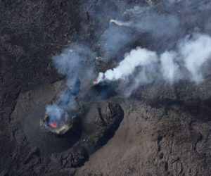
A 25 June satellite image showed a dark elliptical area of lava on Nyiragongo’s crater floor. A central vent produced a gas-and-steam plume the drifted WNW. The lava area was about 560 m E-W and about 690 m N-S. Thermal anomalies identified in SWIR images corresponded to the location of the lava area along with a small area at the central vent.
The Nyiragongo stratovolcano contained a lava lake in its deep summit crater that was active for half a century before draining catastrophically through its outer flanks in 1977. The steep slopes contrast to the low profile of its neighboring shield volcano, Nyamuragira. Benches in the steep-walled, 1.2-km-wide summit crater mark levels of former lava lakes, which have been observed since the late-19th century. Two older stratovolcanoes, Baruta and Shaheru, are partially overlapped by Nyiragongo on the north and south. About 100 cones are located primarily along radial fissures south of Shaheru, east of the summit, and along a NE-SW zone extending as far as Lake Kivu. Many cones are buried by voluminous lava flows that extend long distances down the flanks, which is characterized by the eruption of foiditic rocks. The extremely fluid 1977 lava flows caused many fatalities, as did lava flows that inundated portions of the major city of Goma in January 2002.
Sources : Copernicus , GVP.
Photo : Frank Minani FM