June 17 , 2024.
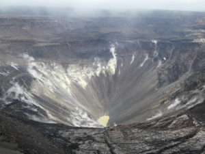
Alaska , Shishaldin :
Minor unrest at Shishaldin Volcano continues, with small, low-frequency earthquakes and tremor occurring throughout the past 24 hours. Nothing unusual was observed in mostly clear satellite data.
Minor rock falls associated with collapse events from the unstable ground in and near the summit crater may occur. The collapse events can generate small clouds of dust likely composed of fine-grained ash.
The diffuse dust clouds dissipate quickly and can produce irregular-shaped deposits near the summit. The last significant ash-producing eruption occurred in November 2023.
Local seismic and infrasound sensors, web cameras, and a geodetic network are used to monitor Shishaldin Volcano. In addition to the local monitoring network, AVO uses nearby geophysical networks, regional infrasound and lighting data, and satellite images to detect eruptions.
Source : AVO
Photo : Beesley, Nick
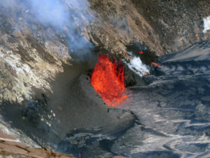
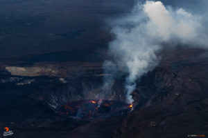
Indonesia , Lewotobi Laki-laki :
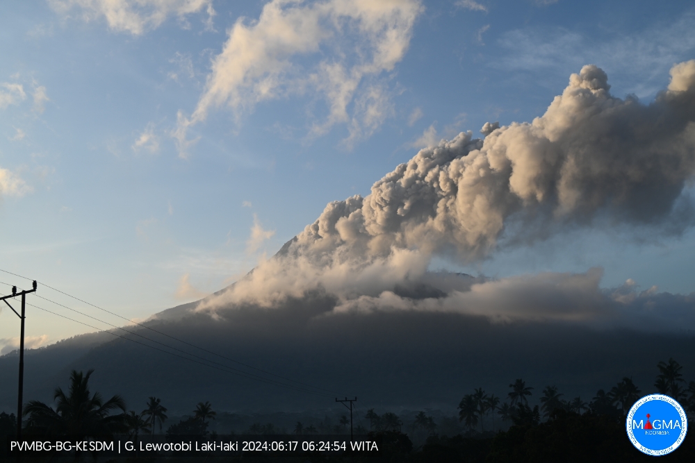
An eruption of Mount Lewotobi Laki-laki occurred on Monday June 17, 2024 at 06:18 WITA with the height of the ash column observed at ± 600 m above the summit (± 2184 m above sea level ). The ash column was observed to be gray with thick intensity, oriented towards the South-West. This eruption was recorded on a seismograph with a maximum amplitude of 14.8 mm and a duration of 447 seconds.
Seismicity observation:
2 eruption earthquakes with an amplitude of 14.7 mm and a seismic duration of 431 to 447 seconds.
2 emission earthquakes with an amplitude of 4.4 to 5.1 mm and duration of the earthquake from 12 to 60 seconds.
2 low-frequency earthquakes with an amplitude of 5.9 to 11 mm and an earthquake duration of 12 to 14 seconds.
4 Shallow volcanic earthquakes with an amplitude of 2.9 to 4.4 mm and an earthquake duration of 7 to 8 seconds.
2 deep volcanic earthquakes with an amplitude of 2.9 to 4.4 mm, and an earthquake duration of 8 to 9 seconds.
2 local tectonic earthquakes with an amplitude of 4.4 to 5.9 mm, and an earthquake duration of 21 to 22 seconds.
1 Distant tectonic earthquake with an amplitude of 4.4 mm, and the earthquake lasted 75 seconds.
RECOMMENDATION
1. Communities around Mount Lewotobi Laki-laki and visitors/tourists do not carry out any activities within a radius of 3 km from the center of the volcano eruption and in the sector of 4 km in the North-North-East direction and 5 km in the direction of the North-East Sector.
2. The public should remain calm and follow the instructions of the regional government and not believe rumors whose origin is unclear.
Source et photo : Magma Indonésie.
Colombia , Galeras :
San Juan de Pasto, June 11, 2024, 3:30 p.m.
Weekly activity bulletin: Galeras Volcano
Regarding the monitoring of the activity of the GALERAS VOLCANO, the COLOMBIAN GEOLOGICAL SERVICE (SGC), an entity attached to the MINISTRY OF MINES AND ENERGY, reports that:
Compared to the previous week, during the period evaluated between June 4 and 10, 2024, an increase was observed both in the seismic occurrence and in the energy released, maintaining the predominance of seismicity associated with the fracture rocks within the volcanic system. The fracture earthquakes were located mainly near the active cone at distances less than 1 km and at depths less than 3 km relative to its summit (4,200 m altitude).
A few events were located scattered across the volcanic region, at distances up to 7 km, with depths less than 6 km and a maximum local magnitude of 1.
Gas emissions were recorded in the fumarole fields of Las Chavas, to the West, and El Paisita, to the North of the active cone, with small white columns, of low height and variable dispersion due to the action of the winds. The other geophysical and geochemical parameters of volcanic monitoring showed stability.
Volcanic activity remains in a YELLOW ALERT state: active volcano with changes in the behavior of the base level of monitored parameters and other manifestations.
Source et photo : SGC
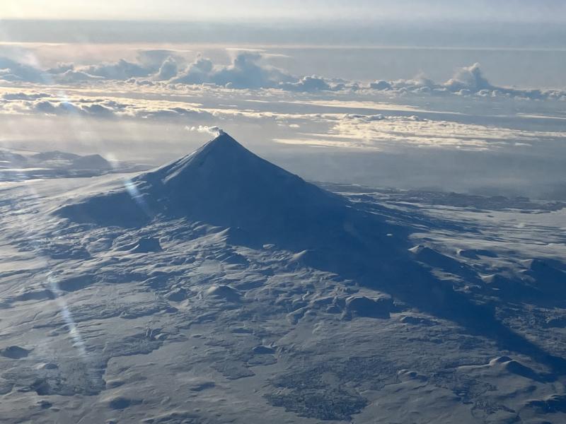
Ecuador , Sangay :
DAILY REPORT ON THE STATE OF THE SANGAY VOLCANO, Sunday June 16, 2024.
Information Geophysical Institute – EPN.
Surface activity level: High, Surface trend: No change
Internal activity level: High, Internal trend: No change
Seismicity: From June 15, 2024, 11:00 a.m. to June 16, 2024, 11:00 a.m.:
Due to data transmission problems, it was not possible to count volcanic events.
Precipitation/Lahars:
Rains were recorded in the volcano area without generating mudslides and debris. **In the event of heavy rains, these could remobilize the accumulated material, generating flows of mud and debris which would descend down the sides of the volcano to flow into adjacent rivers.
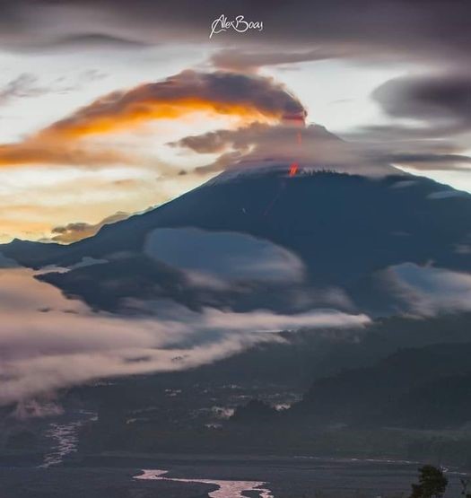
Emissions/ash column:
Yesterday, at the time of writing this report, thanks to the monitoring system and satellite cameras, clouds and bad weather were recorded in the areas surrounding the volcano, so it was not possible to visualize the gas or ash emissions. No report has been received from the VAAC in Washington either.
Other monitoring parameters:
The FIRMS and MIROVA satellite systems, respectively, have not recorded any thermal anomalies over the past 24 hours.
Observation:
From yesterday afternoon until today’s break, thanks to the monitoring system and satellite cameras, the volcano remained completely cloudy without presenting any news.
Alert level: yellow
Source : IGEPN
Photo : AlexBoasphoto
Guatemala , Fuego :
Weather conditions: Cloudy
Wind: South-East
Precipitation: 20.6 mm.
Activity:
The Fuego Volcano Observatory reports cloudy conditions that prevent the observation of volcanic activity since yesterday. Explosions were not observed, which, according to the infrasound recording, are of weak and sometimes moderate characteristics. During the night and early morning, low rumbling sounds were heard with shock waves that vibrated the doors, roofs and windows of homes in communities near the volcano.
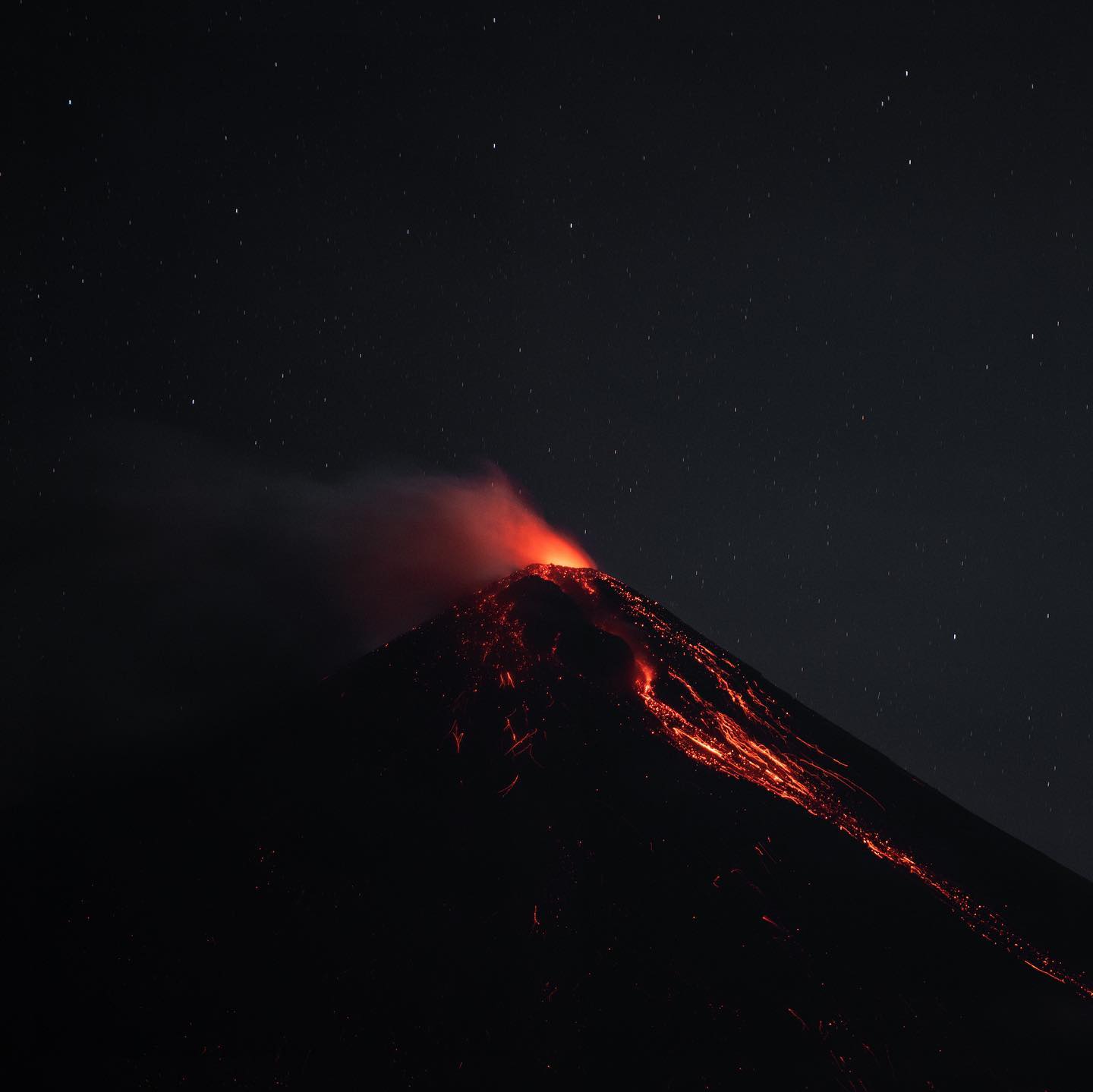
Noises were also heard due to the descent of weak to moderate avalanches towards the ravines, notably that of Ceniza. Due to the wind direction, a light ash fall could occur in the San Pedro Yepocapa and Acatenango region. In the afternoon and evening, the heavy rains forecast could cause lahars to descend in different ravines of the volcano.
Source : Insivumeh
Photo : Diego Rizzo