May 21 , 2024.
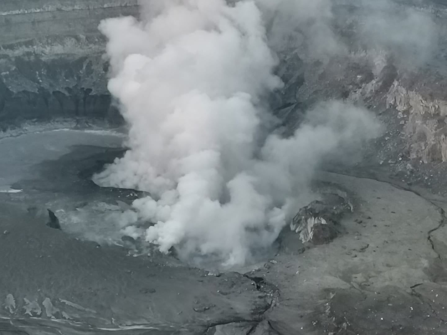
Indonesia , Ibu :
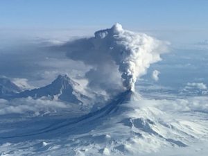
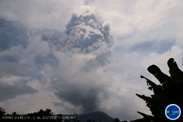
Mount Ibu exhibited an eruption on Tuesday, May 21, 2024 at 2:01 p.m. WIT with the height of the ash column observed at ±5,000 m above the summit (±6,325 m above sea level). The ash column was observed to be gray with thick intensity, oriented to the West and Northwest. At the time of writing, the eruption was still ongoing.
VOLCANO OBSERVATORY NOTICE FOR AVIATION – VONA
Issued : May 21 , 2024
Volcano : Ibu (268030)
Current Aviation Colour Code : RED
Previous Aviation Colour Code : orange
Source : Ibu Volcano Observatory
Notice Number : 2024IBU017
Volcano Location : N 01 deg 29 min 17 sec E 127 deg 37 min 48 sec
Area : North Maluku, Indonesia
Summit Elevation : 4240 FT (1325 M)
Volcanic Activity Summary :
Eruption with volcanic ash cloud at 05h01 UTC (14h01 local).
Volcanic Cloud Height :
Best estimate of ash-cloud top is around 20240 FT (6325 M) above sea level or 16000 FT (5000 M) above summit. May be higher than what can be observed clearly. Source of height data: ground observer.
Other Volcanic Cloud Information :
Ash cloud moving from west to northwest. Volcanic ash is observed to be gray. The intensity of volcanic ash is observed to be thick.
Remarks :
Eruption and ash emission is continuing. Eruption recorded on seismogram with maximum amplitude 28 mm.
Source et photo : Magma Indonésie.
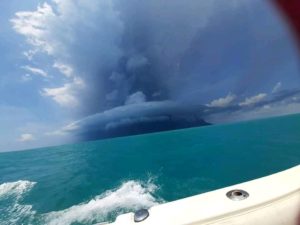
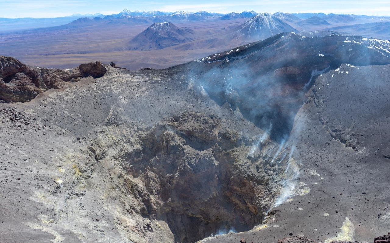
Chile , Lascar :
Seismology
The seismological activity of the period was characterized by the recording of:
10 seismic events of type VT, associated with the fracturing of rocks (Volcano-Tectonics). The most energetic earthquake had a Local Magnitude (ML) value equal to 0.9, located 0.3 km south-southwest of the volcanic building, at a depth of 1.9 km in reference to the crater.
94 LP type seismic events, associated with fluid dynamics inside the volcanic system (Long Period). The size of the largest earthquake evaluated from the Reduced Displacement (RD) parameter was equal to 13 cm2.
Fluid geochemistry
No anomalies have been reported in the emissions of sulfur dioxide (SO2) into the atmosphere in the area near the volcano, according to data published by the Tropospheric Monitoring Instrument (TROPOMI) and the Sulfur Dioxide Group of the Ozone Monitoring Instrument (OMI).
Thermal anomalies by satellites
During the period, no thermal alerts were recorded in the area associated with the volcano, according to the analytical processing of Sentinel 2-L2A satellite images, in combination of false color bands.
Geodesy
The geodetic activity of the period was characterized by:
-Small horizontal displacements.
-Small vertical displacement.
Consequently, no changes attributable to the internal dynamics of the volcano generating changes in surface deformation are observed.
Surveillance cameras
The images provided by the fixed camera, installed near the volcano, did not record degassing columns or variations linked to surface activity.
Activity remained at levels considered low, suggesting stability of the volcano.
The technical volcanic alert is maintained in:
GREEN TECHNICAL ALERT: Active volcano with stable behavior – There is no immediate risk
Observation:
An area with a radius of 500 meters is considered a potential danger zone near the active crater.
Source : Sernageomin
Photo : Vulcanopro
Colombia , Puracé :
Popayan, May 20, 2024, 3:30 p.m.
Regarding the monitoring of the activity of the PURACE VOLCANO – LOS COCONUCOS VOLCANIC CHAIN, the COLOMBIAN GEOLOGICAL SERVICE (SGC), an entity attached to the MINISTRY OF MINES AND ENERGY, reports that:
From yesterday until the time of publication of this bulletin, the seismic activity associated with fracture processes, as well as that linked to the movement of fluids, maintained a behavior similar to that observed in previous days, with a downward trend of the number of earthquakes. The fracture events were located mainly under the crater of the Puracé volcano at depths less than 2 km and with low magnitudes. Seismicity linked to the movement of fluids continues to be concentrated in the crater sector, at depths less than 2 km.
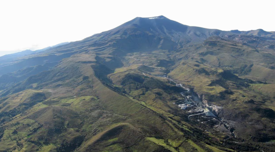
In the images obtained this morning, it was not possible to have a clear view of the crater. Ground deformation processes, carbon dioxide (CO2) and sulfur dioxide (SO2) concentrations maintain the observed trend, with values remaining above known baselines for this volcano.
The SGC confirms that the alert state of the PURACE VOLCANO continues at ORANGE: volcano with significant changes in the monitored parameters.
Source et photo : SGC
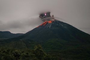
Guatemala , Fuego :
Weather conditions: cloudy.
Wind: North-East.
Precipitation: 23.4 mm.
Activity:
Seismic stations and INSIVUMEH cameras show small, moderate and a few strong explosions, which occur at a frequency of 3 to 9 per hour, raising columns of gas and ash to heights between 4,500 and 4,800 meters above sea level. above sea level (14,763 to 15,748 feet). These move towards the West and South-West, carrying the ashes up to 30 kilometers or more. The explosions produced small to moderate avalanches around the crater towards the Ceniza, Las Lajas and Seca ravines, and produce incandescent pulses of 350 and 400 meters at night.
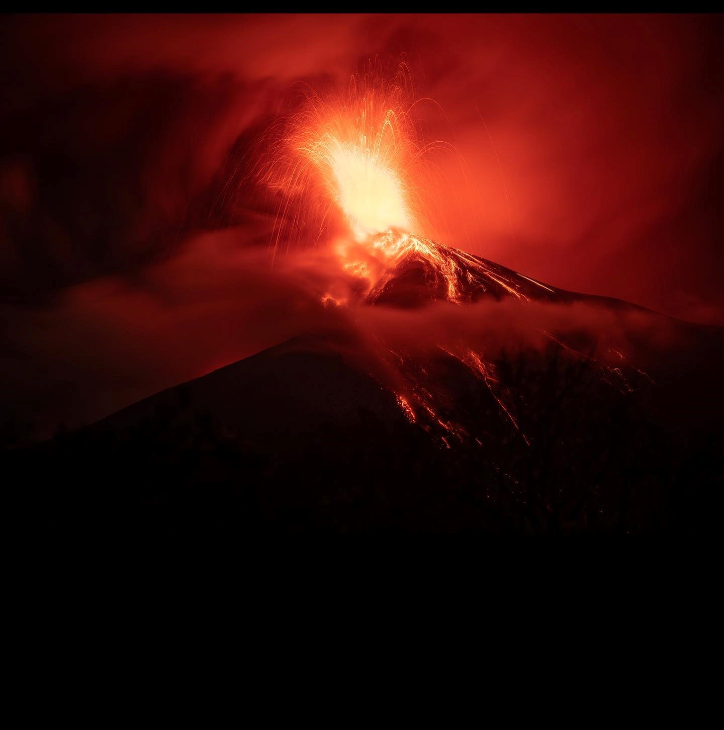
This activity is accompanied by low rumbling sounds and weak to moderate shock waves. Due to wind direction, light falls of fine ash may occur over Los Yucales, Yepocapa, Santa Sofía, Sangre de Cristo, Ojo de Agua, Santa Emilia, Palo Verde, Panimache I and II, among others. In the afternoon and evening, moderate and heavy rains will continue in the volcanic area, so lahars may descend. It is recommended to take precautions when passing vehicles through ravines.
Source : Insivumeh
Photo : Diego Rizzo
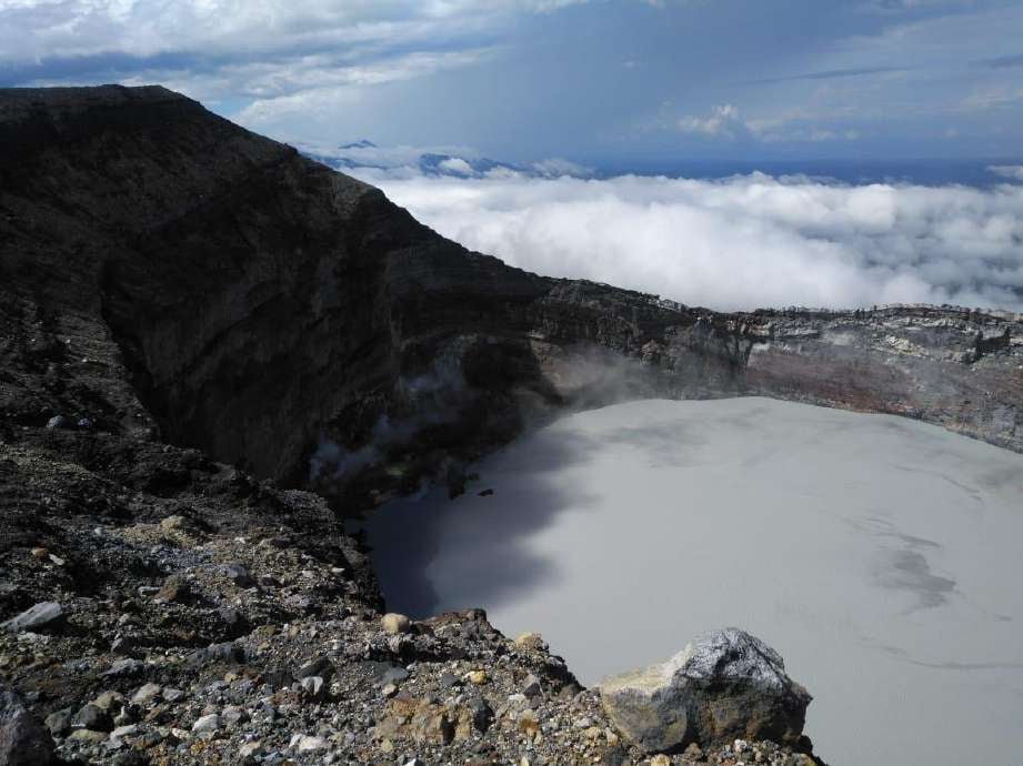
Costa Rica , Poas / Rincon de la Vieja :
Volcan Poas
Lat: 10.20°N;
Longitude: 84.23°W;
Altitude: 2687 m
Current activity level: Warning
The seismic and acoustic tremor showed some oscillations this week. Before the eruptive activity of May 12 and 15, an increase in tremors was observed. The observed eruptive activity is composed of small, frequent pulses (several per minute over a period of a few hours). Pulses are identified using infrasound recordings and visual observation. The column of ejected solid material does not exceed 15 m above the edge of the mouth C. Frequent low frequency (LP) earthquakes are recorded. In recent days, a contraction of the crater continues to be observed and an uplift is observed to the south of the crater.
The gas compositions remain relatively stable, with SO2/CO2 ratios close to 2.3 and H2S/SO2 ratios close to 0.5. The SO2 concentration recorded by the ExpoGAS station at the lookout reached a maximum of 4.3 ppm this week. No SO2 was detected in the atmosphere this week. On the other hand, the SO2 flux of the previous week (231 ± 136 t/d) was lower than that of the previous week (356 ± 277 t/d). The rains this week allowed us to have water sporadically in the C mouth, but not to measure the level.
Rincón de la Vieja Volcano
Lat: 10.83°N;
Longitude: 85.34°W;
Altitude: 1916 m
Current activity level: Caution
During this week, a total of 115 small eruptions were recorded. None of them generated lahar descent, but generated small plumes (< 500 m) rich in water vapor, gas and aerosols. In addition to the eruptions, acoustic signals associated with the bubbling have been recorded since April 28 with variations in energy.
From April 28 until the time of this bulletin, frequent acoustic signals associated with bubbling or small geyser-like eruptions have been recorded. From May 8, acoustic signals linked to very frequent phreatic eruptions were recorded (approximately every 3 to 4 minutes). The exponential increase in seismic tremor energy observed from April 17 decreased compared to May 6, almost returning to previous levels of April 2024. The background tremor remains in a variable frequency range of 0.7 at 6 Hz. This tremor is accompanied by long period (LP) type events coinciding with the appearance of bubbling. Distal and proximal volcano-tectonic earthquakes associated with rock breakages are also recorded.
Geodetic measurements show that the extension of the base of the volcano observed in recent months has ceased, as has the uplift of the summit. Gas compositions remain relatively stable, with CO2/SO2 ratios close to 1 (a little lower than normal) and H2S/SO2 ratios close to 0.2. The Sentinel-5P satellite sensor has not detected any SO2 in the atmosphere emitted by the Rincón since May 3, 2024. During the previous week, an SO2 flux of 283 ± 166 t/d was recorded, which has remained relatively constant over the past two weeks. Satellite observations from international collaborations confirmed a low lake level and the appearance of what could be a circular cone of material 30 m in diameter at the bottom of the crater.
Source : Ovsicori
Photos : Maria Martinez , Waldo Taylor de ICE. ( archives).