November 03 , 2018.
Ecuador , Reventador :
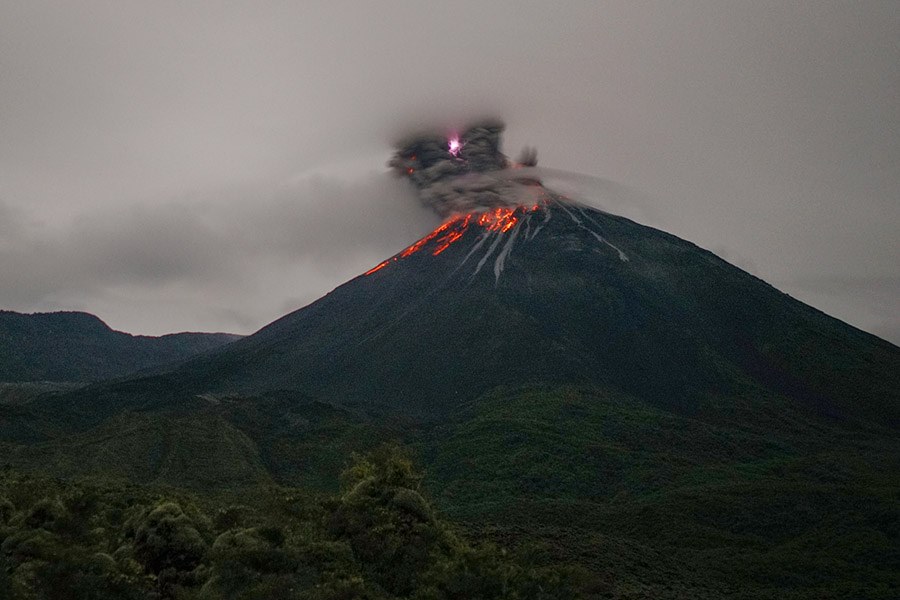
Quito. The Geophysical Institute of the National Polytechnic School observed an incandescence in the crater of the Ecuadorian volcano Reventador, accompanied by the rolling of blocks, as reported today.
He noted that the blocks had descended to about 600 meters under the crater on the southeast flank.
In November 2002, an eruption of the Reventador raised a large cloud of ashes that, as a result of the winds, spread to Quito and covered parts of the capital.
The Reventador volcano is located about 90 kilometers east of Quito, on a spur of the eastern branch of the Andean mountain range that stops at the beginning of the Amazon basin.
At 3,560 meters above sea level, this volcano began its current eruptive process in 2002 and is characterized by explosions, gas and ash emissions, lava flows and lahars.
Information Geophysical Institute – EPN
Level of activity:
Superficial: High. Surface trend: No change
Internal: High. Internal trend: No change
Seismicity (events):
Long Period Type (LP): 53
Explosions (EXP): 45
Transmit Tremor (TE): 6
Harmonic tremor (TA): 2
Gas flow (SO2) (tonnes / day): 386.0 +/- 132.0 Number of measures validated: 5
Rains / lahars: Light rains have been reported, which has not caused any inconvenience.
Emission / Ash Column: On the afternoon of yesterday and today, several emissions of steam, gas and ash were recorded, the highest exceeding 1,000 meters above the summit and dispersed in the west direction.
Other monitoring parameters: No change.
Observations: In the night of yesterday, an incandescence was observed in the crater, in addition to the rolling of blocks descending to 600 meters on the South-East flank.
Source : elnorte.ec, IGEPN.
Photo : Martin Rietze .
Alaska , Veniaminof :
56°11’52 » N 159°23’35 » W,
Summit Elevation 8225 ft (2507 m)
Current Volcano Alert Level: WATCH
Current Aviation Color Code: ORANGE
Low-level eruptive activity occurred at the intracaldera cone of Veniaminof volcano throughout the past week, indicated by relatively continuous seismic tremor, as well as by elevated surface temperatures and an eruption plume observed in satellite and web camera images. The eruption is characterized by low-level lava spattering, a lava flow, and variable emissions of steam and volcanic ash.

Recent satellite observations show that the lava flow extends about 1.2 km (0.75 miles) from the vent. Fractures in the summit ice sheet adjacent to the lava flow are caused by melting. The production of volcanic ash varies over time and is rarely accompanied by a discernible change in seismic activity. Trace ash fallout in local communities is possible under strong wind conditions and increased ash emissions
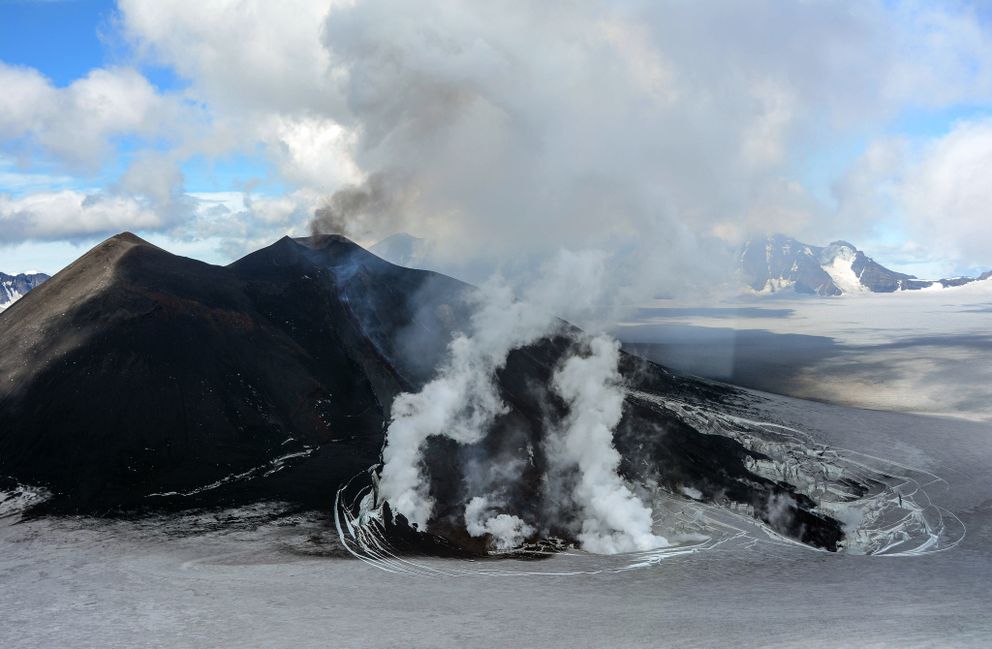
Mount Veniaminof volcano is an andesitic stratovolcano with an ice-filled 10-km diameter summit caldera located on the Alaska Peninsula, 775 km (480 mi) southwest of Anchorage and 35 km (22 mi) north of Perryville. Veniaminof is one of the largest (~300 cubic km; 77 cubic mi) and most active volcanic centers in the Aleutian Arc and has erupted at least 13 times in the past 200 years. Recent significant eruptions of the volcano occurred in 1993-95, 2005, and 2013. These were Strombolian eruptions that produced lava fountains and minor emissions of ash and gas from the main intracaldera cone. During the 1993-95 activity, a small lava flow was extruded, and in 2013, five small lava flows effused from the intracaldera cone over about five months. Minor ash-producing explosions occurred nearly annually between 2002 and 2010. Previous historical eruptions have produced ash plumes that reached 20,000 ft above sea level (1939 and 1956) and ash fallout that blanketed areas within about 40 km (25 mi) of the volcano (1939).
Source : AVO
Photos : Bernice, Kaylynn ( 29 Octobre 2018 ) , Anchorage Daily News.
Colombia , Galeras :
Weekly activity bulletin of the Galeras volcano.
The level of activity of the volcano continues at the level: YELLOW LEVEL ■ (III): CHANGES IN THE BEHAVIOR OF THE VOLCANIC ACTIVITY.
Following the activity of the VOLCÁN GALERAS, the COLOMBIAN GEOLOGICAL SERVICE (SGC) informs that:
Between October 23rd and 29th, 2018, seismicity of the Galeras volcano was for the most part linked to the fracturing of rocks in the volcanic building (volcano-tectonic earthquakes), maintaining low levels of occurrence as well as released seismic energy. . Most of this seismicity has been located in the northeastern sector of the main crater, at epicentral distances between 4 and 11 km, with depths of up to 9 km from the summit (4200 m altitude) and local magnitudes not exceeding M 2.1 on the Richter scale. No earthquakes have been reported as felt.
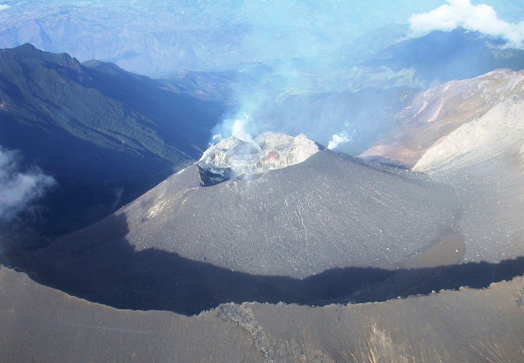
During the week evaluated, white gas emissions, low pressure and low height were observed.
The other geophysical and geochemical parameters of Galeras volcano monitoring did not show any significant variations.
The Colombian geological service remains attentive to the evolution of the volcanic phenomenon and will continue to inform the changes observed in good time.
Source : SGC
Guatemala , Santiaguito :
INCREASE IN THE ACTIVITY OF AVALANCHES, Guatemala, November 2, 2018, 12:55 (local time).
Activity type: Peléenne
Morphology: Dacitic Domes Complex
Geographical location: 14 ° 44 ’33 ˝ Latitude N; 91 ° 34’13˝ Longitude O.
Height: 2,500msnm
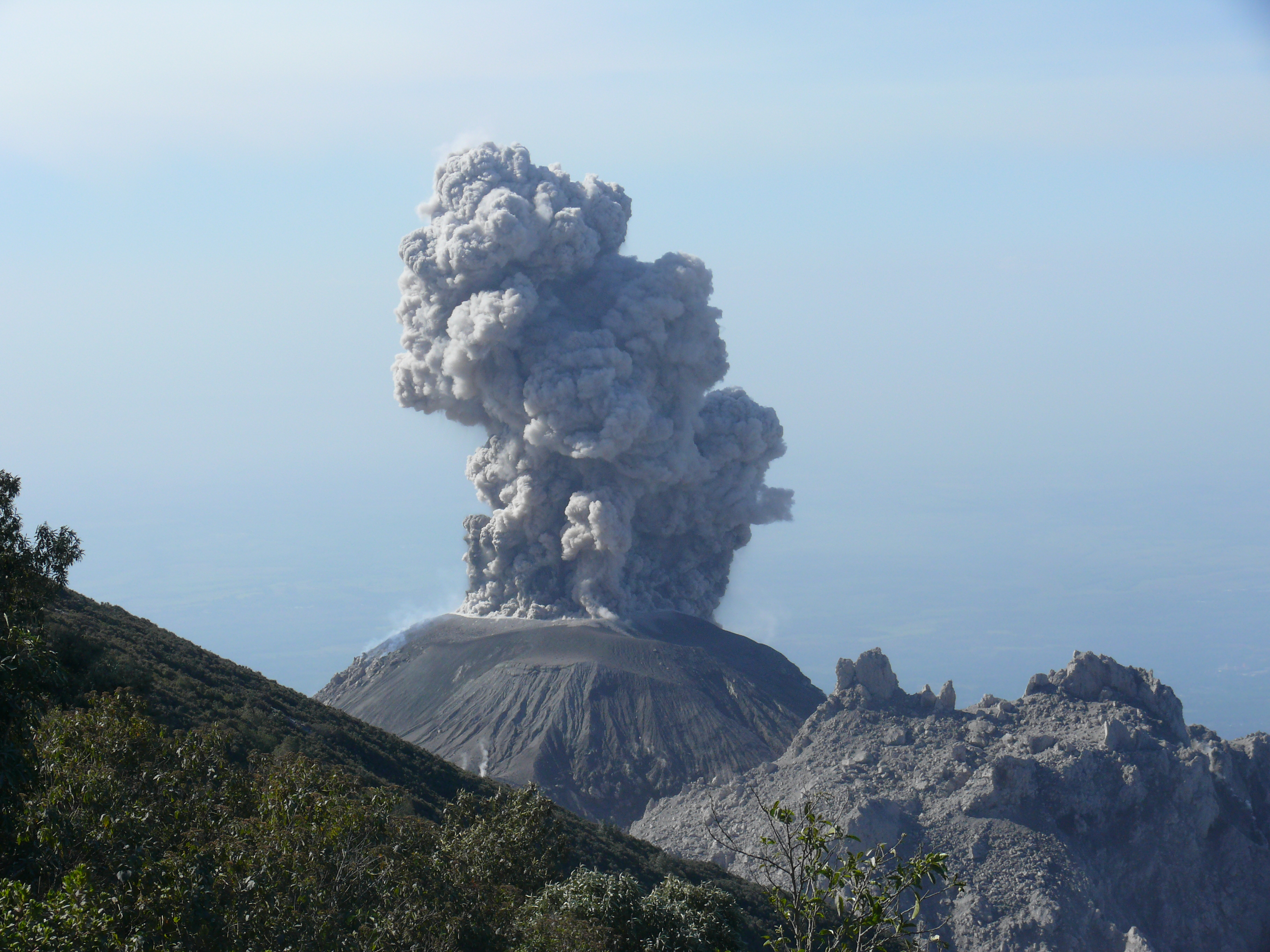
Avalanches on the south and southeast flanks of Santiaguito volcano have multiplied in recent days, traveling long distances from the crater dome to the base of the volcano.
Avalanches are moderate and some are strong, causing the ash to disperse and displacing volcanic materials of different sizes. So, this is causing ash falls in the volcanic perimeter.
In the same way, the volcano maintains weak explosions at the origin of columns of ashes which rise to a height of approximately 3,300 meters (10,827 feet), moving towards the South-West from the slopes of the volcano.
Source : Insivumeh
Photo : Inconnu.
Costa Rica , Turrialba / Rincon de la Vieja :
Daily report on the state of volcanoes.
Date: 02 November 2018, Updated at: 10:51:00.
Turrialba Volcano:
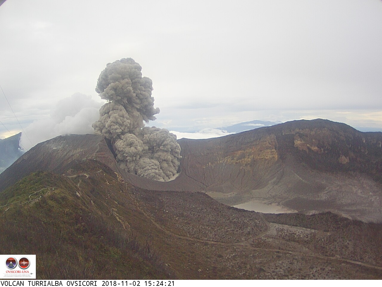
November 2, 2018. # VolcánTurrialba 15:23 local time. Emulsion ash lasting a few minutes. Wind southwest direction southwest to the central valley
On November 2, 2018, at 5.30 am local time, there was an eruption on the Turrialba volcano, with a column that rose 500 meters above crater height and at 3840 meters above sea level. (meters above sea level, 12595.2 ft).
Duration of the activity: 70 minutes.
The seismic activity is similar to that of yesterday.
At the time of writing, winds are blowing toward the southwest.
Yesterday in the afternoon and this morning, passive ash eruptions were observed. The most important that could be observed was between 5:30 and 6:49. The ashes went south and could have affected Pacayas, Orosi, Cachi Pjibaye, Turrialba and Suiza.
Rincon de la Vieja volcano:

Rincón de la Vieja Volcano. 18 October 2018. Photograph by Christian Zúñiga Gutiérrez from Buenos Aires de Upala.
On November 2, 2018 at 00:00:00 local time, there is an eruption on the Rincon de la Vieja volcano. The height reached by the column due to visibility conditions of the site is unknown.
Duration of the activity: minutes.
The seismic activity is similar to that of yesterday.
The wind direction is unknown at the moment.
A signal associated with a possible eruption was recorded yesterday at 2:23 pm.
Source : OVSICORI-UNA
Photos : Ovsicori , Christian Zúñiga Gutiérrez