April 05 , 2024.
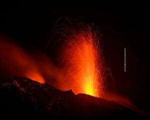
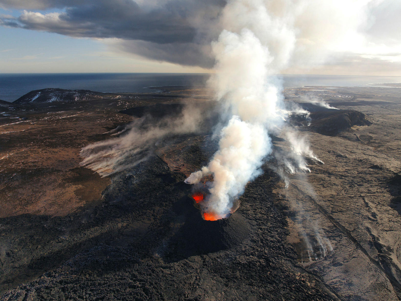
Iceland : Reykjanes Peninsula :
The eruption at the Sundhnúkur crater row continues . Inflation at Svartsengi has not been detected in recent days
Updated 2. April at 17:30 UTC
Lately, vegetation fires have started around the lava field, and is an ongoing risk while the weather is dry.
Gas pollution is dispersed to the southwest and later to the west and is likely to be detected occasionally in Grindavík and possibly in Hafnir. Gas distribution forecast and air quality can be monitored.
Lava margins have reached considerable heights and can be unstable.
Hazard assessment unchanged.
The eruption at the Sundhnúkur crater row continues and two craters are now active. The third crater, which was much smaller than the other two, was extinguished at Easter. Volcanic tremor remains stable.
Inflation in Svartsengi has not been detected in recent days, indicating that less magma accumulates in the magma reservoir beneath Svartsengi, and flows instead towards the craters where it erupts. A balance may be reached between the influx of magma into the Svartsengi reservoir and the eruptive craters, but geochemical surveys might confirm this in the future.
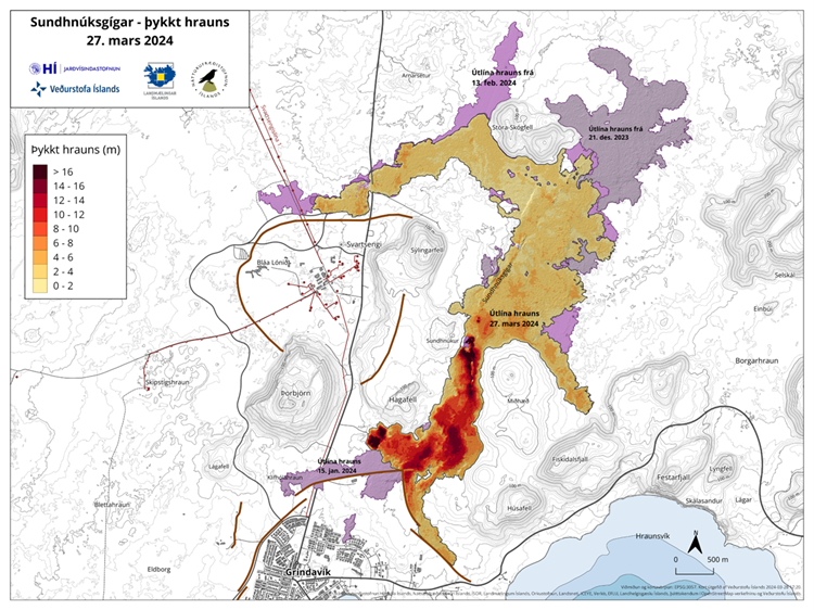
Experts from the National Land Survey of Iceland have processed satellite data from 27 March showing that the lava field was then 5.99 km2 and the volume of lava since the beginning of the eruption was 25.7 ± 1.9 million m3. The average extrusive rate of lava from the craters was estimated at 7.8 ± 0.7 m3/s, which is very comparable to the extrusion rate during the first phase of the Geldingadalir eruption in 2021. The aim is to take aerial photographs of the area in the coming days to get updated extrusion rates since 27 March, which will give further insights into the development of the eruptive activity. The following map shows the lava flow field and its thickness as it was on 27 March.
Vegetation fires around the lava field
Lately, vegetation fires have broken out around the lava field and are a persistent risk as long as the weather is dry.
Lava margins have reached considerable heights and may be unstable. Sudden, rapid lava explosions can occur if new lava lobes erupt from the edge of a lava margin.
In recent days, high levels of hydrogen sulfide have sometimes been detected in Grindavík. The weather forecast today (Tuesday) is for Northeast and later East winds of 5 to 13 m/s at the eruption site. Gaseous pollution is therefore dispersed towards the South-West, then towards the West, and is likely to be detected occasionally in Grindavík and possibly in Hafnir. East and South-East winds of 3 to 10 m/s tomorrow causing gas pollution to shift towards the West and North-West, and could therefore be detected in many parts of the Western Reykjanes region , including Reykjanesbær.
Source : IMO
Photos : mbl.is/Hörður Kristleifsson , IMO.
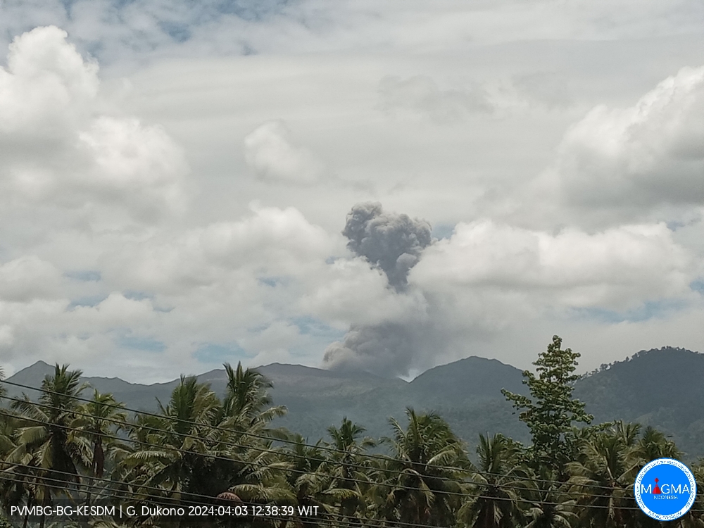
Indonesia , Dukono :
An eruption of Mount Dukono occurred on Wednesday, April 3, 2024 at 12:37 p.m. WIT with the height of the ash column observed at ±1,250 m above the summit (±2,337 m above sea level) . The ash column was observed to be white to gray in color with thick intensity, oriented towards the West. This eruption was recorded on a seismograph with a maximum amplitude of 6 mm and a duration of 82.75 seconds.
Observation of seismicity:
19 eruption/explosion earthquakes with an amplitude of 4 to 34 mm and an earthquake duration of 34.22 to 81.32 seconds.
2 deep tectonic earthquakes with an amplitude of 7-34 mm, and earthquake duration 85.85-169.29 seconds.
1 Continuous tremor with an amplitude of 0.5 to 5 mm, dominant value of 2 mm.
RECOMMENDATION
(1) People around Mount Dukono and visitors/tourists are advised not to do activities, climb or approach Malupang Warirang Crater within a 3 km radius.
(2) Since eruptions with volcanic ash occur periodically and the distribution of ash follows the direction and speed of the wind, so that the landing area of the ash is not fixed, it is recommended for people around Mount Dukono to always have masks/nose masks. and mouth coverings to use when necessary to avoid the threat of volcanic ash to the respiratory system.
Source et photo : Magma Indonésie.
Colombia , Nevado del Ruiz :
Weekly activity bulletin: Nevado del Ruiz Volcano
Regarding the monitoring of the activity of the NEVADO DEL RUIZ VOLCANO, the MINISTRY OF MINES AND ENERGY, through the COLOMBIAN GEOLOGICAL SERVICE (SGC), reports that:
In the week between March 26 and April 1, 2024, the volcano continued to exhibit unstable behavior. Compared to the previous week, the main variations in the parameters monitored were:
– Seismicity linked to fluid dynamics inside volcanic conduits has increased in the number of earthquakes recorded and in the seismic energy released. Most seismic signals were associated with pulsatile emissions of ash and gas into the atmosphere. Energy levels were low to moderate at times. Thanks to the cameras used to monitor the volcano, several ash emissions and some temperature changes of the emitted material associated with some of these seismic signals have been confirmed.
– Seismic activity associated with the fracturing of rocks within the volcanic edifice has maintained similar levels in the number of earthquakes recorded and in the seismic energy released. The earthquakes were located in the Arenas crater and on the different flanks of the volcano, mainly at distances less than 7 km from the crater. On the east, northeast and northwest flanks of the volcano, seismicity showed a greater concentration of earthquakes. The depths of the events varied between less than 1 and 7 km from the volcano summit. The highest magnitude of the week was 2.0, corresponding to the March 28 earthquake at 5:06 p.m., located about 6 km east of the crater, 4 km deep. In addition, seismicity linked to the activity of the lava dome (protrusion or mound) located at the bottom of the crater was recorded, although to a lesser extent than last week. The energy levels of this type of seismicity were low.

– The emission of water vapor and gas into the atmosphere continued at the volcano. Sulfur dioxide (SO2) outgassing rates were variable and continued to decline.
This trend is due, in part, to the fact that atmospheric conditions (wind direction, cloudiness) have been unfavorable in recent weeks for the measurement of this gas. The maximum height of the gas or ash column was approximately 1,000 m. This value was estimated at the summit of the volcano on April 1, during the emission of ash recorded at 5:15 a.m. mr. The management of
dispersion of the gas column was predominant towards the southwest and northwest flanks of the volcano.
– When monitoring surface activity from satellite monitoring platforms, several thermal anomalies were detected at the bottom of Arenas Crater with low to moderate energy levels. For this week, the heavy cloudiness in the area did not favor their detection.
The alert status for volcanic activity remains at: YELLOW ALERT: ACTIVE VOLCANO WITH CHANGES IN THE BEHAVIOR OF THE BASE LEVEL OF MONITORED PARAMETERS AND OTHER MANIFESTATIONS
Source et photo : SGC
Hawaii , Kilauea :
Tuesday, April 2, 2024, 8:57 AM HST (Tuesday, April 2, 2024, 18:57 UTC)
19°25’16 » N 155°17’13 » W,
Summit Elevation 4091 ft (1247 m)
Current Volcano Alert Level: ADVISORY
Current Aviation Color Code: YELLOW
Activity Summary:
Kīlauea volcano is not erupting. Low-level seismicity continues beneath the summit and Southwest Rift Zone, while rates of ground deformation remain low.
Summit Observations:
Low levels of seismicity continue beneath Kīlauea’s summit. During the past week, the rate of earthquakes here were slightly elevated, but daily earthquake counts remain well below those detected during the January–February intrusion or prior to recent summit eruptions. At this time, earthquake depths beneath the summit are primarily 0.3–1.6 miles (0.5–2.5 kilometers) below the surface, and magnitudes are typically below M2.0.
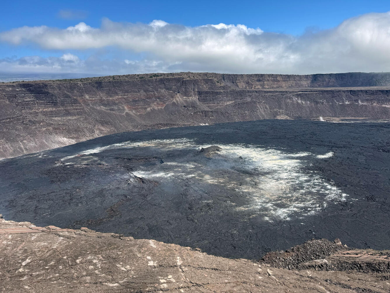
HVO geologists made a routine visit to check on equipment at the summit of Kīlauea today, and had clear views across the floor of Halema‘uma‘u. The central portion of this photo is the region where much of the lava lake activity has occurred over the previous few years, with the area now showing only wispy plumes of weak gas emission. The summit region has been quiet in recent weeks, with low rates of seismicity and ground deformation.
Ground deformation continues at low rates across Kīlauea, with tiltmeters near Uēkahuna and Sand Hill—respectively northwest and southwest of the summit caldera—showing only modest changes over the past week.
Sulfur dioxide (SO2) gas emissions have remained at low, noneruptive levels since October 2023. An SO2 emission rate of approximately 60 tonnes per day was recorded on March 27.
Rift Zone Observations:
Low levels of seismicity continue beneath Kīlauea’s Southwest Rift Zone. During the past week, daily earthquake counts remained well below those detected during the January–February intrusion. No unusual activity has been noted along the East Rift Zone. We continue to closely monitor both rift zones.
Source : HVO
Photo : USGS / M. Patrick.
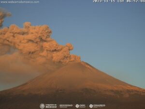
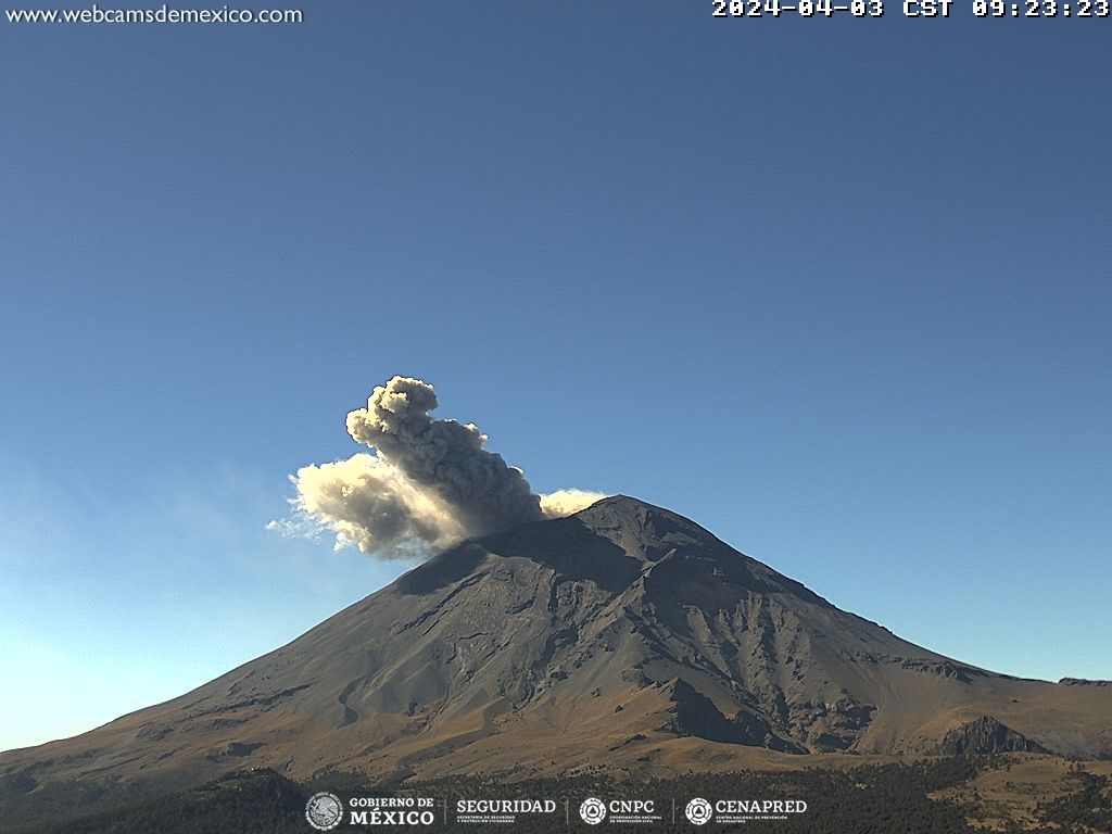
Mexico , Popocatepetl :
April 4, 11:00 a.m. (April 4, 5:00 p.m. GMT). Activity from the last 24 hours
30 low-intensity exhalations were recorded, accompanied by water vapor and other volcanic gases.
During the morning and at the time of this report, a continuous emission of water vapor and other gases is observed, in an East-Northeast direction.
The Popocatépetl volcanic warning fire is in yellow phase 2.
The scenarios planned for this phase are:
A few small to moderate explosions
Appearance of tremors of variable amplitude
Light to moderate ash rain in surrounding towns and some more distant towns
Ejection of incandescent fragments within the exclusion radius of 12 kilometers
Source et photo : Cenapred